It looks like you're using an Ad Blocker.
Please white-list or disable AboveTopSecret.com in your ad-blocking tool.
Thank you.
Some features of ATS will be disabled while you continue to use an ad-blocker.

Volcano Watch 2014
page: 7share:
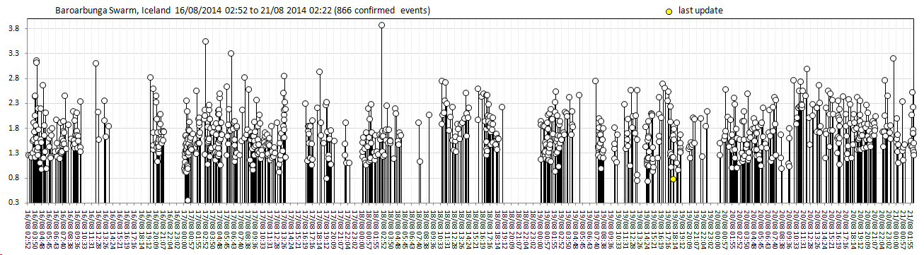
Notice this uplift in Grimsfjall/Grimsvötn GPS data. There was 3.0 quake detected in middle of that quake swarm, there hasn't been other 3,0+ for 48
hours. The amount of 2-3M quakes has increased rapidly though. Now the quakes are rarely deeper than 10km. I tried to find information about
Barðarbunga lava dome, but I didn't find anything, I guess its mystery how deep it lies. Most quakes happen in the depth of 3-6km, though there are
some very shallow quakes at 1km.

edit on 20-8-2014 by Thebel because: (no reason given)
latest CONFIRMED events since that last map I did on the previous page, up
to 20/08/2014 16:54:07UTC, 159 events.
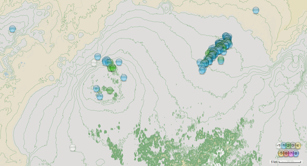
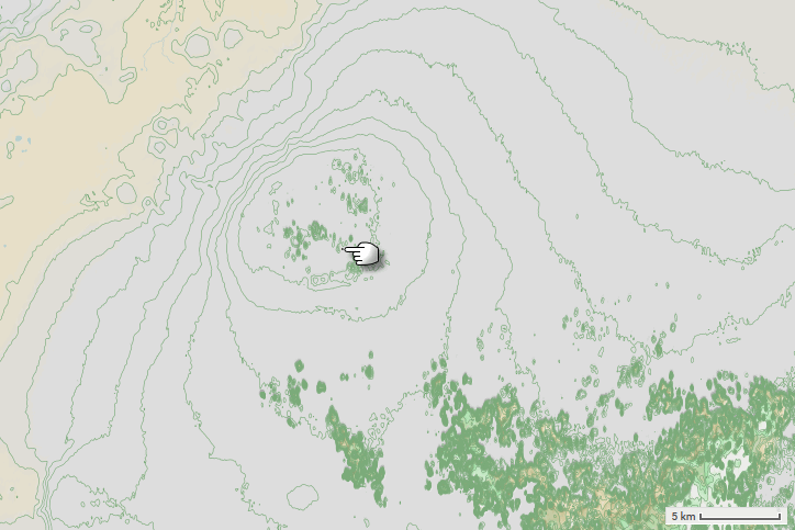
full size image
for those not familiar with the style of map the lines show the contours of the land under the ice.
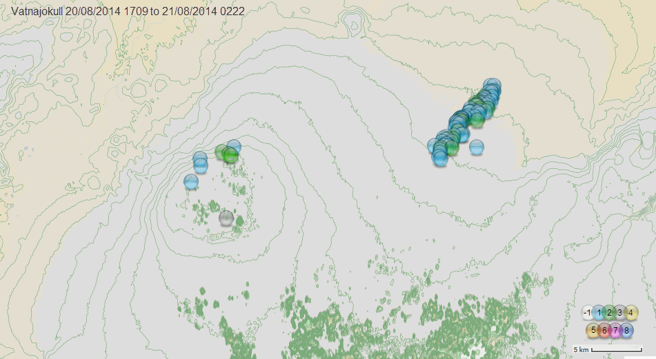
full size image
for those not familiar with the style of map the lines show the contours of the land under the ice.
edit on 0800000023123114 by muzzy because: (no reason given)
Baroarbunga, Vatnajokull latest confirmed events (to 21/08/2014 02:22)
Lat 64.2 to 65.0
Long -18 to -15
 click images for
larger version
click images for
larger version
Lat 64.2 to 65.0
Long -18 to -15


There seems to be 3 spots where the eruption could happen. Barðarbunga main caldera has some activity, recently 2 magnitude 3+ quakes, but the
activity is lower than in 2 other spots. Then this nameless spot between 2 other spots, where main activity seems to be. That will be a whole new
fissure if it erupts. Then lastly the Kistufell spot, which activity started much later than in other 2.
Other volcanoes in Vatnajökull are not active, thankfully. Kverkfjöll has some quakes, but may be just reflections from Kistufell. Grimsvötn is quiet, though its connected to Barðarbunga, as Grimsvörn eruption in 2011 halted the Barðarbunga activity.
Elsewhere in Iceland, The Katla still shows signs that eruption is coming sometime in the future. There are regular swarms of quakes, though only minor.
It's over or someone did some nasty cleaning at Icelandic Met office.
edit 1.
It was probably the cleaning lady messing up with the earthquake list. All red dots are back on the map now.
edit 1.
It was probably the cleaning lady messing up with the earthquake list. All red dots are back on the map now.
edit on 21-8-2014 by Nidwin because: (no reason given)
Wow, 2 strong earthquakes in Bárðarbunga caldera, first 4.0 of the swarm.


3D-presentation about quake locations:
(Depth is exaggerated 5 times to make quake locations more clear. The 3 planes are 10km, 5km and 0km under the sea level.)
3D-presentation about quake locations:
(Depth is exaggerated 5 times to make quake locations more clear. The 3 planes are 10km, 5km and 0km under the sea level.)
edit on 21-8-2014 by Thebel because: (no reason given)
I can't figure out how to upload an image.
Check this out, dont know when it will refresh!
vedur2.mogt.is...
Check this out, dont know when it will refresh!
vedur2.mogt.is...
originally posted by: berkeleygal
I can't figure out how to upload an image.
Check this out, dont know when it will refresh!
vedur2.mogt.is...
Is this the image you where trying to post?
Has anyone seen this yet?
www.aol.com...
A volcano in Japan could cause a tsunami if it erupts & collapses.
WOQ
www.aol.com...
A volcano in Japan could cause a tsunami if it erupts & collapses.
WOQ
OK, the raw Verdur SIL data is about 4 hours behind the earthquakes during
the last 48 hours (Preliminary results) page. You have to expect that when dealing with hundreds of quakes per hour.
But here is where things go wonky....
below is an example is the last one on my downloaded list of raw data, and matched with the preliminary entry on the 48 hour list
Preliminary off the 48 hour list
Date Time, Latitude, Longitude, Depth, Magnitude, Quality, Location
21/08/2014 06:30:24, 64.683, -16.967, 10.0 km, 2.6, 99%, 15.8 km SE of Kistufell
Raw data (reviewed)
21/08/2014 06:30:24, 64.6832, -16.96706 10.003, 2.27, 100%,
2.6 versus 2.27, quite a difference.
my expectation is that 4.0ML @ 21.08.2014 10:58:09, 64.670, -17.456, 3.1 km, 99%, 4.8 km NE of Bárðarbunga
will come down below 4
looking at the bigger picture ..........
the link to Iceland Aug 2014 on EQ Archives, I've fallen behind big time (like 9.5months!!) , mainly because the SIL data takes a ton of formatting to get the kml file right. I also decided in April 2013 to go from M1+ to ALL quakes, so there is still a lot of work to do there.
you will see Iceland 2013 on the dropdown list off Iceland at the top.
Quite an interesting site the IMO have, still finding stuff that I didn't know was there, everything has to be translated of course.
had a chuckle when I translated the text for the Tremors link, Órói hraun.vedur.is...
on the page itself the title translates as "Click on the red squares to see turmoil tomb"
and "turmoil grave" must be the archive hraun.vedur.is...
edit on 08u23223214 by muzzy because: (no reason given)
According to Jón Frímann, Bárðarbunga caldera seems to be collapsing. If that happens, the eruption will be very explosive event and ash cloud
will be huge. That will also change the landscape of Vatnajökull dramatically.
www.jonfr.com...
www.jonfr.com...
The thing that makes me nervous about this is that it could go several different ways with one of those possibilities being more or less benign for
humanity, and the longer it keeps rumbling, it seems the less likely a benign outcomes is. But, it could rumble for weeks before deciding to erupt,
too, and if it is just a displacement of magma, the more that moves, the longer it will be before it cools off enough to stop rumbling. So we could
wind up sitting on pins and needles ... waiting this out for quite a while.
M 4.8 - 117km WNW of Hofn, Iceland
DYFI? - I
Time
2014-08-21 18:50:22 UTC-05:00
Location
64.560°N 17.548°W
Depth
3.9km
earthquake.usgs.gov...
DYFI? - I
Time
2014-08-21 18:50:22 UTC-05:00
Location
64.560°N 17.548°W
Depth
3.9km
earthquake.usgs.gov...
Just saw this!
How far is it from the volcano???
4.8
117km WNW of Hofn, Iceland
2014-08-21 23:50:22 UTC
3.9 km
SOURCE: earthquake.usgs.gov...
WOQ
How far is it from the volcano???
4.8
117km WNW of Hofn, Iceland
2014-08-21 23:50:22 UTC
3.9 km
SOURCE: earthquake.usgs.gov...
WOQ
Let's wait for confirmation, on vedur it is listed as a 2.8
Update, it has been revised to a M3.3
Update, it has been revised to a M3.3
edit on 21-8-2014 by earthling42 because: (no reason given)
right under Barðarbunga, SW flank
IMO now showing
21.08.2014 23:50:20, 64.620, -17.459, 4.3 km, 4.7ML, 99.0 4.0 km SE of Bárðarbunga
on the 48 hr table
en.vedur.is...=table
right clic "view image" for larger version
IMO now showing
21.08.2014 23:50:20, 64.620, -17.459, 4.3 km, 4.7ML, 99.0 4.0 km SE of Bárðarbunga
on the 48 hr table
en.vedur.is...=table
edit on 08u23223214 by muzzy because: (no reason given)
right clic "view image" for larger version
edit on 08u23223214 by muzzy because: (no reason given)
They have revised it again, it was indeed an M4.7, and at the spot where other heavier quakes occurred earlier this day and yesterday.
If you click the link which i have posted earlier tonight, you can see the 3D view.
If you click the link which i have posted earlier tonight, you can see the 3D view.
new topics
-
The functionality of boldening and italics is clunky and no post char limit warning?
ATS Freshman's Forum: 30 minutes ago -
Meadows, Giuliani Among 11 Indicted in Arizona in Latest 2020 Election Subversion Case
Mainstream News: 1 hours ago -
Massachusetts Drag Queen Leads Young Kids in Free Palestine Chant
Social Issues and Civil Unrest: 1 hours ago -
Weinstein's conviction overturned
Mainstream News: 2 hours ago -
Supreme Court Oral Arguments 4.25.2024 - Are PRESIDENTS IMMUNE From Later Being Prosecuted.
Above Politics: 4 hours ago -
Krystalnacht on today's most elite Universities?
Social Issues and Civil Unrest: 4 hours ago -
Chris Christie Wishes Death Upon Trump and Ramaswamy
Politicians & People: 4 hours ago -
University of Texas Instantly Shuts Down Anti Israel Protests
Education and Media: 6 hours ago -
Any one suspicious of fever promotions events, major investor Goldman Sachs card only.
The Gray Area: 9 hours ago
top topics
-
VP's Secret Service agent brawls with other agents at Andrews
Mainstream News: 17 hours ago, 11 flags -
Krystalnacht on today's most elite Universities?
Social Issues and Civil Unrest: 4 hours ago, 8 flags -
Weinstein's conviction overturned
Mainstream News: 2 hours ago, 6 flags -
Supreme Court Oral Arguments 4.25.2024 - Are PRESIDENTS IMMUNE From Later Being Prosecuted.
Above Politics: 4 hours ago, 5 flags -
University of Texas Instantly Shuts Down Anti Israel Protests
Education and Media: 6 hours ago, 5 flags -
Electrical tricks for saving money
Education and Media: 16 hours ago, 5 flags -
Meadows, Giuliani Among 11 Indicted in Arizona in Latest 2020 Election Subversion Case
Mainstream News: 1 hours ago, 3 flags -
Any one suspicious of fever promotions events, major investor Goldman Sachs card only.
The Gray Area: 9 hours ago, 2 flags -
Massachusetts Drag Queen Leads Young Kids in Free Palestine Chant
Social Issues and Civil Unrest: 1 hours ago, 2 flags -
God's Righteousness is Greater than Our Wrath
Religion, Faith, And Theology: 13 hours ago, 1 flags
active topics
-
The functionality of boldening and italics is clunky and no post char limit warning?
ATS Freshman's Forum • 2 • : CarlLaFong -
Candidate TRUMP Now Has Crazy Judge JUAN MERCHAN After Him - The Stormy Daniels Hush-Money Case.
Political Conspiracies • 761 • : Threadbarer -
Weinstein's conviction overturned
Mainstream News • 18 • : nugget1 -
University of Texas Instantly Shuts Down Anti Israel Protests
Education and Media • 158 • : Threadbarer -
-@TH3WH17ERABB17- -Q- ---TIME TO SHOW THE WORLD--- -Part- --44--
Dissecting Disinformation • 675 • : Thoughtful3 -
Meadows, Giuliani Among 11 Indicted in Arizona in Latest 2020 Election Subversion Case
Mainstream News • 3 • : network dude -
Any one suspicious of fever promotions events, major investor Goldman Sachs card only.
The Gray Area • 9 • : xuenchen -
President BIDEN Vows to Make Americans Pay More Federal Taxes in 2025 - Political Suicide.
2024 Elections • 145 • : ImagoDei -
Massachusetts Drag Queen Leads Young Kids in Free Palestine Chant
Social Issues and Civil Unrest • 7 • : nugget1 -
Nearly 70% Of Americans Want Talks To End War In Ukraine
Political Issues • 86 • : Consvoli