It looks like you're using an Ad Blocker.
Please white-list or disable AboveTopSecret.com in your ad-blocking tool.
Thank you.
Some features of ATS will be disabled while you continue to use an ad-blocker.

Volcano Watch 2014
page: 58share:
holuhraun november 2014 footage on vimeo
edit on Mondaypm101430Mon, 10 Nov 2014 15:38:28 -0600382014-11-10T15:38:28-06:00k by LadyTrick because: (no reason given)
The iceland uni tweeted that bardarbunga crater GPS has been moved/lifted due to it almost being covered in snowfall. So nobody panic (like I did)
when you see the huge rise on the graph.
Apologies to those who pop into my Volcanic Tremors Blog for their daily dose of Bardarbunga interactive maps and graphs, I got 4 days behind.
have got a paper project going on for work so haven't had the time to do the earthquake stuff.
Luckily IMO keep an archive so the data is always there to go back and use. Only extra work is weeding out the earthquake outside the Vatnajokull area. which isn't a major.
I have done the back mapping for the 4 days, and the TimevsMag graph, I'll get to the depth and caldera stuff when I finish my work project.
volcanictremor.wordpress.com...
Also taking up my spare time is the Google Maps crisis
Tell me, do any of you see this message on my maps?
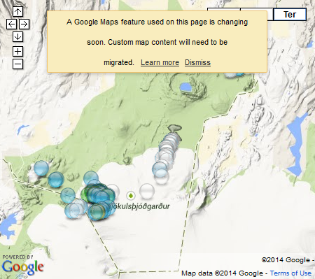
Its on all my maps, NZEQ, EQArchives and SignificantEQ, basically anywhere I have used Google Maps
Seems after Feb 2015 these maps will not show the information in the popup tags when you click on the icons and may not even show the icons either!
I have been surfing the Help and the Google Forums but can't get an answer as to how badly this change will effect the work I have done. Big disappointment if the above happens, 8 years worth of work down the drain.
Change for the sake of what?
I am studying OpenStreetMaps system to see if I can use that instead, not quite the same, but you can't just walk away from 8 years worth of archiving.
have got a paper project going on for work so haven't had the time to do the earthquake stuff.
Luckily IMO keep an archive so the data is always there to go back and use. Only extra work is weeding out the earthquake outside the Vatnajokull area. which isn't a major.
I have done the back mapping for the 4 days, and the TimevsMag graph, I'll get to the depth and caldera stuff when I finish my work project.
volcanictremor.wordpress.com...
Also taking up my spare time is the Google Maps crisis
Tell me, do any of you see this message on my maps?
Its on all my maps, NZEQ, EQArchives and SignificantEQ, basically anywhere I have used Google Maps
Seems after Feb 2015 these maps will not show the information in the popup tags when you click on the icons and may not even show the icons either!
I have been surfing the Help and the Google Forums but can't get an answer as to how badly this change will effect the work I have done. Big disappointment if the above happens, 8 years worth of work down the drain.
Change for the sake of what?
I am studying OpenStreetMaps system to see if I can use that instead, not quite the same, but you can't just walk away from 8 years worth of archiving.
abcnews.go.com...
"Mt. Pavlov in Alaska is acting up.
One of Alaska's most active volcanos has calmed down since spewing ash up to 35,000 feet into the air over the weekend, but scientists said Monday the volcano has a pattern of prolonged eruptions of varying intensity. They're not ready to consider this explosion over.
Pavlof Volcano began erupting Wednesday, culminating with a major blast Saturday that lasted seven or eight hours before its seismic activity dramatically dropped.
The National Weather Service warned aircraft to avoid the area over the weekend because of the ash plume."
hopefully this one is done for awhile.
further to post by: me above
Depth Graphs are on. Caldera graphs and Caldera Maps to come.
Bit of an uptick since the 13th right across the area, the Holuhraun lava field and the Dyngjujokull glacier SW of the eruption was getting pretty quiet prior to the 13th
I wonder if this was a recharge of lava?
Link in post above.
Depth Graphs are on. Caldera graphs and Caldera Maps to come.
Bit of an uptick since the 13th right across the area, the Holuhraun lava field and the Dyngjujokull glacier SW of the eruption was getting pretty quiet prior to the 13th
I wonder if this was a recharge of lava?
Link in post above.
All up to date now.
Changed to MyMaps, due to proposed crash of Classic Maps in Feb 2015.
Been an uptick in number of quakes, although energy released has been steady
can see it on the graphs here
been 5 days since a M5
Caldera showing a heck of a lot of M3's, which is interesting, as in the first 2 months of this there were never large numbers of M3's, caldera maps here
I feel an updated animation coming on, have gathered enough new maps since the end of the last one (Oct23) to justify the time to make a new one.
Just to keep the topic alive.
Bardarbunga-Holuhraun
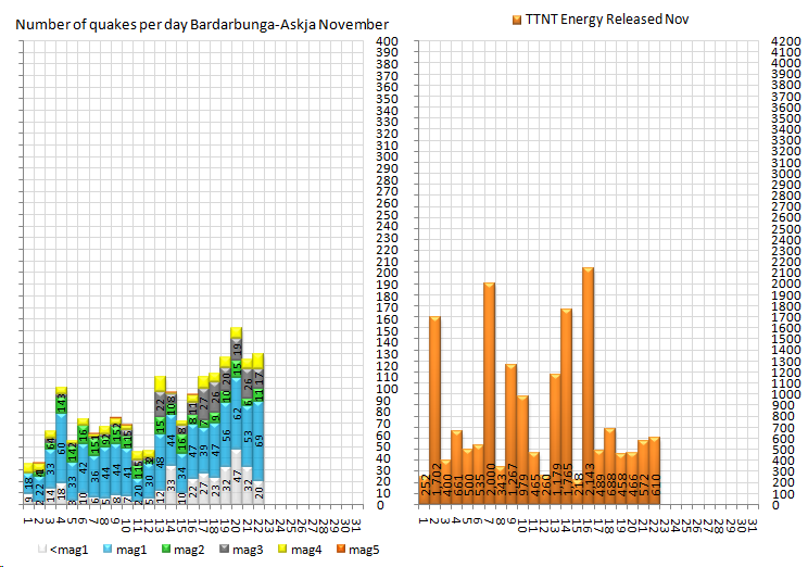
Yesterday summary (22nd)
magless1= 20 , mag1= 69 , mag2= 11 , mag3= 17 , mag4= 13 , mag5= 0
total= 130 , total energy released= 609.9917 TTNT
November Summary to end of 22nd
magless1= 347 , mag1= 922 , mag2= 225
mag3= 211 , mag4= 147 , mag5= 6
total= 1,858, total energy released= 17,952.030 TTNT
rightclick"viewimage"forfullsize
Bardarbunga-Holuhraun
Yesterday summary (22nd)
magless1= 20 , mag1= 69 , mag2= 11 , mag3= 17 , mag4= 13 , mag5= 0
total= 130 , total energy released= 609.9917 TTNT
November Summary to end of 22nd
magless1= 347 , mag1= 922 , mag2= 225
mag3= 211 , mag4= 147 , mag5= 6
total= 1,858, total energy released= 17,952.030 TTNT
rightclick"viewimage"forfullsize
earthice.hi.is...
The volcanic eruption in Holuhraun continues to be strong. The activity is similar as it has been for the last two weeks but the lava flow is more fluctuating. The lava flow forms an extrusion to the east southeast. From mid-September the productivity of the eruption has decreased.
Holuhraun
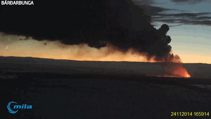
Sort of gave up on the web cams through November, last screenshots I got were 06/11, been black or else nothing to see due to snow/fog/rain ect
Happened to have a look this morning (sunset there), reasonably clear
spotted the Moon, then made a short animation of the eruption and the Moon going down (on left hand side)
Animation starts when the date is shown, then loops
rightclick"viewimage"forfullsize
edit on 11u32732714 by muzzy because: (no reason given)
originally posted by: muzzy
All up to date now.
Changed to MyMaps, due to proposed crash of Classic Maps in Feb 2015.
MyMaps is a disaster, it can't even cope with 169 events per day.
I've had to dump the interactive maps and replace it with a static image.
Still give an overview of what happened at Bardarbunga-Holuhraun, and there is still the depth graphs too to check whats what.
Pisses me off, after 3 months work following this, Google screwed it up by changing the system.
see what you think of my new layout
23/11/2014
edit on 11u32732714 by muzzy because: (no reason given)
Cape Verde residents evacuated as Pico do Fogo volcano erupts
bbc
bbc
A volcano has erupted in the Cape Verde islands, causing hundreds of residents living in the vicinity to be evacuated and a local airport to be closed.
A large plume of smoke was seen rising over the Pico do Fogo volcano, starting on Sunday.
It is the first time the volcano on the island of Fogo has erupted since 1995.
Mount Aso volcano belches smoke and ash
Source
Video : Japan's largest volcano spews smoke and lava
Link
A huge volcano in southern Japan was belching smoke and ash 1,000 meters (3,000 feet) into the air on Wednesday, the latest eruption in one of the world’s most volcanically active countries.
The eruption is Aso’s first in 19 years and comes two months after Mount Ontake in Nagano killed more than 60 hikers when it erupted without warning.
Source
Video : Japan's largest volcano spews smoke and lava
Link
Just out of sheer silliness. Has anyone compared the recent activity with chart of lay lines?
a reply to: muzzy
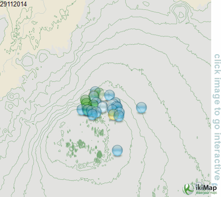
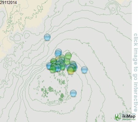
In fact when using ikimaps instead of Google, each map gets more views there than my blog itself
for example the map for 24/11/2014 got 4 views on the blog, and 19 on the ikimap site
using OSM as the background takes a bit of getting used to, and the base map on ikimaps automatically zooms to the full extent of the overall activity, so at that zoom level you don't get the topo line contours like on the static image, the only way to do that would be to restrict the data to a smaller box, which sort of defeats the purpose ie Bardarbunga-Holuhraun coverage, not just Bardarbunga
Conclusions of the Scientific Advisory Board of the Icelandic Civil Protection:
No signal is coming from the GPS station in the Bardarbunga caldera, the most likely explanation is that the subsidence of the caldera is so great that the GPS station is now below the caldera rim and is therefore out of sight of the relay station in Kverkfjoll.
Wow!
-25metres
hraun.vedur.is...
No signal is coming from the GPS station in the Bardarbunga caldera, the most likely explanation is that the subsidence of the caldera is so great that the GPS station is now below the caldera rim and is therefore out of sight of the relay station in Kverkfjoll.
Wow!
-25metres
hraun.vedur.is...
quiet day at the Vatnajokull, all at Bardarbunga, nothing at the Holuhraun lava field or in between, could be because I was in early for the data,
dumped 30 events becasue they were below 90.01% quality, may be more creep up into the map tomorrow.
mag ~1= 3 , mag1= 19 , mag2= 6 , mag3= 0 , mag4= 2 , mag5= 0
total= 30 , total energy released= 103.1891 TTNT
go ahead click it, it works!
finger to google
mag ~1= 3 , mag1= 19 , mag2= 6 , mag3= 0 , mag4= 2 , mag5= 0
total= 30 , total energy released= 103.1891 TTNT
go ahead click it, it works!
finger to google
a reply to: muzzy
Muzzy, you do realize that a lot of people just like me hardly ever click on the maps because the ones here are fine?
Just for when you think no one looks, we do, it's just the ones here are plenty big enough.
However, you asked me to, so I clicked this one.
It works.
P
Muzzy, you do realize that a lot of people just like me hardly ever click on the maps because the ones here are fine?
Just for when you think no one looks, we do, it's just the ones here are plenty big enough.
However, you asked me to, so I clicked this one.
It works.
P
Thanks pheonix, that makes you 1/17 that looked at it already. I think I'll get more viewers on ikimaps than either ATS or my blog, possibly because
its based in Spain. Euro's will be interested more in what is happening there.
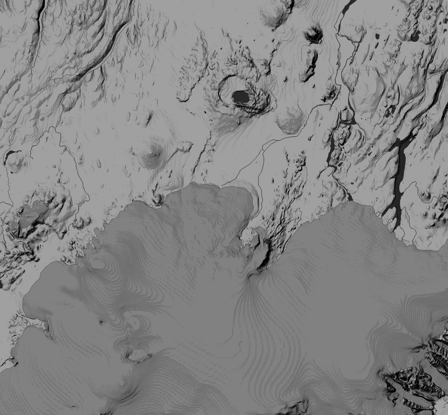
Heres another map I was playing around with, always been frustrated by that damn ice on top of the volcano, managed to play around with some filters on a topo map from World Topo 4U, not sure where it comes, from looks like OSM type of map.
But you can see how massive Bardarbunga really is ( most of the dark grey area)
right click "view image" for full size
originally posted by: muzzy
quiet day at the Vatnajokull, all at Bardarbunga, nothing at the Holuhraun lava field or in between, could be because I was in early for the data, dumped 30 events becasue they were below 90.01% quality, may be more creep up into the map tomorrow.
mag ~1= 3 , mag1= 19 , mag2= 6 , mag3= 0 , mag4= 2 , mag5= 0,
total= 30 , total energy released= 103.1891 TTNT
go ahead click it, it works!
finger to google
Yeah another 9 earthquakes when downloaded the data today approx. 17hrs later, all 99% quality.
Maybe I should wait, will save a lot of re-posting.
mag~1= 1 , mag1= 20 , mag2= 16 , mag3= 0 , mag4= 2 , mag5= 0 ,
total= 39 , total energy released= 103.9986 TTNT
new map
There appears to be less weak quakes, but there is rather windy so wind noise prevents detecting them. The gps sensor on the caldera has subsided
below the caldera rim, which prevents the signal reception to relay station. But looking the other gps sensors around, the deformation is still
ongoing. I expect this to continue for a long time, if there is no eruption, it can go for months. Looking the deformation, seems like the new
exciting thing would be inflation of Kverkfjöll:

You can clearly see the inflation in this 1-year graph. Historical eruptions of Kverkfjöll have originated from Bardarbunga. Last eruption of Kverkfjöll was in 1968, before that in 1959 and 1929.

You can clearly see the inflation in this 1-year graph. Historical eruptions of Kverkfjöll have originated from Bardarbunga. Last eruption of Kverkfjöll was in 1968, before that in 1959 and 1929.
edit on 1-12-2014 by Thebel because: (no reason given)
new topics
-
Electrical tricks for saving money
Education and Media: 2 minutes ago -
VP's Secret Service agent brawls with other agents at Andrews
Mainstream News: 1 hours ago -
Sunak spinning the sickness figures
Other Current Events: 2 hours ago -
Nearly 70% Of Americans Want Talks To End War In Ukraine
Political Issues: 2 hours ago -
Late Night with the Devil - a really good unusual modern horror film.
Movies: 4 hours ago -
Cats Used as Live Bait to Train Ferocious Pitbulls in Illegal NYC Dogfighting
Social Issues and Civil Unrest: 5 hours ago -
The Good News According to Jesus - Episode 1
Religion, Faith, And Theology: 7 hours ago -
HORRIBLE !! Russian Soldier Drinking Own Urine To Survive In Battle
World War Three: 9 hours ago
top topics
-
SETI chief says US has no evidence for alien technology. 'And we never have'
Aliens and UFOs: 16 hours ago, 8 flags -
Florida man's trip overseas ends in shock over $143,000 T-Mobile phone bill
Social Issues and Civil Unrest: 12 hours ago, 8 flags -
Cats Used as Live Bait to Train Ferocious Pitbulls in Illegal NYC Dogfighting
Social Issues and Civil Unrest: 5 hours ago, 7 flags -
VP's Secret Service agent brawls with other agents at Andrews
Mainstream News: 1 hours ago, 6 flags -
Former Labour minister Frank Field dies aged 81
People: 14 hours ago, 4 flags -
Bobiverse
Fantasy & Science Fiction: 12 hours ago, 3 flags -
HORRIBLE !! Russian Soldier Drinking Own Urine To Survive In Battle
World War Three: 9 hours ago, 3 flags -
Nearly 70% Of Americans Want Talks To End War In Ukraine
Political Issues: 2 hours ago, 3 flags -
Sunak spinning the sickness figures
Other Current Events: 2 hours ago, 3 flags -
Late Night with the Devil - a really good unusual modern horror film.
Movies: 4 hours ago, 2 flags
active topics
-
Electrical tricks for saving money
Education and Media • 0 • : annonentity -
Late Night with the Devil - a really good unusual modern horror film.
Movies • 4 • : DBCowboy -
Hate makes for strange bedfellows
US Political Madness • 41 • : Solvedit -
Nearly 70% Of Americans Want Talks To End War In Ukraine
Political Issues • 11 • : DBCowboy -
SETI chief says US has no evidence for alien technology. 'And we never have'
Aliens and UFOs • 40 • : Irishhaf -
President BIDEN Vows to Make Americans Pay More Federal Taxes in 2025 - Political Suicide.
2024 Elections • 124 • : Justoneman -
Ditching physical money
History • 20 • : GENERAL EYES -
Sunak spinning the sickness figures
Other Current Events • 3 • : NoCorruptionAllowed -
VP's Secret Service agent brawls with other agents at Andrews
Mainstream News • 13 • : DAVID64 -
The Reality of the Laser
Military Projects • 42 • : Zaphod58