It looks like you're using an Ad Blocker.
Please white-list or disable AboveTopSecret.com in your ad-blocking tool.
Thank you.
Some features of ATS will be disabled while you continue to use an ad-blocker.

Volcano Watch 2014
page: 54share:
quite the cone buildup
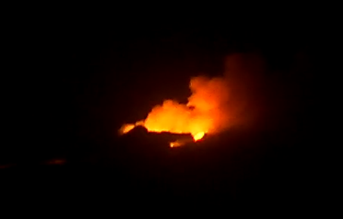
I think its time for another flyover, to see whats up at the fissure itself
I think its time for another flyover, to see whats up at the fissure itself
Has anyone else noticed that the Bardarbunga caldera drop graph hasn't been updated in 18 hours? The graph they are displaying is the same one from
18 hours ago. It looked like a steady increased drop before they stopped updating it.
hraun.vedur.is...
Also I saw two tornadoes, real tornadoes not dust devils, on the left side of the web cam near all of the steam that is being produced by the lava meeting the river. One of them was pretty big. There was a lot of black volcanic dust in it. The entire sky was rotating. These two tornados were coming down from the left side of the rotating clouds.
edit on 3-10-2014 by Adaluncatif because: punctuation and spelling
originally posted by: Adaluncatif
Has anyone else noticed that the Bardarbunga caldera drop graph hasn't been updated in 18 hours? The graph they are displaying is the same one from 18 hours ago. It looked like a steady increased drop before they stopped updating it.
hraun.vedur.is...
Also I saw two tornadoes, real tornadoes not dust devils, on the left side of the web cam near all of the steam that is being produced by the lava meeting the river. One of them was pretty big. There was a lot of black volcanic dust in it. The entire sky was rotating. These two tornados were coming down from the left side of the rotating clouds.
The bottom graph that shows several days is updated. I don't know why they are not updating the top graph for the 48 hour period. You can see the latest data by looking at the bottom graph, but it is really tiny to see.
a reply to: Adaluncatif
it has been updated at 03/10/2014 17:30 (current view)
I guess we all assume these things are done automatically, but maybe they are not and require analysis and creation by humans
I keep looking for the reports from the Scientists from the Icelandic Met Office and the Institute of Earth Sciences earthice.hi.is... often they are days behind, then all of a sudden the reports appear for 2 days back.
I guess they have other things to do
edit: new image @ 17:50, so maybe it is automatic after all, just was broken.
it has been updated at 03/10/2014 17:30 (current view)
I guess we all assume these things are done automatically, but maybe they are not and require analysis and creation by humans
I keep looking for the reports from the Scientists from the Icelandic Met Office and the Institute of Earth Sciences earthice.hi.is... often they are days behind, then all of a sudden the reports appear for 2 days back.
I guess they have other things to do
From today, the Scientific Advisory Board will meet on Mondays, Wednesdays and Fridays. The next meeting will be held on Monday 6 October.
edit on 1000000027527514 by muzzy because: (no reason given)
edit: new image @ 17:50, so maybe it is automatic after all, just was broken.
edit on 1000000027527514 by muzzy because: (no reason
given)
last night I finally figured out how to get timed screenshots off the web cams using Snagit. It required I change some settings on my computer, such
as turning off sleep and screensaver, took a few attempts to get it right.
I set it for every 15 minutes and it sets the time stamp on the border (NZDT)
It works well.
But the weather came in while I was asleep and there isn't much to see on the images.
Murphy's Law
Oh well, its ready for when the weather clears, hopefully can get some good shots at sunset
I set it for every 15 minutes and it sets the time stamp on the border (NZDT)
It works well.
But the weather came in while I was asleep and there isn't much to see on the images.
Murphy's Law
Oh well, its ready for when the weather clears, hopefully can get some good shots at sunset
edit on 10u27527514 by muzzy because: (no reason
given)
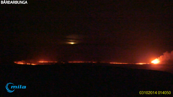
a reply to: muzzy
yes what you see in that web cam image is the new "Baugar" cone
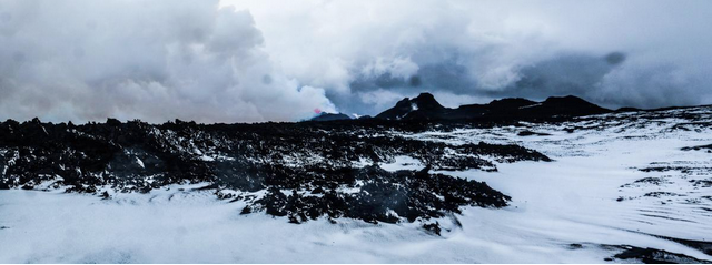
Photo from Robert Alexander Askew, taken 2. October
earthice.hi.is...
yes what you see in that web cam image is the new "Baugar" cone
Photo from Robert Alexander Askew, taken 2. October
earthice.hi.is...
edit on 1000000027527514 by muzzy because: (no reason given)
from my EQ Archives Iceland for September 2014. Reviewed data.
Earthquakes above M4 are "M" magnitude Type, those below are ML Type. I'm not sure how this works out, as I have done 2 years worth of monthly maps based on ML alone, this compromises consistency.
If I used only ML for Sept there would be no quakes above 5.0ML!!!
But going with 4+ reduces the number of 3ML's.
Not sure how IMO define preliminary versus reviewed when they write about the number of quakes based on size.
Must go back and check what I did for August.
interactive map centred on Bardarbunga-Holuhraun
Summary
mag less than1= 2290 , mag1= 1755 , mag2= 275 , mag3= 11 , mag4= 56 , mag5= 27
total= 4414 , total energy released= 43,326.8270 TTNT
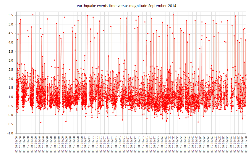
right click "view image" for full size (hopefully)
Earthquakes above M4 are "M" magnitude Type, those below are ML Type. I'm not sure how this works out, as I have done 2 years worth of monthly maps based on ML alone, this compromises consistency.
If I used only ML for Sept there would be no quakes above 5.0ML!!!
But going with 4+ reduces the number of 3ML's.
Not sure how IMO define preliminary versus reviewed when they write about the number of quakes based on size.
Must go back and check what I did for August.
interactive map centred on Bardarbunga-Holuhraun
Summary
mag less than1= 2290 , mag1= 1755 , mag2= 275 , mag3= 11 , mag4= 56 , mag5= 27
total= 4414 , total energy released= 43,326.8270 TTNT
right click "view image" for full size (hopefully)
edit on 10u27527514 by muzzy because: (no reason given)
is that R2D2 over on Dyngjujokull glacier?
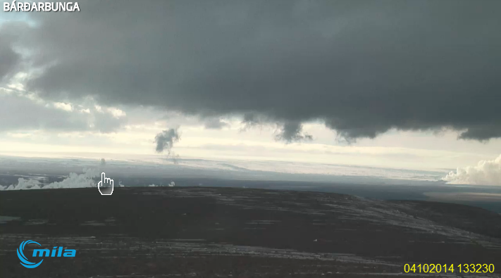
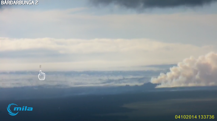
or a speck on the camera lense?
both cameras?
or a speck on the camera lense?
both cameras?
Bardarbunga-Holuhraun
looks like the weather is coming down again at dusk.
I managed to get quite a few screenshots for Friday when I was away from home using the Snagit programme with the timer, a lot looked the same so I just selected those that looked like there had been a change, still got 31 of them
images 03/10/2014 quite a few night shots which I don't normally bother with.
Similar situation last night but deleted a lot when the rain/snow/fog came in, will post those at the end of the day (Iceland time)
Snagit works great, but because it only grabs jpg/png/gif images directly from the web page address it won't grab the live video. So I have to have the page open when the timer is doing the screenshoting, i.e. leave it on when I'm not here.
It doesn't work so well when I'm here doing other things on the laptop as it grabs the active screen, i.e maybe the Excel spreadsheet I'm using at the time. So I have to do it manually. AT least I have it set to just take the image in the centre panel and don't have to crop a full page screenshot later.
edit on 10u27627614 by muzzy because: missed a ] in the tags
edit on 1000000027627614 by muzzy because: added title, there are
other volcanos going off too .....
The activity in Bardarbunga is really high right now, there are a lot earthquakes stronger than magnitude 3, and the subsidence of the caldera is very
rapid. The focus of the quakes is in northern rim of the caldera.

a reply to: Thebel
I wonder if the caldera roof is collapsing evenly into the center, like it was at 08/09/2014?
or to one side (to the north)?
That is the last survey map published by the Institute of Earth Sciences
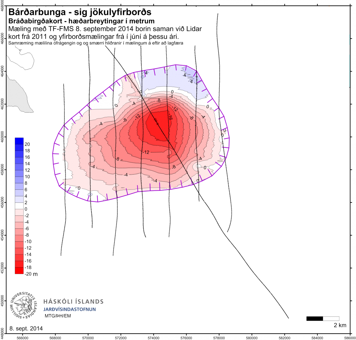
earthice.hi.is...
time for a new survey map!
I wonder if the caldera roof is collapsing evenly into the center, like it was at 08/09/2014?
or to one side (to the north)?
That is the last survey map published by the Institute of Earth Sciences
earthice.hi.is...
time for a new survey map!
edit on 10u27727714 by muzzy because: add link
The total subsidence of the caldera is now 32 meters.
The activity has increased a lot over the past days, i really think an eruption of Bardarbunga itself in the coming months is very likely to happen.
A beautiful video, although the title is wrong, this eruption is not at Bardarbunga but at Holuhraun.
The activity has increased a lot over the past days, i really think an eruption of Bardarbunga itself in the coming months is very likely to happen.
A beautiful video, although the title is wrong, this eruption is not at Bardarbunga but at Holuhraun.
There are so many deep quakes in Bardarbunga right now, new magma coming from mantle? The activity has increased a lot during these 2 days. Smaller
earthquakes don't get even registered because the weather is really windy again.
Notes from the meeting of the Scientific Advisory Board (pdf)
Notes from the meeting of the Scientific Advisory Board (pdf)
I am going to make a prediction that the main Bardarbunga volcano will erupt on Halloween, plus or minus three days. I believe that the caldera will
have fallen so much that the whole thing will give way causing the glacier above to collapse into the magma chamber causing a tremendous explosion.
It is possible that much of the ice will be thrown out before vaporizing or melting. Luckily, I don't think the area is populated. Ice chunks could
be as big as houses.
Wow, 5.5 magnitude quake within the caldera, and there has been huge drops today, just look at this:

If current trend continues, the caldera will no longer have support and it will collapse within 2 weeks. I predict that the northern rim of the caldera will collapse, maybe the whole northern part will collapse, as the quake activity is mainly there. There is really dangerous to be there when that happens.
The earthquakes show more dispersion too, they no longer occupy just northern rim, they are all over the caldera, but still most in north.
edit on 7-10-2014 by Thebel because: (no reason given)
it will be less epic than krakatau if the gletger falls in it but never the less ..it will be an bigggg bang
p/s soundwaves of krakatau rolled over the whole world
p/s soundwaves of krakatau rolled over the whole world
Despite Bardarbunga-Holuhraun dominating the discussions this last few months, I still get a couple of hits a day on my Yellowstone pages,
what are they looking for I wonder?
maps? graphs?
well if either of those, here is YS 2014 brought up to date, I was 9 months behind
YS 2014
all the action seems to be happening around Grizzly Lake this year
what are they looking for I wonder?
maps? graphs?
well if either of those, here is YS 2014 brought up to date, I was 9 months behind
YS 2014
all the action seems to be happening around Grizzly Lake this year
a reply to: muzzy
Maybe this.
www.abovetopsecret.com...
Has some people worried.
P
I still get a couple of hits a day on my Yellowstone pages, what are they looking for I wonder?
Maybe this.
www.abovetopsecret.com...
Has some people worried.
P
new topics
-
Hello from burritocat
Introductions: 3 minutes ago -
An Apology From the Dunderbeck Sausage Company
Music: 2 hours ago -
Tucker on Joe Rogan talking Kona Blue and UFOs
Aliens and UFOs: 2 hours ago -
Remember These Attacks When President Trump 2.0 Retribution-Justice Commences.
2024 Elections: 3 hours ago -
Predicting The Future: The Satanic Temple v. Florida
Conspiracies in Religions: 3 hours ago -
WF Killer Patents & Secret Science Vol. 1 | Free Energy & Anti-Gravity Cover-Ups
General Conspiracies: 5 hours ago -
Hurt my hip; should I go see a Doctor
General Chit Chat: 6 hours ago -
Israel attacking Iran again.
Middle East Issues: 7 hours ago -
Michigan school district cancels lesson on gender identity and pronouns after backlash
Education and Media: 7 hours ago -
When an Angel gets his or her wings
Religion, Faith, And Theology: 8 hours ago
top topics
-
The Democrats Take Control the House - Look what happened while you were sleeping
US Political Madness: 13 hours ago, 18 flags -
In an Historic First, In N Out Burger Permanently Closes a Location
Mainstream News: 15 hours ago, 16 flags -
Biden says little kids flip him the bird all the time.
Politicians & People: 13 hours ago, 9 flags -
Man sets himself on fire outside Donald Trump trial
Mainstream News: 13 hours ago, 9 flags -
Michigan school district cancels lesson on gender identity and pronouns after backlash
Education and Media: 7 hours ago, 8 flags -
WF Killer Patents & Secret Science Vol. 1 | Free Energy & Anti-Gravity Cover-Ups
General Conspiracies: 5 hours ago, 7 flags -
Remember These Attacks When President Trump 2.0 Retribution-Justice Commences.
2024 Elections: 3 hours ago, 6 flags -
Pentagon acknowledges secret UFO project, the Kona Blue program | Vargas Reports
Aliens and UFOs: 10 hours ago, 6 flags -
Israel attacking Iran again.
Middle East Issues: 7 hours ago, 5 flags -
Boston Dynamics say Farewell to Atlas
Science & Technology: 10 hours ago, 4 flags
active topics
-
Israel attacking Iran again.
Middle East Issues • 34 • : 19Bones79 -
Hello from burritocat
Introductions • 0 • : burritocat -
The Democrats Take Control the House - Look what happened while you were sleeping
US Political Madness • 71 • : ImagoDei -
Remember These Attacks When President Trump 2.0 Retribution-Justice Commences.
2024 Elections • 15 • : ImagoDei -
Michigan school district cancels lesson on gender identity and pronouns after backlash
Education and Media • 11 • : Terpene -
A man of the people
Medical Issues & Conspiracies • 16 • : Astrocometus -
MULTIPLE SKYMASTER MESSAGES GOING OUT
World War Three • 57 • : SchrodingersRat -
Man sets himself on fire outside Donald Trump trial
Mainstream News • 45 • : ByeByeAmericanPie -
The Good News According to Jesus
Religion, Faith, And Theology • 4 • : randomuser2034 -
Are you ready for the return of Jesus Christ? Have you been cleansed by His blood?
Religion, Faith, And Theology • 22 • : glend