It looks like you're using an Ad Blocker.
Please white-list or disable AboveTopSecret.com in your ad-blocking tool.
Thank you.
Some features of ATS will be disabled while you continue to use an ad-blocker.

Volcano Watch 2014
page: 45share:
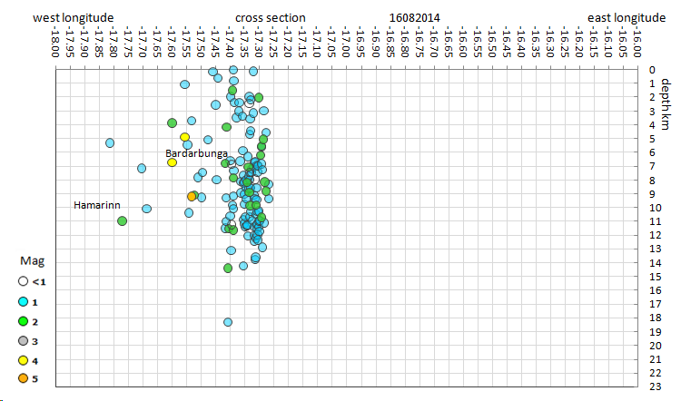
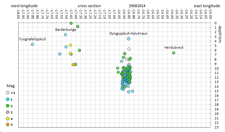
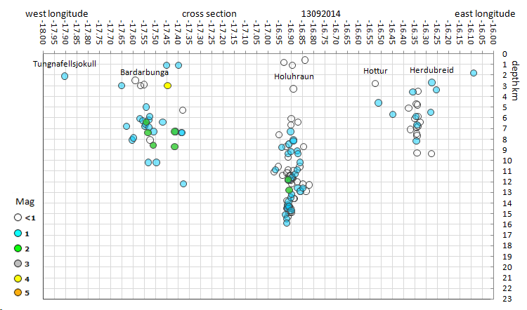
I did some longitude cross sections, at critical times along the way
16th Aug, the start of the seismicity
29th Aug, the day of the first small eruption
13th Sept, today
now to fill in the gaps ..............
some direct page links on ATS may be lost, as I am changing the name of each post from Bargarbunga to Bardarbunga, which appears is the most commonly used spelling, it may make a difference in the future for people searching for this event.
early morning blue colour on cam1 right now, just like yesterday
edit on 09u25625614 by muzzy because: (no reason given)
Jon Frimann has released an updated blogg today , which paints a potentially bleak outcome if Bardarbunga's caldera does completely collapse.
I understand he is a fairly well respected individual in vulcanism?
www.jonfr.com...
I understand he is a fairly well respected individual in vulcanism?
www.jonfr.com...
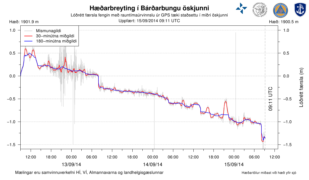
The subsidence is about 50 cm a day in the last two days.
Add this link to your favorites, real time monitoring of the subsidence of the Bardarbunga caldera.
Add this link to your favorites, real time monitoring of the subsidence of the Bardarbunga caldera.
originally posted by: logicalview
Jon Frimann has released an updated blogg today , which paints a potentially bleak outcome if Bardarbunga's caldera does completely collapse.
I understand he is a fairly well respected individual in vulcanism?
www.jonfr.com...
He isn't professional, but he is often right in his "predictions". He knows a lot from volcanism in Iceland.
Magnitude 5.3 earthquake, 5.8 km ENE from Bárðarbunga, 3.0km deep. Camera 2 is useless, but Camera 1 shows impressive smoke column.

Is that car next to "R2D2"? If it is, then "R2D2" is bigger than I thought.
another 5.3...on the caldera rim? ....:-(
tik tik tik.......
tik tik tik.......
edit on 14-9-2014 by ressiv because: (no reason given)
looks like web cam 2 has been repositioned, so it must be a separate camera!, not just a zoom in from the same cam 1.
the horizon is lower and seems zoomed back to a similar level as cam 1, but from a different angle
quite clear views right now
I like it, no more fuzzy cam2 pics!
mila cam 2 new
mila cam 1
the horizon is lower and seems zoomed back to a similar level as cam 1, but from a different angle
quite clear views right now
I like it, no more fuzzy cam2 pics!
mila cam 2 new
mila cam 1
No News by Moshpet???
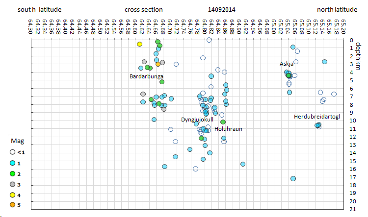
Interesting developments shown by the Lattitude Depth graph for yesterday. See Below
* Bold mine.
At the same time, if the earthquakes are anything to go, by the Dyngjujokull-Holuhraun swarm has returned back towards Bardarbunga and taken a deep dive
see graph below
compare with last few days
Interesting developments shown by the Lattitude Depth graph for yesterday. See Below
Daily status report 14. September 2014 - compiled by IMO (Icelandic Met Office) and IES (Institute of Earth Sciences)
The eruptive activity at Holuhraun continues at similar intensity. The lava flows at slower rates than it did yesterday.The lava is now spreading more to the sides and there is less visible activity in the eruptive craters.
The subsidence of the Bárðarbunga caldera continues and is now up to 23 meters.
Scientists flying over the area saw new tongues of lava breaking out from the main lava stream towards the east and west. The largest one of these lava tongues stretches towards the east and had become 300 m wide and 2 km long at 18:00 yesterday. An eruption cloud reaches 4 km in height but lowers with distance from the eruption site.
* Bold mine.
At the same time, if the earthquakes are anything to go, by the Dyngjujokull-Holuhraun swarm has returned back towards Bardarbunga and taken a deep dive
see graph below
compare with last few days
edit on 09u25725714 by muzzy because: (no
reason given)
originally posted by: logicalview
Jon Frimann has released an updated blogg today , which paints a potentially bleak outcome if Bardarbunga's caldera does completely collapse.
I understand he is a fairly well respected individual in vulcanism?
www.jonfr.com...
He is, especially when it comes to Icelandic vulcanism. But none knows what's going to happen and how small or big this event is going to evolve into.
I don't consider his opinion "bleak" as a lot of other scenarios are still possible. There are 4 other volcanos that could be impacted if the total collopase of the Bardarbunga caldera happen. Because of the Icecap on Vatna is very difficult to have a clear vision of what's going on down there and this makes for a lot of unknown and unpredictibale factors.
Let's wait and see, while hoping for the best.
Another magnitude 5.3 quake at Barðarbunga. Nothing on the IMO
Vatnajökull list yet.
USGS
EMSC
A correspondingly large drop of the GPS in the caldera happened at the same time.
Bardarðbunga GPS
USGS
EMSC
A correspondingly large drop of the GPS in the caldera happened at the same time.
Bardarðbunga GPS
a reply to: Nidwin
Yes, from what I've learned of the IMO system over the past few weeks, their automatic algorithms can't handle earthquakes over mag 4, because most of their seismometers are calibrated to detect smaller tremors.
So, at least for the moderate to strong quakes, we can expect quicker, and fairly accurate results from USGS, GEOFON, and EMSC using teleseismic data.
.......................................................
I need to make a comment. This is directed at no one in particular, it's just a peeve of mine.
[rant]
I've read too many comments (mostly on blogs) on the activity in Iceland, especially concerning the fissure eruption in Holuhraun, that mention "smoke" or "fire".
What people are actually seeing are volcanic gases and/or steam liberated from the glowing, hot molten rock.
Not fire. Nothing is burning. Therefore there is no smoke, because smoke is a product of combustion--and that isn't what is happening.
Even the term "volcanic ash" is misleading. It's actually pulverized rock. From USGS
Thank you for allowing my pedantic vent. I just don't want any of the great contributors here to be "that guy or gal"...
[/end rant]
Yes, from what I've learned of the IMO system over the past few weeks, their automatic algorithms can't handle earthquakes over mag 4, because most of their seismometers are calibrated to detect smaller tremors.
So, at least for the moderate to strong quakes, we can expect quicker, and fairly accurate results from USGS, GEOFON, and EMSC using teleseismic data.
.......................................................
I need to make a comment. This is directed at no one in particular, it's just a peeve of mine.
[rant]
I've read too many comments (mostly on blogs) on the activity in Iceland, especially concerning the fissure eruption in Holuhraun, that mention "smoke" or "fire".
What people are actually seeing are volcanic gases and/or steam liberated from the glowing, hot molten rock.
Not fire. Nothing is burning. Therefore there is no smoke, because smoke is a product of combustion--and that isn't what is happening.
Even the term "volcanic ash" is misleading. It's actually pulverized rock. From USGS
Volcanic ash is not the product of combustion, like the soft fluffy material created by burning wood, leaves, or paper.
Thank you for allowing my pedantic vent. I just don't want any of the great contributors here to be "that guy or gal"...
[/end rant]
edit on 9/15/2014 by Olivine because: (no reason given)
Is that a new fissure to the left of the main eruption?
Can't see it on earlier images of cam1 but a faint wisp of steam/gas on cam2 @ 17:57:15
this is cam 1 full screen cropped
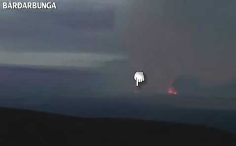
and can definitely see it now on cam 2 at 19:29:20
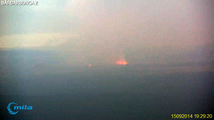
edit: yeah its definitely showing clearer on wcam1 now live
dusk is definitely the clearest time, seen the glacier quite clear earlier, must be the angle/reflection of the Sun off the snow.
edit2:
Wow, the lava flow along the ground is showing really clearly now at 8:21pm UTC (20:21)
Can't see it on earlier images of cam1 but a faint wisp of steam/gas on cam2 @ 17:57:15
this is cam 1 full screen cropped
and can definitely see it now on cam 2 at 19:29:20
edit on 0900000025725714 by muzzy because: (no reason given)
edit: yeah its definitely showing clearer on wcam1 now live
dusk is definitely the clearest time, seen the glacier quite clear earlier, must be the angle/reflection of the Sun off the snow.
edit on
0900000025725714 by muzzy because: (no reason given)
edit2:
Wow, the lava flow along the ground is showing really clearly now at 8:21pm UTC (20:21)
edit on 09u25725714 by muzzy because: (no reason
given)
Philippines Evacuates More Than 12,000 over Volcano Eruption Threat: Reports
Source
MOSCOW, September 16 (RIA Novosti) - More than 12,000 people have been forcibly evacuated in the Philippines as seismologists raise alert over the potential eruption of archipelago's most active volcano.
"We are now raising the alert status of Mayon Volcano from alert level 2 to 3," Renato Solidum, head of the Philippine Institute of Volcanology and Seismology (Phivolcs), said, as quoted by Reuters.
The volcano is located in the central Albay province on the Luzon Island, and has erupted at least 48 times since 1616.
Source
edit on 15-9-2014 by BornAgainAlien because: (no reason given)
a reply to: ressiv
not sure when you posted this one?
If it was the 5.4 @ 15/09/2014 08:04:58
Lat: 64.612 Long: -17.435
Magnitude: 5.4 ML
Depth: 0.1 km
all I can say is
geez thats shallow
100 metres!!!
how deep is the snow on the side of Bardarbunga I wonder?
my maps shows it right on the edge of the SW rim
not sure when you posted this one?
If it was the 5.4 @ 15/09/2014 08:04:58
Lat: 64.612 Long: -17.435
Magnitude: 5.4 ML
Depth: 0.1 km
all I can say is
geez thats shallow
100 metres!!!
how deep is the snow on the side of Bardarbunga I wonder?
my maps shows it right on the edge of the SW rim
Bardarbunga 15/09/2014 EQ Map and Time v Mag graph
some nice colours in the evening here web cams 15/09/2014
the Institute of Earth Sciences has nothing to say for the 15th, yet.
some nice colours in the evening here web cams 15/09/2014
the Institute of Earth Sciences has nothing to say for the 15th, yet.
a reply to: muzzy
I am taking a few days off due to rl.
My cousin rescued a person in mid-suicide, got them to the hospital in time and then was a nervous drek for several days later. (They survived, but it was one of his close friends....)
That and it seemed there was a day or so of not much changing news wise.
On top of that a wet surprise has pointed to a leaky roof.
I have tried to do the screen grabs as I remembered to to do them, among other crap.
Oh and there was a diatribe by someone, and I was trying to decide if it it was directed at us or if someone needed to go vent _elsewhere_. I am so not cut out to being the tactful, patient understanding type, when crap literally is falling out of the sky; or through the roof.
When it rains, it bloody pours.
M.
Just for Muzzy (Well that and I had a few spare moments over my coffee.)
Slid about 45 cm after the quake this morning
www.ruv.is...
Gosmengun as bad for animals and humans
www.ruv.is...
Advertise journeys into the closed area of the eruption
www.ruv.is...
M.
Photobucket link
s705.photobucket.com...
Slid about 45 cm after the quake this morning
www.ruv.is...
Vigorous shaking, 5.4 in size, became Bárðarbunga morning. According to the GPS device, which is in the midst Bárðarbunga cartons, carton slid by 20 inches when the quake was and another 25 centimeters over the next two to three hours after the quake.
This is the second earthquake of noon yesterday, which is over 5 size. About tvöleytið yesterday was shaking a size of 5.3 - showed that measurements of the box she was sunk by a few centimeters.
Gosmengun as bad for animals and humans
www.ruv.is...
Farmers in the areas where pollution from the eruption site, how could the greatest concern for the welfare of sheep still at ósmalað. Specialty Veterinarian with Food says pollution have the same irritating effect on animals and humans.
Advertise journeys into the closed area of the eruption
www.ruv.is...
The area around the eruption site in the hollow lava is still closed to all traffic. Irritability may at companies in the travel industry not being able to go with tourists into the area. There are examples of companies advertise that they can take with tourists in the volcanic area despite it being banned.
M.
Photobucket link
s705.photobucket.com...
edit on 16-9-2014 by Moshpet because: (no reason given)
edit on
16-9-2014 by Moshpet because: (no reason given)
A spectacular time-elapsed video of Bardarbunga's eruption beneath the Northern Lights.
www.wsj.com...
Northern Lights Appear Over Iceland's Bardarbunga
www.wsj.com...
new topics
-
Late Night with the Devil - a really good unusual modern horror film.
Movies: 21 minutes ago -
Cats Used as Live Bait to Train Ferocious Pitbulls in Illegal NYC Dogfighting
Social Issues and Civil Unrest: 1 hours ago -
The Good News According to Jesus - Episode 1
Religion, Faith, And Theology: 3 hours ago -
HORRIBLE !! Russian Soldier Drinking Own Urine To Survive In Battle
World War Three: 5 hours ago -
Bobiverse
Fantasy & Science Fiction: 8 hours ago -
Florida man's trip overseas ends in shock over $143,000 T-Mobile phone bill
Social Issues and Civil Unrest: 8 hours ago -
Former Labour minister Frank Field dies aged 81
People: 10 hours ago
top topics
-
President BIDEN Vows to Make Americans Pay More Federal Taxes in 2025 - Political Suicide.
2024 Elections: 17 hours ago, 19 flags -
Florida man's trip overseas ends in shock over $143,000 T-Mobile phone bill
Social Issues and Civil Unrest: 8 hours ago, 8 flags -
SETI chief says US has no evidence for alien technology. 'And we never have'
Aliens and UFOs: 12 hours ago, 7 flags -
This is our Story
General Entertainment: 15 hours ago, 4 flags -
Former Labour minister Frank Field dies aged 81
People: 10 hours ago, 4 flags -
Cats Used as Live Bait to Train Ferocious Pitbulls in Illegal NYC Dogfighting
Social Issues and Civil Unrest: 1 hours ago, 4 flags -
Bobiverse
Fantasy & Science Fiction: 8 hours ago, 3 flags -
HORRIBLE !! Russian Soldier Drinking Own Urine To Survive In Battle
World War Three: 5 hours ago, 2 flags -
Late Night with the Devil - a really good unusual modern horror film.
Movies: 21 minutes ago, 1 flags -
The Good News According to Jesus - Episode 1
Religion, Faith, And Theology: 3 hours ago, 0 flags
active topics
-
"We're All Hamas" Heard at Columbia University Protests
Social Issues and Civil Unrest • 278 • : KrustyKrab -
Silent Moments --In Memory of Beloved Member TDDA
Short Stories • 70 • : zosimov -
-@TH3WH17ERABB17- -Q- ---TIME TO SHOW THE WORLD--- -Part- --44--
Dissecting Disinformation • 650 • : angelchemuel -
Thousands Of Young Ukrainian Men Trying To Flee The Country To Avoid Conscription And The War
Other Current Events • 135 • : twistedpuppy -
President BIDEN Vows to Make Americans Pay More Federal Taxes in 2025 - Political Suicide.
2024 Elections • 89 • : DBCowboy -
Late Night with the Devil - a really good unusual modern horror film.
Movies • 0 • : devilhunter69 -
New whistleblower Jason Sands speaks on Twitter Spaces last night.
Aliens and UFOs • 52 • : 0bserver1 -
SETI chief says US has no evidence for alien technology. 'And we never have'
Aliens and UFOs • 33 • : 0bserver1 -
Mood Music Part VI
Music • 3099 • : BrucellaOrchitis -
HORRIBLE !! Russian Soldier Drinking Own Urine To Survive In Battle
World War Three • 20 • : budzprime69