It looks like you're using an Ad Blocker.
Please white-list or disable AboveTopSecret.com in your ad-blocking tool.
Thank you.
Some features of ATS will be disabled while you continue to use an ad-blocker.

Volcano Watch 2014
page: 40share:
Things are getting serious! Magnitude 5.5 quake just hit the Bárðarbunga caldera, at depth of 2.6km. That is not very deep. I believe that the
Bárðarbunga eruption is not very far.
Good view in both cams. Monitoring Cam2 is quite hard as there is really windy like now, the camera shakes like crazy. And its very laggy right now. The wind has turned from usual, the smoke plume is now going towards right.

And yes, that shaking is not earthquakes, its wind. Camera 2 is really badly fitted there, shaking all the time in wind.
Good view in both cams. Monitoring Cam2 is quite hard as there is really windy like now, the camera shakes like crazy. And its very laggy right now. The wind has turned from usual, the smoke plume is now going towards right.
And yes, that shaking is not earthquakes, its wind. Camera 2 is really badly fitted there, shaking all the time in wind.
Apparently, the sulfur smell has been noticed as far as Norway. The wind is bringing the sulfur towards Scandinavia. Here in Finland I haven't
noticed the smell of sulfur yet, but I inform when I notice that.
Norwegians smell sulfur from Holuhraun
Smell of sulfur gas thought to be from the Holuhraun eruption, has been detected at the west coast of Norway, some 1300 kilometres away (807 miles) according to Norsk Radio, the public broadcaster in Norway. Sattellite photos have shown migration of gasses in that direction.
In a story published today on NRK´s website, meteorologist Vibeke Thynes says the most likely source of the smell is the eruption in Iceland; she says the sulfur gas is highly diluted and not at all dangerous to the public.
RUV
Maybe I was just seeing things, and I have no screen shot because I'm on a stupid phone, but 20 minutes ago there was a very large white "steam"
column far in the distance on cam 1.
My best guess would be that it was near the toe of the glacier. I'm curious to read what this mornings over flight reports.
I'm hoping the higher winds today disperse the gases faster--giving the populations living with this eruption a break.
From the 11:55 update:
The IMO has dropped one of its scenarios. The one where seismic its and the fissure eruption just stop.
Update
My best guess would be that it was near the toe of the glacier. I'm curious to read what this mornings over flight reports.
I'm hoping the higher winds today disperse the gases faster--giving the populations living with this eruption a break.
From the 11:55 update:
Three scenarios are still considered most likely: Subsidence of the Bárðarbunga caldera stops and the eruption on Holuhraun declines gradually.
Large-scale subsidence of the caldera occurs, prolonging or strengthening the eruption on Holuhraun. In this situation, it is likely that the eruptive fissure would lengthen southwards under Dyngjujökull, resulting in a jökulhlaup and an ash-producing eruption. It is also possible that eruptive fissures could develop in another location under the glacier.
Large-scale subsidence of the caldera occurs, causing an eruption at the edge of the caldera. Such an eruption would melt large quantities of ice, leading to a major jökulhlaup. Other scenarios cannot be excluded.
The IMO has dropped one of its scenarios. The one where seismic its and the fissure eruption just stop.
Update
edit on 9/10/2014 by Olivine because: Add
update
edit on 9/10/2014 by Olivine because: Format for readability
a reply to: Olivine
That was nothing. You shoulda seen what happened when a bunch of huge dark clouds appeared to rise suddenly out from the steam over the glacier. I coulda sworn the entire place was gonna blow. But it was the clouds and a high contrast camera playing tricks.
The good news is I did seem to find a video that shows the recent subsidence of the Barda caldera:
I believe I see some exposed rock there, which would in effect invalidate my earlier theory- if there was not enough ice to cover the rock completely, the tensile strength argument is out.
a reply to: TrueAmerican
Hey TA, nice video.
What do you make of the tiny "glitch" looking activity at DYN?
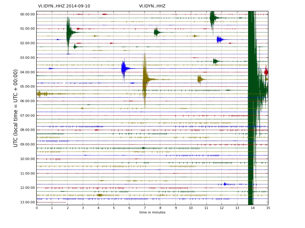
DYN seismograph
DYN tremor
Edit:
It's a shame Iceland Met isn't more open with their data--totally frustrating.
Hey TA, nice video.
What do you make of the tiny "glitch" looking activity at DYN?
DYN seismograph
DYN tremor
Edit:
It's a shame Iceland Met isn't more open with their data--totally frustrating.
edit on 9/10/2014 by Olivine because: (no reason
given)
a reply to: Olivine
DYN?
Well
1. Big quake miniaturizes those little ticks, so impossible to make out, and
2. Without spectro, couldn't tell ya. But real tremor is generally higher amplitude than that, and consistently thicker, so I doubt it. Plus, it would show up at VON, and it doesn't. Could be telemetry error.
3. Datahogs. Yes, agreed.
edit on Wed Sep 10th 2014 by TrueAmerican because: (no reason given)
Yesterday I had no cams most of the day, and now the wind is against me too. I swear it is a conspiracy or something!
Cam 1

Cam 2

And now all the news.
Gosmengun through the roof of the plant
www.ruv.is...
Aka the SO2 etc was too high, stay inside if you are frail.
Probably fewer opportunities in Bárðarbunga
(Likely fewer scenarios in Bardarbunga)
www.ruv.is...
First, it is considered possible to öskjusig in Bárðarbunga way before it becomes a huge and lava erupted in blowout fade out. Another possibility is a big öskjusig in Bárðarbunga eruption of lava pocket is long or wax. Possible to Fissure lengthened to the south, under Dyngjujökul and causing floods and ash fall. Also is possible that cracks open elsewhere under the glacier. Third, it is considered possible that the large öskjusig prices Bárðarbunga soda carton offense. Such a large eruption could melt ice and cause significant glacier run. Scientists say that it can not rule out other possibilities.
(My translation. The first two should be pronounced/heard in Leelu Dallas Multipass' voice. For Reference : www.youtube.com... )
1- Bard-dar-boom.
2- Big-Bar-dar-boom.
3- Bigger fissure eruption.
(Yes I had to go there.
Risks that do not transport corridors
www.ruv.is...
Evidently the farmers are trying to get rid of/butcher the sheep to avoid catastrophic losses in the event of major eruption.
I would posit that the people there more than a little 'concerned' about a big eruption, if they are moving to cull the herds early. If you like lamb as food, I suspect we'll see a price drop on imported kamb.
------------
Off the beaten track a bit, but relevant to the volcano:
In that one of the main causes of death in Iceland from the Laki eruption was starvation.... Due to the amount of fluorine in the soil/water/plants that killed off the livestock.
Would have to eat 158 pounds of berries
www.ruv.is...
-------------
Relevant links
Institute of Earth Sciences
earthice.hi.is...
Iceland Met Office (IMO)
en.vedur.is...
M.
Cam 1
Cam 2
And now all the news.
Gosmengun through the roof of the plant
www.ruv.is...
15:01 Heavy air pollution was measured plant today. The announcement of the Civil children and vulnerable advised to stay indoors and close windows. Turn off ventilation where it is. Then people advised not to be in physical exertion outdoors. Very high concentrations of sulfur dioxide measured at the plant at two today, caused by volcanic north of Vatnajökull. Peaks went up to almost 2600 micrograms per cubic meter. It is by far the highest value ever have been in Iceland. It seems best, however, override and force will decrease when the uncertainty about the future.
Aka the SO2 etc was too high, stay inside if you are frail.
Probably fewer opportunities in Bárðarbunga
(Likely fewer scenarios in Bardarbunga)
www.ruv.is...
Three options are now considered the most likely of the wines on the metabolism of the area and to the north of Vatnajökull. This is stated in a press release that was sent after a meeting of scientists Council Civil Defence this morning.
First, it is considered possible to öskjusig in Bárðarbunga way before it becomes a huge and lava erupted in blowout fade out. Another possibility is a big öskjusig in Bárðarbunga eruption of lava pocket is long or wax. Possible to Fissure lengthened to the south, under Dyngjujökul and causing floods and ash fall. Also is possible that cracks open elsewhere under the glacier. Third, it is considered possible that the large öskjusig prices Bárðarbunga soda carton offense. Such a large eruption could melt ice and cause significant glacier run. Scientists say that it can not rule out other possibilities.
(My translation. The first two should be pronounced/heard in Leelu Dallas Multipass' voice. For Reference : www.youtube.com... )
1- Bard-dar-boom.
2- Big-Bar-dar-boom.
3- Bigger fissure eruption.
(Yes I had to go there.
Risks that do not transport corridors
www.ruv.is...
Farmers in Jökuldalur be five or six days to complete the walk unaided when coming to volcanic ash from Dyngjujökli. It is difficult to speed up the aisles because farmers do not have room for all the money and then would have to restructure the slaughter.
Evidently the farmers are trying to get rid of/butcher the sheep to avoid catastrophic losses in the event of major eruption.
I would posit that the people there more than a little 'concerned' about a big eruption, if they are moving to cull the herds early. If you like lamb as food, I suspect we'll see a price drop on imported kamb.
------------
Off the beaten track a bit, but relevant to the volcano:
In that one of the main causes of death in Iceland from the Laki eruption was starvation.... Due to the amount of fluorine in the soil/water/plants that killed off the livestock.
Would have to eat 158 pounds of berries
www.ruv.is...
Would consume 158 pounds of berries or lettuce plant from one day to the amount of fluorine in matjurtunum be harmful. This was the íbúafundi of fluorinated greenhouse Alcoa plant on Sunday night. This is based on the greatest amount of fluorine on record in berry plant next summer.
At the meeting, representatives of the Food and Environment on the effects of fluoride from the plant, but as we know, woke up worried about fluoride in grass plant after the first measurements over the summer showed fluoride limits for herbivores. Now clear, however, that the average summer's measurements show the fluoride limit. It was stated at the meeting that concerns are still present accumulation of fluoride in bones of sheep later in the year some of the results from measurements of fluoride in meat. Environment, Food and Alcoa plan to increase monitoring of herbivores to get a clearer picture of the effects of fluoride release them.
For more information on the meeting can be seen on www.fjardabyggd.is .
-------------
Relevant links
Institute of Earth Sciences
earthice.hi.is...
Iceland Met Office (IMO)
en.vedur.is...
M.
The uplift is sky-high in THOC (Thorvaldshraun)

What is happening there? THOC is near Askja, towards southeast.
strokkur.raunvis.hi.is...
What is happening there? THOC is near Askja, towards southeast.
strokkur.raunvis.hi.is...
another 4.8 and 4.1 at bardar... shallow 5 km
roof getting weaker ???????
roof getting weaker ???????
Privacy from Hafnarfjörður in Mosfellsbæ
www.ruv.is...
This is one of those bits where they compare X to Y... Basically overlying the lava flow on recognisable terrain.
M.
www.ruv.is...
The lava from the lava pocket measures 16.5 miles from the south crater lava front in the north, as measured ies from that morning. That compares with lava privacy from Hafnarfjörður and route in Mosfellsbæ.
This is one of those bits where they compare X to Y... Basically overlying the lava flow on recognisable terrain.
M.
Via Simon Redfern @Sim0nRedfern 6m
There's a whole lot of shaking going on at #bardarbunga - a M4.8 and a 4.2 in the last hour en.vedur.is...=table …
en.vedur.is...=table
There's a whole lot of shaking going on at #bardarbunga - a M4.8 and a 4.2 in the last hour en.vedur.is...=table …
en.vedur.is...=table
Wednesday
10.09.2014 16:35:38 64.845 -16.864 8.4 km 1.0 34.38 17.8 km ENE of Kistufell
Wednesday
10.09.2014 16:33:56 64.625 -17.364 6.6 km 2.0 99.0 8.0 km ESE of Bárðarbunga
Wednesday
10.09.2014 16:30:24 64.828 -16.889 9.7 km 0.7 99.0 16.0 km ENE of Kistufell
Wednesday
10.09.2014 16:29:47 64.786 -16.901 6.5 km 0.8 99.0 14.6 km E of Kistufell
Wednesday
10.09.2014 16:26:59 64.667 -17.533 1.1 km 1.2 99.0 3.0 km N of Bárðarbunga
Wednesday
10.09.2014 16:16:57 64.806 -16.918 9.1 km 1.1 99.0 14.0 km ENE of Kistufell
Wednesday
10.09.2014 16:06:42 64.806 -16.913 8.4 km 1.0 99.0 14.3 km ENE of Kistufell
Wednesday
10.09.2014 15:51:14 64.617 -17.458 4.5 km 4.8 99.0 4.2 km SE of Bárðarbunga
Wednesday
10.09.2014 15:51:00 64.612 -17.468 5.4 km 4.1 99.0 4.2 km SE of Bárðarbunga
Wednesday
10.09.2014 15:31:21 64.874 -16.838 12.3 km 1.1 99.0 19.5 km E of Trölladyngja
Wednesday
10.09.2014 15:28:01 64.790 -16.903 7.8 km 1.0 99.0 14.5 km E of Kistufell
Wednesday
10.09.2014 15:19:17 64.864 -16.861 7.6 km 1.5 99.0 18.6 km E of Trölladyngja
Wednesday
10.09.2014 15:01:48 64.620 -17.407 9.6 km 2.1 99.0 6.2 km ESE of Bárðarbunga
Wednesday
10.09.2014 14:52:22 65.164 -17.032 0.7 km 1.5 99.0 8.5 km WNW of Lokatindur
Wednesday
10.09.2014 14:51:01 65.106 -17.197 14.2 km 1.6 99.0 16.5 km WSW of Lokatindur
Wednesday
10.09.2014 14:50:06 64.743 -17.912 1.4 km 2.0 99.0 7.7 km ENE of Nýidalur
Wednesday
10.09.2014 14:45:40 64.876 -16.905 10.6 km 1.0 99.0 16.4 km E of Trölladyngja
Wednesday
10.09.2014 14:16:57 64.821 -16.907 9.1 km 1.4 99.0 14.9 km ENE of Kistufell
Wednesday
10.09.2014 14:11:39 64.803 -16.909 12.5 km 1.1 99.0 14.4 km E of Kistufell
Wednesday
10.09.2014 14:06:25 64.856 -16.859 8.1 km 2.0 99.0 18.5 km ENE of Kistufell
Wednesday
10.09.2014 13:59:40 64.667 -17.475 2.6 km 2.9 99.0 3.9 km NE of Bárðarbunga
Wednesday
10.09.2014 13:34:04 64.813 -16.886 7.1 km 1.4 99.0 15.6 km ENE of Kistufell
Wednesday
10.09.2014 13:04:51 64.682 -17.043 12.5 km 1.9 99.0 13.5 km SE of Kistufell
Wednesday
10.09.2014 12:37:51 64.851 -16.822 8.5 km 1.7 90.01 19.9 km ENE of Kistufell
Wednesday
10.09.2014 12:37:06 64.845 -16.856 5.3 km 1.2 66.54 18.1 km ENE of Kistufell
Wednesday
10.09.2014 12:36:47 64.786 -16.908 14.7 km 1.0 63.99 14.2 km E of Kistufell
Wednesday
10.09.2014 12:24:09 64.835 -16.887 4.5 km 1.4 47.98 16.3 km ENE of Kistufell
Wednesday
10.09.2014 12:16:27 64.722 -17.866 1.1 km 0.5 67.31 9.8 km E of Nýidalur
Wednesday
10.09.2014 11:56:55 64.675 -17.531 7.3 km 1.6 99.0 3.9 km N of Bárðarbunga
Wednesday
10.09.2014 11:35:40 65.228 -16.332 5.2 km 0.4 44.22 6.0 km N of Herðubreið
Wednesday
10.09.2014 11:07:25 64.798 -16.904 10.5 km 1.0 42.79 14.5 km E of Kistufell
Wednesday
10.09.2014 10:30:09 64.814 -16.905 9.5 km 1.0 54.06 14.8 km ENE of Kistufell
Wednesday
10.09.2014 10:02:52 64.810 -16.845 1.6 km 0.7 50.57 17.5 km E of Kistufell
Wednesday
10.09.2014 09:48:10 64.826 -16.787 1.1 km 1.5 36.89 20.6 km ENE of Kistufell
Wednesday
10.09.2014 09:21:41 64.668 -17.620 5.2 km 1.5 37.26 5.4 km NW of Bárðarbunga
Wednesday
10.09.2014 09:07:46 64.861 -16.850 8.7 km 0.9 66.81 19.1 km ENE of Kistufell
Wednesday
10.09.2014 08:52:14 64.774 -16.927 10.9 km 0.8 48.55 13.3 km E of Kistufell
Wednesday
10.09.2014 08:43:51 64.793 -16.911 10.0 km 1.0 63.79 14.1 km E of Kistufell
Wednesday
10.09.2014 08:17:27 64.787 -16.896 6.2 km 0.8 42.72 14.8 km E of Kistufell
Wednesday
10.09.2014 08:10:01 64.788 -16.900 14.5 km 1.9 89.6 14.6 km E of Kistufell
Wednesday
10.09.2014 08:03:39 64.840 -16.854 8.7 km 1.8 90.01 18.0 km ENE of Kistufell
Wednesday
10.09.2014 07:55:25 64.786 -16.939 12.6 km 1.3 43.09 12.8 km E of Kistufell
Wednesday
10.09.2014 07:16:15 64.835 -16.872 8.9 km 1.3 83.27 17.0 km ENE of Kistufell
Wednesday
10.09.2014 07:04:37 65.215 -16.354 13.8 km 0.1 49.19 4.5 km N of Herðubreið
Wednesday
10.09.2014 06:50:23 64.691 -17.051 13.0 km 1.4 36.97 12.5 km SE of Kistufell
Wednesday
10.09.2014 06:32:48 64.667 -17.550 5.5 km 1.2 58.1 3.1 km NNW of Bárðarbunga
Wednesday
10.09.2014 06:25:52 64.844 -16.904 5.9 km 1.3 53.45 16.0 km ENE of Kistufell
Wednesday
10.09.2014 06:02:35 64.823 -16.758 1.1 km 1.3 52.91 21.7 km NNW of Kverkfjöll
Wednesday
10.09.2014 05:51:30 64.806 -16.887 1.0 km 1.3 42.98 15.5 km E of Kistufell
Wednesday
10.09.2014 05:50:04 64.830 -16.885 8.5 km 1.3 64.36 16.2 km ENE of Kistufell
Wednesday
10.09.2014 05:40:02 65.129 -16.350 2.1 km 0.3 31.38 4.9 km NNE of Herðubreiðartögl
Wednesday
10.09.2014 05:28:29 64.672 -17.469 2.6 km 5.5 99.0 4.5 km NE of Bárðarbunga
Wednesday
10.09.2014 04:48:51 64.787 -16.894 9.8 km 1.3 57.69 14.9 km E of Kistufell
Wednesday
10.09.2014 04:43:18 64.816 -16.812 1.1 km 1.4 43.94 19.2 km ENE of Kistufell
Wednesday
10.09.2014 04:36:46 64.706 -17.386 1.1 km 1.4 44.5 9.9 km NE of Bárðarbunga
Wednesday
10.09.2014 04:26:44 64.859 -16.867 1.1 km 1.3 36.12 18.3 km ENE of Kistufell
Wednesday
10.09.2014 04:15:17 64.785 -16.915 10.1 km 1.0 38.77 13.9 km E of Kistufell
Wednesday
10.09.2014 04:14:31 64.773 -16.896 5.1 km 1.9 90.05 14.8 km E of Kistufell
Wednesday
10.09.2014 04:12:25 64.814 -16.900 0.4 km 1.6 38.6 15.0 km ENE of Kistufell
Wednesday
10.09.2014 04:04:15 64.806 -16.865 0.1 km 0.9 34.63 16.5 km E of Kistufell
Wednesday
10.09.2014 04:01:51 64.801 -16.894 9.7 km 1.4 63.54 15.0 km E of Kistufell
Wednesday
10.09.2014 03:59:33 64.902 -16.670 1.1 km 0.9 30.72 15.5 km SSW of Dreki
Wednesday
10.09.2014 03:53:01 65.002 -16.531 8.1 km 0.8 32.74 5.3 km SE of Dreki
Wednesday
10.09.2014 03:51:41 65.220 -16.332 4.4 km 1.0 56.66 5.2 km N of Herðubreið
Wednesday
10.09.2014 03:50:23 64.673 -17.465 6.3 km 2.1 99.0 4.7 km NE of Bárðarbunga
Wednesday
10.09.2014 03:45:44 64.793 -16.904 11.2 km 2.1 90.02 14.5 km E of Kistufell
Wednesday
10.09.2014 03:40:15 65.070 -16.456 4.6 km 0.3 44.37 3.8 km WSW of Herðubreiðartögl
Wednesday
10.09.2014 03:39:51 64.816 -16.914 5.4 km 0.8 89.19 14.5 km ENE of Kistufell
Wednesday
10.09.2014 03:26:15 64.698 -17.463 8.5 km 1.9 99.0 7.1 km NNE of Bárðarbunga
Wednesday
10.09.2014 03:23:06 64.795 -16.896 9.7 km 1.1 51.79 14.9 km E of Kistufell
Wednesday
10.09.2014 03:08:26 64.810 -16.900 9.4 km 0.9 86.45 14.9 km ENE of Kistufell
Wednesday
10.09.2014 03:04:30 65.210 -16.362 14.2 km 0.4 83.21 4.0 km N of Herðubreið
Wednesday
10.09.2014 02:52:49 64.797 -16.914 7.3 km 1.2 59.99 14.0 km E of Kistufell
Wednesday
10.09.2014 02:42:03 64.738 -16.722 10.1 km 1.0 75.51 12.3 km NNW of Kverkfjöll
Wednesday
10.09.2014 02:27:33 64.777 -16.921 8.2 km 1.0 59.6 13.6 km E of Kistufell
Wednesday
10.09.2014 02:17:17 64.789 -16.909 9.1 km 2.2 99.0 14.2 km E of Kistufell
Wednesday
10.09.2014 02:07:53 64.790 -16.916 14.3 km 1.0 99.0 13.9 km E of Kistufell
Wednesday
10.09.2014 02:04:39 64.678 -17.436 3.3 km 1.3 84.33 6.0 km NE of Bárðarbunga
Wednesday
edit on 10-9-2014 by Moshpet because: (no reason given)
Fourteen seconds between large earthquakes
www.ruv.is...
I suspect they may up the magnitude on the second one.
M.
www.ruv.is...
Two earthquakes were detected shortly before four o'clock in Bárðarbunga. Only fourteen seconds passed between them, and the first one in size 4.1 and the latter 4.8.
According to the Icelandic Meteorological Office, these were clearly two earthquakes that occurred there in the same place. Subsequent earthquake could yet have been more powerful than it really was because of the influence of the previous earthquake.
I suspect they may up the magnitude on the second one.
M.
edit on 10-9-2014 by Moshpet because: (no reason given)
originally posted by: Moshpet
Evidently the farmers are trying to get rid of/butcher the sheep to avoid catastrophic losses in the event of major eruption.
I would posit that the people there more than a little 'concerned' about a big eruption, if they are moving to cull the herds early. If you like lamb as food, I suspect we'll see a price drop on imported kamb.
M.
well that's just great! not
Although it probably only relates to Iceland, do they export Lamb to EU or America? probably not much
I hope it doesn't effect the World market for Lamb
its already been a crap year for NZ exporters for Milk products, Chinese market flooded with excess from EU, and thats on top of Aluminium and Coal markets crashing too, so a drop in lamb prices will be bad for our economy.
As I said before Volcano's have a huge impact on everything, the PTB have no control over stuff like this, so its not just disruption of air travel (ash) to worry about, this may already have some effect on Global economy via the above.
From the last page of posts, its becoming apparent that the scale of this event is quite a bit bigger than thought, the web cams don't really do it justice.
All I can say is that Laki must have been HUGE.
Via Almannavarnir @almannavarnir 5m
On this page you can read about, and follow measurements, on air quality in Iceland. #Bardarbunga on this page www.ust.is... …
Air quality measurements
www.ust.is...
M.
On this page you can read about, and follow measurements, on air quality in Iceland. #Bardarbunga on this page www.ust.is... …
Air quality measurements
www.ust.is...
M.
originally posted by: muzzy
originally posted by: Moshpet
Evidently the farmers are trying to get rid of/butcher the sheep to avoid catastrophic losses in the event of major eruption.
I would posit that the people there more than a little 'concerned' about a big eruption, if they are moving to cull the herds early. If you like lamb as food, I suspect we'll see a price drop on imported kamb.
M.
well that's just great! not
Although it probably only relates to Iceland, do they export Lamb to EU or America? probably not much
I hope it doesn't effect the World market for Lamb
its already been a crap year for NZ exporters for Milk products, Chinese market flooded with excess from EU, and thats on top of Aluminium and Coal markets crashing too, so a drop in lamb prices will be bad for our economy.
As I said before Volcano's have a huge impact on everything, the PTB have no control over stuff like this, so its not just disruption of air travel (ash) to worry about, this may already have some effect on Global economy via the above.
From the last page of posts, its becoming apparent that the scale of this event is quite a bit bigger than thought, the web cams don't really do it justice.
All I can say is that Laki must have been HUGE.
Check out this video:
www.youtube.com...
A THIRTY Kilometer crack.
17 miles give or take, 1 mile wide at one spot. IIRC.
M.
Evidently the fumes/gas levels are having an impact:
"As in confined spaces with diesel engine"
www.ruv.is...
M.
"As in confined spaces with diesel engine"
www.ruv.is...
"It was just an obscure tray over the mountains and covers the visual and covered to fjallstoppa much," says Ari Sigursteinsson foreman in Fjarðarbyggð, which was the markings on the streets when the pollution from the eruption of lava lay on the blowout Reydarfjördur earlier today.
He says that this has happened suddenly. "It was like one minute would be clear skies but then suddenly sullen."
Ari says it odors have followed the pollution. "You do not find the smell by breathing but little time these factors respiratory and throat. This is subtle. "
"I experienced as being in an enclosed space where the diesel engine is running. I got a bad taste in your mouth, felt in the throat and eyes and got a lot of headaches, "says Ari, who knows diesel engines well. His colleague who was working on an excavator when the cloud lay over would have thought that the house of the machine would be filled with the flue gas.
Ari says that due to the high winds were in town have pollution mostly been away for three Korte.
M.
On the lighter side:
grapevine.is...

M.
grapevine.is...
blished September 10, 2014
The Holuhraun lava field has grown by 1 square kilometre in the last 24 hours, twice as much as in previous days, reports RÚV.
As reported, there are growing concerns that an eruption at Bárðarbunga is imminent, though geophysicist Magnús Tumi Guðmundsson says it is just as likely that the Holuhraun eruption will subside and that the Bárðarbunga caldera will continue to sink without an eruption actually happening.
In more pertinent news, actor Sir Ian McKellen, a.k.a Gandalf the Grey, a.k.a Gandalf the White, was reportedly seen in Reykjavík earlier today.
M.
edit on 10-9-2014 by Moshpet because: (no reason given)
Via Gisli Olafsson @gislio 2m
Historical examples of caldera depression eruptions:
Piton de la Fournaise 2007
Fernandina 1969
Tolbachik 1975-6
Askja 1874-75
Evidently Gisli Olafsson is hinting strongly that we are looking at this type of scenario.
Gisli Olafsson @gislio 27s
3 #Bardarbunga scenarios in pictures:
1. jardvis.hi.is... …
2. jardvis.hi.is... …
3. jardvis.hi.is... …
via @uni_iceland
M.
edit on 10-9-2014 by Moshpet because: (no reason given)
edit on 10-9-2014 by Moshpet because: (no reason given)
Iceland’s Bardabunga volcano threatens to blow
‘No sign’ of explosive release that could cloud the skies over Europe with ash happening yet
www.irishtimes.com...-NA.twitter
M.
‘No sign’ of explosive release that could cloud the skies over Europe with ash happening yet
www.irishtimes.com...-NA.twitter
Iceland’s Bardarbunga volcano continues to rumble, threatening to blow its top and throw tonnes of ash into the atmosphere like the Eyjafjallajökull volcano did in 2010. This time, however, scientists will be tracking the volcano minute by minute with an array of instruments that they hope will allow them to predict any impending eruption and give early warning of the dangers.
M.
web cam images for 10/09/2014
only cam one, due to technical difficulties
only able to get them in 4 hours batches, taken half hourly
10092014 web cam one images
off to work
only cam one, due to technical difficulties
only able to get them in 4 hours batches, taken half hourly
10092014 web cam one images
off to work
new topics
-
Who guards the guards
US Political Madness: 59 minutes ago -
Has Tesla manipulated data logs to cover up auto pilot crash?
Automotive Discussion: 2 hours ago -
whistleblower Captain Bill Uhouse on the Kingman UFO recovery
Aliens and UFOs: 7 hours ago -
1980s Arcade
General Chit Chat: 9 hours ago -
Deadpool and Wolverine
Movies: 10 hours ago -
Teenager makes chess history becoming the youngest challenger for the world championship crown
Other Current Events: 11 hours ago
top topics
-
Lawsuit Seeks to ‘Ban the Jab’ in Florida
Diseases and Pandemics: 15 hours ago, 20 flags -
Starburst galaxy M82 - Webb Vs Hubble
Space Exploration: 17 hours ago, 13 flags -
CIA botched its handling of sexual assault allegations, House intel report says
Breaking Alternative News: 12 hours ago, 8 flags -
15 Unhealthiest Sodas On The Market
Health & Wellness: 17 hours ago, 6 flags -
whistleblower Captain Bill Uhouse on the Kingman UFO recovery
Aliens and UFOs: 7 hours ago, 6 flags -
1980s Arcade
General Chit Chat: 9 hours ago, 4 flags -
Deadpool and Wolverine
Movies: 10 hours ago, 3 flags -
Teenager makes chess history becoming the youngest challenger for the world championship crown
Other Current Events: 11 hours ago, 3 flags -
Who guards the guards
US Political Madness: 59 minutes ago, 1 flags -
Has Tesla manipulated data logs to cover up auto pilot crash?
Automotive Discussion: 2 hours ago, 0 flags
active topics
-
-@TH3WH17ERABB17- -Q- ---TIME TO SHOW THE WORLD--- -Part- --44--
Dissecting Disinformation • 609 • : Justoneman -
whistleblower Captain Bill Uhouse on the Kingman UFO recovery
Aliens and UFOs • 7 • : pianopraze -
CIA botched its handling of sexual assault allegations, House intel report says
Breaking Alternative News • 6 • : watchitburn -
They Killed Dr. Who for Good
Rant • 63 • : grey580 -
Scientists Say Even Insects May Be Sentient
Science & Technology • 52 • : Scratchpost -
House Overwhelmingly Passes Funding for Ukraine, Israel and Taiwan
US Political Madness • 58 • : IndieA -
A Better Choice I Think
2024 Elections • 30 • : SchrodingersRat -
Michael Avenatti Says He Will Testify FOR Trump
US Political Madness • 60 • : Justoneman -
The Superstition of Full Moons Filling Hospitals Turns Out To Be True!
Medical Issues & Conspiracies • 17 • : Scratchpost -
1980s Arcade
General Chit Chat • 9 • : theatreboy