It looks like you're using an Ad Blocker.
Please white-list or disable AboveTopSecret.com in your ad-blocking tool.
Thank you.
Some features of ATS will be disabled while you continue to use an ad-blocker.

Rivets Of The Earth
page: 1share:
While researching something using Google Earth, I was admiring the undersea terrain (love all the valleys, seamounts, etc), when I came upon something
that made me grin, and quickly thought of ATS, with all the threads on underwater "structures", etc that get posted on here, and thought: "Why
not?"
So here is my very own "Strange Structure Under The Ocean" thread.
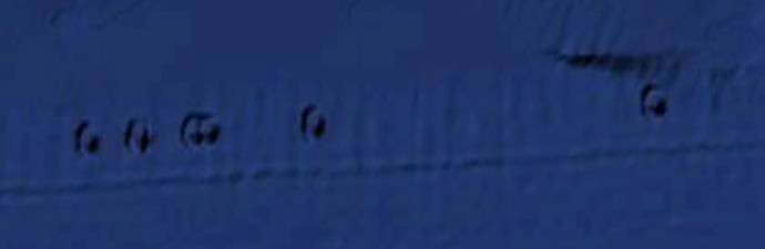
What I saw reminded me quickly of the seams in the hull of very old steam ships, that are riveted together:
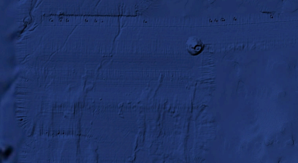
I'm not talking about the lines we are seeing, as those are cause by the sonar data. No, I'm talking about the round objects that are in a line there:
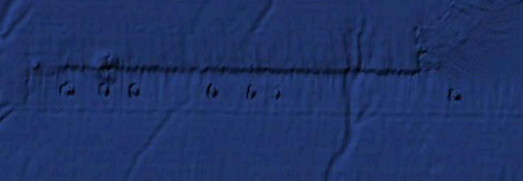
They start at about 107 miles west off the coast of California, and stretch for about 43 miles. The Latitude and Longitude for these is:
N 35 deg 01' 07"
W 122 deg 58' 59"
There are a few more about 22 miles due south of these.
I have no idea what they are (collapsed underwater volcano craters?), and first thought it is just either an artifact from the sonar scan, or an artifact created by Google Earth itself:
The surrounding sea floor is at a depth of about 13,300 to 13,400 feet deep. If you move your cursor over them, the depth does go down some, and then in the center rises 100 to 300 feet for each one.
Most likely something natural that with a higher resolution scan we could see beter.....or Google Earth making interesting artifacts with it's rendering software.
Either way, I thought you folks here at ATS would enjoy speculating about it.
So here is my very own "Strange Structure Under The Ocean" thread.
What I saw reminded me quickly of the seams in the hull of very old steam ships, that are riveted together:
I'm not talking about the lines we are seeing, as those are cause by the sonar data. No, I'm talking about the round objects that are in a line there:
They start at about 107 miles west off the coast of California, and stretch for about 43 miles. The Latitude and Longitude for these is:
N 35 deg 01' 07"
W 122 deg 58' 59"
There are a few more about 22 miles due south of these.
I have no idea what they are (collapsed underwater volcano craters?), and first thought it is just either an artifact from the sonar scan, or an artifact created by Google Earth itself:
The surrounding sea floor is at a depth of about 13,300 to 13,400 feet deep. If you move your cursor over them, the depth does go down some, and then in the center rises 100 to 300 feet for each one.
Most likely something natural that with a higher resolution scan we could see beter.....or Google Earth making interesting artifacts with it's rendering software.
Either way, I thought you folks here at ATS would enjoy speculating about it.
reply to post by eriktheawful
Wow those are intersting. They do look like little ancient volcanos. The way hotspot tend to drift its entirely possibble that a drifter caused these.
As for the rectanglar depression that they are set in... no idea. I find that paticular feature even more interesting. Perhaps you should name this since you found it.
How about gods ruler .
I'm pretty sure the rectangle part is simply higher resolution sonar data. Indeed, if you look at the first picture I posted, you can see how it
snakes back and forth, like a ship that is following a search grid (or a grid for underwater mapping).
Sinkholes? Possibly along a buried fault line or methane pocket? Or ancient inactive black smokers?
Interesting structures none the less.
Interesting structures none the less.
reply to post by eriktheawful
If you're trying to compare the earth to a steam ship, then I wanna know if any lifeboats are present, because I'm jumping before we sink.
If you're trying to compare the earth to a steam ship, then I wanna know if any lifeboats are present, because I'm jumping before we sink.
edit on 16-12-2013 by Zcustosmorum because: (no reason given)
reply to post by eriktheawful
If those aren't the result of digitial artifacts then the lines must be artificial made as thy are dead straight. In the top pic there is one straightline that then changes angle and continues on in another dead straight line.
Ufo base?
If those aren't the result of digitial artifacts then the lines must be artificial made as thy are dead straight. In the top pic there is one straightline that then changes angle and continues on in another dead straight line.
Ufo base?
I'm more interested in the miniature death-star to the 4 o'clock position of your rivets... what's the deal with that thing? Dr. Evil's aquatic
lair? The unblinking eye of Leviathan? The underwater rape colosseum of the dolphin people? The mind fairly boggles.
Erik I am surprised you did not link us to your original data investigation?
Google Ocean is often in need of updating either due to incorrect input or incorrect GPS coordinates by cartographers or the data is not without error (again incorrect coordinates, missing data, etc). All things you are well aware of.
I am however thinking this is just a chain of extinct or active volcanoes near a subduction ridgeline or subduction zone given its location off the California coast. Just because they are in a straightish line means nothing in Geology straight lines are not unheard of especially in volcanic faults.
I am not an expert but I am interested in this just like you however as I believe there are many, many unsolved mysteries of our past under the oceans!
reply to post by abeverage
Nothing to link to I'm afraid, as I'm not using the browser version of Google Earth, but the free standing version that you can download and install for free.
Nothing to link to I'm afraid, as I'm not using the browser version of Google Earth, but the free standing version that you can download and install for free.
reply to post by eriktheawful
Is this the same location?
If it is really interesting in the higher resolution...
Is this the same location?
If it is really interesting in the higher resolution...
It looks like all the circular impressions are the same dimensions as well as the raised circles in the middle. Interesting.
StoutBroux
It looks like all the circular impressions are the same dimensions as well as the raised circles in the middle. Interesting.
Same apparent size too which to me is either data corruption or a repeated pattern in the stitching of the image or....BA BA BUMmmm... Artificiality
Given the size, depth and location I am leaning toward one of the first two.
abeverage
reply to post by eriktheawful
Is this the same location?
If it is really interesting in the higher resolution...
You had the Lat and Long right, but when I clicked on the link it took me to just North of Hawaii (Aloha!), heheheehe.
Here, this link should work:
Link
reply to post by eriktheawful
Adds a whole new twist to the saying 'This spaceship Earth'.
But yeah...undersea volcano string...the pressure makes them flat.
Adds a whole new twist to the saying 'This spaceship Earth'.
But yeah...undersea volcano string...the pressure makes them flat.
eriktheawful
abeverage
reply to post by eriktheawful
Is this the same location?
If it is really interesting in the higher resolution...
You had the Lat and Long right, but when I clicked on the link it took me to just North of Hawaii (Aloha!), heheheehe.
Here, this link should work:
Link
Now how hard was that? lol
reply to post by eriktheawful
Interesting! ...Maybe something left over from WW2? A warning system? Defence? Mines?
F&S
Interesting! ...Maybe something left over from WW2? A warning system? Defence? Mines?
F&S
reply to post by soficrow
Mines as in those horrific implements of war that are prone to explode 50 years later when some unfortunate Vietnamese child is walking to school, or mines as in the underground quarries that unfortunate African children are sent into to extricate diamonds from so some hypocrite rapper can have some dope ice to wear while he raps about the man exploiting his people?
Mines as in those horrific implements of war that are prone to explode 50 years later when some unfortunate Vietnamese child is walking to school, or mines as in the underground quarries that unfortunate African children are sent into to extricate diamonds from so some hypocrite rapper can have some dope ice to wear while he raps about the man exploiting his people?
new topics
-
Any one suspicious of fever promotions events, major investor Goldman Sachs card only.
The Gray Area: 2 hours ago -
God's Righteousness is Greater than Our Wrath
Religion, Faith, And Theology: 6 hours ago -
Electrical tricks for saving money
Education and Media: 9 hours ago -
VP's Secret Service agent brawls with other agents at Andrews
Mainstream News: 10 hours ago -
Sunak spinning the sickness figures
Other Current Events: 11 hours ago -
Nearly 70% Of Americans Want Talks To End War In Ukraine
Political Issues: 11 hours ago
top topics
-
VP's Secret Service agent brawls with other agents at Andrews
Mainstream News: 10 hours ago, 9 flags -
Cats Used as Live Bait to Train Ferocious Pitbulls in Illegal NYC Dogfighting
Social Issues and Civil Unrest: 14 hours ago, 8 flags -
Electrical tricks for saving money
Education and Media: 9 hours ago, 4 flags -
Nearly 70% Of Americans Want Talks To End War In Ukraine
Political Issues: 11 hours ago, 3 flags -
Sunak spinning the sickness figures
Other Current Events: 11 hours ago, 3 flags -
Late Night with the Devil - a really good unusual modern horror film.
Movies: 13 hours ago, 2 flags -
Any one suspicious of fever promotions events, major investor Goldman Sachs card only.
The Gray Area: 2 hours ago, 2 flags -
The Good News According to Jesus - Episode 1
Religion, Faith, And Theology: 16 hours ago, 1 flags -
God's Righteousness is Greater than Our Wrath
Religion, Faith, And Theology: 6 hours ago, 0 flags
active topics
-
Nearly 70% Of Americans Want Talks To End War In Ukraine
Political Issues • 23 • : andy06shake -
Sunak spinning the sickness figures
Other Current Events • 9 • : Ohanka -
God's Righteousness is Greater than Our Wrath
Religion, Faith, And Theology • 16 • : randomuser2034 -
The Acronym Game .. Pt.3
General Chit Chat • 7748 • : bally001 -
HORRIBLE !! Russian Soldier Drinking Own Urine To Survive In Battle
World War Three • 37 • : FlyersFan -
Any one suspicious of fever promotions events, major investor Goldman Sachs card only.
The Gray Area • 3 • : seekshelter -
-@TH3WH17ERABB17- -Q- ---TIME TO SHOW THE WORLD--- -Part- --44--
Dissecting Disinformation • 662 • : F2d5thCavv2 -
SETI chief says US has no evidence for alien technology. 'And we never have'
Aliens and UFOs • 61 • : andy06shake -
The Reality of the Laser
Military Projects • 47 • : F2d5thCavv2 -
Definitive 9.11 Pentagon EVIDENCE.
9/11 Conspiracies • 423 • : Lazy88