It looks like you're using an Ad Blocker.
Please white-list or disable AboveTopSecret.com in your ad-blocking tool.
Thank you.
Some features of ATS will be disabled while you continue to use an ad-blocker.

Chemtrail Islands or just Geo engineering?
page: 6share:
reply to post by fireyaguns
This topic has turned out to be very controversial. I guess secret bases always are, though. Have looked into net offerings for Trindade Island but all there seems to be is a major UFO story from the 1950's. Have looked at other somewhat nearby islands but none of these have yielded possible secrets. Because it's unnamed, though, it could be privately held and that's going to make research tough - just like a privately held company: they don't have to tell us squat.
The UK has been accused of human rights violations over their treatment of the indigenous population on Ascension Island. That's why this has been in the news. Human rights violations will get you kicked out of the EU. (Scots have some experience with these human rights violations at the hands of the UK and that's the connection there.)
Please could someone elaborate on the Israeli connection? Are debunkers saying that the OP video maker is an agent for Israel?
There's going to be (or already is) an ionospheric heater (like HAARP) built to tap the equatorial electrojet. The U.S. is going to want one of their own. In 2009, the drawbacks of the auroral electrojet were already apparent and, at that time, the buzz had it that moves to ships, oil rigs and Puerto Rico were on the table. (U.S.-wise.)
I do believe that someone here in this thread has coined a new term: TROOL. That would be troll + drool = TROOL.
(Didn't get up early enough to read all the deleted posts so not really sure what direction this thread was taking but you all will let me know: are we looking for enemy tankers this morning or are we looking at why Google would need to put fake clouds over an unnamed island?)
reply to post by luxordelphi
So it's a secret base that not only allows, but encourages tourism around it. Not much of a secret.
So it's a secret base that not only allows, but encourages tourism around it. Not much of a secret.
fireyaguns
reply to post by AlphaHawk
why would'nt the two Islands be a perfect base for GEO ENGINEERING EXPERIMNENTS
Because of the altitude of the stratosphere at those latitudes
reply to post by luxordelphi
That is from what she said in a response to a comment on her youtube channel. She only said she was connected to people in Israel and not an agent.
Now whether it is true I can't say, but the video does show that she is a questionable source.
Please could someone elaborate on the Israeli connection? Are debunkers saying that the OP video maker is an agent for Israel?
That is from what she said in a response to a comment on her youtube channel. She only said she was connected to people in Israel and not an agent.
Now whether it is true I can't say, but the video does show that she is a questionable source.
reply to post by luxordelphi
That is something the OP was never totally clear on before this thread went left, although it has straightened out we still don't know exactly why this would be called a secret island, or why they would put in fake clouds.
(Didn't get up early enough to read all the deleted posts so not really sure what direction this thread was taking but you all will let me know: are we looking for enemy tankers this morning or are we looking at why Google would need to put fake clouds over an unnamed island?)
That is something the OP was never totally clear on before this thread went left, although it has straightened out we still don't know exactly why this would be called a secret island, or why they would put in fake clouds.
mrthumpy
fireyaguns
reply to post by AlphaHawk
why would'nt the two Islands be a perfect base for GEO ENGINEERING EXPERIMNENTS
Because of the altitude of the stratosphere at those latitudes
Your answer here is actually very interesting so you'll excuse me for butting in. The tropics have entirely different weather systems than the mid-latitudes and there were a number of studies (which I read some time ago now) on how best to apply solar radiation management (SRM) to these areas. Experiments were done. And then there was silence. I got into it because some contributors to chemtrail threads with locations in the tropics and sub-tropics kept expressing surprise over not seeing the kind of displays in their skies that we all were seeing in ours at mid-latitudes. So the encouragement, look-up, didn't seem to bring any clarity.
So this is just the area where more experimenting would be done because of the peculiar weather conditions that exist here. I had even done a thread on how elites escape chemtrails which I had hoped would take in these areas because they were essentially immune there to chemtrailing. But the thread took a different turn.
There was a paper, a proposal/paper type thing, which I put up in another thread some time ago on how to get around this. It involved ice crystals and changes to crystal structure. That paper, though, in that thread has been replaced by an unrelated paper and I can no longer find it.
reply to post by tsurfer2000h
Tank you for answering my questions. Have a short attention span for videos - I like text and graphics and images. A personal failing I guess in this age.
Could you summarize from the videos that you put up why you feel this person is a questionable source? From what I could understand in the OP video was that there was an unnamed island in some sort of proximity to Ascension Island which Google had painted over with fake clouds in places. The OP seemed to be saying that this unnamed had a connection to the activities on Ascension Island which I previously covered and there seems to be enough there to question goings' on.
imo, the OP is about these fake clouds on this unnamed island and what is being hidden. Bringing Ascension Island into the mix was a way to prove that something could be going on.
A lot of people on ATS and other sites scroll Google Earth looking for anomalies. When they are brought to our attention, like in the OP video, we look to see what there is to it. In this case, imo, there is something to look at. Google, though, presents static images taken, often, some years earlier. This doesn't help with what's there now but also doesn't negate that, back then, something was hidden.
reply to post by luxordelphi
The clouds were covering parts of Ascension Island, not an entire island nearby.
But not any of the military bases or radar facilities had cloud cover..
That's why we're calling it absurd to leap to such conclusions and trying to make the place sound more sinister than it really is.
The clouds were covering parts of Ascension Island, not an entire island nearby.
But not any of the military bases or radar facilities had cloud cover..
That's why we're calling it absurd to leap to such conclusions and trying to make the place sound more sinister than it really is.
edit on 29-11-2013 by AlphaHawk because: (no reason given)
AlphaHawk
reply to post by luxordelphi
The clouds were covering parts of Ascension Island, not an entire island nearby.
But not any of the military bases or radar facilities had cloud cover..
That's why we're calling it absurd to leap to such conclusions and trying to make the place sound more sinister than it really is.
edit on 29-11-2013 by AlphaHawk because: (no reason given)
Look at 2:36 in the OP video. On the right is Ascension and on the lower left, nearer to Brazil, is the unnamed island with the fake clouds in some places. On the zoom-in it shows that it is one of several islands in this area and the island in question is off near the top left of the group at 2:49. At 3:01 you can see what the video author is calling 'obscurements' and which look like clouds to a cursory glance but are actually a flat white.
It is unclear from the video whether or not this cloud formation was an overlay to google earth from this site, which is the first site at the beginning of the video.
CIMSS (Cooperative Institute For Meteorological Satellite Studies)
On their site it does say that google earth needs to be enabled in order to view some of their products. Their products as far as cloud cover, precipitable cover, fog, smoke etc. seem to be pretty sophisticated but I had only begun to navigate the site so can't give detail on how. There is brief mention that artifacts may result with, for instance, fog, but only as far as accurately portraying cut-off edges to the fog.
reply to post by luxordelphi
Here you go pics from this secret no named island...
www.panoramio.com...
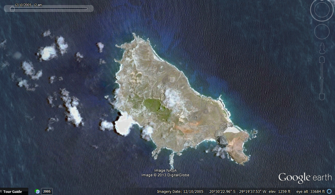
Also here is a pic from 2005 of the same island that shows flat clouds, which btw are flat looking because you are looking at a 2d map from above. Notice the island even looks flat.
The video in the OP is being used by a fearmonger that doesn't seem to actually do much research.
Look at 2:36 in the OP video. On the right is Ascension and on the lower left, nearer to Brazil, is the unnamed island with the fake clouds in some places. On the zoom-in it shows that it is one of several islands in this area and the island in question is off near the top left of the group at 2:49. At 3:01 you can see what the video author is calling 'obscurements' and which look like clouds to a cursory glance but are actually a flat white.
Here you go pics from this secret no named island...
www.panoramio.com...
Also here is a pic from 2005 of the same island that shows flat clouds, which btw are flat looking because you are looking at a 2d map from above. Notice the island even looks flat.
The video in the OP is being used by a fearmonger that doesn't seem to actually do much research.
reply to post by luxordelphi
Well if you do manage to come up with anything be sure and let me know because I've read your post a few times now and it doesn't actually say anything.
My point in response to FYGs question was that the islands wouldn't be suitable for geoengineering experiments because of their location close to the equator. Geoengineering would need to take place up in the stratosphere above the weather and greenhouse gasses to be effective, so therefore a location closer to the poles would be more suitable if anyone were to begin experimenting with geoengineering as the stratosphere is much lower there and so easier to reach.
luxordelphi
A lot of people on ATS and other sites scroll Google Earth looking for anomalies. When they are brought to our attention, like in the OP video, we look to see what there is to it. In this case, imo, there is something to look at. Google, though, presents static images taken, often, some years earlier. This doesn't help with what's there now but also doesn't negate that, back then, something was hidden.
And that is the problem. I gave up on the OP video when the good Reverend claimed that she had found a TTA = Tesla Tech Array adjacent to the runway.
She points it out at 04:24
The woman is clueless. If I get some time later I will highlight her continued stupidity as she gives her 'technical assessment' of what she is finding. Anyone can do what she is doing and is it any wonder that people mock her videos? Jump to 10:00 in the video and hear her informing everyone that what she has found is a 'Space Fence/Fence Array'. It doesn't get much worse than that. See if you can work out for yourself what it is? On a later post I'll show you just how silly this woman and her assessments are.
The 'Tesla Tech Array' she point out at 04:24 is a navigational aid
Zoom into the following map link
VORTAC Ascension
www.ourairports.com...
A VORTAC is a navigational aid for aircraft pilots consisting of a co-located VHF omnidirectional range (VOR) beacon and a tactical air navigation system (TACAN) beacon. Both types of beacons provide pilots azimuth information, but the VOR system is generally used by civil aircraft and the TACAN system by military aircraft.
en.wikipedia.org...
Images of VORTAC at following link
en.wikipedia.org...
I wonder if she is going around Google Earth and place marking every similar navigational beacon as a 'Tesla Tech Array' ?
Moving onto 05:40 she is still rambling on about Tesla Tech Arrays and claiming that this is the same TTA 'we' (US) gave to Israel. If the VORTAC wasn't bad enough! The woman is absolutely clueless. Israel has one and this island has two she claims later on at 06:30 as she hovers the mouse over the Cat Hill site. Seriously making it up as she goes along.
The first 'Golf Ball' radome that she points out is Pyramid Point. It is known as Radar 12.15. The other radar is known as 12.18.
12.15 is also known as Moon Base One.
Image of radar at Pyramid Point
From
www.panoramio.com...
See image of Moon Base One from 1985. Radar back then had no radome.
Image Link
Link to 1985 images
12.15 = AN/FPQ-15
12.18 = AN/TPQ-18
Scroll down to 1-49 Figure 1-28 to see images of the Downrange Radar Systems
www.fas.org...
See what is under the dome at Pyramid Point
Radar at Pyramid Point - Moon Base One
Image of the radar and radar dome at Cat Hill
Image link to radar at Cat Hill site
Image from
spacecovers.com...
Link to image of radars at Cat Hill site
Detachment 2, Ascension Auxilary Air Field
The primary mission of Det 2, 45th Operations Group, is to provide telemetry and radar tracking data to support space launches out of the Eastern Range.
When not supporting its primary mission, the unit has the secondary mission of providing radar tracking data for locating and cataloging space objects in
support of the United States Space Command Space Surveillance Network.
www.patrick.af.mil...
A second function Detachment 2 fulfills for shuttle support is providing orbital tracking via Radar 12.15. Radar 12.15 at Ascension Island is the only equatorial sensor in the Western Hemisphere, and it is capable of tracking over 200 objects per day. For NASA support specifically, Radar 12.15 is tasked with tracking the International Space Station seven days in advance of a shuttle launch to assist in refining the launch time. In addition, Radar 12.15 may be tasked to track the shuttle while in orbit or during docking and undocking from the Space Station.
science.dodlive.mil...

At 06:53 She claims this is so gigantic it spans miles wide and long!
Again yet another example of her making things up. She'd never make an imagery analyst! The Antenna system that is 'miles wide and long' is about 460 metres long.
That antenna array features on the following video at 0:41. Shock horror - it isn't an array to manipulate the weather or any other fantasy, but simply the BBC Atlantic relay station for the BBC World Service.
Antenna field
Image of Antenna as highlighted at 06:53
Antenna image link
www.panoramio.com...
Antennas of BBC Atlantic Relay Station in English Bay
www.panoramio.com...
Some technical details of the antennas used at BBC Ascension
mt-shortwave.blogspot.co.uk...
When I get some more time I will continue with the rest of the good Reverends fantasy video.
edit on 3/12/2013 by tommyjo because: additional info added
I've found some time to continue the run through on the Reverend's fantasy video presentation. The following shows how clueless this woman truly is. Go to 10:03 She point out a 'Fence type array' This is for the 'Space Fence' she claims triumphantly!. She zooms into it at 10:14. She keep repeating it 'Fence type array'.
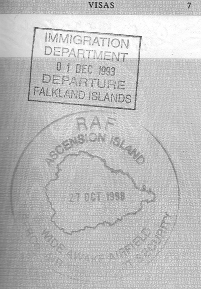
Absolutely clueless and she is simply fear mongering and creating a fantasy. What she claims is a 'Fence Array' is actually water pipelines. I should know as I have driven along that road countless times. See the image in this post to some of my passport stamps. Her mistake was not following the 'Fence Array' as it continued eastwards to English Bay and south westerly to Two Boats. The following image shows part of the above ground pipelines mounted on their supports. The pipeline runs along parts of Pyramid Point Road and English Bay Road.
The following map link is centered on the pipeline right angle near the road junction.
Map Link
See also images and info from tourists.
Tourist image link
In the picture above, if you look carefully you can see three lines of pipe. The dark cast iron one carried water down under gravity from the mountain, and put in place in the mid 19th century by the marines and lasted about 100 years . The pale turquoise one, i.e. the lower of the two coloured ones was built in the 60's to carry water up to two boats from the desalinisation unit at the BBC power station at English bay, and the blue top one is a replacement for the turquoise one which is now giving problems. So that makes the score, Marines 1 BBC 0 , when it comes to constructing pipelines.
From
www.les-smith.com...
The above ground pipelines are a feature of the island. Note following pipeline at Cat Hill.
Cat Hill image link showing pipelines
Map centered on right angle of pipeline at Cat Hill, Ascension Island.
Map Link
No doubt if she was directed to the other above ground pipelines she would still be claiming 'Fence array/Space Fence'. She is just an example of how a clueless individual can generate a fantasy and promote fear mongering.
Just to prove that I have been to Ascension Island.
More to follow on the next post in the area of the pipe line.
See from 07:46 (Area of pipeline) on the video and her continued fantasy presentation. 08:59 "Here is another kind of array" 09:15, 09:21 "Another triangular antenna array"
Those triangular antennas are Rotatable Log Periodic. The circular areas are omni-directional antennas The antenna farm is part of the US High Frequency Global Communication System.
HF-GCS Link
HF-GCS Presentation
Some images of the Ascension antenna farm. Note the omni-directional antenna and especially the angled supports of the Spira Cone in the background?
Image of Antenna at the location shown at 07:46
From
Link
Note the same Spira-Cone antenna type at another HF-GCS site at Lajes, Azores.
Image of Spira Cone at Lajes Azores
From
Link
The triangular type antenna are rotatable directional Log Periodic Antenna.
Link to Log Periodic info
Link
Spira-Cone Omni-Directional Antenna
Link to Spira Cone info
Link
Spira-Cone Antenna in Australia - Picture of Antenna and corresponding overhead map image.
Link
Good reference for Antenna Types
Here is someone else on You Tube claiming that there is 'HAARP in Omaha Nebraska?' All they are filming is another station of the High Frequency Global Communication System. Note the Rotatable Log Periodic Antenna and Spira Cones featured in the video - the same as on Ascension Island.
Map Link of the HF-GCS site in Nebraska
Image link showing a Log Periodic Antenna at Nebraska
One of eight directional rotatable log periodic antennas maintained by the 55th Strategic Communications Squadron near Elkhorn, Neb., stands tall behind a cornfield.
Spread out over 386 acres just outside of Elkhorn, with an additional 156 acres in Scribner, Neb., the communications site features 32 antennas. This includes 15 high frequency, eight directional rotatable log periodic and nine omni directional antennas.
From
Link
new topics
-
Should Biden Replace Harris With AOC On the 2024 Democrat Ticket?
2024 Elections: 19 minutes ago -
Intro once again
Introductions: 1 hours ago -
University student disciplined after saying veganism is wrong and gender fluidity is stupid
Education and Media: 2 hours ago -
Geddy Lee in Conversation with Alex Lifeson - My Effin’ Life
People: 3 hours ago -
God lived as a Devil Dog.
Short Stories: 4 hours ago -
Police clash with St George’s Day protesters at central London rally
Social Issues and Civil Unrest: 5 hours ago -
TLDR post about ATS and why I love it and hope we all stay together somewhere
General Chit Chat: 6 hours ago -
Hate makes for strange bedfellows
US Political Madness: 8 hours ago -
Who guards the guards
US Political Madness: 11 hours ago
top topics
-
Hate makes for strange bedfellows
US Political Madness: 8 hours ago, 16 flags -
Who guards the guards
US Political Madness: 11 hours ago, 13 flags -
Police clash with St George’s Day protesters at central London rally
Social Issues and Civil Unrest: 5 hours ago, 8 flags -
TLDR post about ATS and why I love it and hope we all stay together somewhere
General Chit Chat: 6 hours ago, 5 flags -
University student disciplined after saying veganism is wrong and gender fluidity is stupid
Education and Media: 2 hours ago, 5 flags -
Has Tesla manipulated data logs to cover up auto pilot crash?
Automotive Discussion: 13 hours ago, 2 flags -
Intro once again
Introductions: 1 hours ago, 2 flags -
Geddy Lee in Conversation with Alex Lifeson - My Effin’ Life
People: 3 hours ago, 2 flags -
God lived as a Devil Dog.
Short Stories: 4 hours ago, 2 flags -
Should Biden Replace Harris With AOC On the 2024 Democrat Ticket?
2024 Elections: 19 minutes ago, 1 flags
active topics
-
"We're All Hamas" Heard at Columbia University Protests
Social Issues and Civil Unrest • 256 • : YourFaceAgain -
-@TH3WH17ERABB17- -Q- ---TIME TO SHOW THE WORLD--- -Part- --44--
Dissecting Disinformation • 630 • : RookQueen2 -
University student disciplined after saying veganism is wrong and gender fluidity is stupid
Education and Media • 15 • : TzarChasm -
Mood Music Part VI
Music • 3092 • : TheWoker -
Hate makes for strange bedfellows
US Political Madness • 35 • : Degradation33 -
Should Biden Replace Harris With AOC On the 2024 Democrat Ticket?
2024 Elections • 2 • : FlyersFan -
Europe declares war on Russia?
World War Three • 67 • : 777Vader -
1980s Arcade
General Chit Chat • 22 • : VirginOfGrand -
Terrifying Encounters With The Black Eyed Kids
Paranormal Studies • 64 • : FlyersFan -
Geddy Lee in Conversation with Alex Lifeson - My Effin’ Life
People • 3 • : ManSizedSquirrel