It looks like you're using an Ad Blocker.
Please white-list or disable AboveTopSecret.com in your ad-blocking tool.
Thank you.
Some features of ATS will be disabled while you continue to use an ad-blocker.

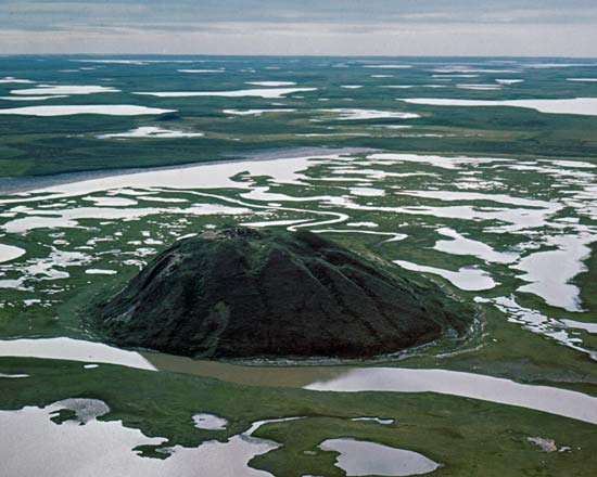
*very* mysterious mound in Russia. a cone where no cone should ever be!
page: 10share:
reply to post by Mstreman
Got any pics of these other pingo's?. Would really help illustrate your point
2nd.
Got any pics of these other pingo's?. Would really help illustrate your point
2nd.
Mstreman
I have recently completed a review of the geological literature and the consensus is that this is a periglacial structure very similar to--if not the same as-- a "pingo". Alekseyev (2012) Patom Cone aka Patomsky Krater appears to be a unique land form in Irkutsk itself and has enough variation to be unique in all the world. Pingos form in permafrost areas but not under an ice sheet--hence "peri-glacial". There are hundreds if not thousands of them across the Arctic. Some larger and some smaller. The research supports an ice wedging/ ice jacking of ice fractured bedrock and excludes a volcano or meteorite origin.
This region( Trans Bakial Mountains) was covered by a southern icecap from the Gobi ice sheet which was in existence up to 6000ybp(?). The permafrost has been determined to be up to an astonishing 200m in the region and may have existed until very recently. A pingo forms over many decades as ground water fills natural rock joints and with each freeze cycle shatters the bedrock. Through many cycles the small channels enlarge into a major large one. After this merging the growth is rapid yet cyclical with freeze-thaw episodes. The ice platform jacks the shattered clast of rocks to the surface and those that spill over start building the cone's side walls. The inner cone may represent a final swan's song in development when the area warmed to the point that the permafrost was depleted. Many pingos subside and form lakes in the basins within the peak. Those lakes over fill and in a mature pingo finally cut multiple channels giving it a griddle appearance with many multiple mini peaks. Pingos are hydraulic laccoliths. They require a groundwater and permafrost interaction over time in order to form. Suggested reading the Wikipedia article on Pingo.
Antipin (2011) First thought this was a young volcano. When that was disproved, he theorized that the original cone was formed when deep magma generated CO and H2 gas which worked its way to the surface and exploded when mixed with air. The physics in general and evidence within the cone itself don't support such a working theory. There is some trace of methane and carbon monoxide at the cone. So while a gas explosion may be remote, the possibility that deep gas can be released is not so remote. However it speaks little against the probability that this is a structure formed by ice wedging.
There is no evidence what-so-ever of a buried UFO. A Russian Biologist put forth that theory based on a misunderstanding of a uranium concentration in trees beginning 50-60 years ago running for 20 years( deeply in the cold war years). The crater is not far from a one of the world's largest mining districts: Murun and coincides with suspected large scale uranium mining in the region. The biologist put forth the concept that a nuclear reactor engine exploded after a crash and made a bulge. He himself admitted that he did not understand reactor related isotopes. The radioactivity at the cone is actually below the regional background which is understandable given the large "average" background level owing to close by uranium deposits.
Some other expeditions mapped the gravity and 2/3D image of the cone and found no magma channel and a profile for a pingo and not that of a meteorite impact. Ermolin (2011), (Demezhko et al., 2011)
This is probably the most educated and researched response on this thread yet. I'm surprised there is that much information is out there in the academic world on this subject, thanks!
reply to post by binaryangel
I did not retain all the links to photos. A net search for images will show many( i.e Google Images). There are even national parks in Canada dedicated to pingos. I also suggest reading the article at wikipedia for "pingo" as it has excellent illustrations on pingo development. I want to reiterate that Patom Cone may be a unique feature but there are at least a few pingos which have the inner knoll/bulge. There are some pingos situated at the base of slopes and a few small ones on slopes but none I recall that are as spectacular as Patom nor seemingly isolated like this. Ergo I adhere to a pingo-like or pingo-form label descriptor. There are four known variations of pingo formation and perhaps therei is a 5th. There is yet much to be learned about this feature.
Incidentally, Some expeditions dated fallen trees under the edge of the cone to about 500 years old and assume the crater is that age. It is probably much older. Talus slippage well after the cone's formation (e.g creep) may have knocked the tree over but that process also is driven by frost wedging and may have taken hundreds to thousands of years to reach the area where the 500 year old larch tree was found. . I think the fact that a biologist dated the tree and just assumed that the tree died during cone formation may have given an (invalid) assumption that subsequent geologist just took his word for it. As is often done in science, if you lack a team who brain storms the whole gamut of possibilities ,bias and fallacy can work its way into the honest research. Alekseyev is a tundra and pingo expert and visited the cone so I tend to put more validity into his work. Antipin is a petrologist /ore expert and did not visit the cone but just analyzed the samples. I don't think he intentionally tried to mislead but, I find issues with many of his assumptions and interpretations. The pingo formation process makes the most sense given everything else has been almost completely ruled out. I think it is going to take a coring of the cone cross section to see if anything else is there. There is a means to date calcite and quartz burial dates by a complicated total dark extraction to a lab where residual light photons can be measured. Perhaps that is the next test but it is difficult to do with rock clasts this size. It is usually done with sands to determine when a sand dune or sand outwash plane from a glacier was lain down.
reply to post by Mstreman
I did not retain all the links to photos.
But you retained some? Please, if you have access to any it would be nice if you would post them. Its quite difficult to take you seriously as a researcher if you dont retain your research.
Asking me to "google" it is lazy on your part, and being that its your claim the onus of proof is on you; Or as we say here on the interwebs: PICS OR DIDNT HAPPEN
reply to post by binaryangel
Pingo
I did not retain ALL the links to photos(nor maps and pdf files)...which I downloaded-- I should have said. Ergo, as virtually everything was found online, I don't have a "complete list of links" nor a desire to organize and post what I do have. I've already spent 2 unpaid weeks on this project and I am not inspired to spend 2 more.
Looking to My Cost/Benefit I will never change the minds of UFO affectionados and those conspiracy mongers that think this is a HAARP bored hole. I shared what I had found. I study craters volcanic and astroblemes/impact craters and this was an outgrowth of that work. I spent more unpaid time in this review than I intended. True I did not provide a bibliography but the names and years of the researcher's works were included--i was not submitting a paper for publication. I stand by what I wrote. I have no hidden counter-conspiracy agenda and anyone is welcome to review the research papers I cited and reach their own conclusions.
There were 10 pages here alone in comments and I thought at least two or three of the posters were genuinely interested in the opinions and conclusions of the geological community. There were several unfounded unworkable theories around the net but I understand their flaws and it wasn't my purpose to refute them all in detail. Please appreciate that I can't impart 40 years of geological experience into a single blog post.
edit
on 22-2-2014 by Mstreman because: (no reason given)
edit on 22-2-2014 by Mstreman because: Expansion of why no more links were
included
edit on 22-2-2014 by Mstreman because: (no reason given)
edit on 22-2-2014 by Mstreman because: Irrelevant test link
removed
reply to post by Mstreman
I dont think anyone here suggested it was the result of HAARP--but maybe I missed that.
^^ Is that what you mean by "pingo"?, thats what a google image search turned up. I'll leave it up to the other thread contributors to make up their own mind.
I dont think anyone here suggested it was the result of HAARP--but maybe I missed that.
^^ Is that what you mean by "pingo"?, thats what a google image search turned up. I'll leave it up to the other thread contributors to make up their own mind.
I found this thread while researching Patom and noted many well intentioned but factually incorrect assumptions. I informally reported back my summary
of the literature.
There are hundreds of pingo photos including ones with the nested inner disk. So you picked the first one you found that is representative of arctic circle pingos in general but not one more similar to Patom cone. I am confident you did not read any of the geological literature nor much what I wrote. So four questions for you to ask yourself in your own head.
1) Do you understand there are at least 4 subsets of pingo origins depending on closed or open systems, external and internal conditions and climate specificity? You would have if you had read the recommended articles, Pingos are a class of hydro-laccolyths which come in many " flavors".
2) What do you say it is? .
3) What is your hidden agenda?
4) Why does it take 4 posts to get you to goggle the info yourself...see #3 above.
I am not here to debate anyone's beliefs nor to give them a crash course in cyro-geology, crypto-geology--nor discuss the subtle distinction between the meannigs of "pingo and pingo-like". Sorry, structural geology is not made of of soundbites nor absorbed by spoon feeding. Your are free to read the entire body of geological research and draw your own conclusions of what research geologists have said in their papers. I am not here to convince anyone this is anything at all. What part of "review of the geological literature" do you think was my hidden agenda to "hide" the truth?
new topics
-
That which the "news" never talks about; Truth about election fraud
Mainstream News: 1 minutes ago -
Biden doesnt want the votes of "Death to America" chanters
US Political Madness: 8 minutes ago -
Horizon Post office scandal
Regional Politics: 49 minutes ago -
Joe Biden and Donald Trump are both traitors
US Political Madness: 2 hours ago -
I'm new here. Avid conspiracy fan.
Introductions: 3 hours ago -
Denmark's Notre-Dame moment - 17th Century Borsen goes up in Flames
Mainstream News: 4 hours ago
top topics
-
Suspected Iranian agent working for Pentagon while U.S. coordinated defense of Israel
US Political Madness: 12 hours ago, 16 flags -
The Baloney aka BS Detection Kit
Social Issues and Civil Unrest: 12 hours ago, 7 flags -
Denmark's Notre-Dame moment - 17th Century Borsen goes up in Flames
Mainstream News: 4 hours ago, 4 flags -
How does my computer know
Education and Media: 15 hours ago, 3 flags -
I'm new here. Avid conspiracy fan.
Introductions: 3 hours ago, 3 flags -
Joe Biden and Donald Trump are both traitors
US Political Madness: 2 hours ago, 2 flags -
Horizon Post office scandal
Regional Politics: 49 minutes ago, 1 flags -
That which the "news" never talks about; Truth about election fraud
Mainstream News: 1 minutes ago, 1 flags -
Biden doesnt want the votes of "Death to America" chanters
US Political Madness: 8 minutes ago, 0 flags
active topics
-
That which the "news" never talks about; Truth about election fraud
Mainstream News • 0 • : ADVISOR -
Joe Biden and Donald Trump are both traitors
US Political Madness • 28 • : YourFaceAgain -
Candidate TRUMP Now Has Crazy Judge JUAN MERCHAN After Him - The Stormy Daniels Hush-Money Case.
Political Conspiracies • 239 • : matafuchs -
How does my computer know
Education and Media • 18 • : MrGashler -
It has begun... Iran begins attack on Israel, launches tons of drones towards the country
World War Three • 746 • : CriticalStinker -
Truth Social goes public, be careful not to lose your money
Mainstream News • 114 • : matafuchs -
Biden doesnt want the votes of "Death to America" chanters
US Political Madness • 0 • : ColeYounger2 -
NYAG Letitia James Prepares to Begin Seizing TRUMP Assets Even Though There Was No Crime.
Above Politics • 285 • : matafuchs -
Anti-Israel Protesters in CHICAGO Chant 'Death to Israel and 'Death to America'
Social Issues and Civil Unrest • 43 • : ARM19688 -
I'm new here. Avid conspiracy fan.
Introductions • 10 • : lilzazz