It looks like you're using an Ad Blocker.
Please white-list or disable AboveTopSecret.com in your ad-blocking tool.
Thank you.
Some features of ATS will be disabled while you continue to use an ad-blocker.

Super Typhoon Haiyan gaining strength, will strike Philippines with maximum strength of category 5!
page: 1share:
Look's very bad, hope people there will take wearings very seriously and stay safe ..
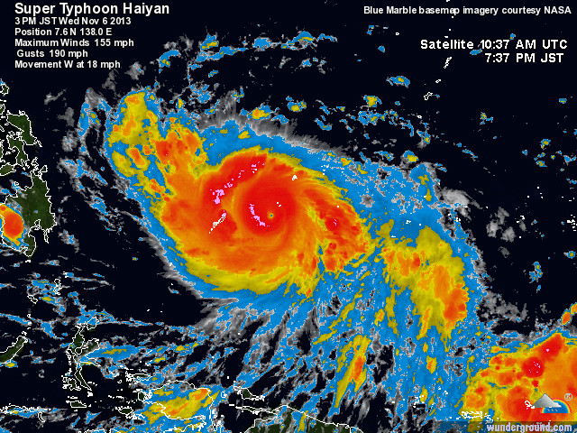
Typhoon Haiyan is intensifying as it continues to move across the northern Pacific, packing winds of up to 240 kilometers per hour.
The expected track of Haiyan will take it directly over the areas hardest hit by a powerful 7.1 magnitude earthquake that killed more than 200 people in the middle of October.
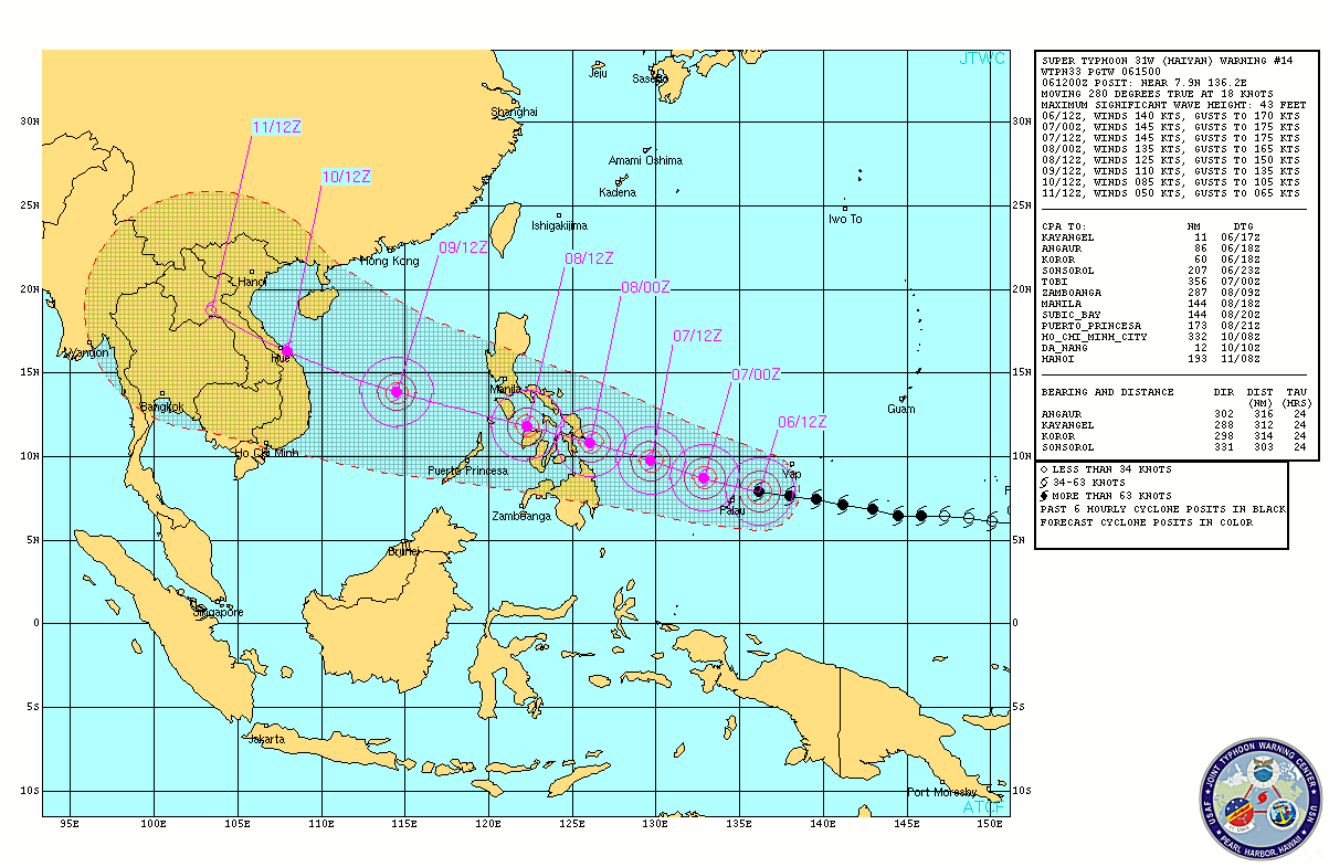
Strengthening Super Typhoon Haiyan is posing a serious threat to lives and property across the Philippines.
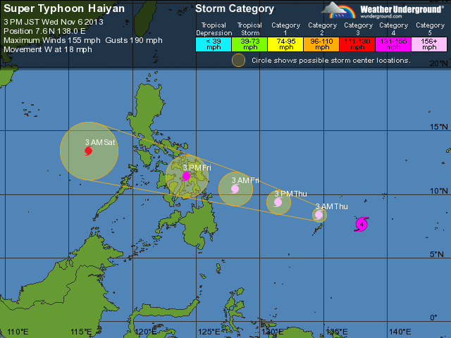
Nov 04 18 GMT 6.5 147.3 65 -999 Tropical Storm
Nov 05 00 GMT 6.4 145.9 75 -999 Typhoon
Nov 05 06 GMT 6.4 144.5 75 -999 Typhoon
Nov 05 12 GMT 6.8 143.0 105 -999 Typhoon
Nov 05 18 GMT 7.1 141.2 120 -999 Typhoon
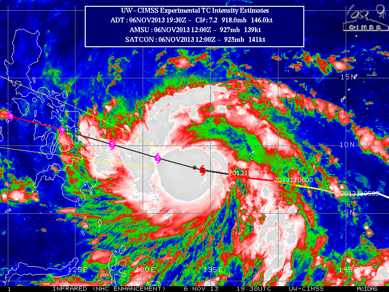
Nov 06 00 GMT 7.4 139.6 150 -999 Super Typhoon
Nov 06 06 GMT 7.6 138.0 155 -999 Super Typhoon
www.abc.net.au...
www.accuweather.com...
www.wunderground.com...
Typhoon Haiyan is intensifying as it continues to move across the northern Pacific, packing winds of up to 240 kilometers per hour.
The expected track of Haiyan will take it directly over the areas hardest hit by a powerful 7.1 magnitude earthquake that killed more than 200 people in the middle of October.
Strengthening Super Typhoon Haiyan is posing a serious threat to lives and property across the Philippines.
Nov 04 18 GMT 6.5 147.3 65 -999 Tropical Storm
Nov 05 00 GMT 6.4 145.9 75 -999 Typhoon
Nov 05 06 GMT 6.4 144.5 75 -999 Typhoon
Nov 05 12 GMT 6.8 143.0 105 -999 Typhoon
Nov 05 18 GMT 7.1 141.2 120 -999 Typhoon
Nov 06 00 GMT 7.4 139.6 150 -999 Super Typhoon
Nov 06 06 GMT 7.6 138.0 155 -999 Super Typhoon
"It's going pretty quickly and it's going to go to Palau and south of Yap but there's a little island there with a few people called Nrulu and they're probably going to get the eye of the typhoon over them," he said.
The Palau National Emergency Management Office (NEMO) is advising the public to tune into local broadcasters for updates and to stock up on emergency supplies.
Palau's government offices and schools will remain shut until Friday.
Audio: Powerful typhoon bearing down on Micronesia (ABC News)
Mr Ziobro says many of the islands in the path of the typhoon are low-lying areas.
"Some of these little islands are not very high... levels above the ocean so some of the wave action would be higher than atolls," he said.
"They might be only about 10 feet high and we're expecting seas of 13-16 feet and probably even higher than that and it could over wash the island."
'Most dangerous storm'
Haiyan is expected to reach central Philippines as a super typhoon by Friday noon local time, moving at 233-249 kilometres per hour, according to Michael Ziobrol.
"If people are in the Philippines, they should start preparing too, especially the central Philippines," he said.
Dr Jeff Masters, a contributor to the weather blog Wunderground, says Haiyan will likely be the most dangerous tropical cyclone to affect the Philippines this year.
Haiyan became a super typhoon early Tuesday night with maximum sustained winds of 240 kph (150 mph).
www.abc.net.au...
www.accuweather.com...
www.wunderground.com...
edit on 6-11-2013 by MariaLida because: (no reason given)
Super Typhoon Haiyan a Serious Threat to the Philippines
Strengthening Super Typhoon Haiyan is posing a serious threat to lives and property across the Philippines.
Haiyan became a super typhoon early Tuesday night with maximum sustained winds of 240 kph (150 mph).
www.thehindu.com...
www.accuweather.com...
"Traveling at a faster speed of 30 kph (from the previous 20 kph), the typhoon, according to the Philippine Atmospheric Geophysical and Astronomical Services Administration (Pagasa), is expected to arrive as early as Wednesday midnight. It is forecast to make landfall in eastern Visayas on Friday. It would affect the Visayas and parts of Luzon and Mindanao."
newsinfo.inquirer.net...
Strengthening Super Typhoon Haiyan is posing a serious threat to lives and property across the Philippines.
Haiyan became a super typhoon early Tuesday night with maximum sustained winds of 240 kph (150 mph).
Philippine officials on Wednesday raised the alert for a powerful typhoon threatening the country’s eastern coast and urged residents to leave high-risk areas before the storm hits.
Typhoon Haiyan was barrelling towards eastern and central provinces with maximum winds of 240 kilometres per hour (kph) and gusts of up to 295 kph. It was expected to intensify as it neared land, weather forecasters warned.
Haiyan, which will be called locally as Yolanda, was expected to make landfall over the eastern provinces of Samar and Leyte on Friday.
Interior Secretary Mar Roxas urged residents to be prepared for evacuation, especially those living along coastlines and other high-risk areas. “All our preparation will be for nothing if we will still wait for the typhoon to arrive before we act,” he told a meeting of disaster relief officials and workers.
www.thehindu.com...
www.accuweather.com...
"Traveling at a faster speed of 30 kph (from the previous 20 kph), the typhoon, according to the Philippine Atmospheric Geophysical and Astronomical Services Administration (Pagasa), is expected to arrive as early as Wednesday midnight. It is forecast to make landfall in eastern Visayas on Friday. It would affect the Visayas and parts of Luzon and Mindanao."
newsinfo.inquirer.net...
edit on 6-11-2013 by MariaLida because: (no reason given)
Seems everywhere is getting some major winds and storms.
This one looks like a real beast too, i wonder if it will vanish like the two storms near japan recently?
This one looks like a real beast too, i wonder if it will vanish like the two storms near japan recently?
"Typhoon Bopha packed winds of up to 175 mph when it struck the island nation, bringing torrential rains that flattened entire villages, leaving
thousands homeless, as well as washing out roads and bridges needed by rescue personnel trying to reach stricken regions"
Formed November 25, 2012
Dissipated December 9, 2012
Highest winds 10-minute sustained:
185 km/h (115 mph)
1-minute sustained:
280 km/h (175 mph)
Lowest pressure 930 mbar (hPa); 27.46 inHg
Fatalities 1,146 total, 834 missing
Damage $1.04 billion (2012 USD)
Areas affected Federated States of Micronesia, Palau, Philippines
www.wunderground.com...
en.wikipedia.org...
OMG this is a bad one. Sending positive thoughts to all those in this thing's path. Stay safe over there.
Its true that there has been winds like carzy lately, even in my area (Ottawa, canada) we had gusts of up to 120km/h all day friday, I almost lost my fence that day.
All that with a 5 hour blackout. But this was nothing in comparisson to what those poor people are facing.
Its true that there has been winds like carzy lately, even in my area (Ottawa, canada) we had gusts of up to 120km/h all day friday, I almost lost my fence that day.
All that with a 5 hour blackout. But this was nothing in comparisson to what those poor people are facing.
Typhoon Haiyan ..
Category 5 ..
Last Updated: 6. studeni 2013, 13:00:00 (Central European Standard Time)
Wind: 260 KPH
Location: 7.9N 223.8E
Movement: W at 20 mph
www.wunderground.com...
www.ssd.noaa.gov...
www.ssd.noaa.gov...
www.ssd.noaa.gov...
www.ssd.noaa.gov...
Category 5 ..
Last Updated: 6. studeni 2013, 13:00:00 (Central European Standard Time)
Wind: 260 KPH
Location: 7.9N 223.8E
Movement: W at 20 mph
www.wunderground.com...
www.ssd.noaa.gov...
www.ssd.noaa.gov...
www.ssd.noaa.gov...
www.ssd.noaa.gov...
edit on 6-11-2013 by MariaLida because: (no reason given)
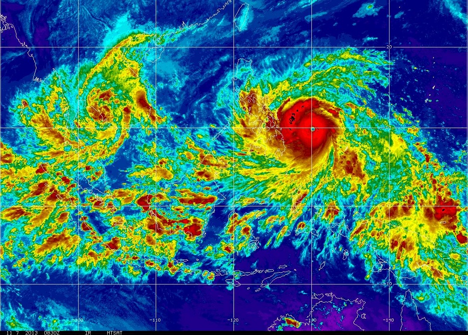
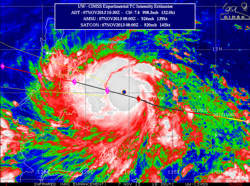
Not looking good ..
Latest image ..
Now It's over Palau (
files.abovetopsecret.com...
Latest image ..
Now It's over Palau (
files.abovetopsecret.com...
edit on 6-11-2013 by MariaLida because: (no reason given)
Serious wtf with this storm. Right now it is hammering Palau, the likes of which I have never seen in almost a decade of being here.
The size of the strong areas of the storm is larger than the size of Mindanao island, or around 1/5th of Texas... With sustained winds of ~160 miles per hour to ~200 mph
Luckily it is a fast moving storm that will cause damage and move on, and not linger around moving by slowly.
The size of the strong areas of the storm is larger than the size of Mindanao island, or around 1/5th of Texas... With sustained winds of ~160 miles per hour to ~200 mph
Luckily it is a fast moving storm that will cause damage and move on, and not linger around moving by slowly.
Teye22
OMG this is a bad one. Sending positive thoughts to all those in this thing's path. Stay safe over there.
Its true that there has been winds like carzy lately, even in my area (Ottawa, canada) we had gusts of up to 120km/h all day friday, I almost lost my fence that day.
All that with a 5 hour blackout. But this was nothing in comparisson to what those poor people are facing.
Yes, this is going to be a very very bad one for those in its path. This comes following a recent earthquake disaster in Bohol.
This typhoon will be the first very strong one in a long time (projected) to hit the middle of the Visayas (middle islands in Phillines) region. There will probably be things shredded, broken, and damaged, but hopefully minimal flooding. If the storm is slow, there is flooding. If the storm is fast, there is damage but not much water... from my experience.
Typhoon Bopha which hit Mindanao last year was also a Category 5 typhoon packing winds at 175 mph. Looks like Haiyan is going to break the record.
Last year, areas that got hit by Bopha in Mindanao looked like it got nuked.
Thanks for thinking of us....
i have sent my good byes and i love yous
Bushman Canuck saying good night from Cordova, Mactan, Cebu
i have sent my good byes and i love yous
Bushman Canuck saying good night from Cordova, Mactan, Cebu
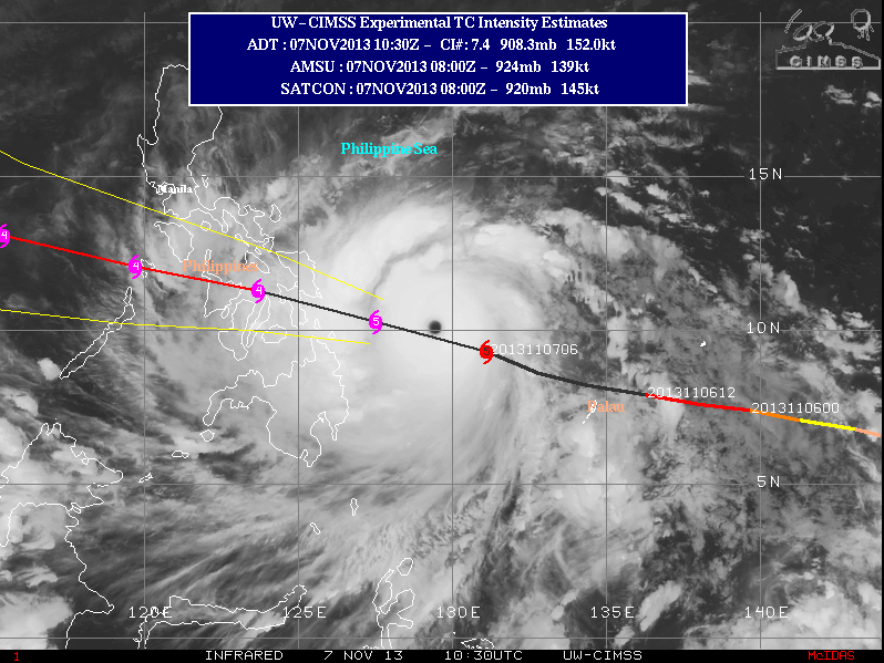
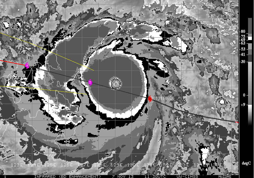
Latest image ..
: (
files.abovetopsecret.com...
www.ssd.noaa.gov...
: (
files.abovetopsecret.com...
www.ssd.noaa.gov...
edit on 6-11-2013 by MariaLida because: (no reason given)
Last Updated: 6. studeni 2013, 19:00:00 (Central European Standard Time)
Wind: 280 KPH
Location: 8.2N 225.6E
Movement: W at 20 mph
www.wunderground.com...
This typhoon is similar in track and strength of Super Typhoon MIKE (RUPING) which passed across the Visayas in November of 1991 and devastated much of Metro Cebu. Residents living along the eastern seaboards of the Philippines from Northern Quezon...Bicol Region...down to Northeastern Mindanao should closely monitor the approach of this potentially destructive typhoon. Plans for emergency situations and/or disaster management planning must be implemented beginning today.
Super Typhoon MIKE (RUPING)
Formed November 5, 1990
Dissipated November 18, 1990
Highest winds 10-minute sustained:
185 km/h (115 mph)
1-minute sustained:
280 km/h (175 mph)
Lowest pressure 915 mbar (hPa); 27.02 inHg
Fatalities 748 direct
Damage $220 million (1990 USD)
en.wikipedia.org...
en.wikipedia.org...:Mike_1990_track.png
edit on 6-11-2013 by MariaLida because: (no reason given)
For everyone about to get hit by this beast, please stay safe, away from any possibility of being harmed by flying or falling objects (coconuts,
coconut trees, billboards, trash, etc.)
This storm will have gusts upwards of 300+ kph winds (200+ mph), and looks like it will barrel through the Visayas quickly.
From NOAA
This storm will have gusts upwards of 300+ kph winds (200+ mph), and looks like it will barrel through the Visayas quickly.
From NOAA
reply to post by MariaLida
I always find it strange that since moving here to the Philippines, I'm still the last one to know when we are going to get a typhoon. Hell, I didn't even know there was an earth quake until 3 days after it happened.
There was some pretty good winds here about a month ago, stronger than I remember in a long time. Luckily I live on the weakening side of this storm, in the Quezon City area. Looking at the forecast though looks like I'm going to get some of it. the biggest problem where I live is flooding.
Poor drainage leads to flash flooding the likes of which I have never seen before. Have some friends in Daet, that may get some of the bad wind that may go along with this. Hope it blows over and isn't nearly as bad as suspected.
Anyway, Thanks OP for letting me know. Had I not been perusing ATS before work I would never have seen this.. S&F
Stay safe everyone. Buckle down, generators, water, the usual...I hope people had time to prepare...good luck to those there, & if you can read this,
please post to let us know your o.k....TY O.P....S&F👍
Last Updated: 7. studeni 2013, 7:00:00 (Central European Standard Time)
Wind: 280 KPH
Location: 9.3N 228.9E
Movement: WNW at 20 mph
www.wunderground.com...
files.abovetopsecret.com...
files.abovetopsecret.com...
files.abovetopsecret.com...
Wind: 280 KPH
Location: 9.3N 228.9E
Movement: WNW at 20 mph
www.wunderground.com...
files.abovetopsecret.com...
files.abovetopsecret.com...
files.abovetopsecret.com...
edit on 7-11-2013 by MariaLida because: (no reason given)
Super typhoon Haiyan aims at Philippines; 'significant loss of life' predicted
1 hour ago
worldnews.nbcnews.com...
1 hour ago
By Alexander Smith, NBC News contributor
Thousands of villagers fled as the most powerful storm on the planet this year approached the Philippines on Thursday.
Super typhoon Haiyan had wind speeds of up to 170 mph and was rated as a category-five storm early Thursday, according to Weather Channel lead meteorologist Michael Palmer.
He warned that the storm was likely to cause widespread devastation and "a significant loss of life."
“It’s a very poor country and there is not really any place for these people to go because they are on an island," Palmer added. “There was a similar typhoon that struck in 1990 which killed 700 people so you are going to see that here, maybe even worse.”
worldnews.nbcnews.com...
This storm is a beast... What's scary is that we are seeing some of the most violent storms today. Just a cycle or are we moving into a era where this
is more the norm?
Definitely saying a prayer for all the people of this area. Stay safe
CNN
Definitely saying a prayer for all the people of this area. Stay safe
(CNN) -- Thousands of people in vulnerable areas of the Philippines are being relocated as the strongest storm on the planet so far this year spins toward the country.
With sustained winds of 305 kph (190 mph) and gusts as strong as 370 kph (230 mph), Super Typhoon Haiyan was churning across the Western Pacific toward the central Philippines as one of the most intense tropical cyclones ever recorded.
Its wind strength makes it equivalent to an exceptionally strong Category 5 hurricane.
The storm, known as Yolanda in the Philippines, is expected to still be a super typhoon, with winds in excess of 240 kph (149 mph), when it makes landfall Friday morning in the region of Eastern Visayas.
The storm is so large in diameter that clouds from it are affecting two-thirds of the country.
CNN
edit on 7-11-2013 by jhn7537 because:
(no reason given)
On the mobile at inlaws south mactan...time to finaly rest, worked like a mad man with two helpers today. Working the last two days and got everything
done, windows boarded, fully stocked ect.
Trying to hydrate
Have a post storm security plan too. If infrastructure is wiped out power could be out for months li,e in 1990. It will be a very ugly time. Economy will be severly disrupted and filter all the way down to the tricicad drivers.
There is a power plant in Leyte that feeds Cebu...talking to local electrical engineer tonight, he says if we loose Leyte power supply there will be big problems for Cebu.
I just found this....to back it upwww.philstar....repares-typhoon...
people will be very hungry.....and wanting what you have, thieves go to work quikly. Don't worry about it now....just somthing to think about post storm.
Cuddle tight tonight folks...see you on the other side I'm so tired...I can't look at another spaghetti map. Worked so hard today prepping. calm before the storm was so dead...I should have gone to sleep then. The rain has started, no wind in my location just yet. Good night folks, going to charge up for game time....6-10 hours from now I think.
To top it off we still feel the odd aftershock here.
new topics
-
12 jurors selected in Trump criminal trial
US Political Madness: 2 hours ago -
Iran launches Retalliation Strike 4.18.24
World War Three: 2 hours ago -
Israeli Missile Strikes in Iran, Explosions in Syria + Iraq
World War Three: 2 hours ago -
George Knapp AMA on DI
Area 51 and other Facilities: 8 hours ago -
Not Aliens but a Nazi Occult Inspired and then Science Rendered Design.
Aliens and UFOs: 8 hours ago -
Louisiana Lawmakers Seek to Limit Public Access to Government Records
Political Issues: 10 hours ago
top topics
-
BREAKING: O’Keefe Media Uncovers who is really running the White House
US Political Madness: 15 hours ago, 25 flags -
George Knapp AMA on DI
Area 51 and other Facilities: 8 hours ago, 23 flags -
Biden--My Uncle Was Eaten By Cannibals
US Political Madness: 16 hours ago, 18 flags -
Israeli Missile Strikes in Iran, Explosions in Syria + Iraq
World War Three: 2 hours ago, 12 flags -
"We're All Hamas" Heard at Columbia University Protests
Social Issues and Civil Unrest: 16 hours ago, 7 flags -
Louisiana Lawmakers Seek to Limit Public Access to Government Records
Political Issues: 10 hours ago, 7 flags -
So I saw about 30 UFOs in formation last night.
Aliens and UFOs: 14 hours ago, 5 flags -
Not Aliens but a Nazi Occult Inspired and then Science Rendered Design.
Aliens and UFOs: 8 hours ago, 4 flags -
Iran launches Retalliation Strike 4.18.24
World War Three: 2 hours ago, 4 flags -
The Tories may be wiped out after the Election - Serves them Right
Regional Politics: 12 hours ago, 3 flags
active topics
-
MULTIPLE SKYMASTER MESSAGES GOING OUT
World War Three • 44 • : SchrodingersRat -
BREAKING: O’Keefe Media Uncovers who is really running the White House
US Political Madness • 15 • : BingoMcGoof -
Running Through Idiot Protestors Who Block The Road
Rant • 109 • : Astyanax -
Iran launches Retalliation Strike 4.18.24
World War Three • 10 • : VoiceofReality -
12 jurors selected in Trump criminal trial
US Political Madness • 20 • : Lumenari -
Pfizer is 'deeply sorry'
Diseases and Pandemics • 23 • : VoiceofReality -
Israeli Missile Strikes in Iran, Explosions in Syria + Iraq
World War Three • 47 • : YourFaceAgain -
It has begun... Iran begins attack on Israel, launches tons of drones towards the country
World War Three • 887 • : 5thHead -
The Tories may be wiped out after the Election - Serves them Right
Regional Politics • 20 • : ScarletDarkness -
Terrifying Encounters With The Black Eyed Kids
Paranormal Studies • 44 • : Consvoli