It looks like you're using an Ad Blocker.
Please white-list or disable AboveTopSecret.com in your ad-blocking tool.
Thank you.
Some features of ATS will be disabled while you continue to use an ad-blocker.

Assistance identifying please...
page: 13
share:
to set the scene, driving up a long straight road to work, usual drive.
im watching what i think is a plane leave a thick luxurious trail behind it.
i have the usual internal debate, over whether i believe in chem-trails or not. still no result? oh well..
when wait a minute? its getting smaller!! i watch this thing shrink and shrink!
now im not idiot, i realise this is a static line of smoke/exhaust... the close i get to the hills the less i can see.
when i got to work i took the below photos where only the last bit of the tip is visible
it looks to me like rocket exhaust, or a missile trail... perhaps something entered the atmosphere and burned up...
anyway .. heres my first ever pics on ATS!
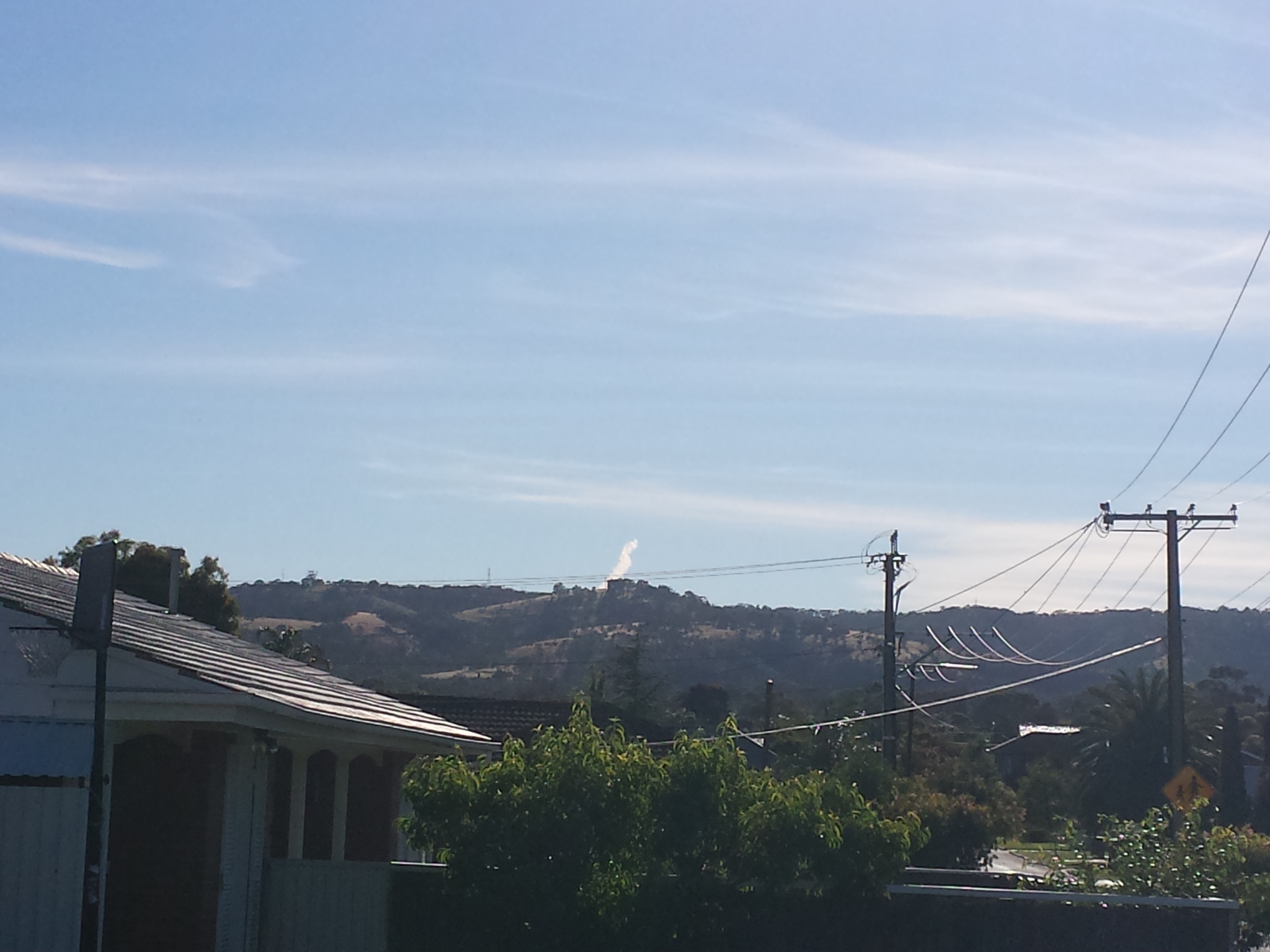
i am prepared to give out more information if needed! i would like to know what you think this is...
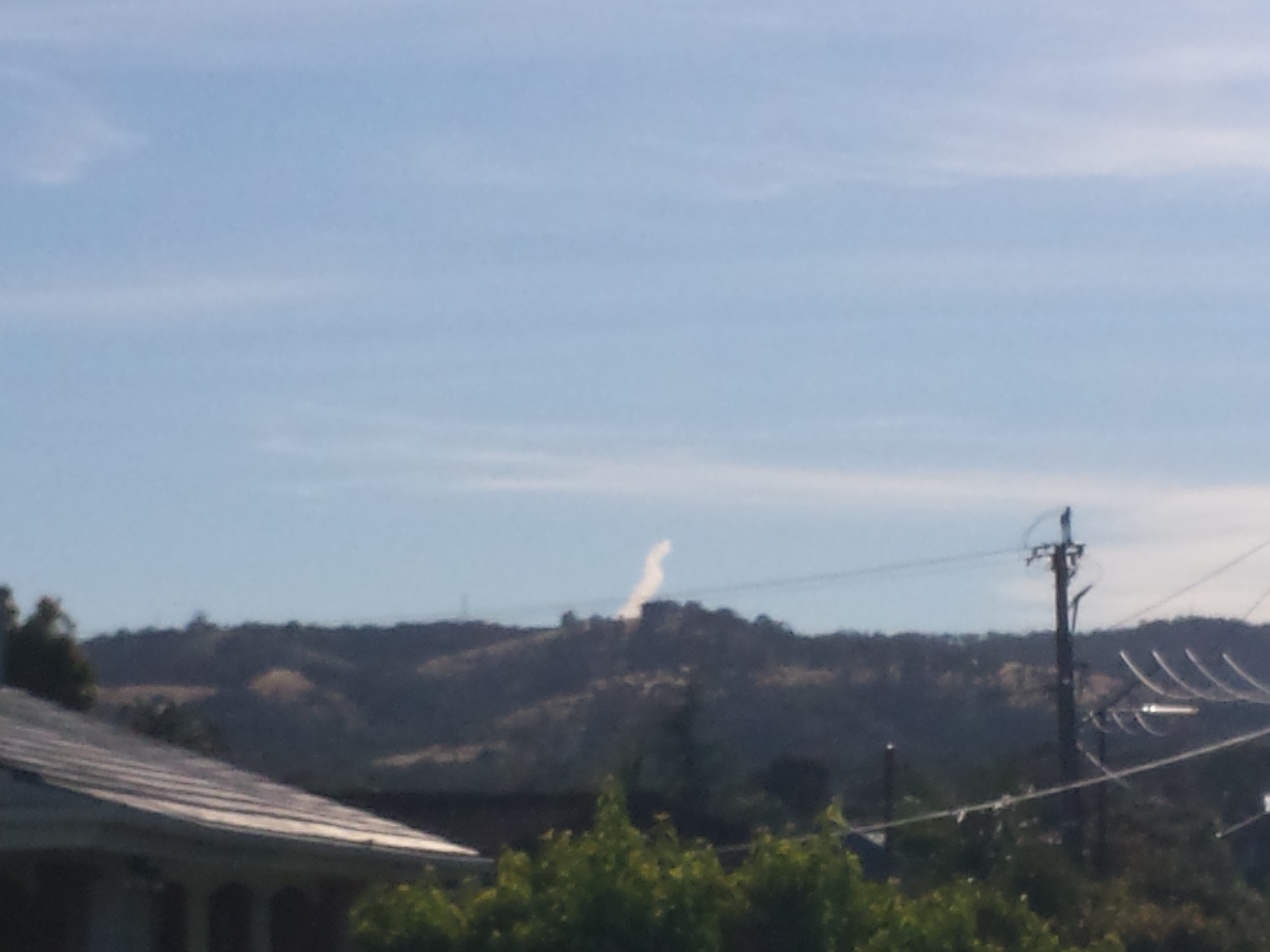
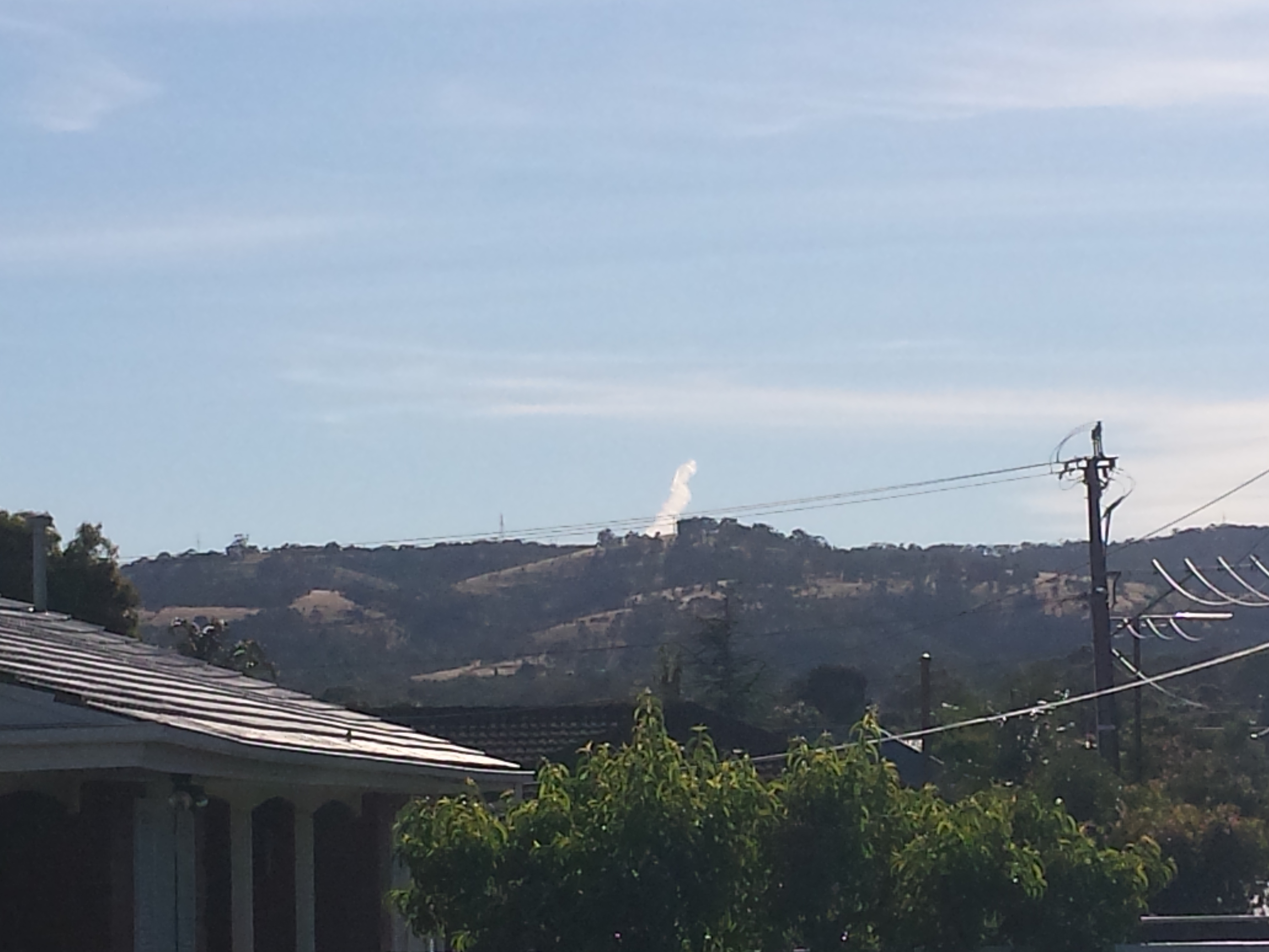
im watching what i think is a plane leave a thick luxurious trail behind it.
i have the usual internal debate, over whether i believe in chem-trails or not. still no result? oh well..
when wait a minute? its getting smaller!! i watch this thing shrink and shrink!
now im not idiot, i realise this is a static line of smoke/exhaust... the close i get to the hills the less i can see.
when i got to work i took the below photos where only the last bit of the tip is visible
it looks to me like rocket exhaust, or a missile trail... perhaps something entered the atmosphere and burned up...
anyway .. heres my first ever pics on ATS!
i am prepared to give out more information if needed! i would like to know what you think this is...
reply to post by okamitengu
Just a contrail of something either coming up from behind the mountains, or going behind them.
Just a contrail of something either coming up from behind the mountains, or going behind them.
reply to post by Zaphod58
im surprised by its sudden ending. thats all.
from further back it was a much longer trail .
im curious as to what its from as we dont get trails this thick around here...
like i said it looked like a rocket exhaust, i believe in the hills there, is a missile battery (rapier missile shield) not that i think thats what this is either. i genuinely dont know.
but any trail, i would expect to continue, or have a more obvious ending point (kaboom?)
ive seen many aircraft contrail. but not a thick one like this that just terminated.
i want to point i dont think this is a chemtrail, or a contrail but this forum is the only place that seemed to be about clouds...
reply to post by Zaphod58
Is it?
I'm not sure bt the OP describes it more than the image, and if it appeared like a contrail (or chemtrail if they must) then what I see looks a lot different to a contrail, it might be larger in appearance if the sun has caught it, but it looks much more like a rocket trail, as unlikely as I'd expect that in that location, having no more than the image to go on, to be sure..
Not saying it's anything crazy, but seems a bit off hand to proclaim it 'just a' when the OP did describe it a little differently to most contrails erroneously proposed as something that doesn't exist.
Also, who hit the power up? Everyone is running around with god mode hats on!! I never saw this!! lol.. unless you had one all along, I never noticed. But some others have them now too. Whisked away in the secrecy of night, beaten up with night sticks until compliant and sent back into the void, a newly formed member of the best team on the interwebs!!
reply to post by okamitengu
If he was descending, or climbing out of the region where contrails can form, it would just suddenly end like that. Sometimes they just end even though they are at the same altitude, because conditions are no longer right for them to occur.
A missile wouldn't leave a trail like that, it's too wide. T his is a SAM launch. You can see how thin the trail is. SAMs use pretty thin nozzles, and leave very thin trails.
A rocket would have continued long past that point.

winofiend
Whisked away in the secrecy of night, beaten up with night sticks until compliant and sent back into the void, a newly formed member of the best team on the interwebs!!
They kidnapped us a few weeks ago and waterboarded us until we agreed.
IMO the contrail looks thicker because it is old-ish and has expanded a bit. It is nice and thick (dense) because your view is foreshortened - ie
because of the low angle near the horizon you are looking along the length of it - so the effective thickness of the vapour is many miles deep.
It might be wispier if you were directly underneath and looking straight up at it and the thickness might only be a few hundred meters.
and lastly you see less of it as you get closer to the hill (if I am understanding you correctly) because you are further in the hill's "shadow" in respect of the contrail - ie as you get closer to the hill, it (the hill) hides more of the contrail that is low on the horizon.
okamitengu
it looks to me like rocket exhaust, or a missile trail... perhaps something entered the atmosphere and burned up...
Congrats on posting your first pic - here's some pages on other contrails that have looked like missiles from time to time
Contrails are usualy horizontal
LA "Missile" contrail
Another "missile" contrail
Living here in New Mexico next to White Sands Missile Range (Holloman AFB), that looks familiar. Every once in a while you can catch a glimpse of a
test launch from there. Possibly be a launch testing a booster stage. If you don't mind me asking, what part of the world did you see this at? Any
military or aerospace/aviation facilities in the area?
reply to post by geo1066
adelaide South australia.
nearest launching range would be woomera, i think thats about 800km away
the only thing missile like nearby is the rapier defense system at woodside army barracks
it just seemed more unusual than the contrail i see around here.
the picture doesn't do it justice, but it appeared fairly close to the hills. although based on my perspective of its trail (further away than up close) it couldn't have been. it wouldn't have "shrunk" behind the hills as i got closer.
i would be more inclined to think of even space junk burning up than the usual contrail.
i just dont know.
reply to post by okamitengu
Adelaide usually has good ADS-B coverage - what day and date was this, and roughly what heading is the contrail on?
Adelaide usually has good ADS-B coverage - what day and date was this, and roughly what heading is the contrail on?
edit on 3-11-2013 by
Aloysius the Gaul because: speling
reply to post by Aloysius the Gaul
it was friday 1/11/2013
it was approx 8:20 am and i was heading from west to east up grand junction road.... at point a on the directions below the trail took up about 1/6th of the sky
by point b, it was only just visible above the hills. as per original pictures.
Maps location headin A - B
the weather:
date min to 9am anomaly max from 9am anomaly rain to 9am
°C °C °C °C mm
Fri 01/11/2013 10.1 -4.0 31.1 +5.9 0.0
using streetview on that point A location the height of the trail was approx visible to the height of the closest visible street lamp on the right of frame.
the trail was headed from east to west.
any of that helpful?
edit on 11-3-13 by okamitengu because: missed heading of actual trail
okamitengu
reply to post by Aloysius the Gaul
it was friday 1/11/2013
it was approx 8:20 am and i was heading from west to east up grand junction road.... at point a on the directions below the trail took up about 1/6th of the sky
by point b, it was only just visible above the hills. as per original pictures.
Maps location headin A - B
using streetview on that point A location the height of the trail was approx visible to the height of the closest visible street lamp on the right of frame.
the trail was headed from east to west.
any of that helpful?
I was hoping to see if there was anything on Flight Radar 24 around that time - which I think is about 2320 hrs 31 Oct UTC if I have my time-zones right!
I am unsure what direction you are looking at but there are a couple of flights heading east-west north and south of Adelaide around that time that it might be - QFA 485 Mel-Per is over the bight at 40,000 ft, QFA575 Syd-Per has just passed about 100 miles north of Adelaide, height is not given.
reply to post by AbleEndangered
What would you guess it is if not a contrail ?
Yeah just a "Con"-trail...wink...
What would you guess it is if not a contrail ?
reply to post by tsurfer2000h
Maybe a test for any number of reasons, but I would think calculations can be amazingly accurate but a real life test is always the best way of getting the facts to a result for larger scale applications.
Or, maybe a test for the benefit of those whom swore to uphold the “ITS CONTRAILS LAWS”?
I LOVE CONTRAILS tattoo on the forehead or hand would be a nice addition to any dedicated contrail advocate.
reply to post by fireyaguns
I think you are right - establishing just how gullible chemtrail believers are requires field testing - the lab tests really dot' give the true picture.
I think you are right - establishing just how gullible chemtrail believers are requires field testing - the lab tests really dot' give the true picture.
new topics
-
Remember These Attacks When President Trump 2.0 Vengeance-Retribution Commences.
2024 Elections: 17 minutes ago -
Predicting The Future: The Satanic Temple v. Florida
Conspiracies in Religions: 25 minutes ago -
WF Killer Patents & Secret Science Vol. 1 | Free Energy & Anti-Gravity Cover-Ups
General Conspiracies: 2 hours ago -
Hurt my hip; should I go see a Doctor
General Chit Chat: 3 hours ago -
Israel attacking Iran again.
Middle East Issues: 4 hours ago -
Michigan school district cancels lesson on gender identity and pronouns after backlash
Education and Media: 4 hours ago -
When an Angel gets his or her wings
Religion, Faith, And Theology: 5 hours ago -
Comparing the theology of Paul and Hebrews
Religion, Faith, And Theology: 6 hours ago -
Pentagon acknowledges secret UFO project, the Kona Blue program | Vargas Reports
Aliens and UFOs: 7 hours ago -
Boston Dynamics say Farewell to Atlas
Science & Technology: 7 hours ago
top topics
-
The Democrats Take Control the House - Look what happened while you were sleeping
US Political Madness: 10 hours ago, 18 flags -
In an Historic First, In N Out Burger Permanently Closes a Location
Mainstream News: 12 hours ago, 16 flags -
Biden says little kids flip him the bird all the time.
Politicians & People: 10 hours ago, 9 flags -
Man sets himself on fire outside Donald Trump trial
Mainstream News: 9 hours ago, 9 flags -
Michigan school district cancels lesson on gender identity and pronouns after backlash
Education and Media: 4 hours ago, 7 flags -
WF Killer Patents & Secret Science Vol. 1 | Free Energy & Anti-Gravity Cover-Ups
General Conspiracies: 2 hours ago, 6 flags -
Pentagon acknowledges secret UFO project, the Kona Blue program | Vargas Reports
Aliens and UFOs: 7 hours ago, 6 flags -
Israel attacking Iran again.
Middle East Issues: 4 hours ago, 5 flags -
Boston Dynamics say Farewell to Atlas
Science & Technology: 7 hours ago, 4 flags -
Remember These Attacks When President Trump 2.0 Vengeance-Retribution Commences.
2024 Elections: 17 minutes ago, 3 flags
active topics
-
Predicting The Future: The Satanic Temple v. Florida
Conspiracies in Religions • 4 • : Sookiechacha -
In an Historic First, In N Out Burger Permanently Closes a Location
Mainstream News • 11 • : TheMisguidedAngel -
Remember These Attacks When President Trump 2.0 Vengeance-Retribution Commences.
2024 Elections • 3 • : KrustyKrab -
Michigan school district cancels lesson on gender identity and pronouns after backlash
Education and Media • 9 • : TheMisguidedAngel -
Mood Music Part VI
Music • 3064 • : MRTrismegistus -
Man sets himself on fire outside Donald Trump trial
Mainstream News • 41 • : TheMisguidedAngel -
The New, New ATS Members Photos thread. Part 3.
Members • 1653 • : zosimov -
A man of the people
Medical Issues & Conspiracies • 15 • : PrivateAngel -
Israel attacking Iran again.
Middle East Issues • 27 • : KrustyKrab -
I hate dreaming
Rant • 7 • : TheMichiganSwampBuck
3