It looks like you're using an Ad Blocker.
Please white-list or disable AboveTopSecret.com in your ad-blocking tool.
Thank you.
Some features of ATS will be disabled while you continue to use an ad-blocker.

Red Alert Issued - Indian East Coast - Super Cyclone PHAILINE
page: 3share:
reply to post by canucks555
I've been following this, watching it on and off for the last 36 hours. It is the best I can find so far:
www.ndtv.com...
5 lakh (500000) people now evacuated which is great news..... however looking at the integrity of some of the buildings in and around Odisha, this could be extremely destructive.
This is not an affluent area, fishing being a major contributor, so this storm is likely to destroy livelihoods, always seems to be the case.
edit on 12-10-2013 by Mufcutcakeyumyum because: (no reason given)
Reports now being broadcast from Andhra Pradesh of women refusing to leave due to their taking part in a religious festival which involves "holy
water" from the sea.
This report comes only a few metres from the coastline.....
WTF! get out of there.
This report comes only a few metres from the coastline.....
WTF! get out of there.
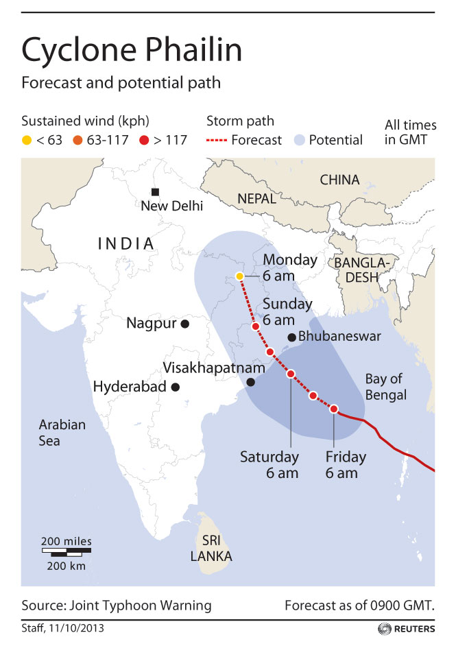
Landfall is only 2 hours away now.
I can't believe the lack of live coverage of what may turn out to be the largest cyclone in the Indian Ocean ever recorded - and now being called a super-cyclone.
I can't believe the lack of live coverage of what may turn out to be the largest cyclone in the Indian Ocean ever recorded - and now being called a super-cyclone.
reply to post by Mufcutcakeyumyum
Yup that is how I am reading it.
Unisys is a good source and has data going back decades.
Yup that is how I am reading it.
Unisys is a good source and has data going back decades.
edit on 12/10/2013 by PuterMan because: (no reason given)
reply to post by CranialSponge
Mainly because everything has to be 'super' these days! For some strange reason I have never quite determined the only reference to 'super' is attached to typhoons so we get Super Typhoons which can be Cat 5, and recently I have seen on at Cat 4 described as super.
Sandy in the US was described as a Super Hurricane - it was not by any stretch of the imagination and it only managed Cat 2 for a very brief period, but Hurricanes have never been given the designation Super as far as I am aware. Mind a Cat 5 hurricane could rightly be called that as they are rare beasts.
I seem to remember that the media and authorities in the US were panicking about Tropical Storm KAREN which was a rather limp depression that never managed above 55kts. Basically what we call a stiff breeze here on the West Coast.
weather.unisys.com...
PS PHAILIN is now Cat 4
and now being called a super-cyclone
Mainly because everything has to be 'super' these days! For some strange reason I have never quite determined the only reference to 'super' is attached to typhoons so we get Super Typhoons which can be Cat 5, and recently I have seen on at Cat 4 described as super.
Sandy in the US was described as a Super Hurricane - it was not by any stretch of the imagination and it only managed Cat 2 for a very brief period, but Hurricanes have never been given the designation Super as far as I am aware. Mind a Cat 5 hurricane could rightly be called that as they are rare beasts.
I seem to remember that the media and authorities in the US were panicking about Tropical Storm KAREN which was a rather limp depression that never managed above 55kts. Basically what we call a stiff breeze here on the West Coast.
Date: 03-06 OCT 2013
Tropical Storm KAREN
ADV LAT LON TIME WIND PR STAT
1 22.00 -87.60 10/03/13Z 50 1004 TROPICAL STORM
2 22.20 -87.90 10/03/15Z 55 1004 TROPICAL STORM
2A 22.90 -88.20 10/03/18Z 55 1004 TROPICAL STORM
3 23.30 -88.50 10/03/21Z 55 999 TROPICAL STORM
3A 23.80 -88.90 10/04/00Z 55 999 TROPICAL STORM
4 24.20 -89.00 10/04/03Z 55 999 TROPICAL STORM
4A 24.50 -89.50 10/04/06Z 55 999 TROPICAL STORM
5 24.90 -89.80 10/04/09Z 50 1002 TROPICAL STORM
5A 25.20 -90.00 10/04/12Z 50 1003 TROPICAL STORM
6 25.60 -90.20 10/04/15Z 45 1003 TROPICAL STORM
6A 25.80 -90.20 10/04/18Z 45 1003 TROPICAL STORM
7 25.90 -90.30 10/04/21Z 45 1003 TROPICAL STORM
7A 25.90 -90.30 10/05/00Z 45 1002 TROPICAL STORM
8 26.40 -90.50 10/05/03Z 40 1002 TROPICAL STORM
8A 26.70 -90.90 10/05/06Z 35 1004 TROPICAL STORM
9 27.10 -91.30 10/05/09Z 35 1007 TROPICAL STORM
9A 27.50 -91.50 10/05/12Z 35 1008 TROPICAL STORM
10 27.90 -91.70 10/05/15Z 35 1008 TROPICAL STORM
10A 27.90 -91.80 10/05/18Z 35 1009 TROPICAL STORM
11 28.10 -91.70 10/05/21Z 35 1007 TROPICAL STORM
11A 28.10 -91.70 10/06/00Z 35 1007 TROPICAL STORM
12 28.10 -91.90 10/06/03Z 30 1008 TROPICAL DEPRESSION
13 28.30 -91.70 10/06/09Z 25 1009 TROPICAL DEPRESSION
weather.unisys.com...
PS PHAILIN is now Cat 4
18.00 85.80 10/12/06Z 130 - CYCLONE-4
reply to post by PuterMan
Yes a stiff breeze is one thing, but we have many many different types of rain. Can we start calling our horizontal rain "super" rain?
Yes a stiff breeze is one thing, but we have many many different types of rain. Can we start calling our horizontal rain "super" rain?
reply to post by Mufcutcakeyumyum
praying for all out there. Bumping thread. Cant type much,on stupid phone.
praying for all out there. Bumping thread. Cant type much,on stupid phone.
edit on 12-10-2013 by thedoctorswife because: (no reason
given)
Ok looks like it is about to make landfall soon.
At present NDTV are doing good coverage and live updates etc.
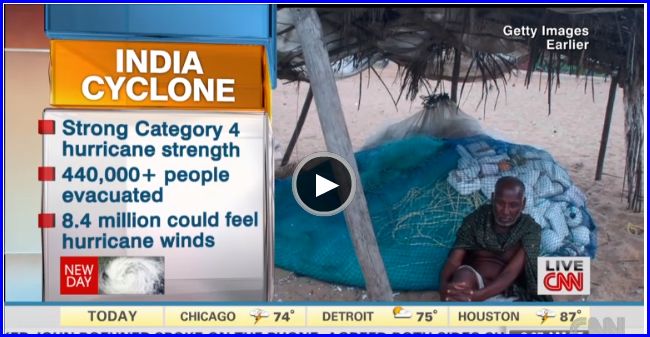
Over 5.5 lakh (550,000) people safely evacuated.
Thoughts are with the people there now..... be safe.
www.ndtv.com...
At present NDTV are doing good coverage and live updates etc.
Over 5.5 lakh (550,000) people safely evacuated.
Thoughts are with the people there now..... be safe.
www.ndtv.com...
edit on 12-10-2013 by Mufcutcakeyumyum because: (no reason given)
Indian govt. has finally upgraded the status to a cat 5 as the wind speeds are expected to cross 240 kmph easily. Whereas, US Naval research has
pipped it to cross cat 6 on landfall. Rumors are that the Indian METROLOGICAL department is deliberately giving lower estimates. I wonder why?
Reporters from Headlines Today are on the spot reporting live from Gopalpur, Mr. Jugal Hansraj and Mr. Rahul Kanwal are daring the cyclone to bring live pictures from the location.
Only bright spot as of now is that over 550000 people have been evacuated.
The super cyclone is now just about 15-20 kms from landfall. Roughly about 10-15 minutes from now i.e. 19:00 IST
edit on 12-10-2013 by UnknownEntity because: Spelling correction
edit on 12-10-2013 by UnknownEntity because: (no reason
given)
reply to post by UnknownEntity
Besides the 18 fishermen who are missing, first reports of casualty from costal villages emerge even before the cyclone has touched ground. 6 people are reported dead as multiple trees fell across North Andhra Pradesh costal areas.
Power is been cut across the costal areas. However now CNN is reporting that drier winds are pushing against the cyclone eye, this is good news, as it may result in reduced wind speeds as the cyclone touches land.
Keep praying friends...only prayers can help.
PuterMan
Mainly because everything has to be 'super' these days! For some strange reason I have never quite determined the only reference to 'super' is attached to typhoons so we get Super Typhoons which can be Cat 5, and recently I have seen on at Cat 4 described as super.
For an extra $2.00 we can Supersize it for you! The way of the USA.
All kidding aside I am concerned for the people, in that area, since they lack the shelter, and the understanding of how severe this storm is going to be during landfall.
edit on 12-10-2013 by Realtruth because: (no reason given)
reply to post by Realtruth
They seem pretty understanding of it to me from what I have been seeing. They certainly have more experience of them.
Taking on board what you say though, it isn't exactly an affluent area by any standards, so you make the most of what you can do. I am concerned more for the stoic (or insert your word of choice) people who have refused to leave their homes.
Not really having had first hand experience to compare it to, I would say they've done ok, but suppose we will soon see.
The storm seems to have stagnated just around 20km off shore, supposedly intensifying, which is why it hasn't officially landed yet.
Mufcutcakeyumyum
reply to post by Realtruth
They seem pretty understanding of it to me from what I have been seeing. They certainly have more experience of them.
Taking on board what you say though, it isn't exactly an affluent area by any standards, so you make the most of what you can do. I am concerned more for the stoic (or insert your word of choice) people who have refused to leave their homes.
Not really having had first hand experience to compare it to, I would say they've done ok, but suppose we will soon see.
The storm seems to have stagnated just around 20km off shore, supposedly intensifying, which is why it hasn't officially landed yet.
You would think that with that experience comes knowledge, but it doesn't appear to be so in this case.
The fact this storm has stalled, is bad JuJu, the longer it sits the worse it becomes.
Katrina stalled as well and we all know how that turned out.
PuterMan is their a formula for storms this size stalling to predict increased intensity?
PuterMan
Sandy in the US was described as a Super Hurricane - it was not by any stretch of the imagination and it only managed Cat 2 for a very brief period, but Hurricanes have never been given the designation Super as far as I am aware. Mind a Cat 5 hurricane could rightly be called that as they are rare beasts.
Except Sandy was called a Super Storm , not a super hurricane, for a multiple reasons.
1. Path it took
2. Amount of Damage
3. Loss of Life
The SS scale is not the only thing that determines how a storm should be categorized and everything about Sandy warranted being prefaced with Super.
en.wikipedia.org...
Phailin has just made landfall in Gopalpur as of a few minutes ago.
Mufcutcakeyumyum
Phailin has just made landfall in Gopalpur as of a few minutes ago.
Ugh..best of luck to the people dealing with that.
reply to post by UnknownEntity
Cyclone Phailin menaces India's coast, as hundreds of thousands flee
Cyclone Phailin Link
Live: strong winds, rains lash Odisha coast; Cyclone Phailin to hit land
Link to Updates:
Here are a few highlights from the bulletin:
Heavy winds
11am: Excerpts of press conference of LK Ratore, DG Cyclone Centre, IMD
* Cyclone Philain currently at 200km south-east of Gopalpur. 210-220 kmph winds expected. Heavy rains soon.
* Heavy to very heavy rainfall in entire Odisha expected when cyclone makes landfall
* Cyclone likely to hit between Kalingpatnam and Paradip at Gopalpur Saturday evening between 6-8pm.
* Cyclone Phailin will remain as severe cyclonic storm for 6 hours after it hits.
* Heavy rainfall in Odisha, Andhra. Rainfall also expected in Chhattisgarh and Bihar
* At the time of crossing coast, it will remain a cyclonic storm with speeds of 240 kmph will be experienced.
* Intensity of rains and wind in Odisha will increase as the day progresses.
I hope the people in India don't have too much problem with this storm.
UnknownEntity
US Naval research has pipped it to cross cat 6 on landfall.
Do you have a link for this, because there is no Category 6 for any hurricane or typhoon. The max is Cat. 5.
edit on 12-10-2013 by _BoneZ_ because: sp
new topics
-
Any one suspicious of fever promotions events, major investor Goldman Sachs card only.
The Gray Area: 46 minutes ago -
God's Righteousness is Greater than Our Wrath
Religion, Faith, And Theology: 5 hours ago -
Electrical tricks for saving money
Education and Media: 8 hours ago -
VP's Secret Service agent brawls with other agents at Andrews
Mainstream News: 9 hours ago -
Sunak spinning the sickness figures
Other Current Events: 10 hours ago -
Nearly 70% Of Americans Want Talks To End War In Ukraine
Political Issues: 10 hours ago
top topics
-
VP's Secret Service agent brawls with other agents at Andrews
Mainstream News: 9 hours ago, 9 flags -
Cats Used as Live Bait to Train Ferocious Pitbulls in Illegal NYC Dogfighting
Social Issues and Civil Unrest: 13 hours ago, 8 flags -
Electrical tricks for saving money
Education and Media: 8 hours ago, 4 flags -
HORRIBLE !! Russian Soldier Drinking Own Urine To Survive In Battle
World War Three: 17 hours ago, 3 flags -
Sunak spinning the sickness figures
Other Current Events: 10 hours ago, 3 flags -
Nearly 70% Of Americans Want Talks To End War In Ukraine
Political Issues: 10 hours ago, 3 flags -
Late Night with the Devil - a really good unusual modern horror film.
Movies: 12 hours ago, 2 flags -
The Good News According to Jesus - Episode 1
Religion, Faith, And Theology: 15 hours ago, 1 flags -
Any one suspicious of fever promotions events, major investor Goldman Sachs card only.
The Gray Area: 46 minutes ago, 1 flags -
God's Righteousness is Greater than Our Wrath
Religion, Faith, And Theology: 5 hours ago, 0 flags
active topics
-
HORRIBLE !! Russian Soldier Drinking Own Urine To Survive In Battle
World War Three • 34 • : Astyanax -
VP's Secret Service agent brawls with other agents at Andrews
Mainstream News • 42 • : 38181 -
Nearly 70% Of Americans Want Talks To End War In Ukraine
Political Issues • 15 • : Consvoli -
SETI chief says US has no evidence for alien technology. 'And we never have'
Aliens and UFOs • 55 • : Consvoli -
God's Righteousness is Greater than Our Wrath
Religion, Faith, And Theology • 4 • : randomuser2034 -
The Acronym Game .. Pt.3
General Chit Chat • 7746 • : bally001 -
Any one suspicious of fever promotions events, major investor Goldman Sachs card only.
The Gray Area • 1 • : BeyondKnowledge3 -
Terrifying Encounters With The Black Eyed Kids
Paranormal Studies • 75 • : FlyersFan -
Russia Ukraine Update Thread - part 3
World War Three • 5728 • : F2d5thCavv2 -
Electrical tricks for saving money
Education and Media • 5 • : BeyondKnowledge3