It looks like you're using an Ad Blocker.
Please white-list or disable AboveTopSecret.com in your ad-blocking tool.
Thank you.
Some features of ATS will be disabled while you continue to use an ad-blocker.

Red Alert Issued - Indian East Coast - Super Cyclone PHAILINE
page: 2share:
reply to post by UnknownEntity
I hope and pray thats the case. The worse cyclone in terms of deaths was cat 3 that hit Bangladesh in the 70s, 3 to 5 hundred thousand deaths. Kind of put things into perspective with this cat 5.
I hope and pray thats the case. The worse cyclone in terms of deaths was cat 3 that hit Bangladesh in the 70s, 3 to 5 hundred thousand deaths. Kind of put things into perspective with this cat 5.
I am sure you know, but this is NDTV 24x7, Indian TV channel. Nothing specific at the moment, just the live strapline across the bottom......
www.ndtv.com...
Might be worth an eye on as time gets closer...
www.ndtv.com...
Might be worth an eye on as time gets closer...
If you compare the recent update today to the figures recorded yesterday at around the same time, this thing is gaining a lot of momentum.......
hisz.rsoe.hu...
Particularly wave size and wind / gusts. Course is still fairly steady.
hisz.rsoe.hu...
Particularly wave size and wind / gusts. Course is still fairly steady.
Indian man on the tv was saying they are not expecting a large loss of life.. looks like a cat 3 now..
hope hes right..
hope hes right..
reply to post by Mufcutcakeyumyum
weather.unisys.com...
Date: 09-11 OCT 2013
Cyclone-5 PHAILIN
ADV LAT LON TIME WIND PR STAT
1 13.20 93.40 10/09/00Z 35 - TROPICAL STORM
2 13.40 92.80 10/09/06Z 40 - TROPICAL STORM
3 13.70 92.20 10/09/12Z 40 - TROPICAL STORM
4 14.10 91.60 10/09/18Z 50 - TROPICAL STORM
5 14.40 91.30 10/10/00Z 55 - TROPICAL STORM
6 14.90 91.00 10/10/06Z 65 - CYCLONE-1
7 15.40 90.30 10/10/12Z 100 - CYCLONE-3
8 15.60 89.40 10/10/18Z 125 - CYCLONE-4
9 15.80 88.80 10/11/00Z 135 - CYCLONE-4
10 16.10 88.40 10/11/06Z 135 - CYCLONE-4
11 16.70 87.70 10/11/12Z 140 - CYCLONE-5
+12 17.70 86.40 10/12/00Z 145 - CYCLONE-5
+24 19.00 85.10 10/12/12Z 130 - CYCLONE-4
+36 20.30 84.00 10/13/00Z 100 - CYCLONE-3
+48 22.10 83.10 10/13/12Z 65 - CYCLONE-1
+72 24.80 82.20 10/14/12Z 30 - TROPICAL DEPRESSION
weather.unisys.com...
reply to post by PuterMan
Hi Puterman, thanks for the alternative source. You are vastly more learned than me so am I right in deducing that this will intensify through to tomorrow then weaken from second half of tomorrow onwards?
The latest on the TV channel doesn't seem too stricken but it does seem like a big deal especially as the land there is so densely populated. I know evacuations are underway etc but still.
What's weird to me is how little this is being talked about. It's almost invisible on social media here in the U.S, at least from what I can see.
Even on ATS, this is the only thread about this.
And yet it's huge. Potentially catastrophic, and nothing.
People are all about predicting doom, but when it's actually happening, nothing?
And yet it's huge. Potentially catastrophic, and nothing.
People are all about predicting doom, but when it's actually happening, nothing?
reply to post by Inannamute
I have been following this all day, am now watching NDTV 24x7 Indian TV. They are currently debating if they are ready. A meteorologist, Eric Holthaus is currently saying it is potentially worse than the one in 1999.
Thankfully it seems that evacuation plans are well underway so hopefully it can be ridden out as safely as possible.
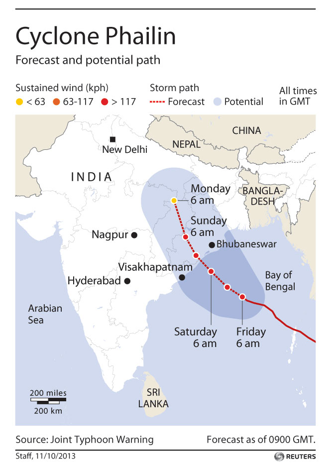
Reuters.com: Cyclone Phailin threatens 12 million, says disaster authority
Link: Reuters.com
I hope alot of people got/get the news on time over there.
Link: Reuters.com
I hope alot of people got/get the news on time over there.
reply to post by coolism
Im just sat in my living room depressed.
We must pray or beleive this from your link.
India's disaster preparedness has improved dramatically in recent years, and aid workers praised precautions taken by authorities for Phailin such as early warning, pre-positioning of rations in shelters and orderly evacuations.
Infrared satellite pic of storm closing in on coastline that just came over twitter. THAT is huge and very ugly!

The Indian Meteorological Department warned that Phailin was a "very severe cyclonic storm" that was expected to hit with maximum sustained winds of 210-220 kilometres per hour. However, the U.S. Navy's Joint Typhoon Warning Center in Hawaii forecast maximum sustained winds of 269 km/h with gusts up to 315 km/h. U.S. meteorologists said the storm is flirting with historic power. "If it's not a record it's really, really close,"
www.cbc.ca...
Bumping this up, because it deserves the attention. I've never seen a satellite image where the wind speed was depicted by black. Crazy. Praying
for the people of India.
whoa that is one big mother of a storm......stay safe people of india
sounds like we need some storm chasers on the ground for some updates....
sounds like we need some storm chasers on the ground for some updates....
Latest Update as of 04:00am e.s.t
Live Hourly Updates Here
Cyclone Phailin forces tens of thousands to flee northeast India
So at this hour, thankfully there has been significant information and time to make preparations for the potential catastrophic natural disaster. However, certainly there will be a lot of infrastructure damage that will rise into the billions of dollars. As thousands flee the coastal area, there is still fear that many may not have had the time or means to evacuate.
Damage expected
* Extensive damage expected to kutcha houses, some damage to old buildings.
* Large scale disruption of power and communication lines.
* Disruption of rail and road traffic due to extensive flooding.
* Potential threat from flying debris.
* Flooding of escape routes.
* Extensive damage to agricultural crops.
Additional advisory:
* Mobilise evacuation from coastal areas.
* Judicious regulation of rail and road traffic.
* People in affected areas to remain indoors during cyclone landfall.
Live Hourly Updates Here
Up To The Moment Link Here
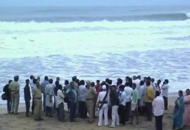
Srikakulam: As many as 52,000 locals were today evacuated and 25,000 people accommodated in cyclone shelters in Srikakulam district in view of Cyclone Phailin which is expected to cross the shore by this evening.
Cyclone Phailin forces tens of thousands to flee northeast India
Cyclone Phailin, the most powerful storm to take aim at northeastern India since 1999, forced the evacuation of tens of thousands along the Bay of Bengal coastline as it threatened to flood escape routes, disrupt rail service and cut off power for weeks.
Phailin, which means “sapphire” in Thai, has winds of 135 mph and was expected to make landfall about 6 p.m. local time Saturday, according to L.S. Rathore, director-general of the India Meteorological Department. The U.S. Navy’s Joint Typhoon Warning Center in Hawaii estimated Phailin’s top winds at 161 mph, a Category 5 on the U.S. hurricane scale, which is different than the one used by the rest of the world. Hurricane Andrew in 1992, was a Category 5 storm.
Phailin sent at least 64,000 people fleeing from their homes and forced ships out of its path, and is expected to cause crop and infrastructure damage. Twenty-six of the world’s 35 deadliest tropical cyclones, the storms that include hurricanes and typhoons, have occurred in the Bay of Bengal
So at this hour, thankfully there has been significant information and time to make preparations for the potential catastrophic natural disaster. However, certainly there will be a lot of infrastructure damage that will rise into the billions of dollars. As thousands flee the coastal area, there is still fear that many may not have had the time or means to evacuate.
Does anyone have a link to an India live feed that's following this story? I found this site:
zeenews.india.com...
very informative but the news feed that works is not in English.
zeenews.india.com...
very informative but the news feed that works is not in English.
reply to post by canucks555
That's what I've been trying to find for the past hour or so, with no luck.
Hopefully someone can find an english live feed...
This behemoth is unbelievable.
There's going to be tens of thousands of displaced people in the aftermath, my gawd.
That's what I've been trying to find for the past hour or so, with no luck.
Hopefully someone can find an english live feed...
This behemoth is unbelievable.
There's going to be tens of thousands of displaced people in the aftermath, my gawd.
ItDepends
Latest Update as of 04:00am e.s.t
Damage expected
* Extensive damage expected to kutcha houses, some damage to old buildings.
* Large scale disruption of power and communication lines.
* Disruption of rail and road traffic due to extensive flooding.
* Potential threat from flying debris.
* Flooding of escape routes.
* Extensive damage to agricultural crops.
Additional advisory:
* Mobilise evacuation from coastal areas.
* Judicious regulation of rail and road traffic.
* People in affected areas to remain indoors during cyclone landfall.
Live Hourly Updates Here
Up To The Moment Link Here
Srikakulam: As many as 52,000 locals were today evacuated and 25,000 people accommodated in cyclone shelters in Srikakulam district in view of Cyclone Phailin which is expected to cross the shore by this evening.
Cyclone Phailin forces tens of thousands to flee northeast India
Cyclone Phailin, the most powerful storm to take aim at northeastern India since 1999, forced the evacuation of tens of thousands along the Bay of Bengal coastline as it threatened to flood escape routes, disrupt rail service and cut off power for weeks.
Phailin, which means “sapphire” in Thai, has winds of 135 mph and was expected to make landfall about 6 p.m. local time Saturday, according to L.S. Rathore, director-general of the India Meteorological Department. The U.S. Navy’s Joint Typhoon Warning Center in Hawaii estimated Phailin’s top winds at 161 mph, a Category 5 on the U.S. hurricane scale, which is different than the one used by the rest of the world. Hurricane Andrew in 1992, was a Category 5 storm.
Phailin sent at least 64,000 people fleeing from their homes and forced ships out of its path, and is expected to cause crop and infrastructure damage. Twenty-six of the world’s 35 deadliest tropical cyclones, the storms that include hurricanes and typhoons, have occurred in the Bay of Bengal
So at this hour, thankfully there has been significant information and time to make preparations for the potential catastrophic natural disaster. However, certainly there will be a lot of infrastructure damage that will rise into the billions of dollars. As thousands flee the coastal area, there is still fear that many may not have had the time or means to evacuate.
My prayers and fervent wishes for the poor people trapped in the path of this natural behemoth-the poor in their fragile shacks,the children.This is another reminder-we live off/on Her,not She off Us-mother nature will always have the last word,not humans,no matter how advanced our technologies+achievements.I am going to be watching this one-with hope in my heart that the most vulnerable gets through this with minimum casualties.Very worrying indeed,I really feel for those people.
As of 1400 IST...Phailin is just 150 kms from the coast. The local news channels have stated dramatic winds already being felt in costal villages.
This cyclone is expected to be one of the strongest in ages to hit the Indian east coast and is already equal in power to the 1999 cyclone which
killed over 10000 people.
Already there are reports of at least 18 fishermen lost at sea and many more are feared trapped.
Already there are reports of at least 18 fishermen lost at sea and many more are feared trapped.
new topics
-
Former Labour minister Frank Field dies aged 81
People: 22 minutes ago -
SETI chief says US has no evidence for alien technology. 'And we never have'
Aliens and UFOs: 2 hours ago -
This is our Story
General Entertainment: 4 hours ago -
President BIDEN Vows to Make Americans Pay More Federal Taxes in 2025 - Political Suicide.
2024 Elections: 6 hours ago -
Ode to Artemis
General Chit Chat: 7 hours ago -
Ditching physical money
History: 11 hours ago -
One Flame Throwing Robot Dog for Christmas Please!
Weaponry: 11 hours ago -
Don't take advantage of people just because it seems easy it will backfire
Rant: 11 hours ago
top topics
-
University student disciplined after saying veganism is wrong and gender fluidity is stupid
Education and Media: 15 hours ago, 14 flags -
President BIDEN Vows to Make Americans Pay More Federal Taxes in 2025 - Political Suicide.
2024 Elections: 6 hours ago, 10 flags -
One Flame Throwing Robot Dog for Christmas Please!
Weaponry: 11 hours ago, 6 flags -
Should Biden Replace Harris With AOC On the 2024 Democrat Ticket?
2024 Elections: 13 hours ago, 6 flags -
Don't take advantage of people just because it seems easy it will backfire
Rant: 11 hours ago, 4 flags -
Ditching physical money
History: 11 hours ago, 4 flags -
SETI chief says US has no evidence for alien technology. 'And we never have'
Aliens and UFOs: 2 hours ago, 3 flags -
Ode to Artemis
General Chit Chat: 7 hours ago, 3 flags -
God lived as a Devil Dog.
Short Stories: 16 hours ago, 3 flags -
VirginOfGrand says hello
Introductions: 12 hours ago, 2 flags
active topics
-
Former Labour minister Frank Field dies aged 81
People • 2 • : Freeborn -
Terrifying Encounters With The Black Eyed Kids
Paranormal Studies • 72 • : Consvoli -
The Superstition of Full Moons Filling Hospitals Turns Out To Be True!
Medical Issues & Conspiracies • 24 • : angelchemuel -
SETI chief says US has no evidence for alien technology. 'And we never have'
Aliens and UFOs • 13 • : andy06shake -
"We're All Hamas" Heard at Columbia University Protests
Social Issues and Civil Unrest • 266 • : KrustyKrab -
Russia Ukraine Update Thread - part 3
World War Three • 5720 • : Freeborn -
University student disciplined after saying veganism is wrong and gender fluidity is stupid
Education and Media • 32 • : BedevereTheWise -
So this is what Hamas considers 'freedom fighting' ...
War On Terrorism • 227 • : HopeForTheFuture -
Remember These Attacks When President Trump 2.0 Retribution-Justice Commences.
2024 Elections • 51 • : Justoneman -
British TV Presenter Refuses To Use Guest's Preferred Pronouns
Education and Media • 131 • : FlyersFan