It looks like you're using an Ad Blocker.
Please white-list or disable AboveTopSecret.com in your ad-blocking tool.
Thank you.
Some features of ATS will be disabled while you continue to use an ad-blocker.

Red Alert Issued - Indian East Coast - Super Cyclone PHAILINE
page: 1share:
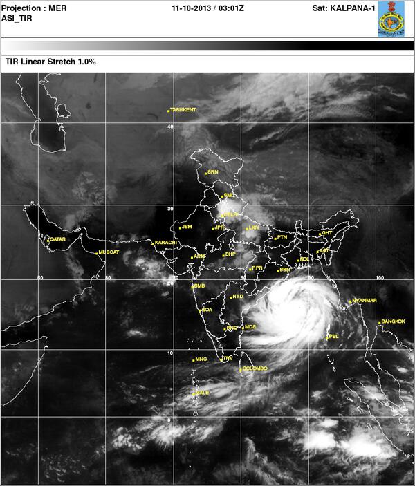
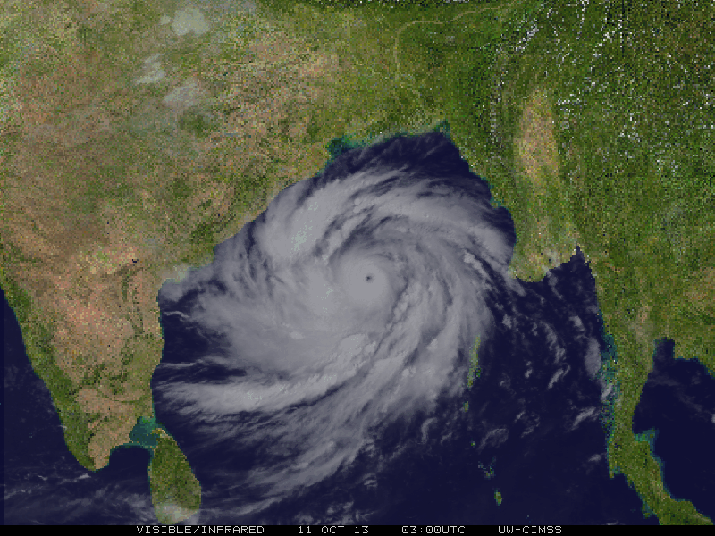
The Indian Government has put the entire East Coast of India on Red Alert, as Cyclone Phailine has now developed into a Super Cyclone (CAT 5) with
wind speeds picking upto 215 KMPH.
The Indian Defense Minister has asked the Indian Army, Navy and Air Force to be on alert for relief and rescue operations.
I see this Super Cyclone Phailine could bring in huge disaster and calamities in the Indian Costal States of Andhra Pradesh and Odisha.
Phailine Storm Tracker
WSJ
Cyclone Phalin More Than Half of India in Size
"An atmospheric beast is forming in the Bay of Bengal and heading straight for India. Cyclone Phailin—pronounced pie-leen; it’s a Thai word for “sapphire”—has exploded from tropical storm strength to potentially the equivalent of a category 5 hurricane.
+
Meteorologists can’t precisely determine Phailin’s current strength because there are no “hurricane hunter“ aircraft taking direct measurements of storms in the Indian Ocean basin. The Joint Typhoon Warning Center (JTWC), a Hawaii-based forecasting outpost of the US Navy, says Phailin is undergoing “extreme rapid intensification.”
While strengthening, the storm has grown to nearly half the size of India itself. The storm’s growth, both in size and in strength, is expected to continue until landfall. The latest forecasts show Phailin hitting land on Saturday near Brahmapur, India."
Keep an eye on this one folks...this is big and could turn deadly. Prayers!
This cyclone, on par with Hurricane Katrina, is HUGE. Couple that with the already saturated eastern Indian soil from the recent storm season and the
huge population of Bangladesh.... you get a VERY impactive flood. It's a death storm for sure.
edit on 11/10/2013 by Iamonlyhuman because: (no reason given)
reply to post by UnknownEntity
People in India, please be smart and leave! Don't be "that person".....It won't end well. Just leave until the storm is over if you value self preservation! You have fair warning if it isn't hitting until tomorrow..
Take a page out of the Katrina notebook and don't just hang around thinking everything will be okay! My prayers go out to everyone there, I hope everyone stays safe!!
It's a shame how little attention this thread is getting; this is very big and very dangerous and will probably end badly.
Clearly it's in the wrong geographical area to care about.
Clearly it's in the wrong geographical area to care about.
reply to post by khimbar
No oil, just call centers, so not important. *obvious sarcasm*
-----
Im shocked by the magnitude of it, i should visit some Indian news place to get good information.
It seems to be moving North hmmm, if it goes south, Sri Lanka would be off the map.
No oil, just call centers, so not important. *obvious sarcasm*
-----
Im shocked by the magnitude of it, i should visit some Indian news place to get good information.
It seems to be moving North hmmm, if it goes south, Sri Lanka would be off the map.
edit on 10/11/2013 by luciddream because: (no reason given)
Latest I've seen on this is that it will be making landfall on the heavily populated north-eastern portion of India. Strength to be what we would
consider a CAT. 4 hurricane with winds of 160 mph. On Sat. morning (10/12). Could be very bad . Hopefully loss of life can be kept to a minimum but
historically this is usually not the case.
reply to post by Godfather1965
Yes, I have been looking at this for a little while now. The HinduTimes covered it, and so far the RSOE have this on it:
hisz.rsoe.hu...
Looks pretty mean, and in a hugely populated area:
www.thehindu.com...
The good news if there can be any is that people seem to be well into preparedness measure. Let's hope so.
reply to post by Iamonlyhuman
IMD HAS RELEASED THIS 2ND BULLETIN
Time of issue: 1600 hours IST Dated: 11-10-2013
Bulletin No.: BOB 04/2013/24 (Orange Message)
Sub: Very Severe Cyclonic Storm, PHAILIN over Central Bay of Bengal:
Cyclone Warning for North Andhra Pradesh and Odisha Coast.
The very severe cyclonic storm, PHAILIN over east central Bay of Bengal moved northwestwards and lay centred at 1430 hrs IST of 11thth October 2013 over west central and adjoining Bay of Bengal near latitude 16.50N and longitude 88.00E, about 440 km south-southeast of Paradip, 450 km southeast of Gopalpur, and 448 km east-southeast of Kalingapatnam. It would move northwestwards and cross north Andhra Pradesh and Odisha coast between Kalingapatnam and Paradip, close to Gopalpur (Odisha) by evening of 12thth October, 2013 as a very severe cyclonic storm with a maximum sustained wind speed of 210-220 kmph.
Based on latest analysis with NWP models and other conventional techniques, estimated track and intensity of the system are given in the Table below:
Date/Time(IST)
Position
(Lat. 0N/ Long. 0E)
Sustained maximum surface
wind speed (kmph)
Category
11-10-2013/1430
16.5/88.0
210-220 gusting to 235
Very Severe Cyclonic Storm
11-10-2013/1730
17.0/87.6
210-220 gusting to 235
Very Severe Cyclonic Storm
11-10-2013/2330
17.6/86.9
210-220 gusting to 235
Very Severe Cyclonic Storm
12-10-2013/0530
18.2/86.2
210-220 gusting to 235
Very Severe Cyclonic Storm
12-10-2013/1130
18.6/85.5
210-220 gusting to 235
Very Severe Cyclonic Storm
12-10-2013/1730
19.1/84.8
210-220 gusting to 235
Very Severe Cyclonic Storm
13-10-2013/0000
19.8/84.4
90-100 gusting to 110
Severe Cyclonic Storm
13-10-2013/1200
20.5/84.0
50-60 gusting to 70
Deep Depression
(A)Warning for Odisha, Andhra Pradesh and West Bengal
(i)Heavy Rainfall: Under the influence of this system, rainfall at most places with heavy to very heavy falls at a few places with isolated extremely heavy falls (≥ 25cm) would occur over coastal Odisha commencing from 11thth October 2013 night. It would continue and extend to interior Odisha from 12thth night. Rainfall at most places with isolated heavy to very heavy falls would also occur over north coastal Andhra Pradesh commencing from 11thth Oct. night. Isolated heavy to very heavy rainfall would occur over coastal areas of West Bengal commencing from 12thth Oct. night.
(ii)Gale wind: Squally winds speed reaching 45-55 kmph gusting to 65 kmph would prevail along and off Odisha and north Andhra Pradesh coast during next 12 hrs. It would increase in intensity thereafter with gale wind speed reaching 210-220 kmph along and off coastal districts of north coastal Andhra Pradesh and south Odisha at the time of landfall. State of Sea along and off Odisha and north Andhra Pradesh coast will be rough to very rough and will become gradually phenomenal on 12thth October 2013. It will be rough to very rough along and off West Bengal coast during the above period.
(iii)Storm Surge Guidance: Storm surge with height of around 3.0 m above astronomical tide would inundate low lying areas of Ganjam, Khurda, Puri and Jagatsinghpur districts of Odisha and Srikakulam district of Andhra Pradesh during landfall.
(iv)Damage expected over Odisha and adjoining north Andhra Pradesh: Extensive damage to kutcha houses. Some damage to old buildings. Large scale disruption of power and communication lines. Disruption of rail and road traffic due to extensive flooding. Potential threat from flying debris. Flooding of escape routes. Extensive damage to agricultural crops.
(v)Action suggested: Fishermen out at sea along north Andhra Pradesh, Odisha and West Bengal coast are advised to return to coast. Fishermen are advised not to venture into sea. Total suspension of fishing operations. Mobilise evacuation from coastal areas. Judicious regulation of rail and road traffic. People in affected areas to remain indoors during cyclone landfall.
The next bulletin will be issued at 2030 hrs IST of today, the 11thth October, 2013.
reply to post by Chrisfishenstein
You are absolutely on spot with that...people need to evacuate immediately...although, sadly, those are less developed parts - North Andhra and South Odisha States, and villagers/fishermen may stick around in their weak and meager huts, which I fear will not survive at all when the Cyclone hits ground at 200-225 kmph.
Disaster Management teams have been prepared, however, all news sources say is about 'post-cyclone' management/rescue mission by the Indian Armed Forces. Since the affected area is so large and wide, total evacuation is impossible...I am already grim about tomorrow and the day after.
Only a Miracle can save the fishermen-villages in those remote and non-developed areas.
I pray for all the people affected . I hope Bangladesh is spared. Star and flag.
edit on 11-10-2013 by symptomoftheuniverse because:
spelling
A deadly super-cyclone in 1999 killed more than 10,000 people in Orissa.
The army is on standby in the two states for emergency and relief operations.
Officials said helicopters and food packages were ready to be dropped in the storm-affected areas.
This could be devastating
My thoughts are with them.
link
reply to post by UnknownEntity
Wow that is scarry stuff there. Having been in India 7 years ago I understand the peril they are in. I think of the destruction we get here in America when storms of this calipur strikes and our housing is much superior than the billions of shantis or huts built sporadically throughout the country. I pray for the safety of all those in this storms path but fear the aftermath with be devistating if it hits at a CAT5.
Wow that is scarry stuff there. Having been in India 7 years ago I understand the peril they are in. I think of the destruction we get here in America when storms of this calipur strikes and our housing is much superior than the billions of shantis or huts built sporadically throughout the country. I pray for the safety of all those in this storms path but fear the aftermath with be devistating if it hits at a CAT5.
India is so densely populated, I hope the best for them.
I wonder what china is thinking about this? do you think that china will help and render any aid? or maybe the US even?
I hope for whatever happens, they come out on top of this.
I wonder what china is thinking about this? do you think that china will help and render any aid? or maybe the US even?
I hope for whatever happens, they come out on top of this.
This could be really really bad !! The population over there is so dense and they suffer
a lot every day, let alone have this added to their problems.
a lot every day, let alone have this added to their problems.
A storm like this killed 10 thousand in the 90s. I dont think the hurricanes in the usa kill as many.
This has spoilt my weekend.
This has spoilt my weekend.
Arnie123
I wonder what china is thinking about this? do you think that china will help and render any aid? or maybe the US even?
India has a track record of refusing aid....
that said, I received this a minute ago through work channels:
The locations affected by this alert are:
• Metro Manila
• Subic Bay Freeport Zone (Olongapo City)
• Clark Freeport Zone (Angeles City)
• Baguio
• Boracay
• Legazpi City
• Calamba City
• Batangas City
• Laoag City
• Tuguegarao City
Storm Details (1100 PHT Oct. 11)
• Center of Circulation: Philippine Sea, about 308 km (191 miles) east-northeast of Metro Manila
• Maximum Sustained Winds: 100 kts (185 kph, 115 mph)
• Projected Landfall (Date): Baler, Aurora Province, Luzon Island (late Oct. 11 or early Oct. 12)
• Affected Areas: Luzon region
Tropical Storm Santi (24W; international name: Nari) rapidly strengthened further to maximum sustained winds of 100 kts (185 kph, 115 mph) in the Philippine Sea Oct. 11. The system is expected to make landfall close to Baler, Aurora Province, on Luzon Island late Oct. 11 or early Oct. 12 (map).
Expect very heavy precipitation throughout most of the central and northern Luzon region, including Metro Manila. The rapid movement of the storm could limit overall rainfall totals, but widespread flash and areal flooding is likely, especially in areas close to the center of circulation. The threat of landslides will be high in the Zambales Mountains and the Sierra Madre and Cordillera Central ranges. Urban flooding is possible in low-lying parts of cities throughout the region. The storm will also enhance the southwest monsoon and bring heavy rainfall to western parts of the country in the Luzon and Visayas regions over the next several days. This could lead to more problems in flood-hit areas in central and western Visayas provinces. As of Oct. 11, gale warnings were in effect for the eastern coast of Cagayan in Northern Luzon, as well as the Samar and Leyte provinces in the Eastern Visayas region.
Public Storm Warnings (1100 PHT Oct. 11)
• Signal No. 3 (winds of 101-185 kph within 18 hours): Aurora, Isabela, Quirino, Ifugao, Nueva Viscaya, Benguet, Nueva Ecija
• Signal No. 2 (winds of 61-100 kph within 24 hours): La Union, Pangasinan, Ilocos Norte, Ilocos Sur, Cagayan, Apayao, Kalinga, Abra, Mt. Province, Tarlac, Zambales, Bulacan, Pampanga, Northern Quezon, Polilio Island
• Signal No. 1 (winds of 30-60 kph within 36 hours): Metro Manila, Calayan and Babuyan Group of Islands, Bataan, Rizal, Cavite, Batangas, Laguna, Lubang Islands, Rest of Quezon, Marinduque, Camarines, Provinces, Albay, Catanduanes
reply to post by symptomoftheuniverse
I think the cyclone will move further south than expected and land fall could be more towards Northern Andhra than Southern Odisha. Hopefully Bangladesh will be spared, they have already suffered badly from major storms. However, I am not too hopeful about the Northern Andhra belt. This looks monstrous, with the 'EYE' that looks like its alive!
I think the cyclone will move further south than expected and land fall could be more towards Northern Andhra than Southern Odisha. Hopefully Bangladesh will be spared, they have already suffered badly from major storms. However, I am not too hopeful about the Northern Andhra belt. This looks monstrous, with the 'EYE' that looks like its alive!
I just heard on the weather channel a bit ago that this should make landfall as an equivalent category 3 hurricane in the Odhissa region. It's about
the size of Illinois with the population of California. They have already evacuated about 40,000 people.
40,000? Doesn't look very hopeful for them over there. They say the land profile is alot like what New Orleans and the storm surge could likely push 12 miles inland. They be effed.
So many very, very poor people and I imagine the 40,000+ evacuated are people with means.
40,000? Doesn't look very hopeful for them over there. They say the land profile is alot like what New Orleans and the storm surge could likely push 12 miles inland. They be effed.
So many very, very poor people and I imagine the 40,000+ evacuated are people with means.
new topics
-
This is our Story
General Entertainment: 2 hours ago -
President BIDEN Vows to Make Americans Pay More Federal Taxes in 2025 - Political Suicide.
2024 Elections: 4 hours ago -
Ode to Artemis
General Chit Chat: 5 hours ago -
Ditching physical money
History: 8 hours ago -
One Flame Throwing Robot Dog for Christmas Please!
Weaponry: 8 hours ago -
Don't take advantage of people just because it seems easy it will backfire
Rant: 9 hours ago -
VirginOfGrand says hello
Introductions: 9 hours ago -
Should Biden Replace Harris With AOC On the 2024 Democrat Ticket?
2024 Elections: 10 hours ago
top topics
-
University student disciplined after saying veganism is wrong and gender fluidity is stupid
Education and Media: 12 hours ago, 12 flags -
Police clash with St George’s Day protesters at central London rally
Social Issues and Civil Unrest: 15 hours ago, 9 flags -
President BIDEN Vows to Make Americans Pay More Federal Taxes in 2025 - Political Suicide.
2024 Elections: 4 hours ago, 9 flags -
TLDR post about ATS and why I love it and hope we all stay together somewhere
General Chit Chat: 16 hours ago, 7 flags -
Should Biden Replace Harris With AOC On the 2024 Democrat Ticket?
2024 Elections: 10 hours ago, 6 flags -
Don't take advantage of people just because it seems easy it will backfire
Rant: 9 hours ago, 4 flags -
One Flame Throwing Robot Dog for Christmas Please!
Weaponry: 8 hours ago, 4 flags -
God lived as a Devil Dog.
Short Stories: 14 hours ago, 3 flags -
Ditching physical money
History: 8 hours ago, 3 flags -
VirginOfGrand says hello
Introductions: 9 hours ago, 2 flags
active topics
-
President BIDEN Vows to Make Americans Pay More Federal Taxes in 2025 - Political Suicide.
2024 Elections • 4 • : 727Sky -
University student disciplined after saying veganism is wrong and gender fluidity is stupid
Education and Media • 25 • : Consvoli -
British TV Presenter Refuses To Use Guest's Preferred Pronouns
Education and Media • 128 • : Consvoli -
Terrifying Encounters With The Black Eyed Kids
Paranormal Studies • 70 • : burritocat -
Tucker Carlson UFOs are piloted by spiritual entities with bases under the ocean and the ground
Aliens and UFOs • 42 • : Jukiodone -
The Fight for Election Integrity Continues -- Audits, Criminal Investigations, Legislative Reform
2024 Elections • 4143 • : Station27 -
-@TH3WH17ERABB17- -Q- ---TIME TO SHOW THE WORLD--- -Part- --44--
Dissecting Disinformation • 636 • : F2d5thCavv2 -
Russia Ukraine Update Thread - part 3
World War Three • 5719 • : F2d5thCavv2 -
Who guards the guards
US Political Madness • 5 • : 19Bones79 -
One Flame Throwing Robot Dog for Christmas Please!
Weaponry • 6 • : BeTheGoddess2