It looks like you're using an Ad Blocker.
Please white-list or disable AboveTopSecret.com in your ad-blocking tool.
Thank you.
Some features of ATS will be disabled while you continue to use an ad-blocker.

EQ M 4.5 OFF EAST COAST OF UNITED STATES
page: 1share:
2013-10-08 01:58:11.211min ago 30.24 N 74.18 W 13 4.5 OFF EAST COAST OF UNITED STATES
Magnitude mb 4.5
Region OFF EAST COAST OF UNITED STATES
Date time 2013-10-08 01:58:11.2 UTC
Location 30.24 N ; 74.18 W
Depth 13 km
Distances 653 km NE of Nassau, Bahamas / pop: 227,940 / local time: 21:58:11.2 2013-10-07
604 km NE of Freeport, Bahamas / pop: 26,910 / local time: 21:58:11.2 2013-10-07
496 km NE of Cooper’s Town / pop: 8,413 / local time: 21:58:00.0 2013-10-07
www.emsc-csem.org...
edit on 7-10-2013 by MariaLida because: (no reason given)
edit on
7-10-2013 by MariaLida because: (no reason given)
reply to post by Creepycrawler
Nop
Event Time
2013-10-08 01:58:11 UTC
2013-10-07 20:58:11 UTC-05:00 at epicenter
2013-10-08 03:58:11 UTC+02:00 system time
Location
30.241°N 74.178°W depth=13.4km (8.3mi)
Nearby Cities
496km (308mi) NE of Cooper's Town, Bahamas
557km (346mi) SE of Masonboro, North Carolina
566km (352mi) SE of Wilmington, North Carolina
567km (352mi) SE of Murraysville, North Carolina
653km (406mi) NNE of Nassau, Bahamas
earthquake.usgs.gov...
Creepycrawler
Is that big enough to create a taunami
that big enough to create Panic!
Think probably coming some stronger EQ soon, somewhere at sensitive areas worldwide ..
Other earlier earthquakes in the greater epicenter area (since 1900)
Strongest earthquakes within a 150 km radius from this earthquake
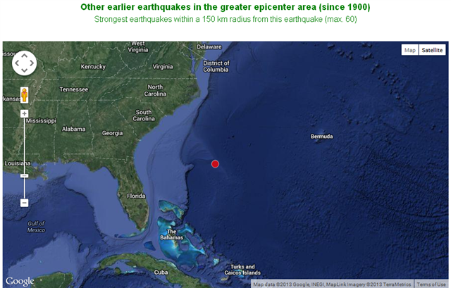
earthquake-report.com...
Other earlier earthquakes in the greater epicenter area (since 1900)
Strongest earthquakes within a 150 km radius from this earthquake
earthquake-report.com...
edit on 7-10-2013 by MariaLida
because: (no reason given)
reply to post by MariaLida
I noticed this one last night and thought it was rather odd. Never in my three years of quake watching have I seen one here.
Why do you think it is a precursor to something bigger? I have the same feeling, but it's just a feeling.
I noticed this one last night and thought it was rather odd. Never in my three years of quake watching have I seen one here.
Why do you think it is a precursor to something bigger? I have the same feeling, but it's just a feeling.
This LINK might be
the reason why a larger earthquake could happen...
Did they omit the South Carolina distances?
557km (346mi) SE of Masonboro, North Carolina
566km (352mi) SE of Wilmington, North Carolina
567km (352mi) SE of Murraysville, North Carolina
653km (406mi) NNE of Nassau, Bahamas
Could the Continental shelf on the East Coast be a cause for concern?
Is this where the Senaca Guns & Booms and the small tidal wave that hit in June in New Jersey are from, movement in the Continental Shelf?
The study links the tsunami to a known Jan. 8, 1817, earthquake. The temblor shook the East Coast from Virginia south to Georgia, where the seismic waves made the State House bell ring several times. Based on archival accounts of the 1817 shaking, geologists had gauged the quake's size at magnitude 4.8 to magnitude 6. Now, with new geologic detective work and computer modeling of the tsunami, researchers have considerably revised the earthquake's size. A magnitude-7.4 quake releases almost 8,000 times more energy than a magnitude-4.8 earthquake.
The foot-high tsunami wave started about 800 miles (1,300 kilometers) south of Delaware Bay and 400 to 500 miles (650 to 800 km) offshore of South Carolina, according to the study, published in the September/October issue of the journal Seismological Research Letters. That's smack on the northwestern limb of the so-called Bermuda Triangle.
Did they omit the South Carolina distances?
557km (346mi) SE of Masonboro, North Carolina
566km (352mi) SE of Wilmington, North Carolina
567km (352mi) SE of Murraysville, North Carolina
653km (406mi) NNE of Nassau, Bahamas
Could the Continental shelf on the East Coast be a cause for concern?
East Coast tsunami risk
However, Hough's goal isn't to solve the mystery of the Bermuda Triangle, but rather to fill in the gaps in the East Coast's earthquake history. Before the new study of the 1817 earthquake, the only other big offshore temblor in recorded history was the 1929 Grand Banks quake, a magnitude-7.2 off the south coast of Newfoundland that unleashed a deadly tsunami.
"Grand Banks has been seen as an outlier or a fluke event," Hough said. "If our interpretation is correct, it points to a more distributed [seismic] hazard. Maybe we should expect this kind of earthquake all along the continental shelf."
Is this where the Senaca Guns & Booms and the small tidal wave that hit in June in New Jersey are from, movement in the Continental Shelf?
edit on 10/8/2013 by whatnext21 because: (no reason given)
There is certainly danger for big quake in Mid-Atlantic Ridge, but not near the Unites States coast, but around Azores - Canary Islands axis. I hope
that one never happens though. Can't imagine what would happen if 8.0+ mag earthquake would hit there. But that strong quake has never happened in
recorded history. Strongest quake on Mid-Atlantic Ridge was 7.3 magnitude, about 39 years ago in 1974, pretty much half-way between Ireland and
Newfoundland.
earthquaketrack.com...
earthquaketrack.com...
reply to post by MariaLida
We had a some stronger seismic activity, but think stronger activity and EQ's still to come soon in this month and time ahead ..
Probably some EQ or EQ's stronger of M 7.4 + somewhere at sensitive areas worldwide
2013-10-12 13:11:54.0 35.56 N 23.31 E 47 6.4 CRETE, GREECE
2013-10-12 02:10:29.0 10.86 N 62.37 W 75 6.0 OFFSHORE SUCRE, VENEZUELA
2013-10-11 23:05:36.0 40.91 N 124.73 W 10 5.0 OFFSHORE NORTHERN CALIFORNIA
2013-10-11 21:24:57.0 30.79 S 178.39 W 132 6.2 KERMADEC ISLANDS, NEW ZEALAND
Also EQ swarm today in S California, Salton sea area..
3.0 15km WSW of Niland, California 2013-10-14 14:39:20 UTC+02:00 0.9 km
3.6 15km WSW of Niland, California 2013-10-14 14:38:23 UTC+02:00 1.5 km
2.7 15km WSW of Niland, California 2013-10-14 14:38:17 UTC+02:00 2.1 km
2.6 16km WSW of Niland, California 2013-10-14 10:39:02 UTC+02:00 1.1 km
2.7 16km W of Niland, California 2013-10-14 10:38:34 UTC+02:00 0.0 km
2.9 15km WSW of Niland, California 2013-10-14 09:16:15 UTC+02:00 2.0 km
2.5 21km ESE of Salton City, California 2013-10-14 09:09:05 UTC+02:00 3.1 km
2.7 11km WSW of Niland, California 2013-10-14 09:07:42 UTC+02:00 6.3 km
3.0 15km WSW of Niland, California 2013-10-14 08:43:34 UTC+02:00 1.3 km
2.5 15km WSW of Niland, California
earthquake.usgs.gov...
edit on 14-10-2013 by MariaLida because: (no reason given)
Creepycrawler
Is that big enough to create a taunami
no , but big enough to create a thread
MariaLida
reply to post by MariaLida
We had a some stronger seismic activity, but think stronger activity and EQ's still to come soon in this month and time ahead ..
Probably some EQ or EQ's stronger of M 7.4 + somewhere at sensitive areas worldwide
2013-10-12 13:11:54.0 35.56 N 23.31 E 47 6.4 CRETE, GREECE
2013-10-12 02:10:29.0 10.86 N 62.37 W 75 6.0 OFFSHORE SUCRE, VENEZUELA
2013-10-11 23:05:36.0 40.91 N 124.73 W 10 5.0 OFFSHORE NORTHERN CALIFORNIA
2013-10-11 21:24:57.0 30.79 S 178.39 W 132 6.2 KERMADEC ISLANDS, NEW ZEALAND
Also EQ swarm today in S California, Salton sea area..
3.0 15km WSW of Niland, California 2013-10-14 14:39:20 UTC+02:00 0.9 km
3.6 15km WSW of Niland, California 2013-10-14 14:38:23 UTC+02:00 1.5 km
2.7 15km WSW of Niland, California 2013-10-14 14:38:17 UTC+02:00 2.1 km
2.6 16km WSW of Niland, California 2013-10-14 10:39:02 UTC+02:00 1.1 km
2.7 16km W of Niland, California 2013-10-14 10:38:34 UTC+02:00 0.0 km
2.9 15km WSW of Niland, California 2013-10-14 09:16:15 UTC+02:00 2.0 km
2.5 21km ESE of Salton City, California 2013-10-14 09:09:05 UTC+02:00 3.1 km
2.7 11km WSW of Niland, California 2013-10-14 09:07:42 UTC+02:00 6.3 km
3.0 15km WSW of Niland, California 2013-10-14 08:43:34 UTC+02:00 1.3 km
2.5 15km WSW of Niland, California
earthquake.usgs.gov...edit on 14-10-2013 by MariaLida because: (no reason given)
: (
We already have have one strong EQ of M 7.2 before some 55 min, preliminary was a M 7.4 ..
EQ of M 7.2 BOHOL, PHILIPPINES
www.abovetopsecret.com...
Thorneblood
reply to post by IandEye
The link you offered doesn't work, so it must be true.
Works fine for me...
Though reads like a bad novel.
anyone know where to find the actual graph for this quake? The one in the OP?
with the govt shut down, i'm having aheck of a time finding a graph anywhere.
has to be one out there on net land, they cant just claim a quake without a station
printing out a squiggly line page for it.
with the govt shut down, i'm having aheck of a time finding a graph anywhere.
has to be one out there on net land, they cant just claim a quake without a station
printing out a squiggly line page for it.
reply to post by MariaLida
One more strong earthquake of M 7.1, also more strong EQ's to come ..
BOUGAINVILLE REGION, P.N.G.
2013-10-16 10:31:01.047min ago 6.54 S 154.91 E 40 7.1 BOUGAINVILLE REGION, P.N.G.
M7.1 - 65km WSW of Panguna, Papua New Guinea 2013-10-16 10:31:01 UTC
6.490°S 154.920°E depth=58.3km (36.2mi)
Nearby Cities
65km (40mi) WSW of Panguna, Papua New Guinea
74km (46mi) WSW of Arawa, Papua New Guinea
377km (234mi) SE of Kokopo, Papua New Guinea
539km (335mi) ESE of Kimbe, Papua New Guinea
642km (399mi) WNW of Honiara, Solomon Islands
earthquake.usgs.gov...
new topics
-
WF Killer Patents & Secret Science Vol. 1 | Free Energy & Anti-Gravity Cover-Ups
General Conspiracies: 1 hours ago -
Hurt my hip; should I go see a Doctor
General Chit Chat: 2 hours ago -
Israel attacking Iran again.
Middle East Issues: 3 hours ago -
Michigan school district cancels lesson on gender identity and pronouns after backlash
Education and Media: 3 hours ago -
When an Angel gets his or her wings
Religion, Faith, And Theology: 4 hours ago -
Comparing the theology of Paul and Hebrews
Religion, Faith, And Theology: 5 hours ago -
Pentagon acknowledges secret UFO project, the Kona Blue program | Vargas Reports
Aliens and UFOs: 5 hours ago -
Boston Dynamics say Farewell to Atlas
Science & Technology: 6 hours ago -
I hate dreaming
Rant: 6 hours ago -
Man sets himself on fire outside Donald Trump trial
Mainstream News: 8 hours ago
top topics
-
The Democrats Take Control the House - Look what happened while you were sleeping
US Political Madness: 9 hours ago, 18 flags -
In an Historic First, In N Out Burger Permanently Closes a Location
Mainstream News: 11 hours ago, 16 flags -
A man of the people
Medical Issues & Conspiracies: 16 hours ago, 11 flags -
Biden says little kids flip him the bird all the time.
Politicians & People: 8 hours ago, 9 flags -
Man sets himself on fire outside Donald Trump trial
Mainstream News: 8 hours ago, 8 flags -
Pentagon acknowledges secret UFO project, the Kona Blue program | Vargas Reports
Aliens and UFOs: 5 hours ago, 6 flags -
Israel attacking Iran again.
Middle East Issues: 3 hours ago, 5 flags -
Michigan school district cancels lesson on gender identity and pronouns after backlash
Education and Media: 3 hours ago, 5 flags -
Boston Dynamics say Farewell to Atlas
Science & Technology: 6 hours ago, 4 flags -
WF Killer Patents & Secret Science Vol. 1 | Free Energy & Anti-Gravity Cover-Ups
General Conspiracies: 1 hours ago, 4 flags
active topics
-
Candidate TRUMP Now Has Crazy Judge JUAN MERCHAN After Him - The Stormy Daniels Hush-Money Case.
Political Conspiracies • 404 • : Zanti Misfit -
When an Angel gets his or her wings
Religion, Faith, And Theology • 4 • : randomuser2034 -
Man sets himself on fire outside Donald Trump trial
Mainstream News • 34 • : WeMustCare -
In an Historic First, In N Out Burger Permanently Closes a Location
Mainstream News • 10 • : Degradation33 -
SC Jack Smith is Using Subterfuge Tricks with Donald Trumps Upcoming Documents Trial.
Dissecting Disinformation • 100 • : WeMustCare -
Israel attacking Iran again.
Middle East Issues • 23 • : KrustyKrab -
So I saw about 30 UFOs in formation last night.
Aliens and UFOs • 37 • : charlyv -
Hurt my hip; should I go see a Doctor
General Chit Chat • 11 • : TheLieWeLive -
Sheetz facing racial discrimination lawsuit for considering criminal history in hiring
Social Issues and Civil Unrest • 7 • : Caver78 -
Silent Moments --In Memory of Beloved Member TDDA
Short Stories • 48 • : Encia22