It looks like you're using an Ad Blocker.
Please white-list or disable AboveTopSecret.com in your ad-blocking tool.
Thank you.
Some features of ATS will be disabled while you continue to use an ad-blocker.

Island emerges near Gwadar coast after earthquake
page: 4share:
A bit of digging will reveal that there is solid rock sand and muddy sediment to the island and something not a lot of people are talking about which
is the fact that there is a lot of methane gas leaking out.
Why is this important that they dont mention this??
Methane is one of the worst greenhouse gases. An earthquake like this could release tons of the stuff and there would be no way to measure or track it. Are the morons charging us a carbon tax going to charge this island or mother nature for this fart?
NASA releases images of Pakistan's 'Earthquake Island'

rt.com...
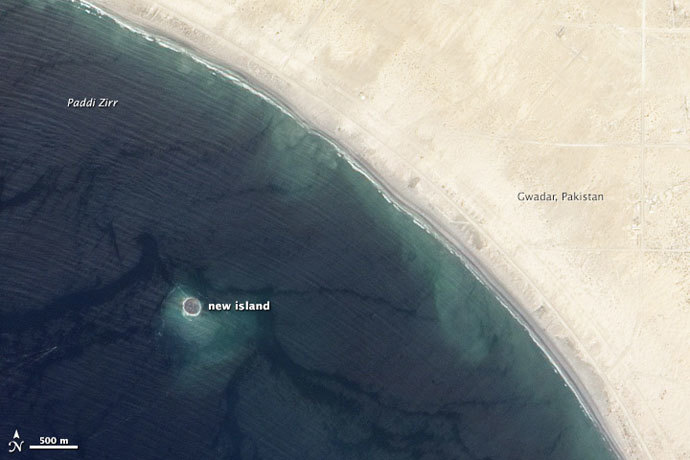
According to scientists, the depth of the water level around Zalzala Jazeera stands at about 15 to 20 meters, stretching 75 to 90 meters across. It lies approximately one mile from the shore. Scientists say the island is nothing more than just a pile of mud, sand and solid rock that was caused by the forces of highly pressurized gas.
The island is really just a big pile of mud from the seafloor that got pushed up. This area of the world seems to see so many of these features because the geology is correct for their formation. You need a shallow, buried layer of pressurized gas—methane, carbon dioxide, or something else—and fluids. When that layer becomes disturbed by seismic waves (like an earthquake), the gases and fluids become buoyant and rush to the surface, bringing the rock and mud with them,” Bill Barnhart, a geologist at the US Geological Survey told NASA’s Earth Observatory.
rt.com...
(post by AdyBasraa removed for a serious terms and conditions violation)
new topics
-
Former Labour minister Frank Field dies aged 81
People: 29 minutes ago -
SETI chief says US has no evidence for alien technology. 'And we never have'
Aliens and UFOs: 2 hours ago -
This is our Story
General Entertainment: 4 hours ago -
President BIDEN Vows to Make Americans Pay More Federal Taxes in 2025 - Political Suicide.
2024 Elections: 7 hours ago -
Ode to Artemis
General Chit Chat: 7 hours ago -
Ditching physical money
History: 11 hours ago -
One Flame Throwing Robot Dog for Christmas Please!
Weaponry: 11 hours ago -
Don't take advantage of people just because it seems easy it will backfire
Rant: 11 hours ago