It looks like you're using an Ad Blocker.
Please white-list or disable AboveTopSecret.com in your ad-blocking tool.
Thank you.
Some features of ATS will be disabled while you continue to use an ad-blocker.

The Day The World Moved : Countries are out of place
page: 3share:
reply to post by iterationzero
Exactly. If France didn't border Germany when the OP was going to school, then all the stuff I learned about WWI must be wrong.
I want the OP to explain that to me. Where was the Maginot Line if it wasn't (partly) on the border of France and Germany (considering the OP says that France and Germany are not supposed to be bordering each other)?
Plus, the people of the Alsace-Lorraine region of France would be very confused if the OP told them that France does not border Germany, considering the region was a disputed part of Germany at the beginning of WWI (Germany annexed that region from France in the Franco-Prussian war in the 1870s), and reverted back to being part of France after Germany lost WWI.
edit on 8/14/2013 by Soylent Green Is People because: (no reason given)
reply to post by AthiestJesus
That might be because new and old countries were formed,reformed and/or dismantled in the last 2 decades.
Does every person on this planet use a photographic memory?
Think hard about that if your trying to work out whats going on with so many thinking countries are in the incorrect place on the map.
and specifically remember Europe being completely different to what it is today ,
That might be because new and old countries were formed,reformed and/or dismantled in the last 2 decades.
but I`d like a conversation on this since I honestly do not know what the hell is going on here and I`m tired of sitting in silence .
Does every person on this planet use a photographic memory?
Think hard about that if your trying to work out whats going on with so many thinking countries are in the incorrect place on the map.
reply to post by AthiestJesus
And guess what?
It still is
Papua New Guinea is about 200km nth of the Cape york, the tip of Australia. To view this from the coast it would look like open sea, you wouldn't be able to see PNG over the horizon
Was this from a world map or map of Australia and surrounding counties?
infact i remember Oz being completely surrounded by open sea .
And guess what?
It still is
Papua New Guinea is about 200km nth of the Cape york, the tip of Australia. To view this from the coast it would look like open sea, you wouldn't be able to see PNG over the horizon
Was this from a world map or map of Australia and surrounding counties?
Originally posted by Soylent Green Is People
Exactly. If France didn't border Germany when the OP was going to school, then all the stuff I learned about WWI must be wrong.
Aye, if Germany and France did not border each other, which country was between them????
However, I agree that Greenland is much smaller that it appears on some maps
Mind, I remember when large parts of what are now France were parts of Britain ....... And Germany and Italy didn't exist.
And as for Belgium .......
And as for Belgium .......
Originally posted by AndyMayhew
...However, I agree that Greenland is much smaller that it appears on some maps
Correct. And (as I'm sure you are aware, but for the sake of people such as the OP) the reason Greenland is so incorrectly large on some maps is easily explainable.
This map below shows Greenland properly, with the 20W latitude through 70W latitude lines converging toward the north pole. This is because the earth is a sphere.
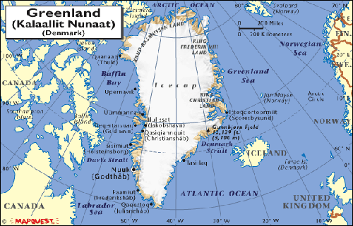
However, some maps flatten out that sphere, and in doing so make the 20W through 70W latitudes lines parallel to each other, which serves to stretch out the top of Greenland, such as in this very inaccurate map:
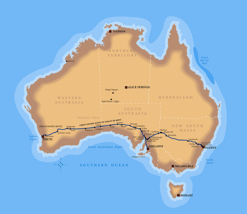
As for the OP's assertions that he remembers maps showing Australia surrounded bu water, there are certainly Australia-centric maps that indicate this, such as the one below, but maps such as this are meant to highlight Australia (the subject of the map) and would not necessarily confuse the issue by including Papua New Guinea
edit on 8/14/2013 by Soylent Green Is People because: (no reason given)
Hi there!
as some people pointed out, maps can be treacherous. All of them are not acurate,because well...they are flat, and Earth is round (yeah, it is!).
That would explain greenland, for example. I do agree: it sometimes seems to be bigger, or far smaller...depends on the map.
But as a French who used to live in Germany,I can assure you that as far as I know, Germany and France have always shared a border.
You mentioned alternate realities. Ok...for the sake of it, let's assume that is the answer. But then, why on earth would you have France, Germany or New Zealand in these alternate realities ?
I mean...France, ok, you NEED France because of the food. No one could ever live without our food, let's be honest.
But Germany...Germany is expendable. Who needs Germany? Apart from Germans, but they are expendables too.
Of course I'm joking: I love Germany, and German people :-) I really do.
No: England is expendable. You should not have England in any alternate reality...
:-)
OP, I do think that your memory, and innacurate maps failed you, that's all.
Cheers!
Here's another statement made by the OP:
Ever since the mid 1800s when the conventions of latitude and longitude were developed, Scotland has always been at the 55th North latitude line, and New York City has always been between the 40th and 41st North latitude line. Therefore, a line drawn directly east from New York City cannot pass through Scotland.
Originally posted by AthiestJesus
...America seems to have moved south and tilted clockwise . I remember if you drew a line directly east from New York you would cross through Scotland...
Ever since the mid 1800s when the conventions of latitude and longitude were developed, Scotland has always been at the 55th North latitude line, and New York City has always been between the 40th and 41st North latitude line. Therefore, a line drawn directly east from New York City cannot pass through Scotland.
reply to post by AthiestJesus
This again? NO just NO. New Zealand is in the correct spot. Remain calm etc etc etc
This again? NO just NO. New Zealand is in the correct spot. Remain calm etc etc etc
reply to post by James1982
This same fecking thread has played out before: www.abovetopsecret.com...
This same fecking thread has played out before: www.abovetopsecret.com...
reply to post by Wookiep
This one? Its really sad if people remember THIS map over a real one. I know New Zealand is not a large or important nation, but we are not a small set of Islands either
This one? Its really sad if people remember THIS map over a real one. I know New Zealand is not a large or important nation, but we are not a small set of Islands either
Originally posted by Noinden
reply to post by AthiestJesus
This again? NO just NO. New Zealand is in the correct spot. Remain calm etc etc etc
Hmmm, on one hand duplicate threads are obviously a waste, but what are people supposed to do? Is there a rule to only post 100% original posts? Unless they are just hours or minutes apart then re-starting threads of similar topics is fine with me, I just don't know why people on here get so pent up about that...
Also this sort of bonkers thread is why I read ATS, I love it. OK - so what if...just what if... (humour me here!) someone did time travel/flip into another almost identical reality, where say France did not border Germany or Australia moved north, whatever, then ATS is the perfect place for them to investigate that...isn't that what ATS is about? There have been some good replies in this thread, I wish more people would embrace the ludicrous a bit more.
Saying all that, OP, you just have a terrible memory mate! Have you not ever owned a globe? I've only recently purchased one, (assuming the globe is correct) it is so much better than looking at distorted maps. whenever I pick it up there's always something I'm surprised about - such as how 'small' India is to what I imagine, considering it will soon be the most populous country.
reply to post by AthiestJesus
Finland is STILL rising up from the sea, so yes,
the country HAS gotten larger
Finland is STILL rising up from the sea, so yes,
the country HAS gotten larger
new topics
-
Bobiverse
Fantasy & Science Fiction: 41 minutes ago -
Florida man's trip overseas ends in shock over $143,000 T-Mobile phone bill
Social Issues and Civil Unrest: 46 minutes ago -
Former Labour minister Frank Field dies aged 81
People: 3 hours ago -
SETI chief says US has no evidence for alien technology. 'And we never have'
Aliens and UFOs: 4 hours ago -
This is our Story
General Entertainment: 7 hours ago -
President BIDEN Vows to Make Americans Pay More Federal Taxes in 2025 - Political Suicide.
2024 Elections: 9 hours ago -
Ode to Artemis
General Chit Chat: 10 hours ago
top topics
-
President BIDEN Vows to Make Americans Pay More Federal Taxes in 2025 - Political Suicide.
2024 Elections: 9 hours ago, 13 flags -
Should Biden Replace Harris With AOC On the 2024 Democrat Ticket?
2024 Elections: 15 hours ago, 6 flags -
One Flame Throwing Robot Dog for Christmas Please!
Weaponry: 14 hours ago, 6 flags -
Don't take advantage of people just because it seems easy it will backfire
Rant: 14 hours ago, 4 flags -
Ditching physical money
History: 13 hours ago, 4 flags -
SETI chief says US has no evidence for alien technology. 'And we never have'
Aliens and UFOs: 4 hours ago, 4 flags -
Ode to Artemis
General Chit Chat: 10 hours ago, 3 flags -
Former Labour minister Frank Field dies aged 81
People: 3 hours ago, 3 flags -
VirginOfGrand says hello
Introductions: 15 hours ago, 2 flags -
This is our Story
General Entertainment: 7 hours ago, 2 flags
active topics
-
President BIDEN Vows to Make Americans Pay More Federal Taxes in 2025 - Political Suicide.
2024 Elections • 35 • : CarlLaFong -
Florida man's trip overseas ends in shock over $143,000 T-Mobile phone bill
Social Issues and Civil Unrest • 1 • : budzprime69 -
Mood Music Part VI
Music • 3094 • : TheWoker -
Don't take advantage of people just because it seems easy it will backfire
Rant • 7 • : confuzedcitizen -
"We're All Hamas" Heard at Columbia University Protests
Social Issues and Civil Unrest • 270 • : TheWoker -
Post A Funny (T&C Friendly) Pic Part IV: The LOL awakens!
General Chit Chat • 7131 • : baddmove -
So this is what Hamas considers 'freedom fighting' ...
War On Terrorism • 250 • : FlyersFan -
Russia Ukraine Update Thread - part 3
World War Three • 5725 • : BernnieJGato -
NASA Researchers Discover a Parallel Universe That Runs Backwards through Time - Alongside Us
Space Exploration • 70 • : seekshelter -
SETI chief says US has no evidence for alien technology. 'And we never have'
Aliens and UFOs • 21 • : network dude