It looks like you're using an Ad Blocker.
Please white-list or disable AboveTopSecret.com in your ad-blocking tool.
Thank you.
Some features of ATS will be disabled while you continue to use an ad-blocker.

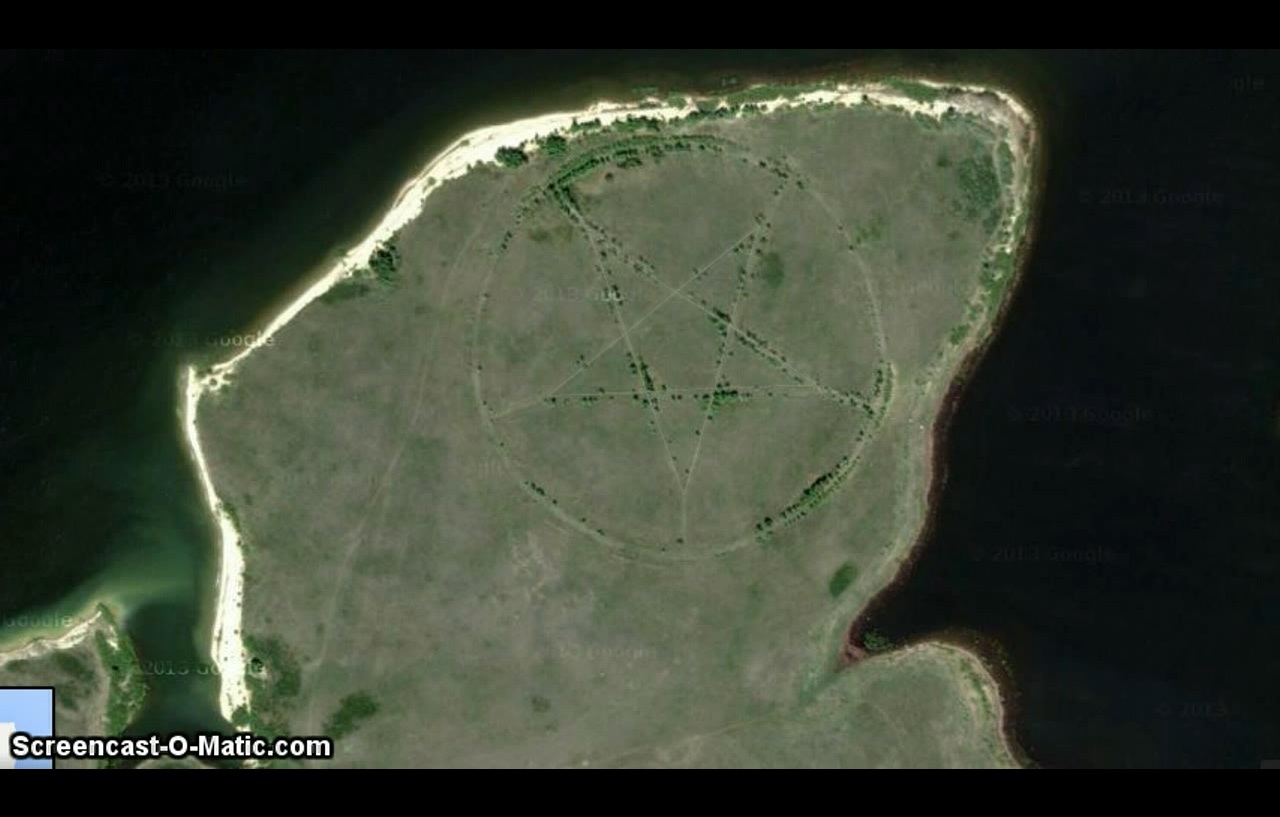
Huge Pentagram in Kazakhstan on Google Maps (VIDEO)
page: 1share:
I've just come across this on wtfrly.com
I've checked the co-ordinates on Google Earth and this pentagram can be clearly seen, apparently it's where the predator class send their children to, a training ground for the so called Illuminati. I dread to think what happens to these kids once inside this devils playground.
Here's the co-ords 52°28’46.65″N 62°11’8.09″E copy and paste into Google Earth.
Link to video
.
Heh, a 400 meter pentagram is kinda
odd, and that's an understatement!
Nice find!
.
Heh, a 400 meter pentagram is kinda
odd, and that's an understatement!
Nice find!
.
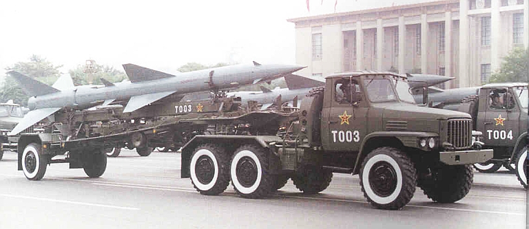
Surface to Air missile installation. That's how the Soviets layed them out.
Proves how evil they were.
Cuba: 23°10'33"N 82°12'52"W
Proves how evil they were.
Cuba: 23°10'33"N 82°12'52"W
Great find. Look like a great place for camping or a Rock Gig.
BTW, have a look at the massive rectangle just south of the pentagram across the estuary next to the water holding thingies...Looks like some sort of underground structure...
BTW, have a look at the massive rectangle just south of the pentagram across the estuary next to the water holding thingies...Looks like some sort of underground structure...
reply to post by Soloprotocol
And the old airfield to the east.
All protected by the SAMs.
And the old airfield to the east.
All protected by the SAMs.
edit on 8/1/2013 by Phage because: (no reason given)
reply to post by Phage
It could be from the Soviet era, strange they used a pentagram layout. I wonder how many more of these places there are.
It could be from the Soviet era, strange they used a pentagram layout. I wonder how many more of these places there are.
reply to post by abdel
It has to do with efficiency of reloading the launchers and the vehicles used to do so.
Here's another configuration
It has to do with efficiency of reloading the launchers and the vehicles used to do so.
Here's another configuration

edit on 8/1/2013 by Phage because: (no reason given)
Originally posted by Phage
reply to post by abdel
It has to do with efficiency of reloading the launchers and the vehicles used to do so.
Here's another configuration
edit on 8/1/2013 by Phage because: (no reason given)
That one looks like Soloman's Seal. This could replace crop circle hunting.
Originally posted by Phage
Surface to Air missile installation. That's how the Soviets layed them out.
Proves how evil they were.
Cuba: 23°10'33"N 82°12'52"W
Could you please provide additional details, or link a thread? Are you saying there are MORE of these pentagrams...I was half wondering was the picture in the OP a hoax.
Please explain.
reply to post by Ameilia
Those are the coordinates to use in Google Earth.
Try this link for Google maps. Turn on the "satellite" option.
grrrrr. another try...
goo.gl...
Those are the coordinates to use in Google Earth.
Try this link for Google maps. Turn on the "satellite" option.
grrrrr. another try...
goo.gl...
edit on 8/1/2013 by Phage because: (no reason given)
reply to post by Phage
Thank you.
So, somehow, these pentagram shapes (which I assume are roads) are supposedly to do with quickly and efficiently loading missiles?
This is just so weird to me, and like everyone else here, I have seen lots of weird stuff. This ranking up there with the best of them.
Thank you.
So, somehow, these pentagram shapes (which I assume are roads) are supposedly to do with quickly and efficiently loading missiles?
This is just so weird to me, and like everyone else here, I have seen lots of weird stuff. This ranking up there with the best of them.
edit
on 8/1/13 by Ameilia because: formatting
reply to post by Ameilia
Or maybe the Soviets really were evil.
Think about how you'd go about maneuvering something like this between five points as efficiently as possible.
So, somehow, these pentagram shapes (which I assume are roads) are supposedly to do with quickly and efficiently loading missiles?
Or maybe the Soviets really were evil.
edit on 8/1/2013 by Phage because: (no reason given)
Near the end of the video it shows it without the sat view. Just the plain map view with labels. It is labeled as "Seal of Devil, Lucifer, and
Adam". Each with a different symbol next to each label. Anyone know what the labels represent??
I don't have Google Maps or Earth.
I don't have Google Maps or Earth.
reply to post by Phage
That image is not loading. Is it one of these you are talking about?
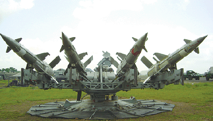
I assume they are much larger in real life than they appear to be in this picture, thus the roads being shaped as they are?
That image is not loading. Is it one of these you are talking about?
I assume they are much larger in real life than they appear to be in this picture, thus the roads being shaped as they are?
reply to post by Phage
Thanks for helping me understand this better Phage. I truly appreciate you taking the time to explain things to nearly everyone who asks you to on this board.
Thanks for helping me understand this better Phage. I truly appreciate you taking the time to explain things to nearly everyone who asks you to on this board.
Originally posted by mOjOm
Near the end of the video it shows it without the sat view. Just the plain map view with labels. It is labeled as "Seal of Devil, Lucifer, and Adam". Each with a different symbol next to each label. Anyone know what the labels represent??
I don't have Google Maps or Earth.
Not trying to rain on the whole "Phage is Great" tribute thing going on here, but I was just wondering if anyone found out anything about the Landmarks which I mentioned above???
new topics
-
Supreme Court Oral Arguments Today 4.25.2024 - Are PRESIDENTS IMMUNE From Later Being Prosecuted.
Above Politics: 4 minutes ago -
Krystalnacht on today's most elite Universities?
Social Issues and Civil Unrest: 13 minutes ago -
Chris Christie Wishes Death Upon Trump and Ramaswamy
Politicians & People: 40 minutes ago -
University of Texas Instantly Shuts Down Anti Israel Protests
Education and Media: 2 hours ago -
Any one suspicious of fever promotions events, major investor Goldman Sachs card only.
The Gray Area: 4 hours ago -
God's Righteousness is Greater than Our Wrath
Religion, Faith, And Theology: 9 hours ago
top topics
-
VP's Secret Service agent brawls with other agents at Andrews
Mainstream News: 13 hours ago, 10 flags -
Cats Used as Live Bait to Train Ferocious Pitbulls in Illegal NYC Dogfighting
Social Issues and Civil Unrest: 17 hours ago, 8 flags -
Nearly 70% Of Americans Want Talks To End War In Ukraine
Political Issues: 14 hours ago, 5 flags -
Sunak spinning the sickness figures
Other Current Events: 14 hours ago, 5 flags -
Electrical tricks for saving money
Education and Media: 12 hours ago, 4 flags -
Late Night with the Devil - a really good unusual modern horror film.
Movies: 16 hours ago, 3 flags -
Krystalnacht on today's most elite Universities?
Social Issues and Civil Unrest: 13 minutes ago, 2 flags -
Any one suspicious of fever promotions events, major investor Goldman Sachs card only.
The Gray Area: 4 hours ago, 2 flags -
University of Texas Instantly Shuts Down Anti Israel Protests
Education and Media: 2 hours ago, 2 flags -
Chris Christie Wishes Death Upon Trump and Ramaswamy
Politicians & People: 40 minutes ago, 0 flags
active topics
-
Nearly 70% Of Americans Want Talks To End War In Ukraine
Political Issues • 62 • : Consvoli -
"We're All Hamas" Heard at Columbia University Protests
Social Issues and Civil Unrest • 281 • : marg6043 -
University of Texas Instantly Shuts Down Anti Israel Protests
Education and Media • 31 • : FlyersFan -
I Guess Cloud Seeding Works
Fragile Earth • 42 • : WaESN -
Supreme Court Oral Arguments Today 4.25.2024 - Are PRESIDENTS IMMUNE From Later Being Prosecuted.
Above Politics • 0 • : WeMustCare -
D.C. Court of Appeals made a horrible ruling against Trump
US Political Madness • 320 • : WeMustCare -
Krystalnacht on today's most elite Universities?
Social Issues and Civil Unrest • 1 • : FlyersFan -
New whistleblower Jason Sands speaks on Twitter Spaces last night.
Aliens and UFOs • 58 • : Ophiuchus1 -
SETI chief says US has no evidence for alien technology. 'And we never have'
Aliens and UFOs • 63 • : andy06shake -
Chris Christie Wishes Death Upon Trump and Ramaswamy
Politicians & People • 3 • : ImagoDei