It looks like you're using an Ad Blocker.
Please white-list or disable AboveTopSecret.com in your ad-blocking tool.
Thank you.
Some features of ATS will be disabled while you continue to use an ad-blocker.

Where are the aliens supposed to live within Tycho crater on the Moon ?
page: 2share:

reply to post by qmantoo
I've already emaild LRO Team, one year ago, when I stumbled upon that thread of Tycho and after my own research in LRO... and find "nothing": ONLY a Black AREA.
I'm still waiting their answer on WHY, exactly that AREA inside Tycho (THE CENTRAL PEAK) was, NOT IMAGED.
Maybe Today.... or Tomorrow... I will recieve their answer...? I'm confident....
Yes, it is suspicious that the Quickmap does not have this area imaged yet, but you could always ask the LRO team when they intend to fill in the gaps to Tycho crater and see what the answer is. Also, there may be other less pixellated images out there.
I've already emaild LRO Team, one year ago, when I stumbled upon that thread of Tycho and after my own research in LRO... and find "nothing": ONLY a Black AREA.
I'm still waiting their answer on WHY, exactly that AREA inside Tycho (THE CENTRAL PEAK) was, NOT IMAGED.
Maybe Today.... or Tomorrow... I will recieve their answer...? I'm confident....
Originally posted by Unity_99
The entire inner moon is a network of tubes and bases. Its not just crater.
I'm pretty sure you're thinking of the internet.
Originally posted by raifordko
reply to post by Arken
WHen you go to 100 feet of that area on the quickmap, it looks like rocks. Your image is from 3000 meters.
hi there.
Please provide and share the image of that particular (specific) Area (Lat/Long. Min. Sec.) inside Tycho and on that side of the central peak, of the QuickMap database.
Thanks in advance.
Originally posted by Arken
Originally posted by Soylent Green Is People
Originally posted by Arken
reply to post by Soylent Green Is People
Hi there, Soylent.
Maybe the other images in that "old" thread I've posted are more intriguing.
The shadow and light "game", three circular structures inside the "base", and the parallel tubes seems absolutely unnatural.
When I zoom in on those coordinates, I don't see the same thing you are showing (maybe I'm doing something wrong?)
Did you use the "QuickMap" shown in the OP, and zoom to the highest resolution possible?
No I use the Jaxa/Kaguya image in Google Moon.
You can't see nothing in the "QuickMap" or "LRO" because exactly that AREA is NOT IMAGED.
Don't you think it is quite souspicious?
Jaxa/Kaguya images what resolution are those at before you zooomed in to much as usual.
The TC terrain camera is 10mtr / Pixel the LRO 0.5mtr/pixel many times the resolution of Jaxa/Kaguya it will pass over that area take a picture and you will see you are wrong!
reply to post by Arken
On the Go To put in -43.31 Latitude and -11.36 Longitude, I am not sure why you would say the area is not imaged, it is almost fully imaged.
Now if you put in 43.31 and 11.36 you are in North and East which is wrong, you want to use South and West which are both - numbers. The North and East Lat/Lon seem to be an un-imaged area, but it is an area of no consequence.
In fact, it is so clear that you can see your actual photo's "buildings" which appear to be a good amount of large rock debris and rock outcroppings. Many people have also always tried to say that Tycho has a pyramid in the middle of it, but it definitely seems to be a massive rock rebound (Or if you are into EU theory there are other explanations for it)
edit on 17-7-2013 by raifordko because: (no reason given)
Originally posted by qmantoo
Tycho
Center Longitude: 348.784650841294990
Center Latitude: -43.295805949147599
(roughly 43.31S, 11.36W)
I ask because the images contained within the Quickmap website taken by the LRO are awesome and would surely give some indication of alien habitation if there were supposed to be cities and other structures on the surface.
Unless the whole thing is generated by some super-duper game background software, I think there should be evidence of aliens if they are there, dont you?
I think some people are confused by how Longitude and Latitude works btw. You should update your original post to include the numerical values which are (Latitude -43.31, Longitude -11.36)
North and East Lon/Lat's are characterized with positive numbers, South and West Lat/Lon are characterized with negative numbers.
if people are ending up in an un-imaged area, they are not at Tycho Crater as Tycho crater is fully mapped.
reply to post by qmantoo
I am actually having trouble locating the equipment at every landing site. Considering I have worked in sky-rise buildings my entire career, almost, I know what I should and should not be able to see at 100 feet. In NYC I worked on the 18th floor and I could see tire tracks in the snow. So at 200 feet tire tracks were quite obvious. I would think that they should be more obvious at 100 feet, and since I could see a hot dog stand operators mustache I think I would be able to see a flag...
I'm using this site for the lat/lon:
airandspace.si.edu...
Edit: I mean when I zoom out I see what I think should be the sites and what I think is equipment (Say zoom out to 1000 to 200 feet) but when I zoom into 100 feet I don't see anything, but I am convinced it is because my eyes are looking at an alien landscape that I am not familiar with.
edit on 17-7-2013 by raifordko because: (no reason given)
"Where are the aliens supposed to live within Tycho crater on the Moon ?"
In their Alien houses of coarse.
Would they have certain classes of society and different housing to suite.
Would the poor and unfortunate aliens live near the bottom of the crater, in the ghetto in commission housing and the better of would have beautiful views in their alien mansions along the craters edge?
Lets pray these aliens arent lactose intolerant as living on a moon made of cheese would create one hell of a stink
Originally posted by raifordko
reply to post by qmantoo
I am actually having trouble locating the equipment at every landing site. Considering I have worked in sky-rise buildings my entire career, almost, I know what I should and should not be able to see at 100 feet.
YOU don't see anything at 100ft the LRO was in orbit first at 50 km then the orbits were lowered down to 21km for a higher resolution.
Were do you get the 100ft number from if its on a zoomed in picture its a scale along the ground not the altitude you are viewing from!!!
reply to post by wmd_2008
I know, it zooms in to an elevation of 100 ft with a 0.5m per pixel ratio. At that ratio I should be able to see tracks and equipment without issue, although semi blurry. Just to be clear, I am not saying they aren't there, I fully believe we landed on the moon, I am saying I am not experienced enough to find them.
Edit: And just so you know, that is almost the same quality as Google satellite view when you use maps.google.com, so it is a pretty good indicator of how the quality should be on an imaged area. (Google is generally 1.3 fpp)
I also don't see the point of your post. Obviously I was talking about the zoomed in elevation. Is there something you aren't understanding? We know the zoomed in elevation and the meters per pixel for that zoom. With that we can determine that these should be fairly good images of what the ground would look like if you were in a 10 story building on the moon albeit with less than 20/20 vision.
edit on 17-7-2013 by raifordko because: (no
reason given)
Originally posted by raifordko
reply to post by wmd_2008
I know, it zooms in to an elevation of 100 ft with a 0.5m per pixel ratio. At that ratio I should be able to see tracks and equipment without issue, although semi blurry. Just to be clear, I am not saying they aren't there, I fully believe we landed on the moon, I am saying I am not experienced enough to find them.
Edit: And just so you know, that is almost the same quality as Google satellite view when you use maps.google.com, so it is a pretty good indicator of how the quality should be on an imaged area. (Google is generally 1.3 fpp)
I also don't see the point of your post. Obviously I was talking about the zoomed in elevation. Is there something you aren't understanding? We know the zoomed in elevation and the meters per pixel for that zoom. With that we can determine that these should be fairly good images of what the ground would look like if you were in a 10 story building on the moon albeit with less than 20/20 vision.edit on 17-7-2013 by raifordko because: (no reason given)
THE LRO pictures do not give an indication of elevation it's not like Google Earth the scale is a distance along the surface not the height being viewed from is that not simple enough to understand
Here is an LRO image of the Apollo 17 site
The 100mtrs at the TOP Right of the image is not there to show 100 mtr elevation it's to show 100 mtrs along the surface NOW do you get it!!!
edit on 17-7-2013 by wmd_2008 because: (no reason given)
edit on 17-7-2013 by wmd_2008 because: (no reason given)
reply to post by wmd_2008
Ahh I see. Yes, I should not have said elevation. I did indeed mean the scale in that x amount of space = 100 ft. And I did intentionally mean to compare it to maps.google.com because that is also .5m per pixel. However, your explanation has now clicked in my head and I realize that I am actually viewing it from much farther away that I previously thought.
I said several times I am not familiar with this so I do appreciate the explanation, whether exceedingly douchey or not.
Originally posted by raifordko
reply to post by wmd_2008
Ahh I see. Yes, I should not have said elevation. I did indeed mean the scale in that x amount of space = 100 ft. And I did intentionally mean to compare it to maps.google.com because that is also .5m per pixel. However, your explanation has now clicked in my head and I realize that I am actually viewing it from much farther away that I previously thought.
I said several times I am not familiar with this so I do appreciate the explanation, whether exceedingly douchey or not.
No comment on the picture I see how d_________y of you!!!
reply to post by wmd_2008
Why would I need to comment on the picture? You seem to be implying I was denying the equipment was there, when that wasn't the case. I was saying I wasn't knowledgeable enough of moon maps to know how or what to look for. I wanted to know how to find them in the quickmap using the lat/lon that I posted previously.
Why would I need to comment on the picture? You seem to be implying I was denying the equipment was there, when that wasn't the case. I was saying I wasn't knowledgeable enough of moon maps to know how or what to look for. I wanted to know how to find them in the quickmap using the lat/lon that I posted previously.
In Quickmaps there IS an elevation as well as a scale isn't there? The highest zoom level is 100ft on most of the areas of Tycho crater and also I
have looked at AS15 site and it is the same.
This is the Easterly longitude given by Quickmap when you click on the 'spot' identifying Tycho crater on the map. I just copied and pasted it. Yes, I could have given longitude relative to +180 -180 but since I gave the Quickmap link, it is better to go with that. Other maps use the other ways of expressing longitudes but they all should resolve to the same place. Not my problem but the problem is that science cannot decide how to express longitudes in a standard way. It is just like humans work in degrees, minutes and seconds but it is easier for computers to work in decimal degrees.
I think some people are confused by how Longitude and Latitude works btw. You should update your original post to include the numerical values which are (Latitude -43.31, Longitude -11.36)
North and East Lon/Lat's are characterized with positive numbers, South and West Lat/Lon are characterized with negative numbers.
Originally posted by qmantoo
In Quickmaps there IS an elevation as well as a scale isn't there? The highest zoom level is 100ft on most of the areas of Tycho crater and also I have looked at AS15 site and it is the same.
WRONG here is an image of Tycho from the Lro quick map
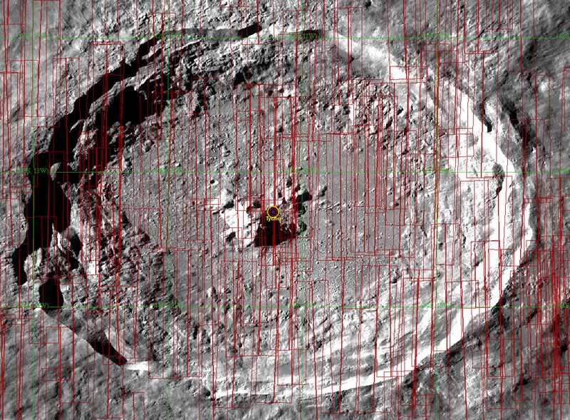
Each red rectangle is an area imaged by the LRO the scale on the pictures is the DISTANCE on the surface ( not an approx altitude) like the scale on any map!
As you can see this crater has many hi-res images to 0.5 mtrs/pixel.
Here is a rock on the top of the central peak
Close Up
edit on 17-7-2013 by wmd_2008 because: (no reason given)
edit on 17-7-2013 by wmd_2008 because: (no reason given)
Originally posted by raifordko
reply to post by wmd_2008
Why would I need to comment on the picture? You seem to be implying I was denying the equipment was there, when that wasn't the case. I was saying I wasn't knowledgeable enough of moon maps to know how or what to look for. I wanted to know how to find them in the quickmap using the lat/lon that I posted previously.
Well YOU said you couldn't see the equipment on the images so I showed an image showing the equipment so I thought you would have made a comment.
reply to post by wmd_2008
Maybe if you gave me an image on the quickmap I would have said something. I want to use the quickmap with friends and I was hoping I could go to the specific coordinates and see the equipment using the quickmap.
Maybe if you gave me an image on the quickmap I would have said something. I want to use the quickmap with friends and I was hoping I could go to the specific coordinates and see the equipment using the quickmap.
Originally posted by raifordko
reply to post by wmd_2008
Maybe if you gave me an image on the quickmap I would have said something. I want to use the quickmap with friends and I was hoping I could go to the specific coordinates and see the equipment using the quickmap.
Here you go Apollo 11
Apollo 11
new topics
-
whistleblower Captain Bill Uhouse on the Kingman UFO recovery
Aliens and UFOs: 4 hours ago -
1980s Arcade
General Chit Chat: 6 hours ago -
Deadpool and Wolverine
Movies: 7 hours ago -
Teenager makes chess history becoming the youngest challenger for the world championship crown
Other Current Events: 8 hours ago -
CIA botched its handling of sexual assault allegations, House intel report says
Breaking Alternative News: 9 hours ago
top topics
-
Lawsuit Seeks to ‘Ban the Jab’ in Florida
Diseases and Pandemics: 12 hours ago, 20 flags -
Starburst galaxy M82 - Webb Vs Hubble
Space Exploration: 14 hours ago, 13 flags -
The Superstition of Full Moons Filling Hospitals Turns Out To Be True!
Medical Issues & Conspiracies: 15 hours ago, 8 flags -
CIA botched its handling of sexual assault allegations, House intel report says
Breaking Alternative News: 9 hours ago, 8 flags -
15 Unhealthiest Sodas On The Market
Health & Wellness: 14 hours ago, 6 flags -
whistleblower Captain Bill Uhouse on the Kingman UFO recovery
Aliens and UFOs: 4 hours ago, 6 flags -
1980s Arcade
General Chit Chat: 6 hours ago, 4 flags -
Teenager makes chess history becoming the youngest challenger for the world championship crown
Other Current Events: 8 hours ago, 3 flags -
Deadpool and Wolverine
Movies: 7 hours ago, 3 flags
active topics
-
Definitive 9.11 Pentagon EVIDENCE.
9/11 Conspiracies • 420 • : Lazy88 -
1980s Arcade
General Chit Chat • 8 • : F2d5thCavv2 -
What is a dream
The Gray Area • 27 • : wrayth -
Europe declares war on Russia?
World War Three • 61 • : F2d5thCavv2 -
The Acronym Game .. Pt.3
General Chit Chat • 7741 • : F2d5thCavv2 -
Russia Ukraine Update Thread - part 3
World War Three • 5713 • : F2d5thCavv2 -
IDF Intel Chief Resigns Over Hamas attack
Middle East Issues • 32 • : Terpene -
15 Unhealthiest Sodas On The Market
Health & Wellness • 32 • : VariedcodeSole -
Fast Moving Disc Shaped UFO Captured on Camera During Flight from Florida to New York City
Aliens and UFOs • 18 • : inflaymes69 -
They Killed Dr. Who for Good
Rant • 61 • : Cymru