It looks like you're using an Ad Blocker.
Please white-list or disable AboveTopSecret.com in your ad-blocking tool.
Thank you.
Some features of ATS will be disabled while you continue to use an ad-blocker.

Strange south-to-north weather pattern over U.S. source of flooding and wildfires
page: 111
share:
I was watching the weather this evening and I was struck in awe by a huge storm system which is traveling in a south-to-north pattern over the United
States. I've always known storm systems to run west-to-east, so I decided to do a bit of research. I luckily came across this weather blog which I
think helps explain the current weather phenomena.
Strange Weather in U.S.
The writer goes on to say that this extreme weather pattern is the source of major flooding in the southeast, wildfires and extreme heat in the southwest, and hailstorms in New Mexico. The writer also points to global warming as a potential source of the current weather phenomenon.
So, what do you guys think about the strange weather? Is it global warming, nature, HAARP?
Strange Weather in U.S.
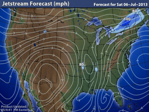
An extreme weather pattern for parts of the U.S. is expected to continue to stick around for the next several days. There is a large upper level trough of low pressure stalled across the central U.S., and two areas of high pressure – one in the U.S. West and another across Bermuda – have been holding in place for the past several days. With no movement, this large trough has been unable to push out of the country, and this blocking pattern has brought tropical moisture streaming into the U.S. Southeast and major heat across the U.S. Southwest.
The writer goes on to say that this extreme weather pattern is the source of major flooding in the southeast, wildfires and extreme heat in the southwest, and hailstorms in New Mexico. The writer also points to global warming as a potential source of the current weather phenomenon.
Can we link climate change with the current unusual weather pattern? According to a report released on October 2012 by the National Oceanic and Atmospheric Administration (NOAA), the warming of the Arctic and the overall planet can influence the orientation of the jet stream. According to the report: The effects of Arctic amplification will increase as more summer ice retreats over coming decades. Enhanced warming of the Arctic affects the jet stream by slowing its west-to-east winds and by promoting larger north-south meanders in the flow. Predicting those meanders and where the weather associated with them will be located in any given year, however, remains a challenge. The current weather occurring across North America is an example of what climate change can do to our jet stream over time.
So, what do you guys think about the strange weather? Is it global warming, nature, HAARP?
It's totally abnormal. This hasn't happened in, like, a year!
In all seriousness, we are seeing the rain, and yes, it is moving south to north. We usually have at least one of these types of patterns a year. It will rain like crazy, with hot, humid air, and then it will be nice and sunny again while everything dries up.
Incidentally, it has rained on and off the last several years on the Fourth of July. It would be unusual if this system were not occurring in that respect.
It's just called "weather." Scientists looking to fit it to an agenda notwithstanding,
TheRedneck
I have to go with the Redneck on this one. I live in Southside Virginia and while this is not a normal occurrence, it is not super rare either. Our
biggest snows always come from South to North as I live just beyond the Blue Ridge Mountains. If the system comes in from the side, the mountains
shred it before we see the full force of it.
It has rained so much here the last few days, I could almost pull a water skier behind my lawnmower this evening. Really. Had it been snow??? We would have been in more trouble.
I would say that so far this year, it is not really out of what we here call normal. It's early days yet though.
It has rained so much here the last few days, I could almost pull a water skier behind my lawnmower this evening. Really. Had it been snow??? We would have been in more trouble.
I would say that so far this year, it is not really out of what we here call normal. It's early days yet though.
It was nice to have a bit of cloud cover in the northwest today with some brief gusts of wind but I was praying hard it wouldn't rain (getting my
roof torn off). I think its way hotter this July. We hit 105 the other day and where I live 80 is hot (and the norm). It can get into the 90's a few
days but 105 is a bit extreme.
I did notice a stillness in the clouds - stagnant and feel it in the air right now. I thought one large lone cloud was a puff of smoke as it was sitting really close to the ground. I think its climate change (whether normal cycle, man made, or a bit of both).
I did notice a stillness in the clouds - stagnant and feel it in the air right now. I thought one large lone cloud was a puff of smoke as it was sitting really close to the ground. I think its climate change (whether normal cycle, man made, or a bit of both).
reply to post by BattleStarGal
thats true! Very Extreme Weather worldwide..Very Strange!
www.abovetopsecret.com...&addstar=1&on=16620253#pid16620253
thats true! Very Extreme Weather worldwide..Very Strange!
www.abovetopsecret.com...&addstar=1&on=16620253#pid16620253
It's the same as has been happening for several years - the same reason for the Russian heatwave of 2010 and for the cold winters in Europe, and
recent heatwaves in the US. The jet stream is weak and therefore meandering a lot more than usual. This in turn is likely to be, at least in part,
due to recent Arctic warming (the greater the temp gradient between tropics and pole, the stronger the jet - if the Arctic warms faster than the
tropics, as has been happening, then the gradient diminishes and the jet weakens. Like a river, a slow moving jet meanders more than a fast one.
This means more meridional (north-south or south-north) weather patterns instead of the zonal (west-east) ones we have been used to)
edit on
5-7-2013 by AndyMayhew because: (no reason given)
reply to post by cheesy
cheesy! wtf, yo!..
you can't be linking people to the stars on your thread!!!!!!
LOL!
Originally posted by cheesy
thats true! Very Extreme Weather worldwide..Very Strange!
www.abovetopsecret.com...&addstar=1&on=16620253#pid16620253
cheesy! wtf, yo!..
you can't be linking people to the stars on your thread!!!!!!
LOL!
edit on 5-7-2013 by iunlimited491 because: (no reason given)
reply to post by cheesy
I'm glad I'm not the only one who noticed the strange weather Cheesy.
According to others, this storm system isn't anything out of the ordinary, but it still freaks me out a bit.
I'm glad I'm not the only one who noticed the strange weather Cheesy.
According to others, this storm system isn't anything out of the ordinary, but it still freaks me out a bit.
Current Radar:
(07/05/13) 3:00pm EST
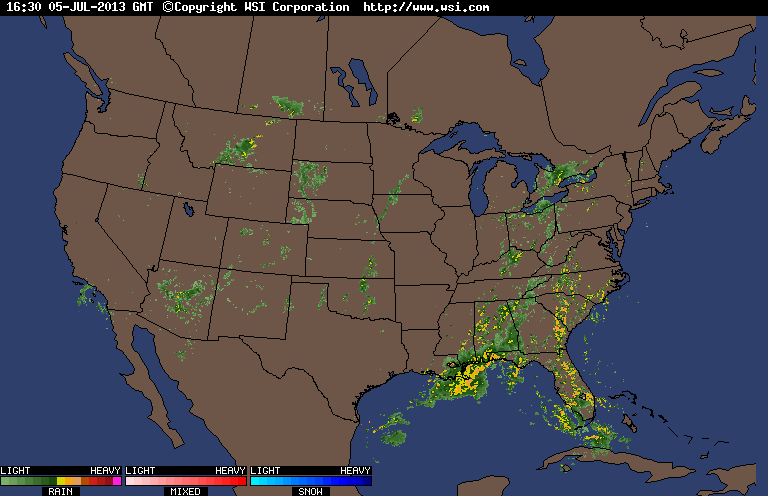
www.intellicast.com...
As temperatures increase throughout the day;
during the peak heating period, more storms begin to form.
__
This system also continues to cause substantial flooding in the southern U.S..
In some places they're reporting up to 18" of rain within just the past few days.
(07/05/13) 3:00pm EST
www.intellicast.com...
As temperatures increase throughout the day;
during the peak heating period, more storms begin to form.
__
This system also continues to cause substantial flooding in the southern U.S..
In some places they're reporting up to 18" of rain within just the past few days.
edit on 5-7-2013 by iunlimited491 because: (no reason
given)
I will update this thread again because it is already discussing the topic.
(07/05/13) 7:00pm EST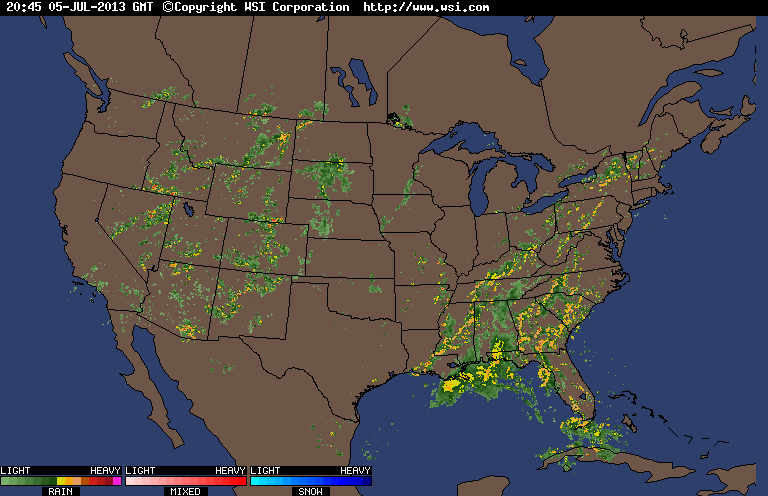
www.intellicast.com...
^This radar-loop does a good job of showing exactly what the problem is.
For those who don't understand: The system in the east is stalled out because it is being blocked by the high pressure in the Atlantic. Instead of continuing out of the country when it reached the coast, it became stuck. - Now it is trying to work it's way North, around the high-pressure system while continuing to feed off of tropical moisture from the south.
The dry storms in the west are being pushed downward by the low pressure and are caught in another high pressure system. Causing them to be stuck in one place as well.
edit on 5-7-2013 by iunlimited491 because: (no reason given)
reply to post by BattleStarGal
I'm one of those people who believe the weather is growing stranger all over the world -- so of course, this thread would get a S&F from me.
I'm one of those people who believe the weather is growing stranger all over the world -- so of course, this thread would get a S&F from me.
I live in the Deep South and every storm that passes by me ends up passing through DC eventually. That means South to North.
reply to post by BattleStarGal
Is nothing strange on this pattern at all, the moisture always comes from the south to the north, that is how hurricane comes into land during the hurricane season.
Moisture from the gulf is what keeps the south weather wet.
I guess people have short memories, we are just getting out of a dry spell, but when I moved here in the south back in the 90s it was nothing but floods and rain, 94 flood, 98 flood and the last one early in the 2000s, then we got a dry spell that lasted a few seasons.
Now we are back to wet and humid again, nothing new.
I took this picture from Renssalaer County, NY - in the Capital Region, on Friday 07/05/13
This system was responsible for several Tornado Warnings further west - in Central, NY
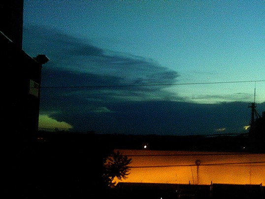
This doesn't show the lightening in the storm, but it was an awesome thing to see.
This system was responsible for several Tornado Warnings further west - in Central, NY
This doesn't show the lightening in the storm, but it was an awesome thing to see.
edit on 7-7-2013 by iunlimited491 because: (no reason given)
new topics
-
Weinstein's conviction overturned
Mainstream News: 3 minutes ago -
Supreme Court Oral Arguments 4.25.2024 - Are PRESIDENTS IMMUNE From Later Being Prosecuted.
Above Politics: 1 hours ago -
Krystalnacht on today's most elite Universities?
Social Issues and Civil Unrest: 1 hours ago -
Chris Christie Wishes Death Upon Trump and Ramaswamy
Politicians & People: 2 hours ago -
University of Texas Instantly Shuts Down Anti Israel Protests
Education and Media: 4 hours ago -
Any one suspicious of fever promotions events, major investor Goldman Sachs card only.
The Gray Area: 6 hours ago -
God's Righteousness is Greater than Our Wrath
Religion, Faith, And Theology: 10 hours ago
top topics
-
VP's Secret Service agent brawls with other agents at Andrews
Mainstream News: 15 hours ago, 11 flags -
Nearly 70% Of Americans Want Talks To End War In Ukraine
Political Issues: 16 hours ago, 6 flags -
Sunak spinning the sickness figures
Other Current Events: 16 hours ago, 5 flags -
Electrical tricks for saving money
Education and Media: 14 hours ago, 4 flags -
Supreme Court Oral Arguments 4.25.2024 - Are PRESIDENTS IMMUNE From Later Being Prosecuted.
Above Politics: 1 hours ago, 4 flags -
Krystalnacht on today's most elite Universities?
Social Issues and Civil Unrest: 1 hours ago, 4 flags -
University of Texas Instantly Shuts Down Anti Israel Protests
Education and Media: 4 hours ago, 2 flags -
Any one suspicious of fever promotions events, major investor Goldman Sachs card only.
The Gray Area: 6 hours ago, 2 flags -
Weinstein's conviction overturned
Mainstream News: 3 minutes ago, 2 flags -
Chris Christie Wishes Death Upon Trump and Ramaswamy
Politicians & People: 2 hours ago, 1 flags
active topics
-
Weinstein's conviction overturned
Mainstream News • 4 • : marg6043 -
Chris Christie Wishes Death Upon Trump and Ramaswamy
Politicians & People • 7 • : underpass61 -
University of Texas Instantly Shuts Down Anti Israel Protests
Education and Media • 93 • : marg6043 -
Supreme Court Oral Arguments 4.25.2024 - Are PRESIDENTS IMMUNE From Later Being Prosecuted.
Above Politics • 6 • : TzarChasm -
President BIDEN Vows to Make Americans Pay More Federal Taxes in 2025 - Political Suicide.
2024 Elections • 143 • : SchrodingersRat -
SETI chief says US has no evidence for alien technology. 'And we never have'
Aliens and UFOs • 65 • : andy06shake -
Sunak spinning the sickness figures
Other Current Events • 18 • : andy06shake -
British TV Presenter Refuses To Use Guest's Preferred Pronouns
Education and Media • 155 • : Annee -
Nearly 70% Of Americans Want Talks To End War In Ukraine
Political Issues • 76 • : FlyersFan -
The Reality of the Laser
Military Projects • 49 • : 5thHead
11