It looks like you're using an Ad Blocker.
Please white-list or disable AboveTopSecret.com in your ad-blocking tool.
Thank you.
Some features of ATS will be disabled while you continue to use an ad-blocker.

The Mystery of the Fool’s Cap Map of the World
page: 1share:
Many have seen this map before, many may have not. I for one have always found it a mixture of curiosity, intrigue and a beautiful art form. Just
thought I'd post this and ask the question: What does it mean to you?
I know that "All the World's a Stage" comes to mind for me and also: "It's a Mad, Mad, Mad World"" Or maybe "We all Wear Masks." or "Our Reality is but an illusion" OR.....?????
Whatever it was meant to be, it has stumped many more intelligent people than I for hundreds of years. Some say Evil...some say Christian...(The argument of same could be made as well).
I have also often wondered if there is an actual person wearing the mask to be painted. Was it a mask that could even be modeled? And if so, was it worn by an apprentice to the cartographer? A friend? An Elite? A Lover?
And also, since no one really knows who, when, where etc...is it even a cartographer? Perhaps it could be a one-off by an artist of the time?
So many questions...Damn Mysteries
bigthink.com...
For those interested in seeing a more detailed image: cartanciennes.free.fr...
Just click to enlarge of course.
And one last mystery to add.
Of course the ideas and opinions presented by the author are also just that. Thoughts and personal conclusions based on the little info available.
One thing I did find interesting tho is this:
"The map is very modern in appearance, yet it dates back to about 1580-1590. Although Epichtonius Cosmopolites appears to be the artist’s name, it translates roughly as “Everyman,” leaving the true identity of the mapmaker a mystery."
Damn Mysteries...
Peace
I know that "All the World's a Stage" comes to mind for me and also: "It's a Mad, Mad, Mad World"" Or maybe "We all Wear Masks." or "Our Reality is but an illusion" OR.....?????
Whatever it was meant to be, it has stumped many more intelligent people than I for hundreds of years. Some say Evil...some say Christian...(The argument of same could be made as well).
I have also often wondered if there is an actual person wearing the mask to be painted. Was it a mask that could even be modeled? And if so, was it worn by an apprentice to the cartographer? A friend? An Elite? A Lover?
And also, since no one really knows who, when, where etc...is it even a cartographer? Perhaps it could be a one-off by an artist of the time?
So many questions...Damn Mysteries
bigthink.com...
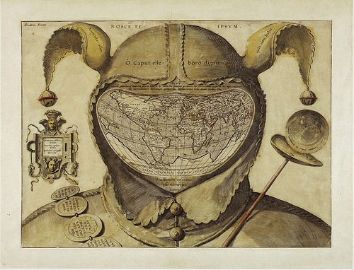
Most often referred to simply as the Fool’s Cap Map of the World, it is unknown why, when, where and by whom it was made.
The only thing that can be said about it with some certainty is that it dates from ca. 1580-1590. But sources even differ as to the type of projection used, some referring to it as ptolemaic (i.e. equidistant conic), others claiming it owes more to the techniques of Mercator and/or Ortelius (and being an enthusiast rather than a specialist, I’m not one to call this).
For those interested in seeing a more detailed image: cartanciennes.free.fr...
Just click to enlarge of course.
The uncomfortable truth told by this map is that the world is a sombre, irrational and dangerous place, and that life on it is nasty, brutish and short. The world is, quite literally, a foolish place.
This is underlined by the mottoes of biblical and classical origin, dotted across the map.
The legend in the left panel reads: “Democritus of Abdera laughed at [the world], Heraclitus of Ephesus wept over it, Epichtonius Cosmopolites portrayed it” (3). Over the cap is the Latin version of the Greek dictum, “Know thyself" (4). Across the cap’s brow, the inscription translates as “O head, worthy of a dose of hellebore” (5). bigthink.com...
And one last mystery to add.
But much remains conjecture, as indicated also by the last piece of this cartographic puzzle - the name written in its top left corner: Orontius Fineus.
This name (the Latinised version of the French name Oronce Finé) is associated with a map dated 1531, purportedly showing an ice-free, river-rich Antarctica. Why would the name of this cartographer crop up on a map made decades later? Could he have been the mapmaker (12)? Or is he the one being made fun of? bigthink.com...
Of course the ideas and opinions presented by the author are also just that. Thoughts and personal conclusions based on the little info available.
One thing I did find interesting tho is this:
"The map is very modern in appearance, yet it dates back to about 1580-1590. Although Epichtonius Cosmopolites appears to be the artist’s name, it translates roughly as “Everyman,” leaving the true identity of the mapmaker a mystery."
Damn Mysteries...
Peace
All I think I know is who ever did that was far ahead of their time.
reply to post by jude11
Dear jude11,
How very fascinating, I had never heard of this before. The first thing that comes to mind is what if a man gains the world and loses his soul. Another is heavy is the head that wears the crown.
Dear jude11,
How very fascinating, I had never heard of this before. The first thing that comes to mind is what if a man gains the world and loses his soul. Another is heavy is the head that wears the crown.
reply to post by jude11
I see a Satan undertone to it. The devil has been represented by a clown/jester ....entertainer????(makes me think of Hollywood). I personally dont believe in the a horned goon that lives underneath the ground, but evil is a real thing and we all have seen it at some time or another
I see a Satan undertone to it. The devil has been represented by a clown/jester ....entertainer????(makes me think of Hollywood). I personally dont believe in the a horned goon that lives underneath the ground, but evil is a real thing and we all have seen it at some time or another
Originally posted by Mugen
All I think I know is who ever did that was far ahead of their time.
And perhaps a little mad?
Peace
Originally posted by DocHolidaze
reply to post by jude11
I see a Satan undertone to it. The devil has been represented by a clown/jester ....entertainer????(makes me think of Hollywood). I personally dont believe in the a horned goon that lives underneath the ground, but evil is a real thing and we all have seen it at some time or another
That image is definitely there if one were to go down that path. It does seem to have some Evil undertones.
Peace
Originally posted by evc1shop
reply to post by jude11
This man's blog may shed some light on the maps origin.
Head Map
For many it only deepens the mystery:
Orontius Fineus. This name (the Latinised version of the French name Oronce Finé) is associated with a map dated 1531, purportedly showing an ice-free, river-rich Antarctica. Why would the name of this cartographer crop up on a map made decades later? Could he have been the mapmaker (12)? Or is he the one being made fun of?
Some mysteries are more interesting than others.
Peace
Thanks for sharing . This thing is a master piece and the kind of thing that if I had truck loads of cash to blow I would purchase in a heart
beat. Put it right in the office I would.
I am drawn to curious thing such as this and can appreciate the work some one put into this And what an abstract way to portray the world as the face of a joker. Kind of reminds me of Alan Watts talking about god as the joker.
I am drawn to curious thing such as this and can appreciate the work some one put into this And what an abstract way to portray the world as the face of a joker. Kind of reminds me of Alan Watts talking about god as the joker.
Originally posted by AQuestion
reply to post by jude11
Dear jude11,
How very fascinating, I had never heard of this before. The first thing that comes to mind is what if a man gains the world and loses his soul. Another is heavy is the head that wears the crown.
Nicely approached...
It could mean many things but one thing for sure is that it wasn't meant to be just a map. Well IMO anyways.
Peace
On the map Antarctica is called "Pfitacorum.". The 'Pf' stood out to me. I googled it... basically the same map, but some extra wording.
Ok on the OP map, look far left of America, left of supposed Hawaii, "Nova Gui" - is that Australia?
Because here it says "Pfitacorum regio, Land of the Parrots, with fronti/ piece."
I goog led "land of parrots" and it says Australia is the land of parrots.
So in the 1500's Antarctica was not completely iced over? And had parrots? If you got parrots, you got.... what caterpillars? Maybe i'm reaching for nothing here.
Uh. the creature left of 'America', is that supposed to be a whale? or dolphin? Compared to the map it's a pretty weak representation.
EDIT
Atlantis! 1st
Ok on the OP map, look far left of America, left of supposed Hawaii, "Nova Gui" - is that Australia?
Because here it says "Pfitacorum regio, Land of the Parrots, with fronti/ piece."
I goog led "land of parrots" and it says Australia is the land of parrots.
So in the 1500's Antarctica was not completely iced over? And had parrots? If you got parrots, you got.... what caterpillars? Maybe i'm reaching for nothing here.
Uh. the creature left of 'America', is that supposed to be a whale? or dolphin? Compared to the map it's a pretty weak representation.
EDIT
Originally posted by jude11
Originally posted by evc1shop
reply to post by jude11
This man's blog may shed some light on the maps origin.
Head Map
For many it only deepens the mystery:
Orontius Fineus. This name (the Latinised version of the French name Oronce Finé) is associated with a map dated 1531, purportedly showing an ice-free, river-rich Antarctica. Why would the name of this cartographer crop up on a map made decades later? Could he have been the mapmaker (12)? Or is he the one being made fun of?
Some mysteries are more interesting than others.
Peace
edit on 6-20-13 by Mugen because: (no reason given)
edit on 6-20-13 by Mugen because: (no reason
given)
Atlantis! 1st
edit on 6-20-13 by Mugen because: (no reason given)
There appears to be a short squiggly hair between the right bell of the hat and the disc...I'm not kidding, look at it on full zoom. That in itself
is a....mystery. Neat map though. What would be California is shown as a peninsula. So that basin of water would have been semi shallow salt water at
that time? Maybe a somewhat salty swamp?
Originally posted by jude11
Originally posted by AQuestion
reply to post by jude11
Dear jude11,
How very fascinating, I had never heard of this before. The first thing that comes to mind is what if a man gains the world and loses his soul. Another is heavy is the head that wears the crown.
Nicely approached...
It could mean many things but one thing for sure is that it wasn't meant to be just a map. Well IMO anyways.
Peace
Dear Jude11,
Oh you nailed it, it was most definitely meant to be more than just a map. I come from a somewhat nautical background, Coast Guard certified by 15 and Navy ROTC. Back in the day that map was made it would only be used by sailors. Maps like that were more valuable than gold.
Back a long time ago, sailors were the only way we understood what the rest of the world was like. Sailors, like Masons, had rituals. They had their own language, it was a symbolic language and used flags. I see the options regarding this "map" as twofold. Either it was just for sailors or it was for people who did not sail as a way of saying that they understood what the earth was truly like. In either case it is a fascinating find. Thanks.
Originally posted by Mugen
On the map Antarctica is called "Pfitacorum.". The 'Pf' stood out to me. I googled it... basically the same map, but some extra wording.
Ok on the OP map, look far left of America, left of supposed Hawaii, "Nova Gui" - is that Australia?
Because here it says "Pfitacorum regio, Land of the Parrots, with fronti/ piece."
I goog led "land of parrots" and it says Australia is the land of parrots.
So in the 1500's Antarctica was not completely iced over? And had parrots? If you got parrots, you got.... what caterpillars? Maybe i'm reaching for nothing here.
Uh. the creature left of 'America', is that supposed to be a whale? or dolphin? Compared to the map it's a pretty weak representation.
EDIT
Originally posted by jude11
Originally posted by evc1shop
reply to post by jude11
This man's blog may shed some light on the maps origin.
Head Map
For many it only deepens the mystery:
Orontius Fineus. This name (the Latinised version of the French name Oronce Finé) is associated with a map dated 1531, purportedly showing an ice-free, river-rich Antarctica. Why would the name of this cartographer crop up on a map made decades later? Could he have been the mapmaker (12)? Or is he the one being made fun of?
Some mysteries are more interesting than others.
Peaceedit on 6-20-13 by Mugen because: (no reason given)edit on 6-20-13 by Mugen because: (no reason given)
Atlantis! 1stedit on 6-20-13 by Mugen because: (no reason given)
I caught the Antarctica piece as well. So what is inferred is that Antarctica has only been iced over for a very short time. Hard to believe.
What I find even more intriguing is the symbolism of what resembles a locket or box with the 2 heads to the left and then we have the ball to the right that I might be seeing as a viewpoint from above Earth. Looking down on the entire planet.
Wht a lock box/locket and if it is indeed a view from space looking down onto Antarctica????
Maybe I'm reaching also...
Peace
Originally posted by LizardSlicks
There appears to be a short squiggly hair between the right bell of the hat and the disc...I'm not kidding, look at it on full zoom. That in itself is a....mystery. Neat map though. What would be California is shown as a peninsula. So that basin of water would have been semi shallow salt water at that time? Maybe a somewhat salty swamp?
I supposed that the peninsula was Baja California and the 'basin' is the Gulf of California.
I don't know what to make of the squiggly hair.
ETA:
Now that I checked at this site, the image is on paper, so the squiggly hair is no doubt some of the rag fibers that were used in making paper at that time.
edit on 21-6-2013 by butcherguy
because: (no reason given)
reply to post by jude11
Weird question... but I guess my answer is pretty weird too. My first memory of this picture is back when I was probably 9 or 10, some where in that age range (over a decade ago now). There was a strange book in my primary school library and that picture was used as decoration for the inside of the cover. The book itself was some sort of strange picture puzzle book which appeared to contain hidden messages and codes but I can't remember much of it. Some of the messages were written in the same language as the map. At that age I couldn't make heads or tails of it but I'd like to find that book again. For some reason that memory of reading that strange book aways stuck in my head, and I have an extremely small number of memories from that age. So I guess that's what comes to my mind when I see that picture.
reply to post by Mugen
I highly doubt it. It looks nothing like Australia and is far too small. By it's shape and placement I would say it's more likely to be Papua New Guinea. It's funny though that they could map other regions of the world so well yet they missed this huge land mass just under Papua New Guinea. Kind of strange if you ask me. Now I feel motivated to look at some old maps and see what I can dig up on this topic.
reply to post by AQuestion
Judging by the comical design and the way the map has been warped and stretched to fit into the mask of the person I highly doubt it was ever used by sailors to get anywhere.
What does it mean to you?
Weird question... but I guess my answer is pretty weird too. My first memory of this picture is back when I was probably 9 or 10, some where in that age range (over a decade ago now). There was a strange book in my primary school library and that picture was used as decoration for the inside of the cover. The book itself was some sort of strange picture puzzle book which appeared to contain hidden messages and codes but I can't remember much of it. Some of the messages were written in the same language as the map. At that age I couldn't make heads or tails of it but I'd like to find that book again. For some reason that memory of reading that strange book aways stuck in my head, and I have an extremely small number of memories from that age. So I guess that's what comes to my mind when I see that picture.
reply to post by Mugen
Ok on the OP map, look far left of America, left of supposed Hawaii, "Nova Gui" - is that Australia
I highly doubt it. It looks nothing like Australia and is far too small. By it's shape and placement I would say it's more likely to be Papua New Guinea. It's funny though that they could map other regions of the world so well yet they missed this huge land mass just under Papua New Guinea. Kind of strange if you ask me. Now I feel motivated to look at some old maps and see what I can dig up on this topic.
reply to post by AQuestion
Back in the day that map was made it would only be used by sailors.
Judging by the comical design and the way the map has been warped and stretched to fit into the mask of the person I highly doubt it was ever used by sailors to get anywhere.
edit on 21/6/2013 by ChaoticOrder because: (no reason given)
Originally posted by butcherguy
Originally posted by LizardSlicks
There appears to be a short squiggly hair between the right bell of the hat and the disc...I'm not kidding, look at it on full zoom. That in itself is a....mystery. Neat map though. What would be California is shown as a peninsula. So that basin of water would have been semi shallow salt water at that time? Maybe a somewhat salty swamp?
I supposed that the peninsula was Baja California and the 'basin' is the Gulf of California.
I don't know what to make of the squiggly hair.
ETA:
Now that I checked at this site, the image is on paper, so the squiggly hair is no doubt some of the rag fibers that were used in making paper at that time.edit on 21-6-2013 by butcherguy because: (no reason given)
As for the squiggly line, thought that as well.
A lot of old parchments and such had those squiggly lines. Added to the beauty of the docs of the time IMO.
Peace
Stultorum infinitus est numerus
*The number of fools is infinite.Sounds about right.
Great read. Very interesting topic
S & F
Very cool. Couple questions...
What is the word just below the name in the upper left corner. Looks to be a very faint, almost penciled in word there. Also, what is the significance of the coloring? The "wand" across the chest is red, the ring around the bells of the hat are red and some of the land masses on the map are highlighted in red. That appears to be the only color used so there must be a significance right?
What is the word just below the name in the upper left corner. Looks to be a very faint, almost penciled in word there. Also, what is the significance of the coloring? The "wand" across the chest is red, the ring around the bells of the hat are red and some of the land masses on the map are highlighted in red. That appears to be the only color used so there must be a significance right?
Just searching on some of the terms on the map and found a reference to the Feast of Fools: Pretty interesting.
lowly.blogspot.com...
lowly.blogspot.com...
Such also was the Society of Mother-fool (la Societe de la mere Tolle) at Dijon, founded in 1482; a number of curious documents relating to which were published by Du Tilliot, who has also given engravings of the standards, chariots, used by the company in their processions. The standard was painted with heads of fools, and bore for device the dictum of Solomon, Stultorum infinitus est Numerus." - from Ecclesiastes 1:15 (Douay-Rheims 1899 American Edition) The perverse are hard to be corrected, and the number of fools is infinite.
new topics
-
Las Vegas UFO Spotting Teen Traumatized by Demon Creature in Backyard
Aliens and UFOs: 1 hours ago -
2024 Pigeon Forge Rod Run - On the Strip (Video made for you)
Automotive Discussion: 1 hours ago -
Gaza Terrorists Attack US Humanitarian Pier During Construction
Middle East Issues: 2 hours ago -
The functionality of boldening and italics is clunky and no post char limit warning?
ATS Freshman's Forum: 3 hours ago -
Meadows, Giuliani Among 11 Indicted in Arizona in Latest 2020 Election Subversion Case
Mainstream News: 3 hours ago -
Massachusetts Drag Queen Leads Young Kids in Free Palestine Chant
Social Issues and Civil Unrest: 4 hours ago -
Weinstein's conviction overturned
Mainstream News: 5 hours ago -
Supreme Court Oral Arguments 4.25.2024 - Are PRESIDENTS IMMUNE From Later Being Prosecuted.
Above Politics: 7 hours ago -
Krystalnacht on today's most elite Universities?
Social Issues and Civil Unrest: 7 hours ago -
Chris Christie Wishes Death Upon Trump and Ramaswamy
Politicians & People: 7 hours ago
top topics
-
Krystalnacht on today's most elite Universities?
Social Issues and Civil Unrest: 7 hours ago, 9 flags -
Weinstein's conviction overturned
Mainstream News: 5 hours ago, 6 flags -
University of Texas Instantly Shuts Down Anti Israel Protests
Education and Media: 9 hours ago, 6 flags -
Supreme Court Oral Arguments 4.25.2024 - Are PRESIDENTS IMMUNE From Later Being Prosecuted.
Above Politics: 7 hours ago, 5 flags -
Massachusetts Drag Queen Leads Young Kids in Free Palestine Chant
Social Issues and Civil Unrest: 4 hours ago, 4 flags -
Meadows, Giuliani Among 11 Indicted in Arizona in Latest 2020 Election Subversion Case
Mainstream News: 3 hours ago, 4 flags -
Chris Christie Wishes Death Upon Trump and Ramaswamy
Politicians & People: 7 hours ago, 2 flags -
Any one suspicious of fever promotions events, major investor Goldman Sachs card only.
The Gray Area: 11 hours ago, 2 flags -
Gaza Terrorists Attack US Humanitarian Pier During Construction
Middle East Issues: 2 hours ago, 2 flags -
2024 Pigeon Forge Rod Run - On the Strip (Video made for you)
Automotive Discussion: 1 hours ago, 1 flags
active topics
-
The functionality of boldening and italics is clunky and no post char limit warning?
ATS Freshman's Forum • 12 • : grey580 -
Fossils in Greece Suggest Human Ancestors Evolved in Europe, Not Africa
Origins and Creationism • 85 • : Xtrozero -
Krystalnacht on today's most elite Universities?
Social Issues and Civil Unrest • 4 • : marg6043 -
Nearly 70% Of Americans Want Talks To End War In Ukraine
Political Issues • 90 • : Consvoli -
Candidate TRUMP Now Has Crazy Judge JUAN MERCHAN After Him - The Stormy Daniels Hush-Money Case.
Political Conspiracies • 789 • : WeMustCare -
University of Texas Instantly Shuts Down Anti Israel Protests
Education and Media • 193 • : cherokeetroy -
2024 Pigeon Forge Rod Run - On the Strip (Video made for you)
Automotive Discussion • 7 • : TheInvisibleRedneck -
Supreme Court Oral Arguments 4.25.2024 - Are PRESIDENTS IMMUNE From Later Being Prosecuted.
Above Politics • 63 • : Annee -
Las Vegas UFO Spotting Teen Traumatized by Demon Creature in Backyard
Aliens and UFOs • 5 • : FlyersFan -
Thousands Of Young Ukrainian Men Trying To Flee The Country To Avoid Conscription And The War
Other Current Events • 139 • : Consvoli