It looks like you're using an Ad Blocker.
Please white-list or disable AboveTopSecret.com in your ad-blocking tool.
Thank you.
Some features of ATS will be disabled while you continue to use an ad-blocker.

Mars & Earth: A Comparison of Surface Maps And Some Questions
page: 2share:
Originally posted by Tlexlapoca
reply to post by jeep3r
wow are these legit? if so that very interesting and i mean very very interesting
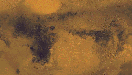
It's the original maps from the Viking mission provided by NASA and implemented into Google Mars as an overlay option. You can actually launch Google Mars, activate the overlay and see for yourself.
I don't know whether the black areas used to be elevations at some point in time, but they do look as if they were exposed to something whereas the lighter areas were not. But that's my amateurish interpretation, I have really no idea and just noticed this strange similarity ...
P.S.: Thanks for all your replies up to now ... I'm glad I'm not the only one seeing this!
edit on 17-6-2013 by jeep3r because:
text
OP, I think your post has the possibility of being close to the truth. I am not saying it is because there is far more than what we see out there but
it seems possible for my knowledge. Venus and Mars would make sense most of all. Losing our Ozone would probably dry our planet out which cause it to
shrink in size. Also the map seems decently identical.
reply to post by jeep3r
Interesting to say the least, I've always thought about Mars being in the (understood) habitable zone before Earth was. I never really though about how the planet was made up before and it's an interesting concept in how it would compare to the Earth.
All planets have an equator with a north and south pole, so under similar conditions I don't see why land wouldn't form the same. I'm no expert but it's certainly an interesting thought.
Hot Dog - He's right! Nice find, Jeep3r!
I think it's a coincidence, but it is uncanny.
Here's my latest Gigapan for you, OP, in return.
gigapan.com...
I think it's a coincidence, but it is uncanny.
Here's my latest Gigapan for you, OP, in return.
gigapan.com...
lol me tooo! but i highly doubt it its one of my dreams to be in space
edit on 17-6-2013 by Xeno23 because: (no reason given)
Funny how you only compare it with the way the land looks now.
If you get what I'm saying.
People will see anything they want. If they see a rabbit, does it mean rabbits once inhabited Mars?
If you get what I'm saying.
People will see anything they want. If they see a rabbit, does it mean rabbits once inhabited Mars?
Earth and Mars are not the same size and I don't think those dark spots are continents. Your also rotating the planet around to line up the blots
with the Earth image. Just look at high rez pictures of Mars available online and compare them to your picture. I think your just letting your brain
make the shapes for you out of blurry pictures. That's what our brains do. I have been watching Brain Games on TV lately and its pretty informative.
reply to post by impaired
I don't mean to go off topic, but have you zoomed right into the base of the large rock on the right of your pan? At least one particularly interesting hair band shaped thing in the shadows. Certainly does not look like a rock to me......
(Sorry - I couldn't work out how to imbed or link to the zoomed in image)
Rat
The region that vaguely resembles Africa is actually two named albedo features; Terra Tyrrhena and Syrtis Major Planum.
The region that barely resembles South America is immediately to the east of "Africa" and is rotated 90º. It is composed of Terra Sabaea and Terra Meridiani.
As can be seen however, the albedo features don't have much relationship to the actual topography.
mola.gsfc.nasa.gov...
The region that barely resembles South America is immediately to the east of "Africa" and is rotated 90º. It is composed of Terra Sabaea and Terra Meridiani.
As can be seen however, the albedo features don't have much relationship to the actual topography.
mola.gsfc.nasa.gov...
edit on 6/17/2013 by Phage because: (no reason given)
reply to post by Phage
Thanks for shedding some light on this, Phage!
Official page of the Viking image set from NASA's photo journal
The image referenced above is the one used for the overlay in Google Mars. It should represent the visible spectrum of light reflected by the martian topography. But I understood that the laser-altimeter data from the MOLA instrument (MGS) shows that current elevation data does not relate to coloring or shading, which makes sense.
Frankly, I was intrigued by the similarity of the shaded areas (rotated ot not) and was starting to think about continental drift, rising ocean levels, millions of years of planetary evolution and, ultimately, some cataclysmic event leading to what can be seen in the OP, in a different dimension of space & time.
But as I mentioned in the beginning: I'll be happy to dismiss such thoughts due to the lack of any further evidence. Thanks again for your input!
edit on 17-6-2013 by jeep3r because: text
Originally posted by fiftyfifty
Good find! It begs the question, were we once on Mars before we terra-formed Earth as a replica when we knew life on Mars was eventually going to become impossible? Is Venus next? How about a whole new theory that Venus is purposely being shrouded by what appears to be a thick atmosphere while it undergoes terraformation?
EDIT: OR what if Venus and Mars were previously inhabited and they had to move to Earth as their planets became more uninhabitable. Would explain a lot of the ancient civilisations, cultural and religious differences. Bloody foreigners!edit on 17-6-2013 by fiftyfifty because: (no reason given)
If you look at Google Maps, and look above the UK, there's a depression in the ocean that looks like a mold for the UK. There are legends that great wizards created the UK by scooping out land from the ocean and placing it beside Europe. Geologists say that the UK was raised upwards in the South caused by ice sheets pushing down on the Northern side.
reply to post by impaired
Holy crap dude.
On your gigapan, far right, under the shadow of the large rock formation, something that was once circular now lays part buried and broken, but nevertheless obviously circular......
Holy crap dude.
On your gigapan, far right, under the shadow of the large rock formation, something that was once circular now lays part buried and broken, but nevertheless obviously circular......
see i knew it!!
nice thread dude
great theory to think about
and like yours.. it ended up in skunk works!
nice thread dude
great theory to think about
and like yours.. it ended up in skunk works!
edit on 17-6-2013 by thePharaoh because: (no reason given)
im gonna focus in on where the pyramids should be
are there any virtual models of mars? google mars etc
i got to comment here
planet size can differ due to a molten core
angular inclinations can happen due to precession and interference
as for space time...factor out the observer
peace
are there any virtual models of mars? google mars etc
i got to comment here
I'm fully aware that this might sound stupid and would require making truly absurd assumptions about things like planet size, angular inclinations, space-time etc
planet size can differ due to a molten core
angular inclinations can happen due to precession and interference
as for space time...factor out the observer
peace
edit on 17-6-2013 by thePharaoh because: (no reason given)
Wow, so NASA has been being lazy and sending their rovers and satellites forward in time instead of heading out to Mars? Just kidding. This thread was
a totally new concept.
here OP
i think this image will help you with your comparisons
www.celestiamotherlode.net...
and
www.celestiamotherlode.net...
they are from NASA - project blue marble
heres the website with more images of earths terrain
www.celestiamotherlode.net...
peace
i think this image will help you with your comparisons
www.celestiamotherlode.net...
and
www.celestiamotherlode.net...
they are from NASA - project blue marble
heres the website with more images of earths terrain
www.celestiamotherlode.net...
peace
edit on 17-6-2013 by thePharaoh because: (no reason given)
i read a book by richard hoagland that stated the north and south crusts of mars had swapped places the highlands being in the south but good find s &
f
reply to post by Ratman
Do you mean this?
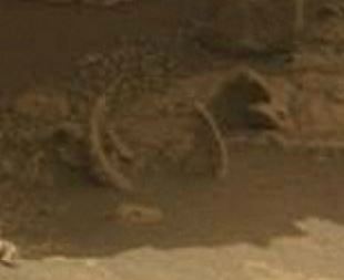
Looks like a rib cage to me.
Thanks impaired for another super cool gigapan!
gigapan.com...
Do you mean this?
Looks like a rib cage to me.
Thanks impaired for another super cool gigapan!
gigapan.com...
edit on 17-6-2013 by windword because: (no reason given)
new topics
-
Who guards the guards
US Political Madness: 1 hours ago -
Has Tesla manipulated data logs to cover up auto pilot crash?
Automotive Discussion: 3 hours ago -
whistleblower Captain Bill Uhouse on the Kingman UFO recovery
Aliens and UFOs: 8 hours ago -
1980s Arcade
General Chit Chat: 10 hours ago -
Deadpool and Wolverine
Movies: 11 hours ago
top topics
-
Lawsuit Seeks to ‘Ban the Jab’ in Florida
Diseases and Pandemics: 15 hours ago, 20 flags -
Starburst galaxy M82 - Webb Vs Hubble
Space Exploration: 17 hours ago, 13 flags -
CIA botched its handling of sexual assault allegations, House intel report says
Breaking Alternative News: 13 hours ago, 8 flags -
15 Unhealthiest Sodas On The Market
Health & Wellness: 17 hours ago, 6 flags -
whistleblower Captain Bill Uhouse on the Kingman UFO recovery
Aliens and UFOs: 8 hours ago, 6 flags -
1980s Arcade
General Chit Chat: 10 hours ago, 4 flags -
Deadpool and Wolverine
Movies: 11 hours ago, 4 flags -
Teenager makes chess history becoming the youngest challenger for the world championship crown
Other Current Events: 12 hours ago, 3 flags -
Who guards the guards
US Political Madness: 1 hours ago, 1 flags -
Has Tesla manipulated data logs to cover up auto pilot crash?
Automotive Discussion: 3 hours ago, 0 flags
active topics
-
Has Tesla manipulated data logs to cover up auto pilot crash?
Automotive Discussion • 2 • : seekshelter -
Candidate TRUMP Now Has Crazy Judge JUAN MERCHAN After Him - The Stormy Daniels Hush-Money Case.
Political Conspiracies • 622 • : Lazy88 -
Scientists Say Even Insects May Be Sentient
Science & Technology • 55 • : AdultMaleHumanUK -
"We're All Hamas" Heard at Columbia University Protests
Social Issues and Civil Unrest • 201 • : TheWoker -
-@TH3WH17ERABB17- -Q- ---TIME TO SHOW THE WORLD--- -Part- --44--
Dissecting Disinformation • 610 • : Justoneman -
Lawsuit Seeks to ‘Ban the Jab’ in Florida
Diseases and Pandemics • 24 • : VariedcodeSole -
23,000 Dead People Registered Within a Two Week Period In One State
US Political Madness • 40 • : IndieA -
whistleblower Captain Bill Uhouse on the Kingman UFO recovery
Aliens and UFOs • 7 • : pianopraze -
CIA botched its handling of sexual assault allegations, House intel report says
Breaking Alternative News • 6 • : watchitburn -
They Killed Dr. Who for Good
Rant • 63 • : grey580