It looks like you're using an Ad Blocker.
Please white-list or disable AboveTopSecret.com in your ad-blocking tool.
Thank you.
Some features of ATS will be disabled while you continue to use an ad-blocker.

Severe Weather Threat moving towards the East Coast. - Thursday, June 13th
page: 1share:
A very intense storm system is currently tracking towards the Eastern U.S..
This system is capable of producing some potentially dangerous severe weather hazards.
If conditions warrant, some of these hazards could become extreme.
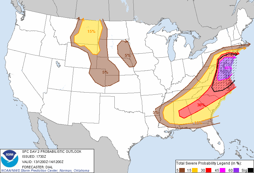 www.spc.noaa.gov...
I wanted to share this - as it's always a good idea to be prepared, and stay informed.
Especially if you're are in the path of these storms.
Be safe, Everyone!
_________
*Reminder -
*This is an ongoing situation.
(Radar Loop - Thursday, June 13 - 12:15am EST)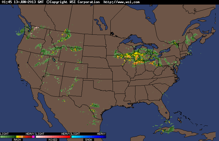
This system is capable of producing some potentially dangerous severe weather hazards.
If conditions warrant, some of these hazards could become extreme.
I wanted to share this - as it's always a good idea to be prepared, and stay informed.
Especially if you're are in the path of these storms.
...MID ATLANTIC REGION...
SWLY WINDS AHEAD OF THE DEVELOPING CYCLONE WILL TRANSPORT UPPER 60S DEWPOINTS THROUGH PRE-FRONTAL WARM SECTOR BENEATH RESIDUAL PLUME OF 7 C/KM MID LEVEL LAPSE RATES. THE ATMOSPHERE IS EXPECTED TO BECOME MODERATELY UNSTABLE AS DIABATIC WARMING COMMENCES WITH MLCAPE FROM 2000-3000 J/KG POSSIBLE. MEANWHILE...STRONGER WINDS IN THE 700-500 MB LAYER ROUNDING BASE OF AMPLIFYING SHORTWAVE TROUGH WILL SPREAD OVER THE WARM SECTOR DURING THE AFTERNOON. STRENGTHENING DEEP LAYER WLY WINDS SHOULD RESULT IN A DOWNSLOPING REGIME IMMEDIATELY EAST OF SRN/CNTRL APPALACHIANS...SUGGESTING IT MIGHT BE DIFFICULT FOR ANY ONGOING STORMS SURVIVE CROSSING THE MOUNTAINS. HOWEVER...PRE FRONTAL TROUGH/CONVERGENCE AXIS WILL LIKELY EVOLVE FARTHER EAST FROM THE CNTRL CAROLINAS INTO CNTRL/ERN VA. ADDITIONAL STORMS WILL LIKELY DEVELOP ALONG THIS CONVERGENCE ZONE OR AS COLD FRONT OVERTAKES THE DESTABILIZING WARM SECTOR. DEEP LAYER WIND PROFILES WILL BE LARGELY UNIDIRECTIONAL WITH SWLY FLOW IN THE SFC-3 KM LAYER SOUTH OF SFC LOW. THE 0-6 KM VERTICAL SHEAR OF 30-40 KT WILL SUPPORT POTENTIAL FOR A FEW SUPERCELLS ESPECIALLY WITHIN 2-3 HOURS OF INITIATION. HOWEVER...TENDENCY MAY BE FOR SOME OF THIS ACTIVITY TO EVOLVE INTO LINE SEGMENTS WITH LEWP/BOW STRUCTURES. WIDESPREAD DAMAGING WIND AND LARGE HAIL ARE EXPECTED TO BE THE MAIN THREATS...THOUGH A FEW TORNADOES CANNOT BE RULED OUT.
...ERN MT AND THE NRN HIGH PLAINS REGION...
COLD FRONT AND ASSOCIATED UPPER TROUGH WILL ADVANCE EWD INTO A DESTABILIZING AFTERNOON AIRMASS. EXPECT ISOLATED THUNDERSTORMS TO DEVELOP -- INITIALLY OVER CENTRAL AND ERN MT AND ADJACENT NERN WY. WHILE STRONG CAPPING -- OWING TO THE PRECEDING INFLUENCE OF UPPER RIDGE -- SUGGESTS THAT COVERAGE WILL BE LIMITED...STORMS WHICH DO DEVELOP WILL LIKELY BECOME SEVERE/SUPERCELLULAR GIVEN MODERATE INSTABILITY AND AMPLE VEERING/SHEAR. HAIL AND DAMAGING WINDS WILL BE THE PRIMARY SEVERE THREATS THROUGH THE AFTERNOON. STORMS SHOULD SPREAD EWD ACROSS ERN MT TOWARD WRN SD INTO THE EVENING...AS A SELY LOW-LEVEL JET INCREASES ACROSS THE HIGH PLAINS. SHEAR WILL CONTINUE TO FAVOR SEVERE POTENTIAL...WITH CONTINUED THREAT FOR DAMAGING WINDS AND HAIL AND POSSIBLY AN ISOLATED TORNADO.
www.spc.noaa.gov...
...SERN STATES...
LOW 70S BOUNDARY LAYER DEWPOINTS ARE IN PLACE AND WILL SUPPORT MODERATE INSTABILITY /2000-2500 J/KG MLCAPE/ AS THE SFC LAYER WARMS AND DESTABILIZES DURING THE AFTERNOON. A BELT OF STRONGER MID-UPPER WINDS WILL DROP SEWD OVER THE WARM SECTOR AS THE UPPER TROUGH AMPLIFIES THE EAST OF THIS REGION. THIS WILL RESULT IN NWLY DEEP LAYER WINDS AND EFFECTIVE SHEAR OF 30-35 KT THAT WILL BECOME AT LEAST MARGINALLY SUPPORTIVE OF ORGANIZED STORMS. CURRENT INDICATIONS ARE THAT A FEW STORMS MAY BE ONGOING OVER THE TN VALLEY REGION...AND ADDITIONAL ACTIVITY MAY DEVELOP/INTENSIFY ALONG THE SWD MOVING OUTFLOW BOUNDARIES. DAMAGING WIND AND LARGE HAIL WILL BE THE MAIN THREATS.
Be safe, Everyone!
_________
*Reminder -
*This is an ongoing situation.
(Radar Loop - Thursday, June 13 - 12:15am EST)
edit on 13-6-2013 by iunlimited491 because: (no reason given)
Can we have some of that in Arizona? It only like 112 satanical degrees here in Phoenix.
edit on 12-6-2013 by solarstorm because: (no reason
given)
reply to post by iunlimited491
It arrived here on the west side of Ohio about an hour ago.
Thanks for the Heads Up. .. .. .. .
I shoulda caught your 6:00 forecast.
EDIT:
It has rained a little but the Lightning and Wind are pretty intense.
It arrived here on the west side of Ohio about an hour ago.
Thanks for the Heads Up. .. .. .. .
I shoulda caught your 6:00 forecast.
EDIT:
It has rained a little but the Lightning and Wind are pretty intense.
edit on 13-6-2013 by ShadellacZumbrum because: (no reason
given)
edit on 13-6-2013 by ShadellacZumbrum because: (no reason given)
reply to post by solarstorm
LOL
Yes, our monsoon season wouldn't be so bad if the temps were alot cooler.
LOL
Yes, our monsoon season wouldn't be so bad if the temps were alot cooler.
Woo, go brown into yellow! Seriously though, I'm happy that it looks like I'll be fairly safe but for those in the more extreme weather conditions
please be safe and take care of your families. Severe events are a time to stick together and help out each other. There's a light thunderstorm right
now but that's about it. Annoying that it's 2:40 AM and I want to sleep but other than that nothing too bad. Tomorrow we have flood watches for
possible downpours but beyond that I think my neck of the woods in PA will be alright.
^^
Thanks, 2 Everyone!
It's not a problem on my end. I love following these things.
_________
Continuing...
Important factors in all of this, are the speed at which the 'derecho' moves towards the Atlantic - and the temperatures of the places it has yet to cross.
Temps in the Mid-Atlantic states are supposed to rise quickly during the morning hours.
Eventually reaching 80-90 degrees by the early-afternoon.
This can destabilize the atmosphere, as convection temperatures would be ideal - causing severe weather.
If these cells converged with perfect convection temps...
and the atmosphere continued to decline in stability...
The outcome could be dangerous.
Here's the latest update from the SPC(NWS):
www.spc.noaa.gov...
...POTENTIALLY SIGNIFICANT SEVERE THUNDERSTORM EVENT POSSIBLE ACROSS THE MIDDLE ATLANTIC THURSDAY...
...MIDDLE ATLANTIC...
WELL DEFINED SHORT-WAVE TROUGH IS DIGGING ESEWD ACROSS THE MIDWEST
INTO THE OH VALLEY EARLY THIS MORNING. LATEST MODEL GUIDANCE
SUGGESTS A FOCUSED AREA OF HEIGHT FALLS WILL SPREAD ACROSS THE OH
VALLEY INTO THE MIDDLE ATLANTIC REGION DURING THE DAY WITH TROUGH
AXIS EXPECTED TO TRANSLATE TO A POSITION FROM WRN PA INTO ERN TN AT
13/00Z. A CORRIDOR OF 50KT+ MID LEVEL FLOW SHOULD SPREAD ACROSS WV
INTO THE DELMARVA BY SUNRISE ENHANCING DEEP LAYER SHEAR/MEAN WIND
ACROSS MUCH OF THE EAST COAST...ESPECIALLY AREAS NORTH OF NC.
GREATEST AREA OF CONCERN WILL EXTEND ACROSS VA INTO THE DELMARVA
REGION WHERE LOW LEVEL SHEAR PROFILES ARE EXPECTED TO BE MOST
FAVORABLE FOR POTENTIAL TORNADO DEVELOPMENT.
EARLY THIS MORNING AN EXPANSIVE AND MATURE MCS HAS EVOLVED AHEAD OF
THE SHORT-WAVE TROUGH OVER LOWER MI/NRN IND/OH...WITH A WELL DEFINED
MCS APPROACHING THE WRN END OF LAKE ERIE. LEADING EDGE OF THIS MCS
IS SURGING ESEWD AT ROUGHLY 40KT WHICH WOULD ALLOW SQUALL LINE TO
SPREAD EAST OF THE APPALACHIANS BY SUNRISE. LATEST MODEL GUIDANCE
DOES NOT PROJECT THIS CONVECTIVE COMPLEX EAST OF THE MOUNTAINS EARLY
IN THE PERIOD AND CONSIDERABLE UNCERTAINTY EXISTS WHETHER THIS
ACTIVITY WILL DIE OFF OR PROGRESS OFF THE ATLANTIC COAST. IF THIS
MCS ADVANCES ACROSS THE MIDDLE ATLANTIC EARLY IN THE PERIOD THEN
CONVECTIVE DEVELOPMENT IN ITS WAKE MAY BE REDUCED IN BOTH INTENSITY
AND AREAL COVERAGE.
IF SUFFICIENT DESTABILIZATION OCCURS ACROSS THE MIDDLE ATLANTIC IT
APPEARS LARGE SCALE FORCING WILL TIME FAVORABLY FOR MID DAY TSTM
INTENSIFICATION FROM SRN PA...SWD ACROSS MD/VA. FORECAST SOUNDINGS
SUGGEST SFC TEMPERATURES WILL WARM RAPIDLY INTO THE MID 80S WHICH IS
MORE THAN ADEQUATE FOR BREACHING CONVECTIVE TEMPERATURES. WITH
40-45KT CLOUD LAYER MEAN WIND EXPECTED ACROSS THIS REGION IT WOULD
SEEM PROBABLE THAT ANY STORMS THAT FORM WILL MOVE QUICKLY AND COULD
POSE A SIGNIFICANT WIND THREAT. NEAR THE WARM FRONT ACROSS SERN PA
INTO SRN NJ SHEAR PROFILES WILL PROVE A BIT MORE FAVORABLE FOR
SUPERCELLS CAPABLE OF PRODUCING TORNADOES. 10 PERCENT TORNADO PROBS
WILL BE FOCUSED ALONG THIS CORRIDOR.
edit on 13-6-2013 by iunlimited491 because: (no reason given)
edit on 13-6-2013 by iunlimited491 because: (no reason
given)

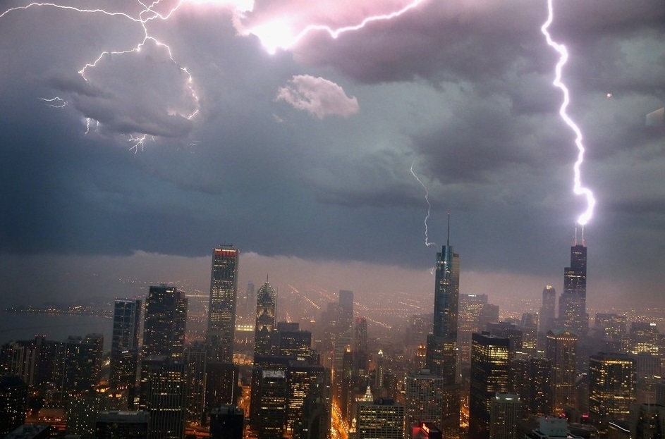
reply to post by goou111
Awesome pictures!
_________________
Very massive storm...
If this hangs around,
and meets up with the warmer temps this afternoon...
It could make for quite a show...
Thursday, June 13 - 4:52am EST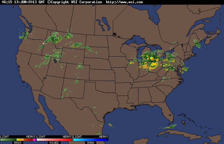
Awesome pictures!
_________________
Very massive storm...
If this hangs around,
and meets up with the warmer temps this afternoon...
It could make for quite a show...
Thursday, June 13 - 4:52am EST
edit on 13-6-2013 by iunlimited491 because: (no reason given)
NOTE:
(The link below the pic in the OP - will take you to the 'DAY 2' convection outlook map -
which is now June, 14th.)
('THIS' MAP & LINK - IS THE 'DAY 1' CONVECTION OUTLOOK MAP - SINCE TODAY, IS NOW OFFICIALLY THURSDAY JUNE 13)
Day 1 Convective Outlook - Thursday June, 13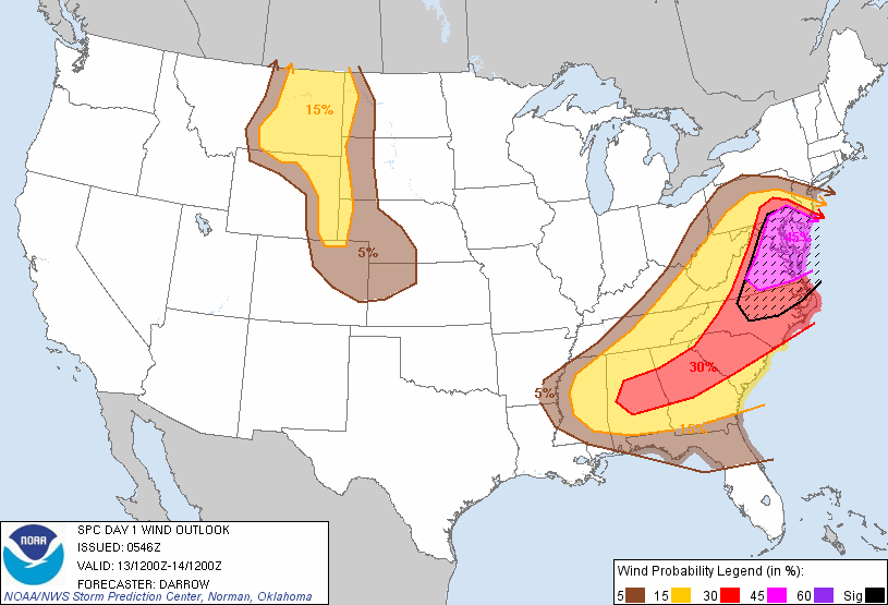 www.spc.noaa.gov...
(The link below the pic in the OP - will take you to the 'DAY 2' convection outlook map -
which is now June, 14th.)
('THIS' MAP & LINK - IS THE 'DAY 1' CONVECTION OUTLOOK MAP - SINCE TODAY, IS NOW OFFICIALLY THURSDAY JUNE 13)
Day 1 Convective Outlook - Thursday June, 13
reply to post by iunlimited491
I'm in NJ and glad to be off today. Seems it's gonna hit us anytime, some workers checking poles right in front of my home now.
www.nj.com...-rpt-1
I'm in NJ and glad to be off today. Seems it's gonna hit us anytime, some workers checking poles right in front of my home now.
A major storm system is over New Jersey, bringing possible flooding and power outages along with a risk of small tornadoes and powerful "super cell" thunderstorms.
www.nj.com...-rpt-1
While in Chicago Lord Stanley was in town and the Hawks won btw We braced ourselves for this storm. Sox game was cancelled, work was cancelled...
Swimming lessons cancelled.... People putting up storm baracades... And then "IT" came... We were not impressed, I heard the "Super Cells"
dissapated as they went by Chicago and was worse more south and east of us... My boss comes from La Porte, Indiana and he didn't say a word about the
storm either... So I take it as there was no flooding and minimal damage.... Not that there weren't some unfortunate damages taken to some
individuals, I guess I got lucky.
Best of luck on the East Coast, stay safe and god speed.
Best of luck on the East Coast, stay safe and god speed.
Right outside of DC, the sky turned black for a few minutes around 8am, now there is nothing, it is rather nice out. Supposidely more is to come
Meteorologists were even warning about the possibility of a weather event called a derecho, which is a storm of strong straight-line winds spanning at least 240 miles.
What is a derecho?
"It's a cluster of thunderstorms that congeal into a line, and that line will then start moving east or southeast, and as it progresses the winds increase and produce damage along that path," said Jim Keeney, weather program manager at the National Weather Service's office in Kansas City, Mo.
Derechos differ to tornadoes in scale. Tornadoes are more isolated events - a single parent storm or a single thunderstorm that hits a certain area. A derecho is a very large weather event that covers a much greater area.
www.cbsnews.com...
The first line is moving into the east tn valley right now, about an hour or so from knoxville I guess. No watches or warning yet, but its warm and
humid outside, and the wind is blowing pretty gusty at times.
Sorry everybody, I think this may be my fault. It seems my patio furniture has some kind of power to make it rain, for every time I put it out, it
pours for days.
edit on 13-6-2013 by tjack because: (no reason given)
Originally posted by solarstorm
Can we have some of that in Arizona? It only like 112 satanical degrees here in Phoenix.edit on 12-6-2013 by solarstorm because: (no reason given)
Ahh, but it's a dry heat!
When I was in Saudi Arabia folks used to tell me that and for some reason I had the incredible urge to smack the spit out of them.
Buck up, you can look back on all this and smile in December.
Gah, it hasn't even hit here and doesn't look to be dangerous or if it even WILL hit and they've canceled bingo. What am I gonna do without
bingo this week, I'll have nowhere else to stir up trouble. That and I was going to use that as another date with the new fella just to test
how much he's willing to get into if he'll sit and play bingo for three hours.
new topics
-
Who guards the guards
US Political Madness: 1 hours ago -
Has Tesla manipulated data logs to cover up auto pilot crash?
Automotive Discussion: 3 hours ago -
whistleblower Captain Bill Uhouse on the Kingman UFO recovery
Aliens and UFOs: 8 hours ago -
1980s Arcade
General Chit Chat: 10 hours ago -
Deadpool and Wolverine
Movies: 11 hours ago
top topics
-
Lawsuit Seeks to ‘Ban the Jab’ in Florida
Diseases and Pandemics: 15 hours ago, 20 flags -
Starburst galaxy M82 - Webb Vs Hubble
Space Exploration: 17 hours ago, 13 flags -
CIA botched its handling of sexual assault allegations, House intel report says
Breaking Alternative News: 13 hours ago, 8 flags -
whistleblower Captain Bill Uhouse on the Kingman UFO recovery
Aliens and UFOs: 8 hours ago, 8 flags -
Deadpool and Wolverine
Movies: 11 hours ago, 4 flags -
1980s Arcade
General Chit Chat: 10 hours ago, 4 flags -
Teenager makes chess history becoming the youngest challenger for the world championship crown
Other Current Events: 12 hours ago, 3 flags -
Who guards the guards
US Political Madness: 1 hours ago, 1 flags -
Has Tesla manipulated data logs to cover up auto pilot crash?
Automotive Discussion: 3 hours ago, 0 flags
active topics
-
Another person lights themselves on fire and dies on College campus, happened in Red Deer, Canada
Mainstream News • 28 • : seekshelter -
Candidate TRUMP Now Has Crazy Judge JUAN MERCHAN After Him - The Stormy Daniels Hush-Money Case.
Political Conspiracies • 625 • : RazorV66 -
23,000 Dead People Registered Within a Two Week Period In One State
US Political Madness • 41 • : Xtrozero -
"We're All Hamas" Heard at Columbia University Protests
Social Issues and Civil Unrest • 202 • : network dude -
They Killed Dr. Who for Good
Rant • 64 • : Lazy88 -
Deadpool and Wolverine
Movies • 2 • : chiefsmom -
Has Tesla manipulated data logs to cover up auto pilot crash?
Automotive Discussion • 2 • : seekshelter -
Scientists Say Even Insects May Be Sentient
Science & Technology • 55 • : AdultMaleHumanUK -
-@TH3WH17ERABB17- -Q- ---TIME TO SHOW THE WORLD--- -Part- --44--
Dissecting Disinformation • 610 • : Justoneman -
Lawsuit Seeks to ‘Ban the Jab’ in Florida
Diseases and Pandemics • 24 • : VariedcodeSole