It looks like you're using an Ad Blocker.
Please white-list or disable AboveTopSecret.com in your ad-blocking tool.
Thank you.
Some features of ATS will be disabled while you continue to use an ad-blocker.

Video: Peeling Back the Ice of Antarctica
page: 15
share:
link
Warning, this video contains full frontal continental nudity, which is actually pretty awesome.
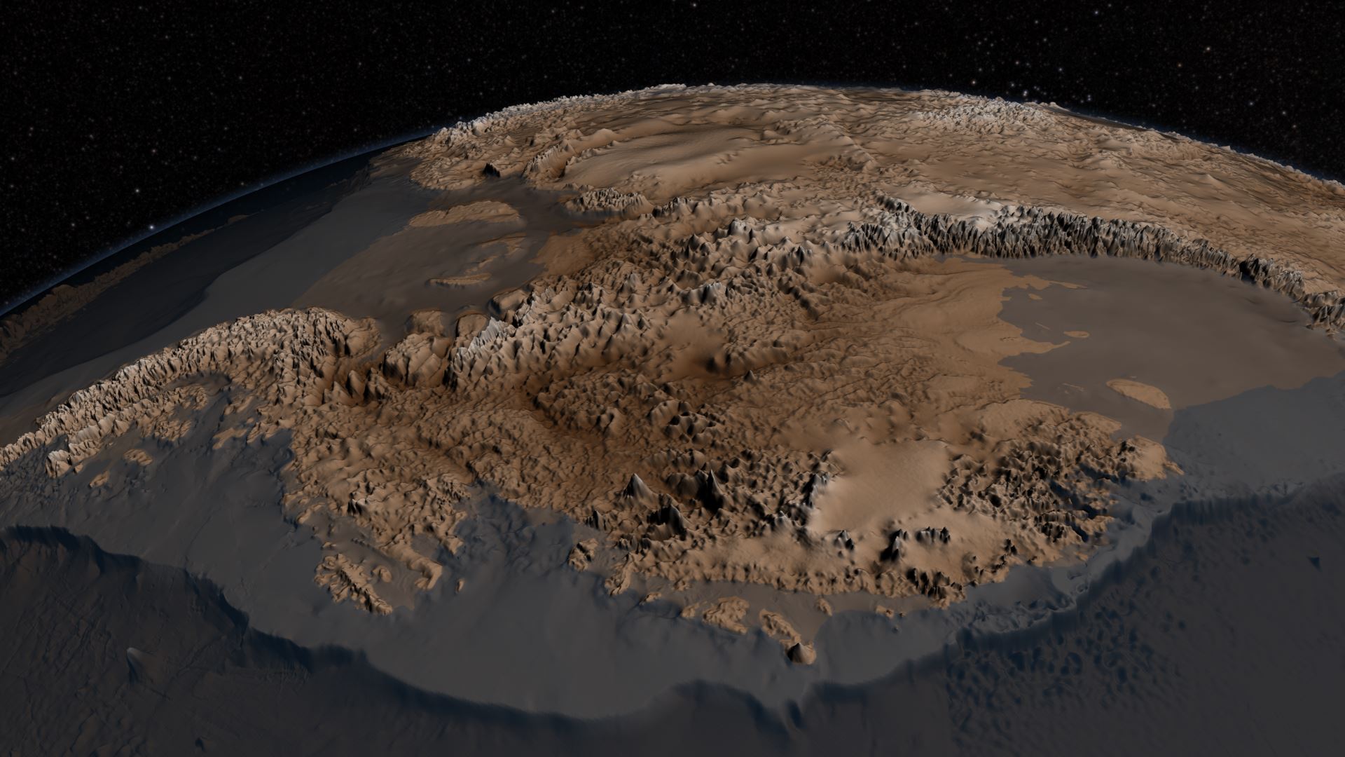
The video is short but shows a cobbled together map of the land under the ice of the antarctic.
This survey is more accurate than one they did some years ago and shows a lot of the mountainous terrain of antarctica.
Warning, this video contains full frontal continental nudity, which is actually pretty awesome.
The video is short but shows a cobbled together map of the land under the ice of the antarctic.
This survey is more accurate than one they did some years ago and shows a lot of the mountainous terrain of antarctica.
Bedmap2 was created by the British Antarctic Survey, and used decades of data to produce this detailed view of the frozen continent. NASA’s contribution to the dataset includes surface measurements from its now-retired orbiting Ice, Cloud, and Land Elevation Satellite (ICESat), and results from several years of flyovers by specialized aircraft that collected radar and other data measuring changes in the thickness of sea ice, glaciers, and ice sheets as part of Operation IceBridge.
The work improves on the decade-old Bedmap project, which virtually thawed the continent, but at lower resolution. Both maps combine information on ice thickness, bedrock topography, and surface elevation. Bedmap2 added millions of extra data points and also covers a wider swath of land than its predecessor. Over on NASA’s site, you can compare the two datasets by sliding between them.

reply to post by grey580
Nice. And that's a pretty tall mountain range running up the middle of the continent. Climbing some of those peaks could be a climber's dream vacation.
Nice. And that's a pretty tall mountain range running up the middle of the continent. Climbing some of those peaks could be a climber's dream vacation.
But, but.... where's the giant hole in the middle of it?!?
Cool vid!
Cool vid!
reply to post by iamhobo
Clearly Admiral Byrd worked with the inner earth nazis to finish the cover to keep their secret.
Clearly Admiral Byrd worked with the inner earth nazis to finish the cover to keep their secret.
It would be interesting to compare these results with the ice-free Antarctica Piri Reis map of the 16th century and other older maps of ice-free land
mass of Antarctica.
Here is a pic I got from google image search, for those of us with crap internet speeds.
It's a great image, the landscape sure looks tortured.
Bugger, I thought the pic would come out bigger than that lol
Oh well, here is the link to the full image.
www.nasa.gov...
It's a great image, the landscape sure looks tortured.
Bugger, I thought the pic would come out bigger than that lol
Oh well, here is the link to the full image.
www.nasa.gov...
edit on 6-6-2013 by LeLeu because: (no reason
given)
new topics
-
Late Night with the Devil - a really good unusual modern horror film.
Movies: 1 hours ago -
Cats Used as Live Bait to Train Ferocious Pitbulls in Illegal NYC Dogfighting
Social Issues and Civil Unrest: 2 hours ago -
The Good News According to Jesus - Episode 1
Religion, Faith, And Theology: 4 hours ago -
HORRIBLE !! Russian Soldier Drinking Own Urine To Survive In Battle
World War Three: 6 hours ago -
Bobiverse
Fantasy & Science Fiction: 9 hours ago -
Florida man's trip overseas ends in shock over $143,000 T-Mobile phone bill
Social Issues and Civil Unrest: 9 hours ago -
Former Labour minister Frank Field dies aged 81
People: 11 hours ago
top topics
-
Florida man's trip overseas ends in shock over $143,000 T-Mobile phone bill
Social Issues and Civil Unrest: 9 hours ago, 8 flags -
SETI chief says US has no evidence for alien technology. 'And we never have'
Aliens and UFOs: 13 hours ago, 7 flags -
Cats Used as Live Bait to Train Ferocious Pitbulls in Illegal NYC Dogfighting
Social Issues and Civil Unrest: 2 hours ago, 7 flags -
This is our Story
General Entertainment: 16 hours ago, 4 flags -
Former Labour minister Frank Field dies aged 81
People: 11 hours ago, 4 flags -
Bobiverse
Fantasy & Science Fiction: 9 hours ago, 3 flags -
HORRIBLE !! Russian Soldier Drinking Own Urine To Survive In Battle
World War Three: 6 hours ago, 2 flags -
Late Night with the Devil - a really good unusual modern horror film.
Movies: 1 hours ago, 2 flags -
The Good News According to Jesus - Episode 1
Religion, Faith, And Theology: 4 hours ago, 0 flags
5