It looks like you're using an Ad Blocker.
Please white-list or disable AboveTopSecret.com in your ad-blocking tool.
Thank you.
Some features of ATS will be disabled while you continue to use an ad-blocker.

Severe Weather Forecast for Texas Today 05/21/2013
page: 2share:
Originally posted by Casualboy100
reply to post by extraterrestrialentity
Storm my butt! Its flipping hot outside ugh
I hear that, and I'm about to go out into it. Well the heat should make for a very nice show once it all comes together.
Be safe
We are also now under a tornado watch until 7pm in North Central Texas. I live near Fort Hood in Lampasas Co. This watch includes counties, "BELL
BOSQUE COLLIN COMANCHE COOKE CORYELL DALLAS DENTON EASTLAND ELLIS ERATH FALLS FANNIN FREESTONE GRAYSON HAMILTON HILL HOOD HUNT JACK JOHNSON KAUFMAN
LAMPASAS LIMESTONE MCLENNAN MILLS MONTAGUE NAVARRO PALO PINTO PARKER ROCKWALL SOMERVELL STEPHENS TARRANT WISE YOUNG"
I would link the page, but because I am still trying to figure out Windows 8 and my popup blockers on my new laptop, I am having trouble and it's not allowing me to click "link" so I can share the page. So I will just give everyone the website.
www.weather.com...
Huh, weird. I just copied and pasted the website into my comment and it automatically linked it for me. Groovy.
I would link the page, but because I am still trying to figure out Windows 8 and my popup blockers on my new laptop, I am having trouble and it's not allowing me to click "link" so I can share the page. So I will just give everyone the website.
www.weather.com...
edit on 21-5-2013 by
watchdog because: (no reason given)
Huh, weird. I just copied and pasted the website into my comment and it automatically linked it for me. Groovy.
edit on 21-5-2013 by watchdog
because: (no reason given)
North East Texas here..Wood County..Very nervous here as the day gets going, all the ingredients are starting to make the predictions of sever weather
very real..I so hope it does not get too bad.
I will try and add as much local info as I can as we go through the afternoon and evening.
Yall stay safe and alert!!
Thank you fro starting this thread OP... Saved me from doing it...
I will try and add as much local info as I can as we go through the afternoon and evening.
Yall stay safe and alert!!
Thank you fro starting this thread OP... Saved me from doing it...
Texas Storm Chasers
12:40 PM: So far, all is pretty quiet. An outflow boundary extends from Saint Jo south to Mineral Wells. Storms to the west of this boundary are elevated above cool air and weak. We're watching for signs of storm development ahead of this eastward moving boundary. Short-term models suggest this may occur in the next hour across the western portions of the D/FW Metro. Storms that form east of this boundary will likely become severe. All is quiet for now, but we'll likely get more active by 2 PM.
www.facebook.com...
I will be watching these guys all day..Updates all the time.
NWS Austin / San Antonio
I guess we will see what happens as the system moves across Texas, eastward.
Stay safe everyone.

... Extremely unstable airmass poised to erupt in severe thunderstorms
with large hail and damaging winds by late afternoon through this
evening...
Rich low level Gulf moisture coupled with daytime heating and
cold air aloft will result in an extremely unstable air mass
across south central Texas from late this morning through early
evening. Thunderstorm development is expected beginning by early
this afternoon as an an upper level trough and cold front approach
from the west. Scattered thunderstorms will develop rapidly by
late afternoon... quickly becoming severe as the front encounters
this unstable air mass. The main threats will be from large hail
and damaging thunderstorm winds... however with the extreme
instability present... isolated tornadoes cannot be ruled out. Much
of the eastern half of south central Texas... mainly east of a
Kerrville to Carrizo Springs line... will be affected from late
afternoon until the early morning hours Wednesday. In
addition... rainfall amounts may average 1 to 3 inches within the
heaviest storms producing some localized flooding.
Heightened concern exists along and north of a Burnet to Austin to
Giddings line this evening... where the most unstable conditions will
reside. This area will be most at risk for very large hail and
isolated tornadoes.
www.wund.com...
I guess we will see what happens as the system moves across Texas, eastward.
Stay safe everyone.
This is a big watch box!!www.facebook.com...
 " target='_blank' class='tabOff'/>
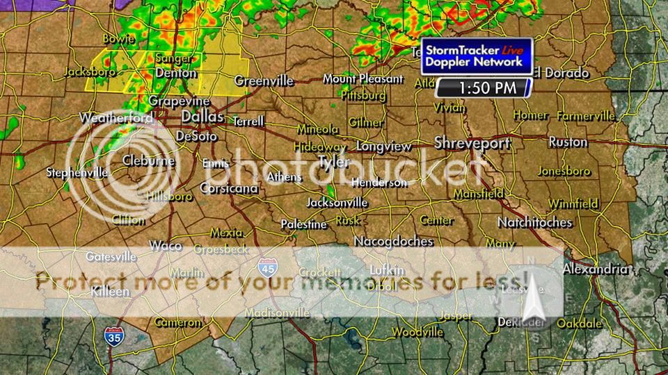
I am between Mineola and Gilmer.. Going to be a long night! Plus my family is in Dallas..
I am between Mineola and Gilmer.. Going to be a long night! Plus my family is in Dallas..
edit on 21-5-2013 by lyons666 because: (no reason
given)
000 WFUS54 KSHV 211901 TORSHV ARC081-TXC037-211930- /O.NEW.KSHV.TO.W.0043.130521T1901Z-130521T1930Z/ BULLETIN - EAS ACTIVATION REQUESTED TORNADO WARNING NATIONAL WEATHER SERVICE SHREVEPORT LA 201 PM CDT TUE MAY 21 2013 THE NATIONAL WEATHER SERVICE IN SHREVEPORT HAS ISSUED A * TORNADO WARNING FOR... CENTRAL BOWIE COUNTY IN NORTHEAST TEXAS... THIS INCLUDES THE CITIES OF...SIMMS...NEW BOSTON... SOUTH CENTRAL LITTLE RIVER COUNTY IN SOUTHWEST ARKANSAS... * UNTIL 230 PM CDT * AT 157 PM CDT...NATIONAL WEATHER SERVICE METEOROLOGISTS DETECTED A SEVERE THUNDERSTORM CAPABLE OF PRODUCING A TORNADO 6 MILES NORTH OF SIMMS...MOVING NORTHEAST AT 25 MPH. * OTHER LOCATIONS IN THE WARNING INCLUDE BUT ARE NOT LIMITED TO HOOKS AND NASH... PRECAUTIONARY/PREPAREDNESS ACTIONS... A TORNADO WARNING MEANS THAT STRONG ROTATION HAS BEEN DETECTED IN THE STORM. A TORNADO MAY ALREADY BE ON THE GROUND...OR IS EXPECTED TO DEVELOP SHORTLY. IF YOU ARE IN THE PATH OF THIS DANGEROUS STORM... MOVE INDOORS AND TO THE LOWEST LEVEL OF THE BUILDING. STAY AWAY FROM WINDOWS. IF DRIVING...DO NOT SEEK SHELTER UNDER A HIGHWAY OVERPASS. && LAT...LON 3369 9433 3345 9410 3332 9454 3346 9469 TIME...MOT...LOC 1902Z 228DEG 22KT 3345 9453
NE Texas Tornado Warning
Denton county here. I woke up around an hour ago (1:30ish), and slept through most of the current storm. So far there's just been high wind and rain.
A wind gust in my county was measured at around 73 mph. The end of this line of storms is pretty much over for my area, probably within the next 15-20
minutes. This storm is still plowing east at around 45 mph, so those east of here (Plano, Greenville, ect....) are going to be hit pretty fast, as the
current line dosent look like it's going to fall apart anytime soon.
As for tornadoes....the temperature around here is falling pretty rapidly. Im not exactly sure of the temp yesterday, but I think it was around atleast 80-85. Now it's 65 and still falling. I don't really see a chance for a tornado if it keeps getting colder. Again, I would watch out for the area East of here, plus there may be even more storms coming later today.
As for tornadoes....the temperature around here is falling pretty rapidly. Im not exactly sure of the temp yesterday, but I think it was around atleast 80-85. Now it's 65 and still falling. I don't really see a chance for a tornado if it keeps getting colder. Again, I would watch out for the area East of here, plus there may be even more storms coming later today.
Looks like the watch is being extended to the east.
twitter.com...
Tornado watch until 10pm for much of north MS, west TN, southeast AR, northeast LA, MO bootheel; incl. Memphis.
twitter.com...
www.facebook.com...
ream
Here's the latest everyone... A squall line has formed around Dallas/Fort Worth and is moving this direction. It is expected to intensify as it moves into warmer, more moist air over East Texas. The main threats will be high winds and large hail. This line won't be here until closer to the drive home time (5pm-ish). However, if any storms develop ahead of this line, they will intensify very quickly and could start to rotate. This is the activity that we are watching closely right now.
Here's the latest everyone... A squall line has formed around Dallas/Fort Worth and is moving this direction. It is expected to intensify as it moves into warmer, more moist air over East Texas. The main threats will be high winds and large hail. This line won't be here until closer to the drive home time (5pm-ish). However, if any storms develop ahead of this line, they will intensify very quickly and could start to rotate. This is the activity that we are watching closely right now.
Originally posted by Casualboy100
YEs I love rain! Will it hit San marcos?
Howdie neighbor! Yes we can take all the rain we can get for the river, nothing too severe though. I'm just south of you in Fentress, on the river, it needs a good washing out, but not too much, I don't want to wash away.
love, heather
reply to post by lyons666
Be safe in that car. What are the chances that you could leave work early? Gotta camera?
Be safe in that car. What are the chances that you could leave work early? Gotta camera?
Tornado Warning for
Poinsett County, AR
Tornado warnings in Arkansas now. Stay safe everyone.
THE NATIONAL WEATHER SERVICE IN MEMPHIS HAS ISSUED A * TORNADO WARNING FOR... EASTERN POINSETT COUNTY IN EASTERN ARKANSAS... * UNTIL 345 PM CDT * AT 320 PM CDT... NATIONAL WEATHER SERVICE DOPPLER RADAR INDICATED A SEVERE THUNDERSTORM PRODUCING A TORNADO 9 MILES SOUTHEAST OF HARRISBURG... MOVING NORTHEAST AT 30 MPH.
Tornado warnings in Arkansas now. Stay safe everyone.
reply to post by Witness2008
Im thinking about staying home(not at work yet) go in at 5-9pm..my girls will be here..12 and 18, but I still worry they wouldnt get in the safe room in time..
Im thinking about staying home(not at work yet) go in at 5-9pm..my girls will be here..12 and 18, but I still worry they wouldnt get in the safe room in time..
edit on 21-5-2013 by lyons666 because: (no reason given)
reply to post by lyons666
Good luck with what ever you decide. I'll be watching your neck of the woods for sure.
Good luck with what ever you decide. I'll be watching your neck of the woods for sure.
You folks that are getting all weirded out about a normal springtime weather forecast must be transplanted yankees.... Native Texans go outside and
enjoy the weather regardless of what it's doing... Ya'll act like you want to live forever.
new topics
-
Bobiverse
Fantasy & Science Fiction: 1 hours ago -
Florida man's trip overseas ends in shock over $143,000 T-Mobile phone bill
Social Issues and Civil Unrest: 1 hours ago -
Former Labour minister Frank Field dies aged 81
People: 3 hours ago -
SETI chief says US has no evidence for alien technology. 'And we never have'
Aliens and UFOs: 5 hours ago -
This is our Story
General Entertainment: 8 hours ago -
President BIDEN Vows to Make Americans Pay More Federal Taxes in 2025 - Political Suicide.
2024 Elections: 10 hours ago -
Ode to Artemis
General Chit Chat: 11 hours ago
top topics
-
President BIDEN Vows to Make Americans Pay More Federal Taxes in 2025 - Political Suicide.
2024 Elections: 10 hours ago, 14 flags -
Should Biden Replace Harris With AOC On the 2024 Democrat Ticket?
2024 Elections: 16 hours ago, 6 flags -
One Flame Throwing Robot Dog for Christmas Please!
Weaponry: 14 hours ago, 6 flags -
Don't take advantage of people just because it seems easy it will backfire
Rant: 15 hours ago, 4 flags -
Ditching physical money
History: 14 hours ago, 4 flags -
SETI chief says US has no evidence for alien technology. 'And we never have'
Aliens and UFOs: 5 hours ago, 4 flags -
Ode to Artemis
General Chit Chat: 11 hours ago, 3 flags -
Former Labour minister Frank Field dies aged 81
People: 3 hours ago, 3 flags -
VirginOfGrand says hello
Introductions: 16 hours ago, 2 flags -
This is our Story
General Entertainment: 8 hours ago, 2 flags
active topics
-
Election Year 2024 - Interesting Election-Related Tidbits as They Happen.
2024 Elections • 71 • : WeMustCare -
President BIDEN Vows to Make Americans Pay More Federal Taxes in 2025 - Political Suicide.
2024 Elections • 46 • : 5thHead -
The Reality of the Laser
Military Projects • 36 • : Zaphod58 -
So this is what Hamas considers 'freedom fighting' ...
War On Terrorism • 256 • : DBCowboy -
Breaking Baltimore, ship brings down bridge, mass casualties
Other Current Events • 475 • : ArMaP -
Bobiverse
Fantasy & Science Fiction • 1 • : TzarChasm -
SETI chief says US has no evidence for alien technology. 'And we never have'
Aliens and UFOs • 22 • : Ophiuchus1 -
Police clash with St George’s Day protesters at central London rally
Social Issues and Civil Unrest • 43 • : SprocketUK -
Mood Music Part VI
Music • 3097 • : TheWoker -
Post A Funny (T&C Friendly) Pic Part IV: The LOL awakens!
General Chit Chat • 7132 • : watchitburn