It looks like you're using an Ad Blocker.
Please white-list or disable AboveTopSecret.com in your ad-blocking tool.
Thank you.
Some features of ATS will be disabled while you continue to use an ad-blocker.

Wow! Monster hurricane on Saturn spied by NASA spacecraft
page: 16
share:
I was reading this article by Yahoo and I thought it would be cool enough to share.
You have to take in that Saturn is a gas giant and it is interesting why the planet will experience a similar, but larger hurricane than Earth.
The article continues to explain how similar and different hurricanes are on Earth and Saturn. As well that scientist are going to take a close look to understand hurricanes on Saturn.
Source
Source 2
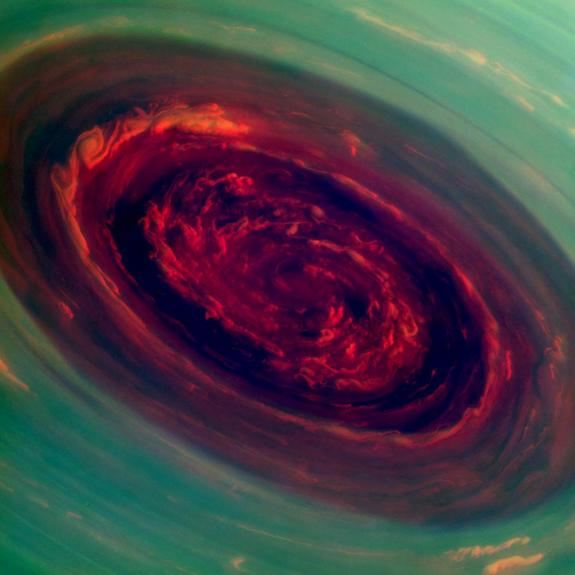
Spectacular new images from a NASA spacecraft orbiting Saturn have captured the most detailed views ever of an enormous hurricane churning around the ringed planet's north pole.
The stunning new images and video of the Saturn hurricane, which were taken by NASA's Cassini probe, show that the storm's eye is 1,250 miles (2,000 kilometers) wide — about 20 times bigger than typical hurricane eyes on Earth. And the Saturn maelstrom is more powerful than its Earth counterparts, with winds at its outer edge whipping around at 330 mph (530 km/h).
You have to take in that Saturn is a gas giant and it is interesting why the planet will experience a similar, but larger hurricane than Earth.
"We did a double take when we saw this vortex because it looks so much like a hurricane on Earth," Cassini imaging team member Andrew Ingersoll, of Caltech in Pasadena, said in a statement. "But there it is at Saturn, on a much larger scale, and it is somehow getting by on the small amounts of water vapor in Saturn's hydrogen atmosphere."
Saturn's hurricane swirls inside a mysterious, six-sided vortex. Unlike hurricanes on Earth, which tend to drift northward as our planet rotates, the Saturn storm and its hexagonal vortex have been camped out at the north pole for a while. "The polar hurricane has nowhere else to go, and that's likely why it's stuck at the pole," Kunio Sayanagi, a Cassini imaging team associate at Hampton University in Hampton, Va., said in a statement.
The article continues to explain how similar and different hurricanes are on Earth and Saturn. As well that scientist are going to take a close look to understand hurricanes on Saturn.
Source
Source 2
Wow, that's an incredible photo! Let's hope there is more to come
reply to post by sarahlm
Yes, it is. I was thinking if I was in that storm I would be thrown like a rag doll. Thankfully we do not have real bad storms like this on Earth. There bad, but not as bad and big as that.
Yes, it is. I was thinking if I was in that storm I would be thrown like a rag doll. Thankfully we do not have real bad storms like this on Earth. There bad, but not as bad and big as that.
I don't want to go there. Years, many years ago I read a story (from Heinlein or Clarke) about some brave cyborg-man sailing in a vessel inside
Jupiter's athmosphere - the sheer dimensions of "looking at some clouds below, realising that they were in fact many kilometers down" are
breathtaking.
Now imagine being in the swirl of a hurrican thousands of kilometers across, reaching the huge, impossible huge eye of it..
Looking into this tumultuous mass of clouds around, above and below you - my mind would have been blown.
Now imagine being in the swirl of a hurrican thousands of kilometers across, reaching the huge, impossible huge eye of it..
Looking into this tumultuous mass of clouds around, above and below you - my mind would have been blown.
reply to post by ManFromEurope
Reading this reminded me on the video of the planets and the Sun in our Solar System. How the outer planets were gas giants. Wikipedia mentions it is possible for Jupiter to have a core, but since the large gas planet has so many storms and what not will make it difficult to land on the planet. That's if there is a solid core that we can land on.
If we could psychically explore Jupiter it would literally be an alien world because of how different it is from Earth and how our bodies are not adaptable for a large gas giant.
I don't want to go there. Years, many years ago I read a story (from Heinlein or Clarke) about some brave cyborg-man sailing in a vessel inside Jupiter's athmosphere - the sheer dimensions of "looking at some clouds below, realising that they were in fact many kilometers down" are breathtaking.
Reading this reminded me on the video of the planets and the Sun in our Solar System. How the outer planets were gas giants. Wikipedia mentions it is possible for Jupiter to have a core, but since the large gas planet has so many storms and what not will make it difficult to land on the planet. That's if there is a solid core that we can land on.
If we could psychically explore Jupiter it would literally be an alien world because of how different it is from Earth and how our bodies are not adaptable for a large gas giant.
Looks more like a fiery Hurricane.
Now, that looks cool.
Just glad I'm not there in it.
Nice find.
Now, that looks cool.
Just glad I'm not there in it.
Nice find.
reply to post by Manhater
Thanks, I do not know if that is the actual color or the NASA used the highlight to help the viewer see the storm. Thanks again.
Thanks, I do not know if that is the actual color or the NASA used the highlight to help the viewer see the storm. Thanks again.
More info posted here: saturn.jpl.nasa.gov...
I'll try to find these images at saturn.jpl.nasa.gov... and make my own colour composite.
The images were taken with the Cassini spacecraft narrow-angle camera on Nov. 27, 2012, using a combination of spectral filters sensitive to wavelengths of near-infrared light. The images filtered at 890 nanometers are projected as blue. The images filtered at 728 nanometers are projected as green, and images filtered at 752 nanometers are projected as red. In this scheme, red indicates low clouds and green indicates high ones.
I'll try to find these images at saturn.jpl.nasa.gov... and make my own colour composite.
Maybe Saturn is really a stargate. It does have a ring. Could make a good Sci-Fi show..... Saturngate ATS
new topics
-
Happy St George's day you bigots!
Breaking Alternative News: 40 minutes ago -
TLDR post about ATS and why I love it and hope we all stay together somewhere
General Chit Chat: 1 hours ago -
Hate makes for strange bedfellows
US Political Madness: 3 hours ago -
Who guards the guards
US Political Madness: 6 hours ago -
Has Tesla manipulated data logs to cover up auto pilot crash?
Automotive Discussion: 8 hours ago
top topics
-
Hate makes for strange bedfellows
US Political Madness: 3 hours ago, 13 flags -
whistleblower Captain Bill Uhouse on the Kingman UFO recovery
Aliens and UFOs: 13 hours ago, 10 flags -
Who guards the guards
US Political Madness: 6 hours ago, 10 flags -
1980s Arcade
General Chit Chat: 15 hours ago, 6 flags -
Teenager makes chess history becoming the youngest challenger for the world championship crown
Other Current Events: 17 hours ago, 5 flags -
Deadpool and Wolverine
Movies: 16 hours ago, 4 flags -
TLDR post about ATS and why I love it and hope we all stay together somewhere
General Chit Chat: 1 hours ago, 3 flags -
Has Tesla manipulated data logs to cover up auto pilot crash?
Automotive Discussion: 8 hours ago, 2 flags -
Happy St George's day you bigots!
Breaking Alternative News: 40 minutes ago, 2 flags
active topics
-
Happy St George's day you bigots!
Breaking Alternative News • 8 • : 5thHead -
Candidate TRUMP Now Has Crazy Judge JUAN MERCHAN After Him - The Stormy Daniels Hush-Money Case.
Political Conspiracies • 701 • : Lazy88 -
-@TH3WH17ERABB17- -Q- ---TIME TO SHOW THE WORLD--- -Part- --44--
Dissecting Disinformation • 611 • : cherokeetroy -
UN warns Assange may be tortured if extradited to US
Whistle Blowers and Leaked Documents • 15 • : 5thHead -
MULTIPLE SKYMASTER MESSAGES GOING OUT
World War Three • 98 • : cherokeetroy -
Hate makes for strange bedfellows
US Political Madness • 26 • : theatreboy -
Old School Punk
Music • 539 • : underpass61 -
Scientists Say Even Insects May Be Sentient
Science & Technology • 56 • : Naftalin -
"We're All Hamas" Heard at Columbia University Protests
Social Issues and Civil Unrest • 239 • : network dude -
Mandela Effect - It Happened to Me!
The Gray Area • 113 • : chris_stibrany
6