It looks like you're using an Ad Blocker.
Please white-list or disable AboveTopSecret.com in your ad-blocking tool.
Thank you.
Some features of ATS will be disabled while you continue to use an ad-blocker.

Ancient Civilizations Quiz for ATSers
page: 11share:
They all use Pi or something similar as a basis for their maths?
They know about 360 degrees?
They know about 360 degrees?
Originally posted by kimish
They all use Pi or something similar as a basis for their maths?
They know about 360 degrees?
You are on the right path my friend.
Pi is a fundamental property of geometry, it is the ratio of the circumference of a circle to the radius of said circle.
The Greeks were the first to think of this relationship as a purely mathematical construct, even if their geometric algebra was centuries away from truly understanding what they were describing.
There are a couple of classic Greek mathematical accomplishments that stand out in all of history
reply to post by punkinworks10
These Greek mathematical accomplishments were achieved by extrapolating an answer based on observational
methodology, such as the distance from the earth to the sun.
These Greek mathematical accomplishments were achieved by extrapolating an answer based on observational
methodology, such as the distance from the earth to the sun.
reply to post by kimish
This a hard one, but not super hard its just going to take some readin.
A good place to start is the awsome south east us native American history site lostworlds.org, and maybe also visit peter marshes polynesian pathways, its a very good read but there is some material of questionabke veracity, but still has some value.
I was personally astounded when confronted with how all of these examples are connected.
So the big question is ,
How are a plains Indian medicine wheel, two separate ancient puebloan communities, two ancient mesoamerican temples, with chaac mools, two ancient sites in the British isle, a Greek genius and an Egyptian boat, connected.
reply to post by kimish
Yes that is very good, but a little wide of the mark. For some of the people involved it was a part of their cosmology whether it was intentional or not .
Yes that is very good, but a little wide of the mark. For some of the people involved it was a part of their cosmology whether it was intentional or not .
reply to post by Fimbulvetr
No not acoystics,
Kimish is on the right track , with the triangles, cosmology/archeo astronomy. I what way can those ideas be applied, such that each of these cultures are connected by it
So here's another clue,
In order to use this

As a navigation device
You have the knowledge to calculate what quantity.
No not acoystics,
Kimish is on the right track , with the triangles, cosmology/archeo astronomy. I what way can those ideas be applied, such that each of these cultures are connected by it
So here's another clue,
In order to use this
As a navigation device
You have the knowledge to calculate what quantity.
Is it that they all had size and distance perspective?
My next guess in numerology.
My next guess in numerology.
edit on 2-5-2013 by kimish because: (no reason given)
reply to post by isyeye
Everybody's dancing around the answer
To what end did they use this knowledge of celestial positions and motions.
Everybody's dancing around the answer
To what end did they use this knowledge of celestial positions and motions.
reply to post by kimish
Yes all of those cultures used their astronomical knowledge for such things.
But those are workaday applications this us more esoteric.
Erathsenes may have sponsored an expedition to prove a calculation he is famous for.
Yes all of those cultures used their astronomical knowledge for such things.
But those are workaday applications this us more esoteric.
Erathsenes may have sponsored an expedition to prove a calculation he is famous for.
They were familiar with attitude and longitude? Which also aided in their skills of travel and map making?
reply to post by Trueman
Tru, I saw the Swahili girl and had to star and flag your thread right off. Wish I could
double up for the great idea.
Tru, I saw the Swahili girl and had to star and flag your thread right off. Wish I could
double up for the great idea.
Originally posted by kimish
They were familiar with attitude and longitude? Which also aided in their skills of travel and map making?
Good enough for a win,
The thing that ties the three north American sites, the Maya sites, the sites in Ireland and Britain, with erathsenes, is that all the sites show a knowledge of the circumference of the earth.
The Chaco Meridian by James Q. Jacobs
In February of 1990, I noticed that Big Horn Medicine Wheel, Aztec Pueblo, the Pueblos of Chaco Canyon, and the Mimbres Valley are all situated on an approximate north-south line near the 108th meridian. I informed the New Mexico State Archaeologist of the finding. This observation was an outgrowth of my rock art fieldwork and, previous to that, an interest in ancient astronomy as evidenced in architecture. In the '80s, I had first noticed a group of rock art sites with similar images on an approximate meridian. Thereafter I began studying archaeology maps and mapping unmapped archaeological sites. In 1991, I noticed that Casas Grandes, in Northern Mexico, is on the same meridian as Chaco. Four major cultural centers are concentrated on an approximate N-S line.
Meridians have been used historically to determine the scale of the earth, so I gave the sites and meridian further attention. Mt. Wilson, one of the highest peaks in the Rocky Mountains, is also on the meridian. I named the concentration the "Chaco Meridian" and noticed that the arc distance from Pueblo Bonito to Mount Wilson precisely equals 1/200th of the circumference of the earth, or 1.80 modern degrees. Likewise, of course, for the latitude difference from Mt. Wilson to Pueblo Bonito and Chetro Ketl.
After observation of the meridional alignment of these American Southwest sites, I examined other areas for other arrangements. In February of 1991 I first noticed a meridional concentration for the Dzibilchaltun observatory, Merida (prehistoric Tiho), Sayil, Kihoic, Hormiguero, Uaxactun, Tikal, Las Tinajas, and El Trapiche (Tazumal). I termed this longitudinal concentration the "Maya Meridian." On March 21, 1991, while checking the distances between Chac Mools, I noticed the 1/36 of circumference distance (10.0 degrees) from the Tenochtitlan pyramid to the Castillo pyramid at Chichen Itza (both have Chac Mools in their interiors). I also noticed the Tikal to Chichen Itza arc distance of 1/100 of circumference.
During Nov. 1991, to accurately check site-to-site relationships at greater distances, I began using spherical trigonometry. I discovered that the Newgrange-Cheops arc equals 1/10th of circumference and the Newgrange-Avebury arc equals 1/100th of circumference. These early findings prompted continued inquiries, and more site relationships have since been noted. Some evidence infers a relationship between the Chaco Meridian and the Maya Meridian. A more detailed explanation of my concepts regarding the relationship of ancient monuments to geodesy and geodesy-related astronomy is found in the Archaeogeodesy article series.
www.jqjacobs.net...
Check out his site its really good.
This was all made possible by detailed observations of the motions of celestial objects, that allowed ancient culture to keep track of time on a phenomenally precise level.
For more on that
www.jqjacobs.net...
Your turn Kimish.
reply to post by punkinworks10
No, no, no lol. I will gladly hand my turn over to whom ever is willing to go next
I'm definitely going to check out those links. Thank you.
No, no, no lol. I will gladly hand my turn over to whom ever is willing to go next
I'm definitely going to check out those links. Thank you.
reply to post by kimish
Since you've passed, and no one has posted another, I have one.
This one might be a little tricky.
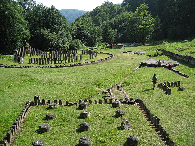
What Kingdom built these temple ruins?
Since you've passed, and no one has posted another, I have one.
This one might be a little tricky.
What Kingdom built these temple ruins?
reply to post by isyeye
Could you give us a generalized geographical area? or another clue?
ETA: On a whim I'm guessing it's either Eastern European or Chinese... It looks like those trees in the back ground are coniferous or deciduous. so that narrows it down to the more northern latitudes..
Could you give us a generalized geographical area? or another clue?
ETA: On a whim I'm guessing it's either Eastern European or Chinese... It looks like those trees in the back ground are coniferous or deciduous. so that narrows it down to the more northern latitudes..
edit on 2-5-2013 by kimish because: (no reason given)
new topics
-
Any one suspicious of fever promotions events, major investor Goldman Sachs card only.
The Gray Area: 1 hours ago -
God's Righteousness is Greater than Our Wrath
Religion, Faith, And Theology: 6 hours ago -
Electrical tricks for saving money
Education and Media: 9 hours ago -
VP's Secret Service agent brawls with other agents at Andrews
Mainstream News: 10 hours ago -
Sunak spinning the sickness figures
Other Current Events: 11 hours ago -
Nearly 70% Of Americans Want Talks To End War In Ukraine
Political Issues: 11 hours ago
top topics
-
VP's Secret Service agent brawls with other agents at Andrews
Mainstream News: 10 hours ago, 9 flags -
Cats Used as Live Bait to Train Ferocious Pitbulls in Illegal NYC Dogfighting
Social Issues and Civil Unrest: 14 hours ago, 8 flags -
Electrical tricks for saving money
Education and Media: 9 hours ago, 4 flags -
Nearly 70% Of Americans Want Talks To End War In Ukraine
Political Issues: 11 hours ago, 3 flags -
Sunak spinning the sickness figures
Other Current Events: 11 hours ago, 3 flags -
Late Night with the Devil - a really good unusual modern horror film.
Movies: 13 hours ago, 2 flags -
Any one suspicious of fever promotions events, major investor Goldman Sachs card only.
The Gray Area: 1 hours ago, 2 flags -
The Good News According to Jesus - Episode 1
Religion, Faith, And Theology: 16 hours ago, 1 flags -
God's Righteousness is Greater than Our Wrath
Religion, Faith, And Theology: 6 hours ago, 0 flags
active topics
-
Nearly 70% Of Americans Want Talks To End War In Ukraine
Political Issues • 20 • : FlyersFan -
-@TH3WH17ERABB17- -Q- ---TIME TO SHOW THE WORLD--- -Part- --44--
Dissecting Disinformation • 662 • : F2d5thCavv2 -
God's Righteousness is Greater than Our Wrath
Religion, Faith, And Theology • 12 • : randomuser2034 -
SETI chief says US has no evidence for alien technology. 'And we never have'
Aliens and UFOs • 61 • : andy06shake -
The Reality of the Laser
Military Projects • 47 • : F2d5thCavv2 -
Definitive 9.11 Pentagon EVIDENCE.
9/11 Conspiracies • 423 • : Lazy88 -
Election Year 2024 - Interesting Election-Related Tidbits as They Happen.
2024 Elections • 73 • : Threadbarer -
Sunak spinning the sickness figures
Other Current Events • 8 • : McUrnsalso -
HORRIBLE !! Russian Soldier Drinking Own Urine To Survive In Battle
World War Three • 36 • : TheMisguidedAngel -
British TV Presenter Refuses To Use Guest's Preferred Pronouns
Education and Media • 146 • : Consvoli