It looks like you're using an Ad Blocker.
Please white-list or disable AboveTopSecret.com in your ad-blocking tool.
Thank you.
Some features of ATS will be disabled while you continue to use an ad-blocker.

Satellite imaging and other evidence of a "Green Sahara" and an old Nile River
page: 1share:
Hello fellow ATS’ers. I decided to create this thread on the topic of the “Green Sahara” and the old Nile River since it seems to have garnered
very little attention. I am not sure how well known it is in the ATS community, or anywhere else for that matter, about the evidence surrounding the
Nile previously flowing from east to west through the Sahara Desert and emptying into the Atlantic Ocean. I have found only one other thread on the
Nile changing course HERE but it was more in the form of a question by the OP in
search of research or archeological surveys.
I thought I would throw in some sources and other reading material to enhance the subject for discussion.
First, I would like to explain briefly how I came upon this and why I became so interested. A few years ago when I was really getting into the Edgar Cayce material, I came across a few readings he had done concerning Egypt, the pyramids, the sphinx, and more specifically the Nile.
edgarcayce.org
At the time, those particular readings didn’t really catch much of my attention. Interesting yes, but it pretty much faded into the recesses of my mind. It wasn’t until later on I had read an article or maybe I had watched it somewhere (can’t remember), that satellite imaging had discovered previously unknown river valleys and lakes beneath the Sahara. This astounded me because it brought to mind the Nile readings Edgar Cayce had provided which was about a few decades before that was even discovered. Regardless of how some might feel about him, it is still quite perplexing.
Of course this is not entirely a Cayce thread, so moving on now.
livescience.com
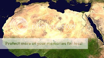
If you notice in the picture above, you can follow the dots quite clearly going through the Sahara towards the Atlantic.
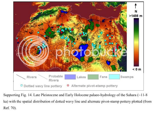
Evidence shows the Sahara was once a very fertile land which is dubbed the “Green Sahara”. It has been discovered that the Sahara went through a lot of changes over the ages but it was about 12,000 years ago that the rains and lakes of a fertile Sahara returned after the lakes had dried up during the last Ice Age. This continued except for a 1,000 year period that ended around 4,500 years ago.
It has been long known by geologists that the Sahara’s basins contain an abundance of mineral deposits of previous lakes and rivers. And if that wasn’t enough, findings of scattered human artifacts and bones from that time period have been discovered by various explorers over the years. As Dr. Sereno points out:
nytimes.com
The prehistoric Saharan rock paintings and engravings also “paint” a different picture of the Sahara.
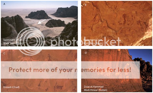
It is a veritable art museum of images depicting pastoral scenes abundant with elephants, giraffe, hippos, aurochs (a wild ancestor of domestic cattle), and antelope, occasionally being pursued by bands of hunters. Certainly not a depiction of the Sahara we see today but most likely what it once was.
I thought I would throw in some sources and other reading material to enhance the subject for discussion.
First, I would like to explain briefly how I came upon this and why I became so interested. A few years ago when I was really getting into the Edgar Cayce material, I came across a few readings he had done concerning Egypt, the pyramids, the sphinx, and more specifically the Nile.
“The Nile entered into the Atlantic Ocean. What is now the Sahara was an inhabited land and very fertile. (Reading #364-13)”
“In the one before this we find again in this same land now called Egypt (this before the mountains rose in the south, and when the waters called the Nile then emptied into what is NOW the Atlantic Ocean)… (Reading #276-2)”
“In those periods when the first change had come in the position of the land, when the Nile (or Nole, then) emptied into what is now the Atlantic Ocean, on the Congo end of the country. What is now as the Sahara was a fertile land. (Reading #5748-6)”
edgarcayce.org
At the time, those particular readings didn’t really catch much of my attention. Interesting yes, but it pretty much faded into the recesses of my mind. It wasn’t until later on I had read an article or maybe I had watched it somewhere (can’t remember), that satellite imaging had discovered previously unknown river valleys and lakes beneath the Sahara. This astounded me because it brought to mind the Nile readings Edgar Cayce had provided which was about a few decades before that was even discovered. Regardless of how some might feel about him, it is still quite perplexing.
Of course this is not entirely a Cayce thread, so moving on now.
livescience.com
If you notice in the picture above, you can follow the dots quite clearly going through the Sahara towards the Atlantic.
Evidence shows the Sahara was once a very fertile land which is dubbed the “Green Sahara”. It has been discovered that the Sahara went through a lot of changes over the ages but it was about 12,000 years ago that the rains and lakes of a fertile Sahara returned after the lakes had dried up during the last Ice Age. This continued except for a 1,000 year period that ended around 4,500 years ago.
It has been long known by geologists that the Sahara’s basins contain an abundance of mineral deposits of previous lakes and rivers. And if that wasn’t enough, findings of scattered human artifacts and bones from that time period have been discovered by various explorers over the years. As Dr. Sereno points out:
“Everywhere you turned, there were bones belonging to animals that don’t live in the desert,” he said. “I realized we were in the green Sahara.”
nytimes.com
The prehistoric Saharan rock paintings and engravings also “paint” a different picture of the Sahara.
It is a veritable art museum of images depicting pastoral scenes abundant with elephants, giraffe, hippos, aurochs (a wild ancestor of domestic cattle), and antelope, occasionally being pursued by bands of hunters. Certainly not a depiction of the Sahara we see today but most likely what it once was.
(Continued…)
Evidence suggests that the region has been drying up slowly starting from about 6,000 years ago into what we see today.
astrobio.net
(However, as you will see below, scientists are still debating whether or not the Sahara’s environmental change was rapid or gradual.)
Now what I had been wondering is what would cause the Sahara to dry up and the Nile to change course? Was it natural, man-made? Or perhaps a combination of both? Well, then I found this interesting tidbit of info.
nature.com
Also here: astrobio.net
Makes sense. That seems to be the best explanation so far based on the evidence for the many changes the Nile and the Sahara have gone through over the thousands and millions of years. So this brings me back to the Cayce readings concerning the Nile; was he spot on about the Nile once flowing from the east to the west and the Sahara being a very fertile land? It sure seems that way. Either that or he made a superbly educated guess before the tech was even available.
Another thing I thought about; could this drastic change in the environment have contributed to the fall of the Egyptian Old Kingdom and other seemingly abandoned ruins found throughout the desert? It appears climatic changes which effected the Nile had something to do with it.
Lost cities found beneath sands of the Sahara unexplained-mysteries.com
The Fall of the Egyptian Old Kingdom bbc.co.uk
Why Did a Great Egyptian Civilization Suddenly Collapse? ihr.org
Greening of Sahara Desert Triggered Early Human Migrations out of Africa sciencedaily.com
Well I hope you have enjoyed this thread on my personal research into the matter. I’m looking forward to seeing everyone’s responses and contributions on the subject.
I must say though, it still amazes me how the Edgar Cayce readings tends to motivate me into further research on various topics, especially into the scientific ones.
Here are a few more interesting pieces of info:
Construction Date of the Great Pyramid historysmysteries.org
Edgar Cayce and the Egyptian Book of the Dead edgarcayce.org
An Alternative Egyptian Mysteries and Science Directory ascendingpassage.com
Satellite imaging of Sahara Desert visions-of-earth.com
Egypt’s climate today climate-zone.com
Evidence suggests that the region has been drying up slowly starting from about 6,000 years ago into what we see today.
“The findings of this study are that the sedimentological and geochemical properties of the lake sediments confirm that the Sahara has been drying slowly from six thousand years ago to reach the present day conditions around 1,100 years ago.”
astrobio.net
(However, as you will see below, scientists are still debating whether or not the Sahara’s environmental change was rapid or gradual.)
Now what I had been wondering is what would cause the Sahara to dry up and the Nile to change course? Was it natural, man-made? Or perhaps a combination of both? Well, then I found this interesting tidbit of info.
“Paleoclimate and archaeological evidence tells us that, 11,000-5,000 years ago, the Earth's slow orbital 'wobble' transformed today's Sahara desert to a land covered with vegetation and lakes.”
nature.com
“A change in the Earth´s orbit, many scientists believe, transformed the "Green Sahara" into what is now the largest desert on the planet. While scientists are still trying to find out if the slow shift in orbit had rapid or gradual environmental consequences, they say Earth´s orbit will continue to change today and into the future.”
Also here: astrobio.net
Makes sense. That seems to be the best explanation so far based on the evidence for the many changes the Nile and the Sahara have gone through over the thousands and millions of years. So this brings me back to the Cayce readings concerning the Nile; was he spot on about the Nile once flowing from the east to the west and the Sahara being a very fertile land? It sure seems that way. Either that or he made a superbly educated guess before the tech was even available.
Another thing I thought about; could this drastic change in the environment have contributed to the fall of the Egyptian Old Kingdom and other seemingly abandoned ruins found throughout the desert? It appears climatic changes which effected the Nile had something to do with it.
Lost cities found beneath sands of the Sahara unexplained-mysteries.com
The Fall of the Egyptian Old Kingdom bbc.co.uk
Why Did a Great Egyptian Civilization Suddenly Collapse? ihr.org
Greening of Sahara Desert Triggered Early Human Migrations out of Africa sciencedaily.com
Well I hope you have enjoyed this thread on my personal research into the matter. I’m looking forward to seeing everyone’s responses and contributions on the subject.
I must say though, it still amazes me how the Edgar Cayce readings tends to motivate me into further research on various topics, especially into the scientific ones.
Here are a few more interesting pieces of info:
Construction Date of the Great Pyramid historysmysteries.org
Edgar Cayce and the Egyptian Book of the Dead edgarcayce.org
An Alternative Egyptian Mysteries and Science Directory ascendingpassage.com
Satellite imaging of Sahara Desert visions-of-earth.com
Egypt’s climate today climate-zone.com
edit on 10-4-2013 by Cherry0 because: (no reason given)
edit on 10-4-2013 by Cherry0 because: (no reason
given)
edit on 10-4-2013 by Cherry0 because: (no reason given)
reply to post by Cherry0
An extremely good thread, thank you. There is a great deal of water under the Sahara, an acquifer that emerges to the surface every 20,000 years or so (if I'm remembering correctly). I also got "into" Edgar Cayce for a few years, and read much of his material. That was a worthwhile use of time, as he may be the most credible and well-documented psychic of his era.
I recently obtained a couple artifact points from the Sahara region, very tiny bird points that when viewed with a magnifying glass look like minature perfect "arrowheads" of the most intricate design. The craftmanship of the region must have been quite advanced.
edit on 11-4-2013 by Aleister
because: (no reason given)
reply to post by Cherry0
Interesting read, thank you. I am long aware of the green Nile and also it changing its course. For example, even in Roman days what is now Tunisia and Libya was a prime area of agriculture for the Empire.
Regarding changing its course, this is something that all rivers do periodically (especially the "great" rivers). However, i am skeptical about the Nile flowing East to West. In actual fact, the Nile flows South to North and does so because the source (best guess as not fully established yet, believe it or not) is believed to be in Tanzania. What is entirely possible though is that there were other, long since dry, tributaries that flowed to the Atlantic.
Nice! I had not heard of this before. Very interesting that Cayce would say something like that as I am pretty sure he would have had absolutely no
knowledge of such a thing during his life. I would say the human artifacts and animal bones from non-desert creatures catches my thoughts the most.
It would be interesting to consider what kind of peoples lived around there, if they had a civilization, and how that would fit into the
'predeluvian' ancient history.
Excellent thread! I saw something similar to this on the Discovery Channel a long time ago.
The Great Sphynx has water erosion because when the Sphynx was built there was lush vegetation all around that area that is now almost completely barren.
I often tell people that the Nile once flowed into the Atlantic, I'm often met with strong criticism. Now I have a link to hold credence to that theory.
edit on 11-4-2013 by kimish because: change
Originally posted by Flavian
reply to post by Cherry0
Interesting read, thank you. I am long aware of the green Nile and also it changing its course. For example, even in Roman days what is now Tunisia and Libya was a prime area of agriculture for the Empire.
Regarding changing its course, this is something that all rivers do periodically (especially the "great" rivers). However, i am skeptical about the Nile flowing East to West. In actual fact, the Nile flows South to North and does so because the source (best guess as not fully established yet, believe it or not) is believed to be in Tanzania. What is entirely possible though is that there were other, long since dry, tributaries that flowed to the Atlantic.
Thanks for the reply Flavian. I also agree of the possibility that tributaries flowed westward into the Atlantic. I do know that currently the Nile flows north from the south. But I also find it possible it could have had a different course and flow, possibly due to the wobble and tilt of the earth at that time. However, even if the Nile did not flow westward into the Atlantic, the possibility of other rivers flowing that way is quite intriguing nonetheless.
Originally posted by Aleister
reply to post by Cherry0
An extremely good thread, thank you. There is a great deal of water under the Sahara, an acquifer that emerges to the surface every 20,000 years or so (if I'm remembering correctly). I also got "into" Edgar Cayce for a few years, and read much of his material. That was a worthwhile use of time, as he may be the most credible and well-documented psychic of his era.
I recently obtained a couple artifact points from the Sahara region, very tiny bird points that when viewed with a magnifying glass look like minature perfect "arrowheads" of the most intricate design. The craftmanship of the region must have been quite advanced.edit on 11-4-2013 by Aleister because: (no reason given)
Hello there Aleister. Sounds like a great collection! And the craftmanship does sound amazing. If you ever felt so inclined, I would love to see any pics.
Imagine what else can be found under all that sand. I know ancient ruins/cities have been found via satellite and satellite imaging.
Originally posted by kimish
Excellent thread! I saw something similar to this on the Discovery Channel a long time ago.
The Great Sphynx has water erosion because when the Sphynx was built there was lush vegetation all around that area that is now almost completely barren.
I often tell people that the Nile once flowed into the Atlantic, I'm often met with strong criticism. Now I have a link to hold credence to that theory.edit on 11-4-2013 by kimish because: change
Hey thanks. You bring up great point. I too may have watched the same show because I remember a while back watching something about the Sphinx and how it has evidence of water erosion throughout its structure. So again, thank you for bringing this up.
In fact, here are a couple of sites that explain it more in depth for those interested:
Robert M. Schoch
The Age of the Sphinx?
Apparently it's just a theory but I find the evidence for it to be quite convincing.
It's a very interesting idea that I think can be explained easily, with evidence that can be seen in history but climate scientists do not give much
credence. Let me try to explain the theory of Earth complete crustal displacement. Fitst looking at the earth draw an imaginary line from Russia
through Europe through Egypt down to the Antarctic. Move the crust in one whole movement North say 200 miles. Now northern Russia is well inside the
arctic circle. Egypt would be at the proximate area of central Europe with its attendant climate. Antarctica would be approximately where South Africa
is at the momment. This would account for the Sahara being verdant land. Also thiswould be the evidence for the last iceage in Europe ie. the ice
sheets didn't move down into these areas the earths crust move as a whole up into the Arctic. The end of the iceage the crust slipped back to its
original position. Hence the Sahara further south with the attendant climate to turn it into a desert. Evidence for this:- flash frozen mammoths in
Siberia. Mammoths living in a temperant zone suddenly very quickly moved into the Arctic circle, frozen, then the crust moved back to where it was
which is the normal tundra. Maps that show Antarctica ice free then moved back to be frozen again. The scientists claiming the ice came down from the
Arctic then retreated back ending the iceage in Northern Europe. I firmly believe in this theory but only fringe scientists entertain it. This theory
would explain many,many inigmas about the globe. I hope this helps in you're understanding.. CRAY
Originally posted by Cherry0
Now what I had been wondering is what would cause the Sahara to dry up and the Nile to change course?
I think you may have been misled on the "Nile changing course" bit. It's always flowed from the south to the north. The lush area of the "green Sahara" was more like the veldts (which can and do have swampy areas) or the great Plains of North America.
“Paleoclimate and archaeological evidence tells us that, 11,000-5,000 years ago, the Earth's slow orbital 'wobble' transformed today's Sahara desert to a land covered with vegetation and lakes.”
nature.com
“A change in the Earth´s orbit, many scientists believe, transformed the "Green Sahara" into what is now the largest desert on the planet. While scientists are still trying to find out if the slow shift in orbit had rapid or gradual environmental consequences, they say Earth´s orbit will continue to change today and into the future.”
Also here: astrobio.net
Those are misleading when seen out of context. What it's saying is that the Earth's orbit does wobble slightly (the Milankovitch cycles) -- and this slight orbital change (that's been present ever since the Earth and Moon system formed) causes the Earth's temperature to change in rather predictable cycles.
So, in context, "as the Earth warmed up from the last Ice Age, the climate across the Sahara became warmer and wetter. After awhile, it got much warmer and the areas of warmth in the ocean and the currents combined to reduce the rain across this part of Africa. Then humans with goats moved in (goats graze plants down to the roots so that they don't regrow easily) and the land became more barren and the desert spread."
was he spot on about the Nile once flowing from the east to the west and the Sahara being a very fertile land? It sure seems that way. Either that or he made a superbly educated guess before the tech was even available.
No to the first, yes to the second -- and Egypt was well known in antiquity as the "breadbasket of the ancient world" -- they grew wealthy from trading the grain grown there. At one point, the wealth (in grain) of ancient Egypt was pretty common knowledge for anyone who had a decent education.
Another thing I thought about; could this drastic change in the environment have contributed to the fall of the Egyptian Old Kingdom and other seemingly abandoned ruins found throughout the desert? It appears climatic changes which effected the Nile had something to do with it.
The drought was kind of the "death blow" to the Old Kingdom, but the truth is that the leadership was in trouble before that. However, the drought which caused the Nile problems was not so much "lack of rainfall in the deserts of Egypt" but "several decades of very little rainfall in Nubia and the mountains" which meant that the Nile did not flood properly. In fact, the ancient Egyptians had "Nile meters" -- a flood of a certain height range meant prosperity. If the waters were too high or too low, that would spell disaster.
But it wasn't just the Nile. The position of ruler had become weak as provincial governors grew stronger (and decided that maybe THEY should be rulers of their own land and not have to pay tribute to or support a very distant king. So you had a political system that was falling apart, the rise of powerful local leaders, and starvation and drought.
The story of the desertification of North Africa really is interesting -- a very neat topic!
reply to post by Byrd
Well put. I'm always glad to see your input into these types of threads. Your information is valuable and appreciated.
Question: What exactly is the explanation for the ancient river bed that was flowing from East to West seen by satellite that starts at or near the present day Niles source? Isn't it possible that in fact the Nile or another river From the same source once flowed from East to West causing the rift or river bed that we see from satellite images that flow from East to West? After all, a cataclysm can redirect the course of a river or stream.
Take for example where I live. All streams from one area flow north towards Lake Erie, Other streams or rivers flow south, this is due to Glacial retention, or the glaciers melting and moulding the land with them as they move.
reply to post by kimish
It's possible that it wasn't the Nile itself being redirected, but could have been an branch of the Nile that dried up as the rains did and the desert spread.
It may even be possible that there was something like an earth quake that actually didn't change the course of the Nile, but did close off that branch even and helped with it drying up.
Originally posted by kimish
Question: What exactly is the explanation for the ancient river bed that was flowing from East to West seen by satellite that starts at or near the present day Niles source?
I'm going to be horribly dense, but I don't see any river that flows east to west (some small wadis, yes, but nothing major.) What am I missing?
Isn't it possible that in fact the Nile or another river From the same source once flowed from East to West causing the rift or river bed that we see from satellite images that flow from East to West? After all, a cataclysm can redirect the course of a river or stream.
I'm sleepy as the dickens -- just don't see a riverbed there or remains of a river. Rivers can change course, yes, but the Nile is surrounded by mountains at its source. (This is a lesson plan on the watershed of the Nile -- a rather nice one) The image is a bit tiny, so here's a link to a much larger version of the same image:
Notice that the source of the Nile is in sort of a "cup" area. To the West is mountains, to the East and South are even bigger mountains.
Mountain building is a slow process (unless you've got a volcano, OR a supervolcano field... but we'd have noticed that.) A typical mountain rises an inch or two a year. Very massive earthquakes can displace layers of rock by 20 feet or so, but the difference in elevation on the map is on the order of hundreds of feet. They also leave very visible evidence, and none of that is seen in the area.
At least, not what I'm looking at... but I'm very tired.
Take for example where I live. All streams from one area flow north towards Lake Erie, Other streams or rivers flow south, this is due to Glacial retention, or the glaciers melting and moulding the land with them as they move.
Right. Water always flows downhill.
So... I think I must be missing something here -- sorry -- but if you'll point it out, I'll be happy to discuss it.
Thanks so much for your contributions so far everyone. Love where this is going. It's so nice to see a thread with a healthy civilized discussion
instead of insults and such. Stars all around!
Byrd, thanks for responding. Great points. This is something I am still learning about and I'm glad you stepped in and gave me more food for thought.
Byrd, thanks for responding. Great points. This is something I am still learning about and I'm glad you stepped in and gave me more food for thought.
edit on 12-4-2013 by Cherry0 because: (no reason given)
I remember when I was a kid, someone found a line of moored boats buried in the Sahara. They had obviously been tied up, rotted out and sank along the
river bank.
It was in a magazine like National Geographic.
It was in a magazine like National Geographic.
Note: They were not burial boats for the afterlife type thing.
Originally posted by thedeadtruth
I remember when I was a kid, someone found a line of moored boats buried in the Sahara. They had obviously been tied up, rotted out and sank along the river bank.
It was in a magazine like National Geographic.
Ah, very interesting indeed. Thanks.
I tried to look it up but didn't get very far. It would be interesting to know what type of boats they were and what they were used for.
reply to post by Cherry0
This is an interesting short piece about the work of Farouk El Baz which led to the tapping of a number of wells in the Sahara, the radar imagery of the former riverbeds is amazing, and as detailed, has been successfully used to access underground water repeatedly.
www.bbc.co.uk...
Another good documentary was one that covered the work of Sarah Parcak who has used satellite images to map Ancient Egypt...
en.wikipedia.org...
Unfortunately I cannot find a link to that, but what she found was that there were numerous signs of small settlement reaching out into the Sahara which over time had most likely been abandoned as activity became more and more clustered around the Nile. This indicates that the Sahara was once able to support small scale agriculture. Much like happened in China, with deruralisation, much of this land then suffered desertification due to not being maintained, although it probably began with the initial deforestation that is part of the neolithic mode of establishing argicultural settlements. Additionally, as we still see today, the urban sprawl often leads to smaller tributaries being blocked off or rerouted to make way for housing further increasing the dependency of those in outlying to move nearer to the major water source. All of which, combined, has a knock on effect in the creation of weather systems, thus diminishing rainfall, the removal of large bodies of trees being a pivotal factor in that respect, combined with the associated degradation of the mycorrhiza which helps transport nutrients and to 'bind' soil.
The current situation in Hungary provides a clear demonstration of this process in motion, that while the land can be maintained for many generations, will under certain climatic changes, find it hard to adapt to those changes, and result in the onset of desertification.
This is an interesting short piece about the work of Farouk El Baz which led to the tapping of a number of wells in the Sahara, the radar imagery of the former riverbeds is amazing, and as detailed, has been successfully used to access underground water repeatedly.
www.bbc.co.uk...
Another good documentary was one that covered the work of Sarah Parcak who has used satellite images to map Ancient Egypt...
From 2003 to 2004, Parcak used a combination of satellite imaging analysis and surface surveys in the possible detection of 132 archaeological sites, some dating back to 3,000 B.C.[3] In her latest work, Parcak tested several types of satellite imagery to look for water sources within the arid region of the Sinai, East Delta and Middle Egypt, determining possible archaeological sites.[3] According to Parcak this approach reduces the time and cost for determining archaeological sites compared to surface detection.[4]
In May 2011 the BBC aired a documentary, Egypt's Lost Cities, describing BBC sponsored research carried out by Parcak's UAB team for over a year using infra-red satellite imaging from commercial and NASA satellites.[5] The programme discussed the research and showed Parcak in Egypt looking for physical evidence. The UAB team announced that they had discovered 17 pyramids, more than 1,000 tombs and 3,000 ancient settlements outside Sa el-Hagar, Egypt.[6]
The release by the BBC of an announcement before the broadcast was criticised by the then Minister of State for Antiquities, Zahi Hawass. In a statement on his blog he wrote "I was very pleased to be involved with this project", but he criticized the announcement before the programme was broadcast, saying it had not yet been checked by his Ministry which is charged with approving any such announcements and pointed out inaccuracies in the article's content. Dr Hawass said "No one can say with certainty that the features displayed under the sand are actually pyramids".[7] The BBC sent a telegram to Hawass explaining that the announcement had not been approved or released by the BBC Satellite Project.[8]
en.wikipedia.org...
Unfortunately I cannot find a link to that, but what she found was that there were numerous signs of small settlement reaching out into the Sahara which over time had most likely been abandoned as activity became more and more clustered around the Nile. This indicates that the Sahara was once able to support small scale agriculture. Much like happened in China, with deruralisation, much of this land then suffered desertification due to not being maintained, although it probably began with the initial deforestation that is part of the neolithic mode of establishing argicultural settlements. Additionally, as we still see today, the urban sprawl often leads to smaller tributaries being blocked off or rerouted to make way for housing further increasing the dependency of those in outlying to move nearer to the major water source. All of which, combined, has a knock on effect in the creation of weather systems, thus diminishing rainfall, the removal of large bodies of trees being a pivotal factor in that respect, combined with the associated degradation of the mycorrhiza which helps transport nutrients and to 'bind' soil.
The current situation in Hungary provides a clear demonstration of this process in motion, that while the land can be maintained for many generations, will under certain climatic changes, find it hard to adapt to those changes, and result in the onset of desertification.
Rivers changing course can happen quickly or over a period of years. There are many examples throughout the "ancient" world. A simple example from
Egypt is the city of Pi-Rameses. Ruins from Pi-Ramesses were found in the 1930's in Tanis and it was then assumed that Tanis was the sight of the old
city.
However, subsequent analysis showed that Pi-Ramesses was located over 30km to the South at Qantir. Why had the Egyptians moved the capital city of Ramesses II over 30km? Basically because the river changed changed course leaving Pi-Ramesses high and dry.
This is a great example as it demonstrates that not only were the Egyptians capable of dealing with a changing climate, it also demonstrates their ability to move huge amounts of stonework, huge statues, etc, over desert to a holding city 30km to the north.
More modern examples - Yellow River and Mississippi River. In actual fact, it can also play havoc with modern international borders.
Changing river course alters Uganda - DR Congo border
new topics
-
Las Vegas UFO Spotting Teen Traumatized by Demon Creature in Backyard
Aliens and UFOs: 1 hours ago -
2024 Pigeon Forge Rod Run - On the Strip (Video made for you)
Automotive Discussion: 2 hours ago -
Gaza Terrorists Attack US Humanitarian Pier During Construction
Middle East Issues: 2 hours ago -
The functionality of boldening and italics is clunky and no post char limit warning?
ATS Freshman's Forum: 3 hours ago -
Meadows, Giuliani Among 11 Indicted in Arizona in Latest 2020 Election Subversion Case
Mainstream News: 4 hours ago -
Massachusetts Drag Queen Leads Young Kids in Free Palestine Chant
Social Issues and Civil Unrest: 4 hours ago -
Weinstein's conviction overturned
Mainstream News: 5 hours ago -
Supreme Court Oral Arguments 4.25.2024 - Are PRESIDENTS IMMUNE From Later Being Prosecuted.
Above Politics: 7 hours ago -
Krystalnacht on today's most elite Universities?
Social Issues and Civil Unrest: 7 hours ago -
Chris Christie Wishes Death Upon Trump and Ramaswamy
Politicians & People: 7 hours ago
top topics
-
Krystalnacht on today's most elite Universities?
Social Issues and Civil Unrest: 7 hours ago, 9 flags -
Weinstein's conviction overturned
Mainstream News: 5 hours ago, 6 flags -
University of Texas Instantly Shuts Down Anti Israel Protests
Education and Media: 10 hours ago, 6 flags -
Supreme Court Oral Arguments 4.25.2024 - Are PRESIDENTS IMMUNE From Later Being Prosecuted.
Above Politics: 7 hours ago, 5 flags -
Massachusetts Drag Queen Leads Young Kids in Free Palestine Chant
Social Issues and Civil Unrest: 4 hours ago, 4 flags -
Meadows, Giuliani Among 11 Indicted in Arizona in Latest 2020 Election Subversion Case
Mainstream News: 4 hours ago, 4 flags -
Chris Christie Wishes Death Upon Trump and Ramaswamy
Politicians & People: 7 hours ago, 2 flags -
Any one suspicious of fever promotions events, major investor Goldman Sachs card only.
The Gray Area: 12 hours ago, 2 flags -
Gaza Terrorists Attack US Humanitarian Pier During Construction
Middle East Issues: 2 hours ago, 2 flags -
2024 Pigeon Forge Rod Run - On the Strip (Video made for you)
Automotive Discussion: 2 hours ago, 1 flags
active topics
-
Cats Used as Live Bait to Train Ferocious Pitbulls in Illegal NYC Dogfighting
Social Issues and Civil Unrest • 22 • : NoviceStoic4 -
Supreme Court Oral Arguments 4.25.2024 - Are PRESIDENTS IMMUNE From Later Being Prosecuted.
Above Politics • 64 • : matafuchs -
Sunak spinning the sickness figures
Other Current Events • 22 • : angelchemuel -
Massachusetts Drag Queen Leads Young Kids in Free Palestine Chant
Social Issues and Civil Unrest • 10 • : Cre8chaos79 -
Nearly 70% Of Americans Want Talks To End War In Ukraine
Political Issues • 93 • : Xtrozero -
University of Texas Instantly Shuts Down Anti Israel Protests
Education and Media • 194 • : Irishhaf -
Fossils in Greece Suggest Human Ancestors Evolved in Europe, Not Africa
Origins and Creationism • 88 • : Xtrozero -
Gaza Terrorists Attack US Humanitarian Pier During Construction
Middle East Issues • 20 • : Justsomeboreddude3 -
Thousands Of Young Ukrainian Men Trying To Flee The Country To Avoid Conscription And The War
Other Current Events • 141 • : Consvoli -
Terrifying Encounters With The Black Eyed Kids
Paranormal Studies • 77 • : burritocat