It looks like you're using an Ad Blocker.
Please white-list or disable AboveTopSecret.com in your ad-blocking tool.
Thank you.
Some features of ATS will be disabled while you continue to use an ad-blocker.

Natural Formations vs. Artificial Structures: Strange Geometry at Glenelg (Curiosity/MSL)
page: 1share:
Here comes the next load of a sheer endless supply of "intriguing surface features at Glenelg" including some thoughts and indications as to
whether all this is just natural or perhaps something else!
I still remember when sometime between Sol 60 and 70 my opinion about Curiosity's images changed from "Ah, very interesting & beautiful" to something like "OMG? Is this Mars or somekind of interplanetary junkyard?" Some people would probably reply:
Well, OK. There may be beautiful and weird ventifacts out there. And perhaps all those rocks are really all natural, with nothing artificial inbetween them. But I'd prefer to have a second and closer look at all this (as opposed to NASA/JPL, I suppose) before deciding whether or not something might be natural or not. And one way to get a better picture of the situation is (probably) to look at the geometry of some of the surface features. Not for finding the ultimate proof or evidence, but for getting one more piece of the puzzle in place. Or to have yet another 'indicator' that could help answer the intriguing question whether we would really be the first ones on Mars.
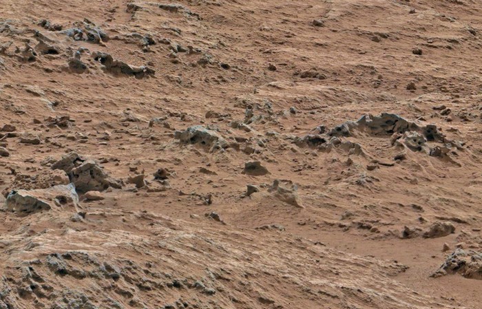
Based on my previous post (see here), I again looked at the images of the Sol 107 mastcam archive that roughly covers the area between POINT LAKE and SHALER (and to the east of that line). This time, I focused on a section that lies a bit further north, but still in close proximity to the features of my previous post (just a few feet away).
-----
*Please note that some of the images below have been white-balanced, contrast-enhanced and slightly sharpened. The original source images, however, are linked beneath the cross-eye 3D image set (further below, Mastcam 100) for direct comparisons with the NASA/JPL footage.
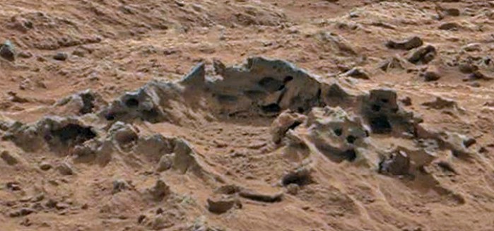
And here goes an overview of the area in question:
 Click here for the full screen version of the above
image.
Click here for the full screen version of the above
image.
Source: MSL Mastcam Archive for Sol 107
Click here for the link on Gigapan. Credit goes to impaired, thanks again for creating it!
And here is a 3D anaglyph version of the same area (for those who have Red/Cyan 3D glasses).
-------------
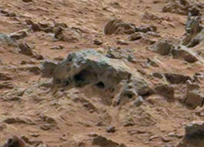
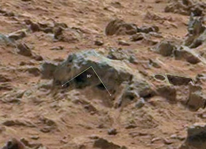
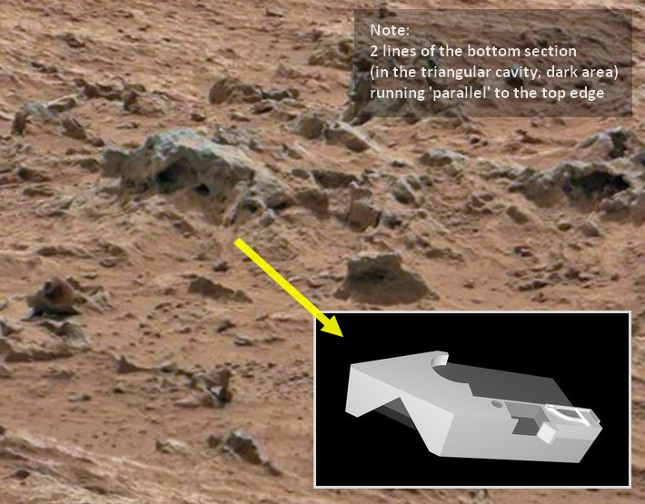
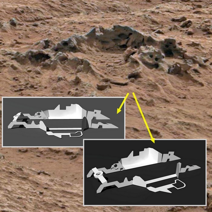
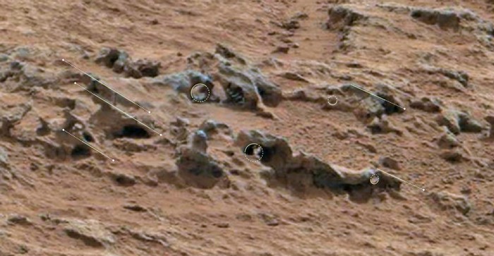
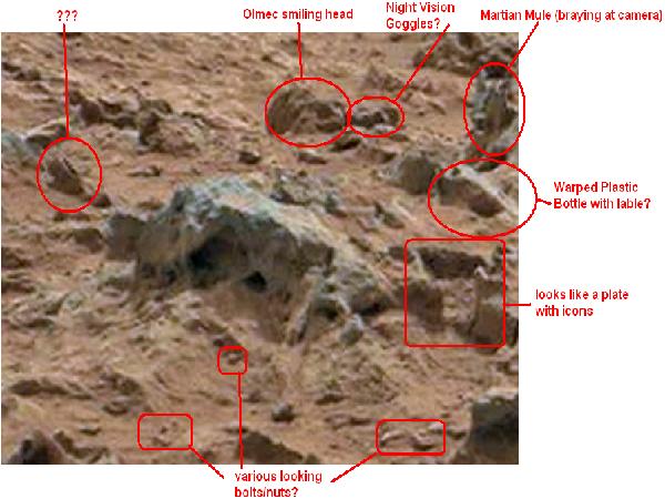
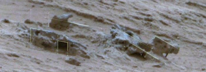
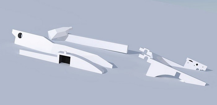
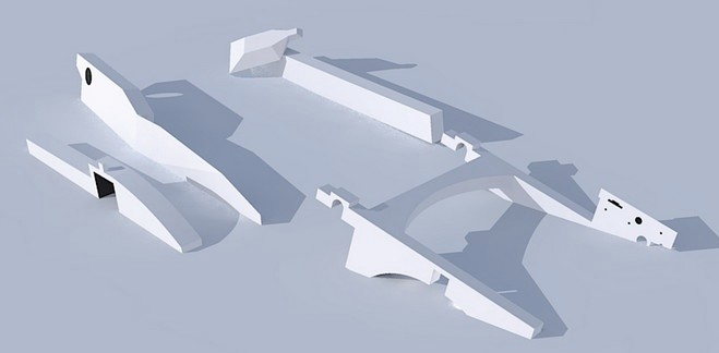
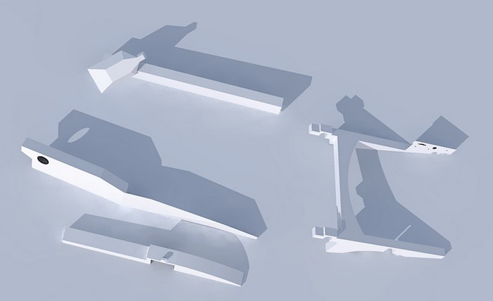
From the overview image above, I selected a few features that I found interesting and unusual enough in order to present them in this thread (including some annotations). I highlighted some of the more intriguing geometrical features using an overlay, whereas 'solid lines' represent edges that can actually be seen and 'dotted lines' are just for additional guidance. I included two clay-renderings, which are just abstract illustrations - freely interpreted - in order to translate the possible geometrical shapes into a scenery that's somewhat less rocky and dusty ...
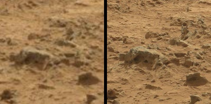
Feature 1 (right at the center of the overview image):
----------------------------------------------------------------
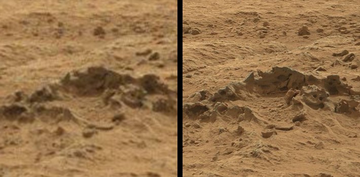
Feature 2 (slightly to the right of the center in the overview):
----------------------------------------------------------------
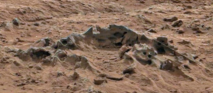
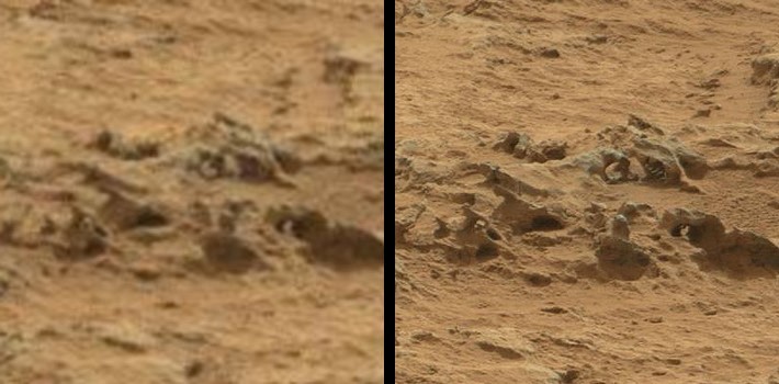
Feature 3 (top left in the overview image):
----------------------------------------------------------------
----------------------------------------------------------------
And here go the cross-eye 3D versions of the features highlighted above. I used the MastCam 34 (left) and MastCam 100 (right) images for the stereo effect.
Quick tutorial for viewing cross-eye 3D images without 3D glasses:
- look at the center of the two images (the black line in each image set)
- slowly move your eyes inwards until you see a third image appearing in the middle
- focus either with eyes or by increasing/reducing distance from screen, until it's sharp
Feature 1:
Feature 2:
Feature 3:
Source Images for Features 1 & 2
Mastcam RIGHT (100mm)
Mastcam LEFT (34mm)
Source Images for Feature 3
Mastcam RIGHT (100mm)
Mastcam LEFT (34mm)
----------------------------------------------------------------
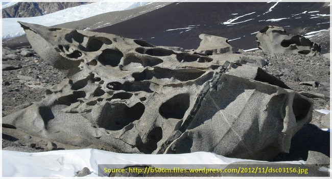
To conclude, I can say that I looked at many pictures of ventifacts on Earth and they can really take on weird shapes which sometimes even seem to resemble mechanical parts or machinery (a good example for that is McMurdo Valley in Antarctica, click here for a sample image). For that reason, I think it is important to really look twice or even more often in order to appreciate the subtle differences between those and what we see at Glenelg. In my view, the features display more than random wind erosion, the symmetry and geometry rather reminds me of intentional layouts with a functional purpose.
In case I'm proven wrong over time (eg. with new imagery of that area), I shall quietly retreat from my claims (which are - admittedly - quite a stretch for our imagination). But until then, I think we should not discard this interpretation as a possible explanation. Apart from that, I still wonder why Curiosity takes so many close-up images of nearly 'feature-less' rocks, while the visually intriguing formations we discuss here on ATS have apparently not been of any interest to the mission team.
Thanks a lot for reading up to this point and I'm very much looking forward to your thoughts on this!
----------
Previous threads & posts:
- Martian Ventifacts or Martian Artifacts? What's Your Take on This?
- Some more 'intriguing' MSL images that got me thinking
- Curiosity "Thought-Experiment" & Image Compilation
- Potential 'Artifacts' discussed in a Video
- Discussion of the Rocknest Panorama
- Strange Shipwreck-Like Feature
- Strange Rocks Post 1, Post 2 and Post 3
I still remember when sometime between Sol 60 and 70 my opinion about Curiosity's images changed from "Ah, very interesting & beautiful" to something like "OMG? Is this Mars or somekind of interplanetary junkyard?" Some people would probably reply:
"To the untrained eye ... Mars can indeed look like a very strange place!"
Well, OK. There may be beautiful and weird ventifacts out there. And perhaps all those rocks are really all natural, with nothing artificial inbetween them. But I'd prefer to have a second and closer look at all this (as opposed to NASA/JPL, I suppose) before deciding whether or not something might be natural or not. And one way to get a better picture of the situation is (probably) to look at the geometry of some of the surface features. Not for finding the ultimate proof or evidence, but for getting one more piece of the puzzle in place. Or to have yet another 'indicator' that could help answer the intriguing question whether we would really be the first ones on Mars.
Based on my previous post (see here), I again looked at the images of the Sol 107 mastcam archive that roughly covers the area between POINT LAKE and SHALER (and to the east of that line). This time, I focused on a section that lies a bit further north, but still in close proximity to the features of my previous post (just a few feet away).
-----
*Please note that some of the images below have been white-balanced, contrast-enhanced and slightly sharpened. The original source images, however, are linked beneath the cross-eye 3D image set (further below, Mastcam 100) for direct comparisons with the NASA/JPL footage.
And here goes an overview of the area in question:
Source: MSL Mastcam Archive for Sol 107
Click here for the link on Gigapan. Credit goes to impaired, thanks again for creating it!
And here is a 3D anaglyph version of the same area (for those who have Red/Cyan 3D glasses).
-------------
From the overview image above, I selected a few features that I found interesting and unusual enough in order to present them in this thread (including some annotations). I highlighted some of the more intriguing geometrical features using an overlay, whereas 'solid lines' represent edges that can actually be seen and 'dotted lines' are just for additional guidance. I included two clay-renderings, which are just abstract illustrations - freely interpreted - in order to translate the possible geometrical shapes into a scenery that's somewhat less rocky and dusty ...
Feature 1 (right at the center of the overview image):
----------------------------------------------------------------
Feature 2 (slightly to the right of the center in the overview):
----------------------------------------------------------------
Feature 3 (top left in the overview image):
----------------------------------------------------------------
----------------------------------------------------------------
And here go the cross-eye 3D versions of the features highlighted above. I used the MastCam 34 (left) and MastCam 100 (right) images for the stereo effect.
Quick tutorial for viewing cross-eye 3D images without 3D glasses:
- look at the center of the two images (the black line in each image set)
- slowly move your eyes inwards until you see a third image appearing in the middle
- focus either with eyes or by increasing/reducing distance from screen, until it's sharp
Feature 1:
Feature 2:
Feature 3:
Source Images for Features 1 & 2
Mastcam RIGHT (100mm)
Mastcam LEFT (34mm)
Source Images for Feature 3
Mastcam RIGHT (100mm)
Mastcam LEFT (34mm)
----------------------------------------------------------------
To conclude, I can say that I looked at many pictures of ventifacts on Earth and they can really take on weird shapes which sometimes even seem to resemble mechanical parts or machinery (a good example for that is McMurdo Valley in Antarctica, click here for a sample image). For that reason, I think it is important to really look twice or even more often in order to appreciate the subtle differences between those and what we see at Glenelg. In my view, the features display more than random wind erosion, the symmetry and geometry rather reminds me of intentional layouts with a functional purpose.
In case I'm proven wrong over time (eg. with new imagery of that area), I shall quietly retreat from my claims (which are - admittedly - quite a stretch for our imagination). But until then, I think we should not discard this interpretation as a possible explanation. Apart from that, I still wonder why Curiosity takes so many close-up images of nearly 'feature-less' rocks, while the visually intriguing formations we discuss here on ATS have apparently not been of any interest to the mission team.
Thanks a lot for reading up to this point and I'm very much looking forward to your thoughts on this!
----------
Previous threads & posts:
- Martian Ventifacts or Martian Artifacts? What's Your Take on This?
- Some more 'intriguing' MSL images that got me thinking
- Curiosity "Thought-Experiment" & Image Compilation
- Potential 'Artifacts' discussed in a Video
- Discussion of the Rocknest Panorama
- Strange Shipwreck-Like Feature
- Strange Rocks Post 1, Post 2 and Post 3
edit on 3-4-2013 by jeep3r because:
text
edit on 3-4-2013 by jeep3r because: spelling
edit on 3-4-2013 by jeep3r because: updated URLs

reply to post by jeep3r
Explanation: S&F!
I see ...
My apologies for having to resize and lessen the quality of the picture in order to post!
And to compare ...
Personal Disclosure: Weird indeed!
I hope this helps.
Explanation: S&F!
I see ...
My apologies for having to resize and lessen the quality of the picture in order to post!
And to compare ...
Personal Disclosure: Weird indeed!
I hope this helps.
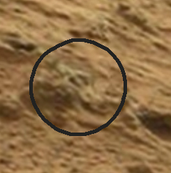
Don’t know about you OP but I find this ‘object’ very interesting.
img.abovetopsecret.com...
img.abovetopsecret.com...
Certainly doesn’t look natural to me, seems too angular and more importantly symetrical? but what do I know.
Smartie
img.abovetopsecret.com...
img.abovetopsecret.com...
Certainly doesn’t look natural to me, seems too angular and more importantly symetrical? but what do I know.
Smartie
reply to post by jeep3r
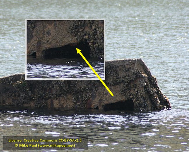
Well lets have a look at what water can do then!
Here is an image for Orkney of the north coast of Scotland.
What about crystals or rocks like these.
Nature can do curves & straight edges just because some on here can't understand doesn't mean it can't happen.
Well lets have a look at what water can do then!
Here is an image for Orkney of the north coast of Scotland.
this is the rocky shore around Orkney, showing the wave cut causeway at Birsay – see how the sandstone naturally splits to create blocks with nice right angles and diagonals – let nature do it for you!
What about crystals or rocks like these.
Nature can do curves & straight edges just because some on here can't understand doesn't mean it can't happen.
Although this is interesting, isn't it like inkblots per se? The mind tries to make sense of what it sees, like shapes in the clouds. Is it
possible that when you look hard enough to find meaning, you do indeed find it? I have seen a lot of images from mars having recognizable shapes, but
many of them just look like rocks to me...
reply to post by smartie
Explanation: Starred!
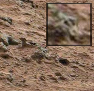
Looks like a broken Oscar award to me ...

Personal Disclosure: Or maybe I am just mistaking the object/oscar for a corkscrew?
Or even a broken sprinkler!
Explanation: Starred!
Looks like a broken Oscar award to me ...


Personal Disclosure: Or maybe I am just mistaking the object/oscar for a corkscrew?

Or even a broken sprinkler!

Originally posted by wmd_2008
reply to post by jeep3r
Well lets have a look at what water can do then!
Here is an image for Orkney of the north coast of Scotland.
Good find, wmd_2008! I clearly see triangular shapes and a lot of patterns & straight lines, a fascinating phenomenon! Also, I understand if you feel more comfortable on the side of the sceptical fraction here on ATS.
As a proponent of the non-natural fraction, however, I also see the differences between your interesting images and what can be seen at Glenelg. And I just wonder how these schemes could have been eroded away in such order and fashion. Would be nice to have a debate on this, perhaps also with other members who might know more about erosion than myself ...
reply to post by jeep3r
Well lets look at the problems with the images, first all these objects people like yourself see and think are unnatural tend to be in the distance/or smaller objects in the image then what tends to happen is the image is enlarged and blurs then detail is lost.
Then the imagination runs riot on what you think/hope to see and the rest is history, hundreds of threads with exactly the same problem.
Blurry over zoomed images often with the quote of being unnatural no way that could be formed it's artificial etc etc.
Nature can make all sorts of shapes that's why I don't jump to conclusions that and the fact that a lot of people that create these threads don't understand digital images I blame CSI on tv for that
Your critical view on this is welcome, wmd_2008!
That's what the 3D images are for. I recommend looking at the anaglyph version composed of Mastcam 34 & 100mm images. The additional depth helps to make out clear and distinct edges. In that way we can sort out things that lie in front or behind a formation.
Here, with Curiosity, it's different ... really!
The resolution of the imagery is fairly good. In fact, it's good enough to clearly make out the ventifacts or formations. If we factor in the amount of similar shapes (including their symmetry) that are scattered around in this particular area, I think we got more "indications" than in previous cases & missions.
That's true and you're absolutely right. Nature can produce strange formations that can fool you into believing something's there that - in fact - isn't. That's also why I'm not concluding anything as of yet. I'm just very much in favor of the non-natural interpretation of what we see ... I'd just like to encourage everybody to look more closely.
Apart from that, why is it, that these features (even if they are just natural ventifacts) are so boring that they are being ignored by the mission team? I mean, these things are rare on Earth, but imagine the excitement of finding ventifacts on Mars! But what did NASA/JPL do when they came across the prominent feature we coined 'Hugo' (image link)? They quickly published a paper explaining it as a ventifact (click here for the PDF press release).
And all the other interesting formations & ventifacts referenced in so many posts weren't even taken into account. Whereas it should be interesting to them. Let's not forget that Curiosity spent about 20 days/sols in the area between SHALER and POINT LAKE (directly where these formations are). Close-ups in even higher resolution would have been no problem at all. It's just as if NASA/JPL wanted to terminate any discussion by publishing the 'PDF on Ventifacts'. In this way, anything 'unusual' can be explained as a ventifact and that's what I find really disturbing.
Originally posted by wmd_2008
Well lets look at the problems with the images, first all these objects people like yourself see and think are unnatural tend to be in the distance/or smaller objects in the image then what tends to happen is the image is enlarged and blurs then detail is lost.
That's what the 3D images are for. I recommend looking at the anaglyph version composed of Mastcam 34 & 100mm images. The additional depth helps to make out clear and distinct edges. In that way we can sort out things that lie in front or behind a formation.
Then the imagination runs riot on what you think/hope to see and the rest is history, hundreds of threads with exactly the same problem. Blurry over zoomed images often with the quote of being unnatural no way that could be formed it's artificial etc etc.
Here, with Curiosity, it's different ... really!
The resolution of the imagery is fairly good. In fact, it's good enough to clearly make out the ventifacts or formations. If we factor in the amount of similar shapes (including their symmetry) that are scattered around in this particular area, I think we got more "indications" than in previous cases & missions.
Nature can make all sorts of shapes that's why I don't jump to conclusions that and the fact that a lot of people that create these threads don't understand digital images I blame CSI on tv for that
That's true and you're absolutely right. Nature can produce strange formations that can fool you into believing something's there that - in fact - isn't. That's also why I'm not concluding anything as of yet. I'm just very much in favor of the non-natural interpretation of what we see ... I'd just like to encourage everybody to look more closely.
Apart from that, why is it, that these features (even if they are just natural ventifacts) are so boring that they are being ignored by the mission team? I mean, these things are rare on Earth, but imagine the excitement of finding ventifacts on Mars! But what did NASA/JPL do when they came across the prominent feature we coined 'Hugo' (image link)? They quickly published a paper explaining it as a ventifact (click here for the PDF press release).
And all the other interesting formations & ventifacts referenced in so many posts weren't even taken into account. Whereas it should be interesting to them. Let's not forget that Curiosity spent about 20 days/sols in the area between SHALER and POINT LAKE (directly where these formations are). Close-ups in even higher resolution would have been no problem at all. It's just as if NASA/JPL wanted to terminate any discussion by publishing the 'PDF on Ventifacts'. In this way, anything 'unusual' can be explained as a ventifact and that's what I find really disturbing.
edit on 4-4-2013 by jeep3r because: updated URLs
I’m pretty sure the object I pointed out wasn’t the result of wind erosion, so can’t really said to be a ventifact.
As far as I know wind erosion doesn’t do symetrical erosion or shapes like the one I found?
As far as I know wind erosion doesn’t do symetrical erosion or shapes like the one I found?
edit on 5-4-2013 by smartie because: (no
reason given)
Originally posted by smartie
I’m pretty sure the object I pointed out wasn’t the result of wind erosion, so can’t really said to be a ventifact. As far as I know wind erosion doesn’t do symetrical erosion or shapes like the one I found?
Thanks for that, Smartie!
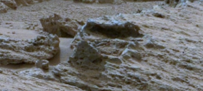
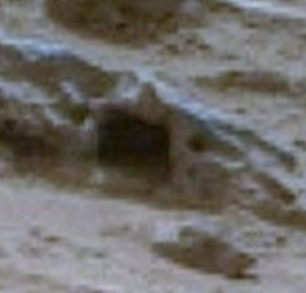
The above feature is one of those numerous oddities that you can find in that area. It certainly looks interesting, but you can also see that we need to enlarge the image in a way that real details are not clearly visible. And unfortunately, that 'rock' is too small to really get more details out of the 3D images available for that area. Yet, finds like these clearly make it more difficult to think of it all being just natural ...
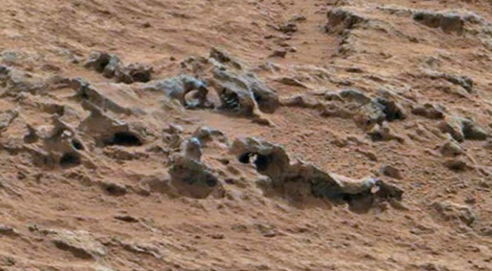
I tried to focus on features that are visible in a good resolution and which do not necessarily need to be enlarged too much:
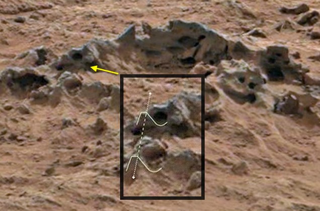
I find the above example particularily interesting because of the complex shape resembling both a triangle and a semi-circle. It's clearly visible on both sides of this formation (top & bottom) and I think this would be quite an accomplishment for a purely wind-eroded natural feature.
I also think that each one of those features (for itself) doesn't amount to anything, but in the combination with other, similar aspects found in the terrain - and when looking at the whole context of the area - this would make a non-natural interpretation less contradictory ...
edit on 5-4-2013 by jeep3r because: text
Originally posted by jeep3r
I tried to focus on features that are visible in a good resolution and which do not necessarily need to be enlarged too much:
I find the above example particularily interesting because of the complex shape resembling both a triangle and a semi-circle. It's clearly visible on both sides of this formation (top & bottom) and I think this would be quite an accomplishment for a purely wind-eroded natural feature.
I also think that each one of those features (for itself) doesn't amount to anything, but in the combination with other, similar aspects found in the terrain - and when looking at the whole context of the area - this would make a non-natural interpretation less contradictory ...
edit on 5-4-2013 by jeep3r because: text
Well at least you are more level headed about than most people that create this type of thread who said it's just wind erosion that caused it
But lets see
A Dreikanter is a type of ventifact that typically forms in desert or periglacial environments due to the abrasive action of blowing sand.[1] Dreikanters exhibit a characteristic three-faced pyramidal shape. The word Dreikanter is a German word meaning "three-edged
Curved surfaces & straight edges if that object was in any Mars image the usual suspects on here would create threads about it.
Originally posted by wmd_2008
Well at least you are more level headed about than most people that create this type of thread who said it's just wind erosion that caused it
Looks like we're getting straight to the point now! But irony aside, it seems to be a simple decision between two 'alternatives'.
Alternative 1: Ventifact (McMurdo Dry Valley, Antarctica)
Alternative 2: Chassis/Frame
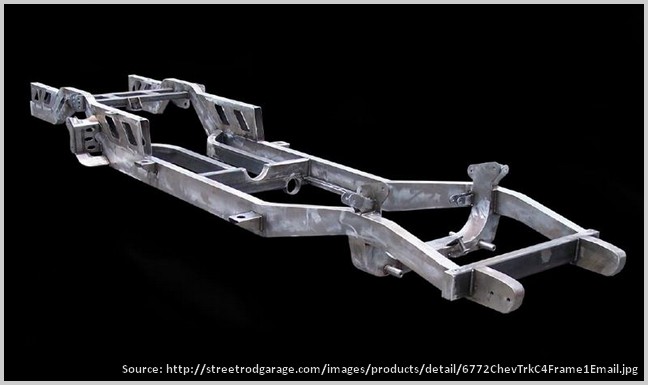
--> Choose your favorite interpretation!
__________
P.S.: Mods, the use of the images above is likely to qualify as fairuse, since they are strongly reduced in size while sources are indicated and the topic has overall informative character within a public discussion. If you prefer to have them removed, please let me know ...
edit on
5-4-2013 by jeep3r because: addition
Originally posted by wmd_2008
A Dreikanter is a type of ventifact that typically forms in desert or periglacial environments due to the abrasive action of blowing sand.[1] Dreikanters exhibit a characteristic three-faced pyramidal shape. The word Dreikanter is a German word meaning "three-edged
Curved surfaces & straight edges if that object was in any Mars image the usual suspects on here would create threads about it.
I guess there have indeed been threads about such rocks before on ATS, but it's noteworthy to mention that there have been other threads as well, where I think members identified formations that are generally difficult to explain ...
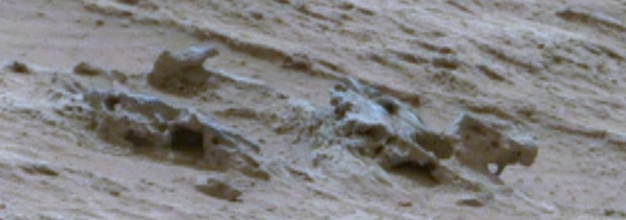
But let's again look at the following features from MSL/Sol 107:
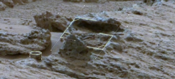

Do all these images above look completely normal to you?
At least to me it seems that there are quite a lot of parallel lines and right angles in a very small area. Further it seems that we're not looking at one solid body of rock, but rather at 'rock plates', thinner elements that - with their alignment and odd features - do seem to resemble something else ...
If it's a trick of nature and/or perspective (which we can almost rule out when looking at the 3D images), it would be a very good one and a more than strange coincidence that all that is lying there in such order and fashion.
edit on 6-4-2013 by jeep3r because: text
reply to post by jeep3r
You draw right angles because you think you see them well lets have a close look!
Lets look at one of your examples
Lets blow up the blurry image and crop it (which I hate doing to pictures with not a lot of detail)
Not right angles is it, the top of the opening is not a straight edge is it.
The images that are zoomed are not tack sharp that's the problem but you can see that your straight lines for the opening above are far from straight. The straight edge look to the sides could be due to contrast and zoom problems as you can probably see on the right side as you look at the picture.
The other problem is camera specs if the cameras have same size ccd's but different focal length lenses ...
.... then what they see/how it looks, is different, field of view/depth of field, magnification etc.
Now for example my camera has an APS-C size senor it's a 1.5 crop from full sensor,what does that mean well if if I have a 55-200mm zoom lens designed for a full size APC sensor on my camera it becomes an 82.5 -300mm zoom.
see image
Focal length can change perspective etc that's why sharp really sharp images are important the zoom zoom brigade on here go to far at times.
You draw right angles because you think you see them well lets have a close look!
Lets look at one of your examples
Lets blow up the blurry image and crop it (which I hate doing to pictures with not a lot of detail)
Not right angles is it, the top of the opening is not a straight edge is it.
The images that are zoomed are not tack sharp that's the problem but you can see that your straight lines for the opening above are far from straight. The straight edge look to the sides could be due to contrast and zoom problems as you can probably see on the right side as you look at the picture.
The other problem is camera specs if the cameras have same size ccd's but different focal length lenses ...
Cameras: Curiosity has seventeen cameras overall. 12 engineering cameras (Hazcams and Navcams) and five science cameras. MAHLI, MARDI, and MastCam cameras were developed by Malin Space Science Systems and they all share common design components, such as on-board electronic imaging processing boxes, 1600×1200 CCDs, and a RGB Bayer pattern filter.
Curiosity's fifth science camera, the remote micro-imager (RMI). The RMI provides black-and-white images at 1024×1024 resolution in a 0.02 radian (1.1-degree) field of view. This is approximately equivalent to a 1500 mm lens on a 35 mm camera.
.... then what they see/how it looks, is different, field of view/depth of field, magnification etc.
Now for example my camera has an APS-C size senor it's a 1.5 crop from full sensor,what does that mean well if if I have a 55-200mm zoom lens designed for a full size APC sensor on my camera it becomes an 82.5 -300mm zoom.
see image
Focal length can change perspective etc that's why sharp really sharp images are important the zoom zoom brigade on here go to far at times.
edit on 7-4-2013 by wmd_2008 because: (no reason given)
Originally posted by wmd_2008
reply to post by jeep3r
Lets blow up the blurry image and crop it (which I hate doing to pictures with not a lot of detail)
Not right angles is it, the top of the opening is not a straight edge is it.
The straight edge look to the sides could be due to contrast and zoom problems as you can probably see on the right side as you look at the picture.
In the context of what's there, they certainly look like right angles to me. Especially when taking into account the inclination of the objects in the terrain and the perspective/zoom-factor.
Technically, it's certainly debatable that zooming in and the blur of enlarging the image may cause the edges to look a bit more perfect than they might be. But I don't think it makes a big difference when looking at the whole arrangement of parts. And you are of course correct about the top-edge, which is not 100% straight.
However, it doesn't necessarily have to be a perfect top-edge in order to be potentially artificial. This can be seen in the example below:
For further orientation of how I see the formations lying in the terrain, I created another set of 3D views. I also did this in order to explain why the right angled square looks a bit 'distorted' in the original image.
Below the cropped close-up image, you'll see a corresponding 3D view from (approximately) the same perspective, then two renderings with a similar zoom factor but from a slightly elevated position and then from above:
That's how I think the different elements are (roughly) spread out on that slope, whereas I used a slightly different lighting. It more or less corresponds to the original when applying the same distance and perspective. It also shows that the parts are not perfectly symmetrical and that there seem to be at least two different sections (left and right) with different inclinations. All in all, it should be a fairly good representation of what's shown in the original photo.
The images that are zoomed are not tack sharp that's the problem but you can see that your straight lines for the opening above are far from straight.
I think the images are sharp enough to recognize geometric information, especially when combined with the 3D images generated from both mastcams. But you're right, they could be sharper and are not sufficient to draw any final conclusions. Yet, I would also prefer a second/different perspective for these features, just to make sure. But, unfortunately, it seems that NASA/JPL forgot to image them from a different angle
The other problem is camera specs if the cameras have same size ccd's but different focal length lenses.
That can indeed become a problem when cropping and zooming, no question. On the other hand, I do have some (limited) experience in photography and image editing, which hopefully helps me to interpret everything as accurately as possible. In order to eliminate potential mistakes, I also use the 3d images and sometimes 3d reproductions while checking different viewing angles, distances etc.
Focal length can change perspective etc that's why sharp really sharp images are important the zoom zoom brigade on here go to far at times.
I couldn't agree more with you! And I know that I'm going very far with my assumptions & interpretations.
Probably I'm just posting so much about these things, because I simply can't understand why Curiosity takes these amazing shots from a distance, drives past these formations and then provides super-sharp MAHLI/MastCam imagery of everything BUT these features.
But I'll better stop complaining now, otherwise they'll move this thread into the Rant Forum ...
edit on 8-4-2013 by jeep3r because: formatting
I personally think it's all still just rocks and shadows and holes in rocks on the surface. Under the surface? That could be a different story...
But I give you a star and flag for providing 3-D images (especially cross-eye ones! I didn't think of that, haha) and even 3-D rendering. That's good work, in my eyes - better than going into MS Paint and just drawing outlines over the rocks.
And ugggh - I hate that GigaPan panorama. It was the last one I ever did in Photoshop until I switched to PTGui. The projection is so crumby.
Sorry - had to get that out.
Originally posted by impaired
I personally think it's all still just rocks and shadows and holes in rocks on the surface. Under the surface? That could be a different story...
And ugggh - I hate that GigaPan panorama. It was the last one I ever did in Photoshop until I switched to PTGui. The projection is so crumby.
Sorry - had to get that out.
Thanks a lot, impaired!
As mentioned before, if it turns out that it's all just nicely aligned plates made of stone or salty crusts, then you'll find me sitting very ashamed somewhere in the corner!
In the meantime, I actually think the best indication we have (--> that we're looking at something special) is the lack of great pics of exactly those features, inspite of so much other stuff having been imaged by MSL. But hey, I'm not the geologist in the team, so I'd better be quiet I guess?!
Thanks again & keep up the good work!
reply to post by jeep3r
Well have a look at this image some eroded Basalt
Turn that on its side cover parts of it with wind blown sand photograph from a distance then zoom in , I see an almost circular , oval and square opening , there are also ridges as well.
Well have a look at this image some eroded Basalt
Turn that on its side cover parts of it with wind blown sand photograph from a distance then zoom in , I see an almost circular , oval and square opening , there are also ridges as well.
new topics
-
VP's Secret Service agent brawls with other agents at Andrews
Mainstream News: 48 minutes ago -
Sunak spinning the sickness figures
Other Current Events: 1 hours ago -
Nearly 70% Of Americans Want Talks To End War In Ukraine
Political Issues: 1 hours ago -
Late Night with the Devil - a really good unusual modern horror film.
Movies: 3 hours ago -
Cats Used as Live Bait to Train Ferocious Pitbulls in Illegal NYC Dogfighting
Social Issues and Civil Unrest: 4 hours ago -
The Good News According to Jesus - Episode 1
Religion, Faith, And Theology: 6 hours ago -
HORRIBLE !! Russian Soldier Drinking Own Urine To Survive In Battle
World War Three: 8 hours ago -
Bobiverse
Fantasy & Science Fiction: 11 hours ago -
Florida man's trip overseas ends in shock over $143,000 T-Mobile phone bill
Social Issues and Civil Unrest: 11 hours ago
top topics
-
Florida man's trip overseas ends in shock over $143,000 T-Mobile phone bill
Social Issues and Civil Unrest: 11 hours ago, 8 flags -
SETI chief says US has no evidence for alien technology. 'And we never have'
Aliens and UFOs: 15 hours ago, 7 flags -
Cats Used as Live Bait to Train Ferocious Pitbulls in Illegal NYC Dogfighting
Social Issues and Civil Unrest: 4 hours ago, 7 flags -
VP's Secret Service agent brawls with other agents at Andrews
Mainstream News: 48 minutes ago, 4 flags -
Former Labour minister Frank Field dies aged 81
People: 14 hours ago, 4 flags -
HORRIBLE !! Russian Soldier Drinking Own Urine To Survive In Battle
World War Three: 8 hours ago, 3 flags -
Bobiverse
Fantasy & Science Fiction: 11 hours ago, 3 flags -
Nearly 70% Of Americans Want Talks To End War In Ukraine
Political Issues: 1 hours ago, 3 flags -
Sunak spinning the sickness figures
Other Current Events: 1 hours ago, 3 flags -
Late Night with the Devil - a really good unusual modern horror film.
Movies: 3 hours ago, 2 flags
active topics
-
The Reality of the Laser
Military Projects • 42 • : Zaphod58 -
President BIDEN Vows to Make Americans Pay More Federal Taxes in 2025 - Political Suicide.
2024 Elections • 121 • : Zanti Misfit -
HORRIBLE !! Russian Soldier Drinking Own Urine To Survive In Battle
World War Three • 27 • : RickyD -
Nearly 70% Of Americans Want Talks To End War In Ukraine
Political Issues • 7 • : Consvoli -
Sunak spinning the sickness figures
Other Current Events • 1 • : Justoneman -
Mood Music Part VI
Music • 3100 • : TheDiscoKing -
VP's Secret Service agent brawls with other agents at Andrews
Mainstream News • 12 • : xuenchen -
Ditching physical money
History • 19 • : 20241105 -
Breaking Baltimore, ship brings down bridge, mass casualties
Other Current Events • 484 • : ThatSmellsStrange -
SETI chief says US has no evidence for alien technology. 'And we never have'
Aliens and UFOs • 39 • : SchrodingersRat