It looks like you're using an Ad Blocker.
Please white-list or disable AboveTopSecret.com in your ad-blocking tool.
Thank you.
Some features of ATS will be disabled while you continue to use an ad-blocker.

Ancient Maps That Shouldn't Exist
page: 1share:
Greetings, ATS!
Today I bring you an ancient mystery…..maps, drawn in antiquity, that show areas supposedly unknown and unexplored, such as the continent of Antarctica. How did the cartographers manage to accurately portray entire land masses that were unknown in their day and time? Could it be that these maps, often drawn based on even older knowledge, indicate that our ancestors knew more than we realized? Where did they come by such knowledge? You be the judge.
First up: The Piri Reis Map of 1513.
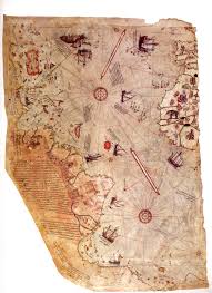
In 1929, a group of historians found an amazing map, drawn on a gazelle skin. The map, research showed, was drawn by Piri Reis, a famous Turkish Admiral and known cartographer. Reis, known for his passion for maps, had access to the Imperial Library of Constantinople. On the back of the map, Reis left notes indicating that he drew the map based on his research in the library, and used sources that dated back as far as the fourth century BCE or earlier.
So what makes the Piri Reis map so special?
Interesting, don’t you think?
Next up: The Orontius Finaeus Map of 1531
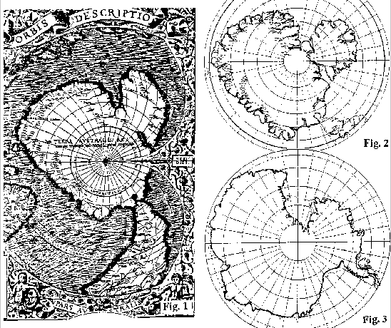
Discovered in the Library of Congress by Charles Hapgood in 1960, the Orontius Finaeus Map also shows an ice-free Antarctica. In fact, the map details flowing rivers, drainage patterns, a clean coastline, and mountain ranges only recently discovered. Some people claim the Orontius Finaeus Map to be the most accurate map of the area prior to the 1800s.
Who would have knowledge of the area in 4000 BC? In my understanding of world history (and admittedly I am a novice) the area was supposedly unexplored.
Moving along to our next enigma….The Bauche Map of 1737
Further Reading
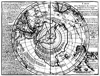
Phillip Bauche, a French geographer, drew a map of Antarctica. However, in Bauche’s map, Antarctica is drawn with two separate land masses and a clear shoreline. Because of this, Bauche’s map was considered to be erroneous.
How did Bauche know that Antarctica was actually two land masses? Could it have been an educated guess?
And finally….The Mercator Map of 1538
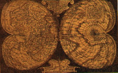
To appreciate why the Mercator Map of 1538 is such a marvel requires an understanding of the history of latitude and longitude and how they relate to sea navigation.
Latitude can be determined by using the stars or sun for observation. Longitude, however, is more difficult to calculate. You need the equation of “distance=speed X time” and an accurate clock to calculate longitude. In the 1500s, when Mercator drew his map, no such clocks existed. In fact, in the 1700s an actual Board of Longitude was established in England with the specific goal of determining longitude. In 1714, Sir Issac Newton declared that the main problem was that “a watch required for such accuracy has not yet been invented.” It wasn’t until 1761 that a clock (chronometer) was developed that could accurately assist in determining longitude.
How does this relate to the Mercator Map? Simple….the map, drawn in 1538, included accurate measurements of longitude.
As you can see, all of these maps pose some interesting questions about our known history. How did the cartographers manage to draw such accurate maps of areas supposedly unknown? Considering that the maps were the result of research from older sources, how was such knowledge obtained? Could it be that, somehow, an ancient civilization managed to map the world…..and that map managed to survive and be used by the mapmakers? If that is the case….what does that imply about the ancient civilization?
Hope you enjoy!
ETA: Additional OP source.
Today I bring you an ancient mystery…..maps, drawn in antiquity, that show areas supposedly unknown and unexplored, such as the continent of Antarctica. How did the cartographers manage to accurately portray entire land masses that were unknown in their day and time? Could it be that these maps, often drawn based on even older knowledge, indicate that our ancestors knew more than we realized? Where did they come by such knowledge? You be the judge.
First up: The Piri Reis Map of 1513.
In 1929, a group of historians found an amazing map, drawn on a gazelle skin. The map, research showed, was drawn by Piri Reis, a famous Turkish Admiral and known cartographer. Reis, known for his passion for maps, had access to the Imperial Library of Constantinople. On the back of the map, Reis left notes indicating that he drew the map based on his research in the library, and used sources that dated back as far as the fourth century BCE or earlier.
So what makes the Piri Reis map so special?
The Piri Reis map shows the western coast of Africa, the eastern coast of South America, and the northern coast of Antarctica. The northern coastline of Antarctica is perfectly detailed. The most puzzling however is not so much how Piri Reis managed to draw such an accurate map of the Antarctic region 300 years before it was discovered, but that the map shows the coastline under the ice. Geological evidence confirms that the latest date Queen Maud Land could have been charted in an ice-free state is 4000 BC.
Further and more accurate studies have proven that the last period of ice-free condition in the Antarctic ended about 6000 years ago. There are still doubts about the beginning of this ice-free period, which has been put by different researchers everything between year 13000 and 9000 BC.
The question is: Who mapped the Queen Maud Land of Antarctic 6000 years ago? Which unknown civilization had the technology or the need to do that?
It is well-known that the first civilization, according to the traditional history, developed in the mid-east around year 3000 BC, soon to be followed within a millennium by the Indus valley and the Chinese ones. So, accordingly, none of the known civilizations could have done such a job. Who was here 4000 years BC, being able to do things that NOW are possible with the modern technologies?
Interesting, don’t you think?
Next up: The Orontius Finaeus Map of 1531
Discovered in the Library of Congress by Charles Hapgood in 1960, the Orontius Finaeus Map also shows an ice-free Antarctica. In fact, the map details flowing rivers, drainage patterns, a clean coastline, and mountain ranges only recently discovered. Some people claim the Orontius Finaeus Map to be the most accurate map of the area prior to the 1800s.
Another tidbit of proof is the Ross sea. Today huge glaciers feed into it, making it a floating ice shelf hundreds of feet thick. Yet this map and the Reis map show estuaries and rivers at the site.
In 1949 coring was done to take samples of the ice and sediment at the bottom of the Ross Sea. They clearly showed several layers of stratification, meaning the area went through several environmental changes. Some of the sediments were of the type usually brought down to the sea by rivers. Tests done at the Carnegie Institute in Washington DC, which date radioactive elements found in sea water, dated the sediments at about 4000 BC, which would mean the area was ice free with flowing rivers up until that time - exactly what is recorded on the Reis and Finaeus maps.
Who would have knowledge of the area in 4000 BC? In my understanding of world history (and admittedly I am a novice) the area was supposedly unexplored.
Moving along to our next enigma….The Bauche Map of 1737
Further Reading
Phillip Bauche, a French geographer, drew a map of Antarctica. However, in Bauche’s map, Antarctica is drawn with two separate land masses and a clear shoreline. Because of this, Bauche’s map was considered to be erroneous.
Then in 1958 a seismic survey of Antarctica was carried out which surprisingly showed that Antarctica was indeed two archipelago islands covered by a thick layer of ice that made it appear as only one land mass and not only that, but that the general topography of the lands beneath the ice matches the drawings on the Bauche map in every detail. So how on earth this can be in any way possible? This map means that Bauche was in possession of a correct map showing Antarctica 100 years before it was discovered and not only that, but without any ice on it. Antarctica has not been in an ice free condition for a minimum of at least 10,000 years and many scientists believe that the period of time to be more like several million years
How did Bauche know that Antarctica was actually two land masses? Could it have been an educated guess?
And finally….The Mercator Map of 1538
To appreciate why the Mercator Map of 1538 is such a marvel requires an understanding of the history of latitude and longitude and how they relate to sea navigation.
Latitude can be determined by using the stars or sun for observation. Longitude, however, is more difficult to calculate. You need the equation of “distance=speed X time” and an accurate clock to calculate longitude. In the 1500s, when Mercator drew his map, no such clocks existed. In fact, in the 1700s an actual Board of Longitude was established in England with the specific goal of determining longitude. In 1714, Sir Issac Newton declared that the main problem was that “a watch required for such accuracy has not yet been invented.” It wasn’t until 1761 that a clock (chronometer) was developed that could accurately assist in determining longitude.
How does this relate to the Mercator Map? Simple….the map, drawn in 1538, included accurate measurements of longitude.
The Queen then offered a prize of 20,000 pounds to any man who might build such a device and finally, in 1761, a man by the name of Harrison claimed the prize and put forth his prototype chronometer which then "ushered in a new era of sea travel" for the world. During the 19th century maps then began being updated with the correct degrees of longitude. However Mercator’s map of 1538 was marked with correct longitude a full 223 years before it was discovered
As you can see, all of these maps pose some interesting questions about our known history. How did the cartographers manage to draw such accurate maps of areas supposedly unknown? Considering that the maps were the result of research from older sources, how was such knowledge obtained? Could it be that, somehow, an ancient civilization managed to map the world…..and that map managed to survive and be used by the mapmakers? If that is the case….what does that imply about the ancient civilization?
Hope you enjoy!
ETA: Additional OP source.
edit on 26/3/2013 by Sauron because: internal quote tags to external quote tags
edit on 3/27/13 by Hefficide because: (no
reason given)
Finally, a thread on ATS worthy of a star and flag.
Things like this have always puzzled me as well. My own personal take on it is there once was an advanced global civilization in antiquity that was destroyed by cataclysms that was just as advanced or even more so than modern day humans are. I think that there has been an ongoing conspiracy to suppress this knowledge about our past because this pattern of rise and fall has been repeated many times in the past and is about to happen again soon and "they" don't want people to know about it.
But thats just my two cents. Anyways, well put together thread as always smylee.
edit on 26-3-2013 by Cancerwarrior because: (no reason
given)
There is certainly some indication that some sea captains used maps that were derived from various older, "secret" or lost sources, you also have to
give them credit sometimes for just being lucky and guessing at the shapes of various undiscovered land sources because of the way currents ran. For
instance, even if you didn't know North America was ahead of you, you might guess there was something in the way that was turning the ocean current
from East-West to South-North.
Others might just be pure lucky guesses. You gotta fill an area of a map with something!
Others might just be pure lucky guesses. You gotta fill an area of a map with something!
There is so much missing in our history than we may ever know. There are clues to some but the majority is missing or twisted. I wonder how far back
we really go, and what events got us here. Maybe some day these questions may be answered, but we can only speculate. This is without doubt not the
first earth, But where are we in this line of time is anyone's guess with what we know as fact. S&F and may the search continue......
Great thread , thank You OP . While I do know most of the maps separate (most of them were covered on ATS here and there), it is nice to see a thread
that puts all of them together with the sole purpose to answer the question of how they were made. Since I do not have anything worth to add for now,
let me just flag and star this and keep an eye on how the discussion develops
S+F!
Excellent work.
There are some criticisms regarding these maps.
Should I manage the time to do so, I'll come back and edit to include such.
Thanks again for another excellent thread.
Excellent work.
There are some criticisms regarding these maps.
Should I manage the time to do so, I'll come back and edit to include such.
Thanks again for another excellent thread.
Is it at all suspicious that the Imperial Library of Constantinople was also destroyed by unintentional fires and deliberate acts of destruction?
This is why we can't have nice things!!
This is why we can't have nice things!!
reply to post by smyleegrl
I think it is quite obvious there were or even still may be advanced prehistory civilisations. There have been many threads about this concept here on ats.
I love this subject, thank you for posting it.
I think a mega thread about all the evidence in many differing fields should be made to highlight some of it and put into context.
For example, the giants, or nephilim, the construction of many ancient sites, we still I. Modern times with modern ewuipment still could not do at any price, the ancient maps, ancient stories describing advanced weapons and concepts, that didnt exist until modern times, by modern standards anyway. How so many ancient stductures have so uniform a construction, even though none of these civilisations could have interacted or shared ideas, how sites all across the world from the aforementioned civilisations appear to be aligned etc...
I believe the governments of the world are wuite aware of all of this, and may even have and hide the evidence for whatever reasons.
Just my thoughts.
I read about these when I was a kid in the early 80's in Charles Berlitze Bermuda triangle which was a best seller in it's time, it has always
fascinated me and given me tingle's down my spine.
Charles Hapgood's theory of earth crust displacement theory may have a few problem's such as the fact' that thermal plume's are responsible for Hawaii and Yosemity which sit over the plume's and if the crust had moved they would likely also have moved, the alternative then is a total physical axis displacement or just maybe the topography of the atlantic and pacific changed in such a way as to redirect warming ocean currents that may have helped keep it warm away from it, of course no one can disprove the spacemen theory so is remains as a possible answere as well, A true mystery.
Charles Hapgood's theory of earth crust displacement theory may have a few problem's such as the fact' that thermal plume's are responsible for Hawaii and Yosemity which sit over the plume's and if the crust had moved they would likely also have moved, the alternative then is a total physical axis displacement or just maybe the topography of the atlantic and pacific changed in such a way as to redirect warming ocean currents that may have helped keep it warm away from it, of course no one can disprove the spacemen theory so is remains as a possible answere as well, A true mystery.
reminds me of that quote,
"everything you know is wrong"
great thread smylee
"everything you know is wrong"
great thread smylee
Awesome Smylee.
As Slayer has said, "Our ancestors were anything but primitive." And I must agree. Many times archaeology has run into cases where the older finds are more advanced than newer finds. It puts a great big question mark on top of the idea of linear advancement of societies and civilizations. The understanding of things we take for granted today, were often understood by the oldest civilizations, but not the newer ones that came along after. So it seems sociological and technological advancement are not linear concepts as many in our world today like to think.
As Slayer has said, "Our ancestors were anything but primitive." And I must agree. Many times archaeology has run into cases where the older finds are more advanced than newer finds. It puts a great big question mark on top of the idea of linear advancement of societies and civilizations. The understanding of things we take for granted today, were often understood by the oldest civilizations, but not the newer ones that came along after. So it seems sociological and technological advancement are not linear concepts as many in our world today like to think.
reply to post by smyleegrl
G,day mate. Well done. you are on an interesting path keep searching. there are older maps out there, on stone if my memory serves me correctly. they show longitude and latitude. left me gobsmacked. try - ooparts as a starting point and dig on. goodluck.
G,day mate. Well done. you are on an interesting path keep searching. there are older maps out there, on stone if my memory serves me correctly. they show longitude and latitude. left me gobsmacked. try - ooparts as a starting point and dig on. goodluck.
reply to post by smyleegrl
I actually just began reading "Fingerprints of the Gods" by Graham Hancock. This is all discussed in the book, and I gotta say it blew me away!
I actually just began reading "Fingerprints of the Gods" by Graham Hancock. This is all discussed in the book, and I gotta say it blew me away!
Ancient Maps That Shouldn't Exist... according to mainstream science and history.
There ya go, amended the title for ya.
There ya go, amended the title for ya.
This subject was covered back in 2010.
www.abovetopsecret.com...
You might find some interesting information there to reiterate what you've said, or certainly add to it.
I believe there are some additional map examples in there.
Always good to see this subject covered again, though!
Keep up the good work.
www.abovetopsecret.com...
You might find some interesting information there to reiterate what you've said, or certainly add to it.
I believe there are some additional map examples in there.
Always good to see this subject covered again, though!
Keep up the good work.
reply to post by smyleegrl
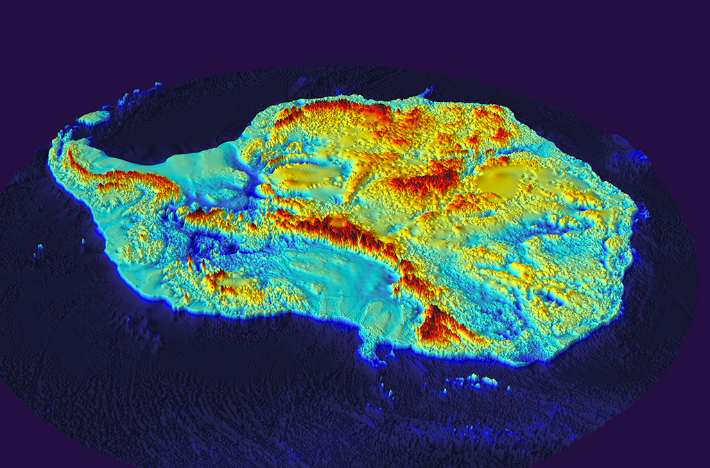
Just recently the British Antarctic Survey released a map of what Antarctica looks like without ice. Here's a photo:
Just recently the British Antarctic Survey released a map of what Antarctica looks like without ice. Here's a photo:

click thumbnail for larger image
www.antarctica.ac.uk...
edit on 3/26/2013 by this_is_who_we_are because: typo
S+f on this post. I'm still wondering how hard it is to find good relieable info on Antartica. Most amazing continent. I wonder what there is to find
underneath all the ice. Been studieing these maps the last hour. Thanks for this post!
reply to post by smyleegrl
S & F
Great collection and presentation. This was well worth the time to read and reply.
Good job.
S & F
Great collection and presentation. This was well worth the time to read and reply.
Good job.
reply to post by this_is_who_we_are
with more land exposed, there would be a large rift in the middle. It would basically be two islands.
with more land exposed, there would be a large rift in the middle. It would basically be two islands.
reply to post by smyleegrl
WOOHAHH!!
I don't have much to say but thank you for the compilation and that this is bookmarked for later mental intake as now is not the proper time but damn I love the idea of this thread...these "inconsistencies" have always bothered me and I am confident that the ancient humans were not as primitive as they are portrayed to be hence these maps so thank you so much
edit on 3/26/2013 by Corruption Exposed because: (no reason given)
new topics
-
African "Newcomers" Tell NYC They Don't Like the Free Food or Shelter They've Been Given
Social Issues and Civil Unrest: 21 minutes ago -
Russia Flooding
Other Current Events: 1 hours ago -
MULTIPLE SKYMASTER MESSAGES GOING OUT
World War Three: 2 hours ago -
Two Serious Crimes Committed by President JOE BIDEN that are Easy to Impeach Him For.
US Political Madness: 3 hours ago -
911 emergency lines are DOWN across multiple states
Breaking Alternative News: 3 hours ago -
Former NYT Reporter Attacks Scientists For Misleading Him Over COVID Lab-Leak Theory
Education and Media: 5 hours ago -
Why did Phizer team with nanobot maker
Medical Issues & Conspiracies: 5 hours ago -
Pro Hamas protesters at Columbia claim hit with chemical spray
World War Three: 5 hours ago -
Elites disapearing
Political Conspiracies: 8 hours ago -
A Personal Cigar UFO/UAP Video footage I have held onto and will release it here and now.
Aliens and UFOs: 8 hours ago
top topics
-
British TV Presenter Refuses To Use Guest's Preferred Pronouns
Education and Media: 15 hours ago, 17 flags -
Go Woke, Go Broke--Forbes Confirms Disney Has Lost Money On Star Wars
Movies: 10 hours ago, 13 flags -
Pro Hamas protesters at Columbia claim hit with chemical spray
World War Three: 5 hours ago, 11 flags -
Tucker Carlson interviews Christian pastor from Bethlehem.
Middle East Issues: 17 hours ago, 8 flags -
Freddie Mercury
Paranormal Studies: 10 hours ago, 7 flags -
Elites disapearing
Political Conspiracies: 8 hours ago, 7 flags -
A Personal Cigar UFO/UAP Video footage I have held onto and will release it here and now.
Aliens and UFOs: 8 hours ago, 5 flags -
Nirvana - Immigrant Song
Music: 14 hours ago, 5 flags -
Why did Phizer team with nanobot maker
Medical Issues & Conspiracies: 5 hours ago, 4 flags -
Two Serious Crimes Committed by President JOE BIDEN that are Easy to Impeach Him For.
US Political Madness: 3 hours ago, 3 flags
active topics
-
African "Newcomers" Tell NYC They Don't Like the Free Food or Shelter They've Been Given
Social Issues and Civil Unrest • 2 • : ToneD -
British TV Presenter Refuses To Use Guest's Preferred Pronouns
Education and Media • 49 • : ToneD -
Running Through Idiot Protestors Who Block The Road
Rant • 106 • : Terpene -
MULTIPLE SKYMASTER MESSAGES GOING OUT
World War Three • 12 • : Zaphod58 -
Elites disapearing
Political Conspiracies • 18 • : GENERAL EYES -
Echo & The Bunnymen - The Killing Moon!
Music • 11 • : Freeborn -
Mood Music Part VI
Music • 3049 • : boozo -
Are the 'Abrahamic Religions' all Really the Worshipping the Same Abrahamic God?
Conspiracies in Religions • 191 • : ToneD -
Go Woke, Go Broke--Forbes Confirms Disney Has Lost Money On Star Wars
Movies • 16 • : GotterDameron23 -
Pro Hamas protesters at Columbia claim hit with chemical spray
World War Three • 12 • : GENERAL EYES