It looks like you're using an Ad Blocker.
Please white-list or disable AboveTopSecret.com in your ad-blocking tool.
Thank you.
Some features of ATS will be disabled while you continue to use an ad-blocker.

Earthquake activity ramps up at El Hierro Volcano, Canary Islands
page: 2share:
reply to post by Lil Drummerboy
Mmmm, vino. But I don't wish doom upon anyone.
Honestly, my biggest concern with this episode at the moment is the stronger earthquakes. There have already been reports of small landslides from today's mag 4.1 and the 39 other quakes magnitude 3.0 and higher.
The landscape of the island is so steep, and the volcanic rock it is made of is crumbly--could spell major injuries or worse.
This link is to the AVCAN facebook page. It's in Spanish, but has good information, even through online translators.
edit on 3/25/2013 by Olivine because: (no reason given)
reply to post by Olivine
Understood,.
but the offer stands
been watching this area for a while,. seems to me just a minor hot zone,. close to the surface,.
and prone to surface outbreaks,. again no worries.. Nat geo,. was just lookin for commercial sales
Understood,.
but the offer stands
been watching this area for a while,. seems to me just a minor hot zone,. close to the surface,.
and prone to surface outbreaks,. again no worries.. Nat geo,. was just lookin for commercial sales
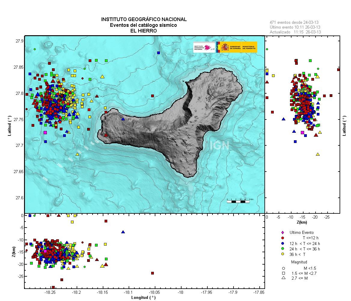
Here is the map showing earthquake locations near El Hierro over the past 3 days.
 (click image to enlarge)
IGN source page
That's 471 quakes, including this most recent mag 3.4.
It looks like there activity has slowed down a bit.
The VP of the Spanish Bar Association of Geologists says they cannot rule out stronger seismic activity, or a future eruption. He goes on to say that an eruption should not pose harm to the residents of the island because the activity is centered approximately 10-13 miles west of the island, and 1000 meters deep.
source of info above
 (click image to enlarge)
 IGN source page
That's 471 quakes, including this most recent mag 3.4.
It looks like there activity has slowed down a bit.
The VP of the Spanish Bar Association of Geologists says they cannot rule out stronger seismic activity, or a future eruption. He goes on to say that an eruption should not pose harm to the residents of the island because the activity is centered approximately 10-13 miles west of the island, and 1000 meters deep.
source of info above
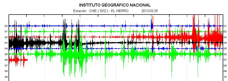
Earthquake activity at El Hierro has been fairly small in magnitude, but constant over the past day; that is until the past 90 minutes.
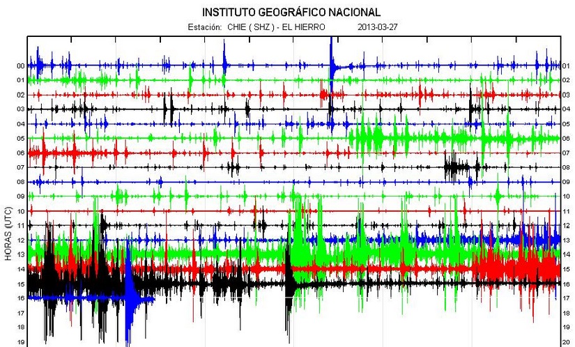
image source
Those 3 big ones on the black, 1500 line are reported by IGN to be magnitudes 4.3, 4.6, and 4.1--that is the largest yet. Those depths went from 18 to 19 to 12 kms deep.
I'm still waiting on the magnitude for the quake shown at 16:11 UTC. It looks big, too. These magnitudes creeping higher, coupled with the over 10 centimeters of vertical ground deformation on the western end of the island, could quickly lead to buildings being weakened or coming down. Luckily the hypocenters are still located offshore to the west, and not directly under the island.
ETA: That last quake was mag 4.4 at any even more shallow 10 kms depth.
I also wanted to repost some links--good info:
IGN El Hierro
earthquake-report (El Hierro page)
Erik Klemetti's blog post on El Hierro (always good info in the comments, too)
One more edit.
It looks like the IGN website server is overloaded at the moment. The links should work when traffic eases.
image source
Those 3 big ones on the black, 1500 line are reported by IGN to be magnitudes 4.3, 4.6, and 4.1--that is the largest yet. Those depths went from 18 to 19 to 12 kms deep.
I'm still waiting on the magnitude for the quake shown at 16:11 UTC. It looks big, too. These magnitudes creeping higher, coupled with the over 10 centimeters of vertical ground deformation on the western end of the island, could quickly lead to buildings being weakened or coming down. Luckily the hypocenters are still located offshore to the west, and not directly under the island.
ETA: That last quake was mag 4.4 at any even more shallow 10 kms depth.
Evento Fecha Hora(GMT)* Latitud Longitud Prof.(km) Int. Máx. Mag. Tipo Mag. (**) Localización
1201326 27/03/2013 16:10:55 27.7759 -18.2395 10 4.4 4 W FRONTERA.IH
I also wanted to repost some links--good info:
IGN El Hierro
earthquake-report (El Hierro page)
Erik Klemetti's blog post on El Hierro (always good info in the comments, too)
edit on 3/27/2013 by Olivine because: add a link
One more edit.
It looks like the IGN website server is overloaded at the moment. The links should work when traffic eases.
edit on 3/27/2013 by Olivine
because: (no reason given)
:waves hand:
Hey, I have a question!
I could most likely look this up and do research to find the answer, but I'm being a bit lazy, and I'm in the middle of catching up on laundry since it's my day off from work.
HOW do we know the depth of quakes? magnitude and finding the epicenter I understand just fine. It's the knowing the depth that I've never understood.
Can someone take pity on a astronomy guy who has his head stuck in the stars and stick it in the Earth for me and make me understand?
reply to post by eriktheawful
Depth is more difficult to pin down than triangulating the epicenter location. You can tell that a large earthquake is deep if the surface waves on the seismogram are fairly small in amplitude. But the way seismologists get precise depths is by measuring the difference in arrival times of primary waves (P-waves) and reflected primary waves (pP-waves).
I'll let USGS spell out the rest...
This image shows the pP-waves, which are fairly close to the hypocenter (or focus), the P-wave, and all the other myriad seismic waves. I hope this helps--unfortunately, I'm highly skilled at just muddying the waters.
image source
Depth is more difficult to pin down than triangulating the epicenter location. You can tell that a large earthquake is deep if the surface waves on the seismogram are fairly small in amplitude. But the way seismologists get precise depths is by measuring the difference in arrival times of primary waves (P-waves) and reflected primary waves (pP-waves).
I'll let USGS spell out the rest...
At distant seismograph stations, the pP follows the P wave by a time interval that changes slowly with distance but rapidly with depth. This time interval, pP-P (pP minus P), is used to compute depth-of-focus tables. Using the time difference of pP-P as read from the seismogram and the distance between the epicenter and the seismograph station, the depth of the earthquake can be determined from published travel-time curves or depth tables.
This image shows the pP-waves, which are fairly close to the hypocenter (or focus), the P-wave, and all the other myriad seismic waves. I hope this helps--unfortunately, I'm highly skilled at just muddying the waters.
image source
edit on 3/27/2013 by Olivine because: (no reason given)
reply to post by Olivine
True American is running at thread already..
www.abovetopsecret.com...
True American is running at thread already..
www.abovetopsecret.com...
edit on 27-3-2013 by rigel4 because: (no reason given)
reply to post by rigel4
Thanks rigel4.
TA's thread concerns a different Canary Island, La Palma, and possible harmonic tremor associated with the Cumbre Vieja volcano.
My thread is covering the earthquakes occurring toward the west end of El Hierro, which, as of yet, do not show any harmonic tremor, but are volcano related.
edit on 3/27/2013 by Olivine because: (no reason given)
Originally posted by Olivine
reply to post by rigel4
Thanks rigel4.
TA's thread concerns a different Canary Island, La Palma, and possible harmonic tremor associated with the Cumbre Vieja volcano.
My thread is covering the earthquakes occurring toward the west end of El Hierro, which, as of yet, do not show any harmonic tremor, but are volcano related.edit on 3/27/2013 by Olivine because: (no reason given)
Apologies , thought it was the same thing!
Hangs head in shame!
@rigel4-- No worries!
@eriktheawful-- Whew, good!
The earthquakes offshore El Hierro were smaller overnight, but picked up in intensity this morning. Clicking around the IGN site shows another mag 4.1 just 30 minutes ago. Luckily, the the quake action seems to be focused deeper; in the 18-21 kms range.
Armand @ earthquake-report explains that the total earthquake energy released in this recent swarm has already surpassed the entire 2011, into early 2012 event. That makes sense, since the magnitude scale is logarithmic, and we have already seen 7 eq's of mag 4+. I don't recall any that large from 2011/12.
The civil authority PEVOLCA has closed a few roadways on the western part of the island due to rockfall, and has raised the alert to 'Yellow'.
Most interesting (to me) is the GPS monitoring. It still shows a strong push to the East, but the rapid inflation has stopped for the time being. Since the hypocentral depths have moved back down, and the epicenters look to have moved South a bit, it's possible the magma is backfilling/forming a sill.
Take care.
ETA:
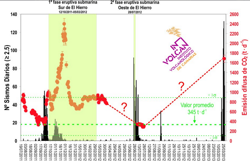
INVOLCAN (Volcanic Institute for the Canary Islands) has a really interesting graphic on their facebook page:
 (click to see full-size)
They state that the average emission of CO2 around El Hierro is 345 tons/day. Since this most recent volcano-tectonic earthquake swarm has begun, the levels have jumped up to 1684+/-72 tons/day. That's larger than when the submarine eruption was occurring off La Restinga.
They say that this level is more than is considered normal--- I'll say!
@eriktheawful-- Whew, good!
The earthquakes offshore El Hierro were smaller overnight, but picked up in intensity this morning. Clicking around the IGN site shows another mag 4.1 just 30 minutes ago. Luckily, the the quake action seems to be focused deeper; in the 18-21 kms range.
Armand @ earthquake-report explains that the total earthquake energy released in this recent swarm has already surpassed the entire 2011, into early 2012 event. That makes sense, since the magnitude scale is logarithmic, and we have already seen 7 eq's of mag 4+. I don't recall any that large from 2011/12.
The civil authority PEVOLCA has closed a few roadways on the western part of the island due to rockfall, and has raised the alert to 'Yellow'.
Most interesting (to me) is the GPS monitoring. It still shows a strong push to the East, but the rapid inflation has stopped for the time being. Since the hypocentral depths have moved back down, and the epicenters look to have moved South a bit, it's possible the magma is backfilling/forming a sill.
Take care.
edit on 3/28/2013 by Olivine because: spelling
ETA:
INVOLCAN (Volcanic Institute for the Canary Islands) has a really interesting graphic on their facebook page:
 (click to see full-size)
 They state that the average emission of CO2 around El Hierro is 345 tons/day. Since this most recent volcano-tectonic earthquake swarm has begun, the levels have jumped up to 1684+/-72 tons/day. That's larger than when the submarine eruption was occurring off La Restinga.
They say that this level is more than is considered normal--- I'll say!
edit on 3/28/2013 by Olivine because: add info
I don't want to come across as alarmist, but after thinking about this latest data concerning carbon dioxide emissions--I'm a little worried.
INVOLCAN states they take samples from many locations. I can't find the exact locations to see if they are sampling over the ocean or just on land.
CO2 contributes to explosive eruptions; just like when you shake a bottle of soda.
Since the earthquakes are focused some 17-21 kms deep, and offshore, that seems to indicate (to me, and I am not a geologist/volcanologist--just an avid watcher) a significant amount of gas. Enough that it can permeate upward through some 12 miles of rock. This coupled with the rapid GPS movement, is concerning.
If the earthquake depths rise toward the surface quickly, I would be evacuating. Of course, all of this activity could come to a full stop in the next hours or days--that's the way mother Earth works.
Let's keep our eyes on this...
reply to post by Olivine
That, means this:
So to me it means the data is incomplete, because they couldn't maintain it. But still, magmatic degassing seems to be in full swing, and interestingly, more so than the southern eruptive phases. Combined with the ground deformation you have already noted, and the seismic activity- yeah, looks like they are headed for another eruption. But until it happens, not committing. Volcanoes are notoriously unpredictable. I just hope this activity stays the HECK away from La Palma!
La no existencia de datos sobre este parámetro durante los periodos de tiempo enlazados por lineas discontinuas se debe a la carencia de recursos para haber mantenido una presencia permanente del INVOLCAN en El Hierro desde el pasado mes de abril de 2012.
That, means this:
The lack of data on this parameter during the time periods linked by broken lines is due to the lack of resources to have maintained a permanent presence Involcan in El Hierro since last April 2012.
So to me it means the data is incomplete, because they couldn't maintain it. But still, magmatic degassing seems to be in full swing, and interestingly, more so than the southern eruptive phases. Combined with the ground deformation you have already noted, and the seismic activity- yeah, looks like they are headed for another eruption. But until it happens, not committing. Volcanoes are notoriously unpredictable. I just hope this activity stays the HECK away from La Palma!
reply to post by TrueAmerican
Thanks for your input, TA--I really appreciate it.
Yeah, I guess it is good news that loads of gas are able to escape the magma, before it makes it closer to the surface. And I'm with you, staying away from La Palma would be great, considering the population is 8x that of El Hierro, and the unstable nature of the landscape.
reply to post by Olivine
Speaking of C02, you found anything on sulfur dioxide releases? Or is this just C02?
Even so, C02 in high enough concentrations can be lethal, especially if it concentrates near the ground due to low atmospheric temperature... Hope to God they are WATCHING that.
And it's ok if you are a little alarmist. In fact, you can be A LOT alarmist, and it doesn't bother me.
I did a bunch of 28 daily interactive maps of this current El Hierro series, in the same style as the Oct 2011 one, with a graph on the side of each
days map.
volcanictremor.wordpress.com...
the maps go backwards to 01/03/2013.
I had the zoom level at 11, but had to keep moving the island to the east because as time went on the earthquakes were heading further out west and off the map center point.
In the end I reset the zoom at 10 (further out) and applied that to all the maps in the series.
I'll update it over the weekend as things develop.
Here is a map of the whole lot interactive all mags, data from IGN
edit on 28-3-2013 by muzzy because: (no reason given)
reply to post by muzzy
Hey muzzy, I really like the maps broken down by day, and especially the graphs off to the side. It makes it a lot easier to see the ebb and flow in activity. Nice work.
Since I'm suffering a bit of insomnia, I thought I would check on the shaki ng in El Hierro. Strong activity over the past few hours...several more mag 4+ quakes.

More rockfalls and a short power outage on the western side of the island have also been reported here.
TrueAmerican, I have had no success finding any data other than the CO2 findings.
Hey muzzy, I really like the maps broken down by day, and especially the graphs off to the side. It makes it a lot easier to see the ebb and flow in activity. Nice work.
Since I'm suffering a bit of insomnia, I thought I would check on the shaki ng in El Hierro. Strong activity over the past few hours...several more mag 4+ quakes.
More rockfalls and a short power outage on the western side of the island have also been reported here.
TrueAmerican, I have had no success finding any data other than the CO2 findings.
So far the quake activity has gone up
Friday March 29 2013, 08:14:44 UTC Canary Islands, Spain Region 4.6
A 4.6 quake now seen.
quakes.globalincidentmap.com...
Friday March 29 2013, 08:40:53 UTC Canary Islands, Spain Region 3.7
Friday March 29 2013, 08:14:44 UTC Canary Islands, Spain Region 4.6
Friday March 29 2013, 07:58:04 UTC Canary Islands, Spain Region 4.3
Friday March 29 2013, 07:51:45 UTC Canary Islands, Spain Region 3.7
Friday March 29 2013, 07:31:48 UTC Canary Islands, Spain Region 3.0
Friday March 29 2013, 06:26:34 UTC Canary Islands, Spain Region 3.1
Friday March 29 2013, 05:55:03 UTC Canary Islands, Spain Region 3.5
Friday March 29 2013, 05:52:45 UTC Canary Islands, Spain Region 3.6
Friday March 29 2013, 05:45:26 UTC Canary Islands, Spain Region 3.6
Friday March 29 2013, 05:31:57 UTC Canary Islands, Spain Region 3.5
Friday March 29 2013, 05:26:49 UTC Canary Islands, Spain Region 3.3
Friday March 29 2013, 05:19:38 UTC Canary Islands, Spain Region 3.5
Friday March 29 2013, 05:07:37 UTC Canary Islands, Spain Region 3.0
Friday March 29 2013, 03:19:19 UTC Canary Islands, Spain Region 3.7
Friday March 29 2013, 03:17:22 UTC Canary Islands, Spain Region 3.0
Friday March 29 2013, 02:51:35 UTC Canary Islands, Spain Region 3.4
Friday March 29 2013, 02:48:17 UTC Canary Islands, Spain Region 3.4
Friday March 29 2013, 02:44:43 UTC Canary Islands, Spain Region 3.1
Friday March 29 2013, 02:40:08 UTC Canary Islands, Spain Region 3.0
Friday March 29 2013, 08:14:44 UTC Canary Islands, Spain Region 4.6
A 4.6 quake now seen.
quakes.globalincidentmap.com...
Friday March 29 2013, 08:40:53 UTC Canary Islands, Spain Region 3.7
Friday March 29 2013, 08:14:44 UTC Canary Islands, Spain Region 4.6
Friday March 29 2013, 07:58:04 UTC Canary Islands, Spain Region 4.3
Friday March 29 2013, 07:51:45 UTC Canary Islands, Spain Region 3.7
Friday March 29 2013, 07:31:48 UTC Canary Islands, Spain Region 3.0
Friday March 29 2013, 06:26:34 UTC Canary Islands, Spain Region 3.1
Friday March 29 2013, 05:55:03 UTC Canary Islands, Spain Region 3.5
Friday March 29 2013, 05:52:45 UTC Canary Islands, Spain Region 3.6
Friday March 29 2013, 05:45:26 UTC Canary Islands, Spain Region 3.6
Friday March 29 2013, 05:31:57 UTC Canary Islands, Spain Region 3.5
Friday March 29 2013, 05:26:49 UTC Canary Islands, Spain Region 3.3
Friday March 29 2013, 05:19:38 UTC Canary Islands, Spain Region 3.5
Friday March 29 2013, 05:07:37 UTC Canary Islands, Spain Region 3.0
Friday March 29 2013, 03:19:19 UTC Canary Islands, Spain Region 3.7
Friday March 29 2013, 03:17:22 UTC Canary Islands, Spain Region 3.0
Friday March 29 2013, 02:51:35 UTC Canary Islands, Spain Region 3.4
Friday March 29 2013, 02:48:17 UTC Canary Islands, Spain Region 3.4
Friday March 29 2013, 02:44:43 UTC Canary Islands, Spain Region 3.1
Friday March 29 2013, 02:40:08 UTC Canary Islands, Spain Region 3.0
edit on 7/30/2012 by dreamfox1 because: updates
reply to post by dreamfox1
It's quite busy today. The largest earthquakes were felt all the way up in La Palma.
There looks to be a lull in the action at the moment, but looking at the location maps, activity seems to be moving south.
Erik Klemetti has a nice summary blog post up at Wired.
About 30 minutes ago. The IGN site is slow/"service temporarily unavailable" at the moment, so I don't have an official magnitude, but it looks like it was closer to the island than most of the recent activity.
source
It's quite busy today. The largest earthquakes were felt all the way up in La Palma.
There looks to be a lull in the action at the moment, but looking at the location maps, activity seems to be moving south.
Erik Klemetti has a nice summary blog post up at Wired.
edit on 3/29/2013 by Olivine because: (no reason given)
About 30 minutes ago. The IGN site is slow/"service temporarily unavailable" at the moment, so I don't have an official magnitude, but it looks like it was closer to the island than most of the recent activity.
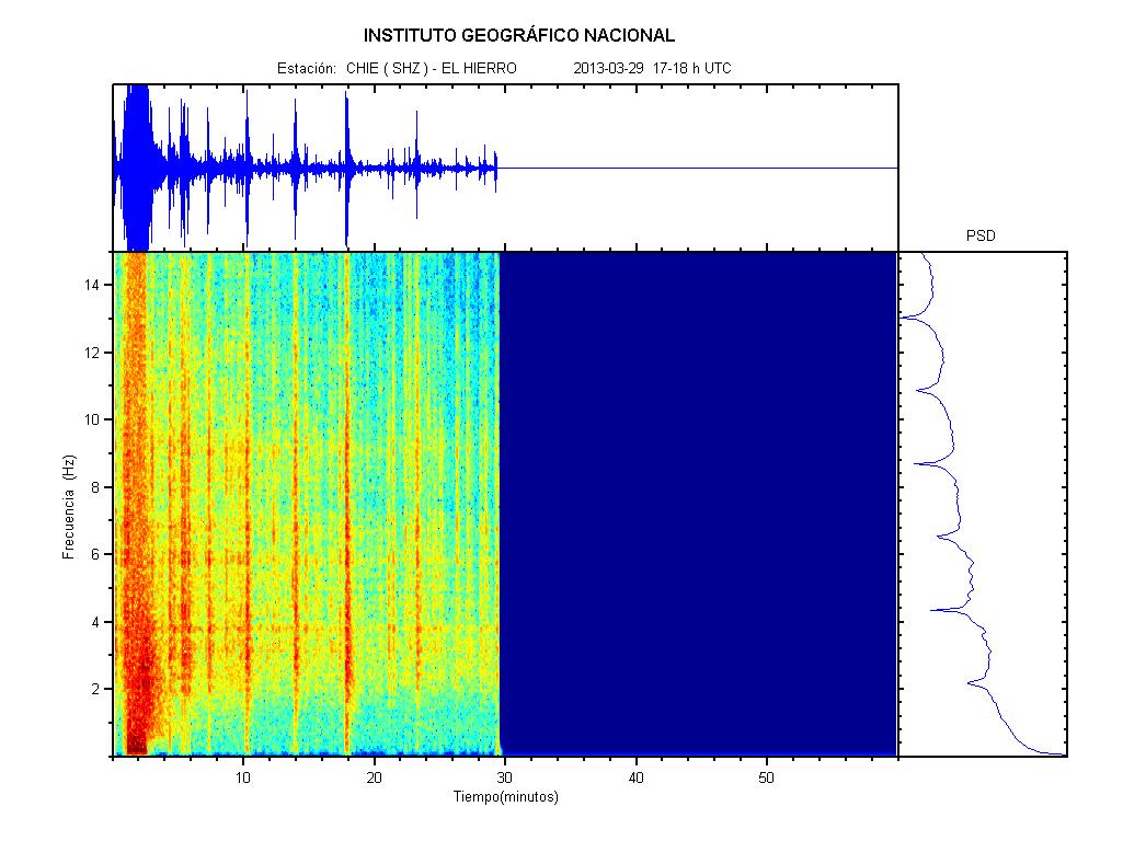
source
edit on 3/29/2013 by Olivine because: add info
Ugh, my edit time ran out.
This last big shake is reported asMag 4.5 Mag 4.6 by EMSC,
but only 5 kms 2 kms deep. Looking at the duration on the spectro in the post above, this may be revised higher.
IGN say it was a mag 4.7:
USGS have it at a Mag 4.6
Earthquake-Report has information from locals saying this was the most intense shaking to date, and more rockfall. Check out the pictures...
This last big shake is reported as
IGN say it was a mag 4.7:
Evento Fecha Hora(GMT)* Latitud Longitud Prof.
(km) Int. Máx. Mag. Tipo Mag. (**) Localización
1202124 29/03/2013 17:01:21 27.7309 -18.3148 20 Sentido 4.7 4 ATLÁNTICO-CANARIAS
USGS have it at a Mag 4.6
Earthquake-Report has information from locals saying this was the most intense shaking to date, and more rockfall. Check out the pictures...
edit on 3/29/2013 by Olivine because: (no reason given)
edit on 3/29/2013 by Olivine because: add info
new topics
-
The Good News According to Jesus - Episode 1
Religion, Faith, And Theology: 22 minutes ago -
HORRIBLE !! Russian Soldier Drinking Own Urine To Survive In Battle
World War Three: 2 hours ago -
Bobiverse
Fantasy & Science Fiction: 5 hours ago -
Florida man's trip overseas ends in shock over $143,000 T-Mobile phone bill
Social Issues and Civil Unrest: 5 hours ago -
Former Labour minister Frank Field dies aged 81
People: 7 hours ago -
SETI chief says US has no evidence for alien technology. 'And we never have'
Aliens and UFOs: 9 hours ago -
This is our Story
General Entertainment: 11 hours ago
top topics
-
President BIDEN Vows to Make Americans Pay More Federal Taxes in 2025 - Political Suicide.
2024 Elections: 14 hours ago, 16 flags -
SETI chief says US has no evidence for alien technology. 'And we never have'
Aliens and UFOs: 9 hours ago, 6 flags -
Florida man's trip overseas ends in shock over $143,000 T-Mobile phone bill
Social Issues and Civil Unrest: 5 hours ago, 6 flags -
Former Labour minister Frank Field dies aged 81
People: 7 hours ago, 4 flags -
Ode to Artemis
General Chit Chat: 15 hours ago, 3 flags -
This is our Story
General Entertainment: 11 hours ago, 3 flags -
Bobiverse
Fantasy & Science Fiction: 5 hours ago, 3 flags -
HORRIBLE !! Russian Soldier Drinking Own Urine To Survive In Battle
World War Three: 2 hours ago, 1 flags -
The Good News According to Jesus - Episode 1
Religion, Faith, And Theology: 22 minutes ago, 0 flags
active topics
-
Police clash with St George’s Day protesters at central London rally
Social Issues and Civil Unrest • 44 • : xWorldxGonexMadx -
Should Biden Replace Harris With AOC On the 2024 Democrat Ticket?
2024 Elections • 48 • : marg6043 -
"We're All Hamas" Heard at Columbia University Protests
Social Issues and Civil Unrest • 275 • : marg6043 -
HORRIBLE !! Russian Soldier Drinking Own Urine To Survive In Battle
World War Three • 11 • : JooTunnels -
The Good News According to Jesus - Episode 1
Religion, Faith, And Theology • 0 • : randomuser2034 -
Florida man's trip overseas ends in shock over $143,000 T-Mobile phone bill
Social Issues and Civil Unrest • 11 • : pianopraze -
Who are the Russians?
New World Order • 202 • : twistedpuppy -
1980s Arcade
General Chit Chat • 26 • : xWorldxGonexMadx -
SETI chief says US has no evidence for alien technology. 'And we never have'
Aliens and UFOs • 31 • : andy06shake -
President BIDEN Vows to Make Americans Pay More Federal Taxes in 2025 - Political Suicide.
2024 Elections • 69 • : underpass61