It looks like you're using an Ad Blocker.
Please white-list or disable AboveTopSecret.com in your ad-blocking tool.
Thank you.
Some features of ATS will be disabled while you continue to use an ad-blocker.

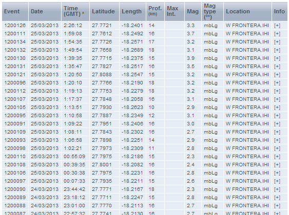
Earthquake activity ramps up at El Hierro Volcano, Canary Islands
page: 1share:
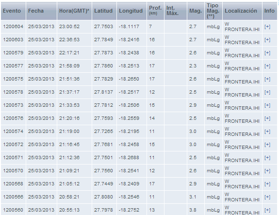
Over the past 2 hours, the earthquake activity at El Hierro has become noticeably stronger and nearly continuous.
 list source
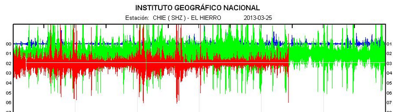
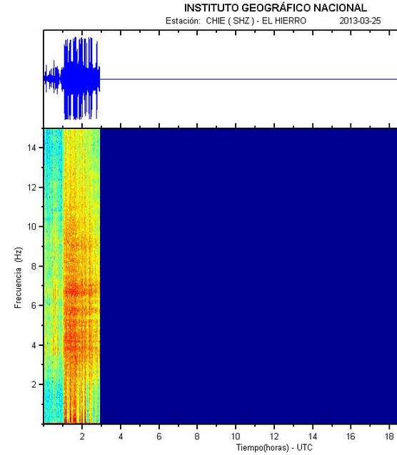
Here is a look of the past 2-1/2 hours on the webicorder:

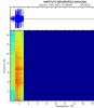
Here is the same data as a spectrogram:
The activity is still located just offshore the NW corner of the island. All of the above data can be found at the IGN El Hierro site.
Check out the islands deformation--a shift of over 4 centimeters to the east over the past week, when this volcano-tectonic activity renewed.
Earthquake-Report has excellent coverage of this situation.
They report INVOLCAN will be sending a team to measure CO2 tomorrow.
This activity bears watching, especially for the 10,000+ residents of the island and it's numerous tourists.
Here is a look of the past 2-1/2 hours on the webicorder:
Here is the same data as a spectrogram:
The activity is still located just offshore the NW corner of the island. All of the above data can be found at the IGN El Hierro site.
Check out the islands deformation--a shift of over 4 centimeters to the east over the past week, when this volcano-tectonic activity renewed.
Earthquake-Report has excellent coverage of this situation.
They report INVOLCAN will be sending a team to measure CO2 tomorrow.
This activity bears watching, especially for the 10,000+ residents of the island and it's numerous tourists.
edit on 3/24/2013 by Olivine because: refining
reply to post by Olivine
Is it me, or does that list show them rising in magnitude overall?
Forgive my ignorance on the subject, but I find it interesting.
Is it me, or does that list show them rising in magnitude overall?
Forgive my ignorance on the subject, but I find it interesting.
reply to post by eriktheawful
Hi Erik. Please, no apologies necessary.
Yes, the earthquakes have gotten larger in magnitude. When activity began to pick-up initially, back on the 17th/18th of March, most of the quakes were around mag 2.0. Over the past few days, there have been a handful of mag 3.0 quakes out of hundreds, but tonight they have definitely gotten stronger.
It's believed this seismic activity is magma moving at depth, which could eventually make its way to the seabed surface.
This is a very brief description of the island's volcanics.
El Hierro is a 278.5 km2 island, formed approx 1.2 million year ago[6] after three successive eruptions, the island emerged from the ocean as a triangle of basaltic dykes topped with a volcanic cone more than 2,000 metres high.[7] With continued activity resulting in the island expanding to have the largest number of volcanoes in the Canaries (over 500 cones, another 300 covered by more recent deposits), together with approximately 70 caves and volcanic galleries, including the Cueva de Don Justo whose collection of channels is over 6 km in length.[7] Landslides have reduced the size and height of the island.[7] The current highest point is situated in the middle of the island, in Malpaso, 1501 meters high.
reply to post by Olivine
September 15-17 2012 was the last time a major swarm of volcanic earthquakes hit El Hierro(December 31,2012 saw a small increase in quakes). Most of the quakes are to the North West of the island and it seems that a new undersea vent should be expected at the least.
September 15-17 2012 was the last time a major swarm of volcanic earthquakes hit El Hierro(December 31,2012 saw a small increase in quakes). Most of the quakes are to the North West of the island and it seems that a new undersea vent should be expected at the least.
Sounds good, another eruption possibly in the next year. Volcanoes are always erupting somewhere although it does seem like there are a few too many
recently.
I suggest you look at the placements of these earthquakes they are not normal!!!!!!
They are all at right angles to each other.
quakes.globalincidentmap.com...
Keep zooming in on the east coast of Africa and you will see what I am seeing.
I believe these are man-made as they must know Cumbre Vieja is next on the 188 day cycle which is due on
2nd April 2013.
Heads up on the East coast of USA, I think.
reply to post by AriesJedi
La Palma and El Hierro could be considered as twins.A land based eruption on El Hierro could be just as bad as one on La Palma.El Hierro seems to be the one to watch at the moment;I suspect we will see a new undersea vent(s) in the next 2-5 days.In the future we might even see a volcanic release similar to Krakatoa(it could be possible but hopefully we never have to find out if that is true or not).
La Palma and El Hierro could be considered as twins.A land based eruption on El Hierro could be just as bad as one on La Palma.El Hierro seems to be the one to watch at the moment;I suspect we will see a new undersea vent(s) in the next 2-5 days.In the future we might even see a volcanic release similar to Krakatoa(it could be possible but hopefully we never have to find out if that is true or not).
A Brazilian prophet named Jucelino Nobrega da Luz is saying that he is sure that a mega tsunami triggered by the Palma Canary Islands volcano will
happen in November of this year.
Jucelino's accuracy has been around 95%.
He has accurately predicted just about every major disaster of the last 15 years well before they occurred [9/11, challenger explosion, Tokyo Subway gas attacks, London terror bombings, etc.
(The below quote sounds very disjointed because it has been translated into English BTW)
Jucelino's accuracy has been around 95%.
He has accurately predicted just about every major disaster of the last 15 years well before they occurred [9/11, challenger explosion, Tokyo Subway gas attacks, London terror bombings, etc.
Jucelino Nobrega da Luz: A Modern Day Nostradamus?
* Princess Diana assassination (2 years before the accident)
* The first attack of World Trade Center (happened 3 & 1/2 years after the warning)
* The second attack of World Trade Center (911) (happened 13 years after the warning)
(predicted that two airplanes would hit the towers and that the buildings would fall)
* Tsunami in Asia (8 years before the disaster - predicted date & time within 1 hour)
* Air France Flight 447 Crash (3 years before the accident)
www.youtube.com...
* Michael Jackson Death (predicted date of death 3 years before)
* Saddam Hussein's hiding place - (provided his exact location 2 years before)
* Lindsay Hawker murder (predicted date of death 2 & 1/2 years before)
Jucelino Nobrega da Luz: A Modern Day Nostradamus
(The below quote sounds very disjointed because it has been translated into English BTW)
La Palma volcanic eruption on Canary Islands; could trigger up to 150-meter high tsunami across the Atlantic; American east coast including Florida devastated.
Models made by Jucelino the collapse of the island show the first regions to be affected by waves of up to 150 feet high: the neighboring islands of the Spanish archipelago of the Canaries. Within hours, the west coast of Africa will be hit by waves similar.
Between nine and 12 hours after the island collapses, waves of 20 to 80 meters will cross 6500 kilometers of ocean and reach the Caribbean islands and the east coast of the United States, Brazil and Canada. Upon arriving in ports and estuaries, the water will be piped to the interior. Deaths of people and destruction of property will be immense, according to Jucelino.
Up to 19 hours after the eruption, waves of 6 to 50 meters will reach the coast of North and Northeast Brazil, the Para Paraiba. The island of Fernando de Noronha is one of the places where the tsunami will come with more strength in the South Atlantic Europe will also be hit.
The southern coast of Portugal, Spain and West of Britain will experience waves of up to 20 meters, four or five hours after the geological event in the Canary Islands. Ports will be destroyed. Natural disasters like these are rare, occurring every 12 to 13 thousand years. But La Palma could collapse much sooner.
THE DANGER OF VOLCANO CUMBRI VIEJA
"A wave higher than Nelson's Column and travelling faster than a jet aircraft will devastate the eastern seaboard of America and inundate much of southern Britain, say scientists who have analyzed the effects of a future volcanic eruption in the Canary Islands."
Scientists Warn Of Massive Tidal Wave From Canary Island Volcano
"There is a potential for a devastating Tsunami on the East Coast of the United States, having its genesis in the Canary Islands. If this event were to take place, it would devastate vast areas of the East Coast of America. According to experts, it’s not a question of IF this occurs, but WHEN… "
Mega Tsunami and CUMBRE VIEJA VOLCANO
reply to post by AriesJedi
I ran into the same phenomenon once while administering The Yellowstoner. It's caused by storing only one or two decimal places for the latitude and longitude. Like, 30.2586 N and 30.2632 N both get recorded in their database as merely 30.26 degrees, making them look like they happened at the exact same latitude when they were actually several miles apart. It was very annoying, and thankfully I found a source for more-precise data, but some places still use less-accurate information, so all their quakes look like they're happening on a regular grid. Believe me, if it was HAARP or something, they wouldn't have to use a regular grid like that, they could pinpoint any spot they wanted. Doing it on a grid would make people suspicious, so why would they?
I ran into the same phenomenon once while administering The Yellowstoner. It's caused by storing only one or two decimal places for the latitude and longitude. Like, 30.2586 N and 30.2632 N both get recorded in their database as merely 30.26 degrees, making them look like they happened at the exact same latitude when they were actually several miles apart. It was very annoying, and thankfully I found a source for more-precise data, but some places still use less-accurate information, so all their quakes look like they're happening on a regular grid. Believe me, if it was HAARP or something, they wouldn't have to use a regular grid like that, they could pinpoint any spot they wanted. Doing it on a grid would make people suspicious, so why would they?
reply to post by TheWetCoast
Thanks for your reply, TheWetCoast. I agree, this activity looks like it may lead to a new undersea vent...time will tell. The hypocenters are still clustered from about 14-20 kms deep, so it could be days, weeks, or months before any magma makes it to the surface.
Since my hurried post last night, the earthquake activity has dropped back down to the mid mag 2 range.
There is definitely something going on under the island, as evidenced by the GPS.
If you open this link and then click on the center image, notice the eastward and vertical movement over the past 10+/- days. At station H105 that is over 8 cms upward movement.
Seems like it could indicate inflation of the magma chamber below. I'm looking forward to analysis of the situation by the IGN.
S&F and very interesting, especially as i am off to the canaries in a few days!
i shall look into this more, as well as being sure to pack my flame-retardant flip-flops.
i shall look into this more, as well as being sure to pack my flame-retardant flip-flops.
edit on 25-3-2013 by skalla because: can i get a
score for typos as well as stars and flags?
reply to post by skalla
Lol @ flame-retardant flops. Have a terrific trip.
I see mention of the dreaded La Palma or El Hierro generated megatsunami. Anything is possible, but that original study by Day and Ward that fuels this scenario is highly contested.
There is no doubt there have been landslide induced megatsunamis in the past, but the effects are localized, or at most regionally destructive. (ie Lituya Bay in 1958)
Here is a link to a rebuttal study to the Day/Ward hypothesis.
Originally posted by Olivine
reply to post by skalla
Lol @ flame-retardant flops. Have a terrific trip.
I see mention of the dreaded La Palma or El Hierro generated megatsunami. Anything is possible, but that original study by Day and Ward that fuels this scenario is highly contested.
There is no doubt there have been landslide induced megatsunamis in the past, but the effects are localized, or at most regionally destructive. (ie Lituya Bay in 1958)
Here is a link to a rebuttal study to the Day/Ward hypothesis.
Thanks for the links! I was about to ask about that.
I remember the idea of a megatsunami from a large land slide of the islands, but then remembered that it was being contested. Rather that the damage would not be quite a severe (and considering I have 3 daughters and 2 grandchildren that live down in Florida on the east coast, only a few blocks from the ocean, that would be quite a bit of a concern for me)
reply to post by Olivine
I have my smart phone all the time. I have the usgs earthquake app and it is constintly going off with quakes. More quake than i.get email
and text. Yes this does seem to be ramping up for something big. The last few months have been especially earth shaking, pun intended,. I believe
something big is about to occure but i guess im not a specialist. I have just been recording earthquake activity for the last 5 years in my journal
and my phone updates in real time. I have also been told by several fema ops in florida that they are preparing for a big mother nature driven
disaster all across the US. They wont tell me what and when i asked when was told it was mpossible to pinpoint but soon.
I believe the sink holes, especially the one in Lo
uisiana are part of it as well. And about that one, think about the bp oil disaster in the gulf. That well they blew out streatched all the way under Louisiana. A lot of oil erupted from there. So the land above that would sink to fill the void left after that would it not. We have a full moon the next few days also. That.will play a key roll in quake activity which is already seeming to ramp up as it is. Just my opinion but i think.we better watch.out.
Originally posted by CaptNemo2012
reply to post by Olivine
I have my smart phone all the time. I have the usgs earthquake app and it is constintly going off with quakes. More quake than i.get email and text. Yes this does seem to be ramping up for something big. The last few months have been especially earth shaking, pun intended,. I believe something big is about to occure but i guess im not a specialist. I have just been recording earthquake activity for the last 5 years in my journal and my phone updates in real time. I have also been told by several fema ops in florida that they are preparing for a big mother nature driven disaster all across the US. They wont tell me what and when i asked when was told it was mpossible to pinpoint but soon.
I believe the sink holes, especially the one in Lo
uisiana are part of it as well. And about that one, think about the bp oil disaster in the gulf. That well they blew out streatched all the way under Louisiana. A lot of oil erupted from there. So the land above that would sink to fill the void left after that would it not. We have a full moon the next few days also. That.will play a key roll in quake activity which is already seeming to ramp up as it is. Just my opinion but i think.we better watch.out.
aye aye captain indeed i think you're correct in your summation of the current situation. i counted 30 quakes just in the last 2 hours.
hisz.rsoe.hu...
I notice this link is not up for reference of on going updates
earthquake-report.com...
Also over on Erik Klemetti's
www.wired.com...
Jon Friemman says an underwater eruption has started.
"Jón Frímann @jonfr500
Magnitude 4.1 earthquake in El Hierro volcano. Followed by magnitude 3.0+ earthquakes. Harmonic tremor data suggest new eruption has started
about 8 hours ago "....his twitter account
Rainbows
Jane
reply to post by angelchemuel
Thanks for the link to Erik's blog Angelchemuel. I like to read the comments to his posts--lots of knowledgeable people posting there.
I hid the earthquake-report link toward the bottom of the 1st post--it's a great resource.
Yeah, it looks like there was some really vigorous activity from 14:35 to 16:25 utc.
Looking at the most recent earthquakes, depths are becoming more shallow. Magma moving up.
reply to post by Olivine
just a burp,.
I will buy you a case of wine if this amounts to anything..
no worries
anything being of doom potential
just a burp,.
I will buy you a case of wine if this amounts to anything..
no worries
anything being of doom potential
edit on 25-3-2013 by Lil Drummerboy because: (no reason given)
new topics
-
TLDR post about ATS and why I love it and hope we all stay together somewhere
General Chit Chat: 24 minutes ago -
Hate makes for strange bedfellows
US Political Madness: 2 hours ago -
Who guards the guards
US Political Madness: 5 hours ago -
Has Tesla manipulated data logs to cover up auto pilot crash?
Automotive Discussion: 6 hours ago -
whistleblower Captain Bill Uhouse on the Kingman UFO recovery
Aliens and UFOs: 11 hours ago
top topics
-
Hate makes for strange bedfellows
US Political Madness: 2 hours ago, 12 flags -
CIA botched its handling of sexual assault allegations, House intel report says
Breaking Alternative News: 16 hours ago, 11 flags -
whistleblower Captain Bill Uhouse on the Kingman UFO recovery
Aliens and UFOs: 11 hours ago, 10 flags -
Who guards the guards
US Political Madness: 5 hours ago, 8 flags -
1980s Arcade
General Chit Chat: 14 hours ago, 6 flags -
Teenager makes chess history becoming the youngest challenger for the world championship crown
Other Current Events: 15 hours ago, 4 flags -
Deadpool and Wolverine
Movies: 14 hours ago, 4 flags -
Has Tesla manipulated data logs to cover up auto pilot crash?
Automotive Discussion: 6 hours ago, 2 flags -
TLDR post about ATS and why I love it and hope we all stay together somewhere
General Chit Chat: 24 minutes ago, 2 flags
active topics
-
The Fight for Election Integrity Continues -- Audits, Criminal Investigations, Legislative Reform
2024 Elections • 4141 • : network dude -
SC Jack Smith is Using Subterfuge Tricks with Donald Trumps Upcoming Documents Trial.
Dissecting Disinformation • 105 • : WeMustCare -
What do you guys think of this UFO footage?
Aliens and UFOs • 12 • : Cvastar -
Fast Moving Disc Shaped UFO Captured on Camera During Flight from Florida to New York City
Aliens and UFOs • 21 • : Cvastar -
Hate makes for strange bedfellows
US Political Madness • 19 • : ImagoDei -
New York Governor Hochul Assures Business Owners that ONLY Donald Trump is being Targeted.
General Conspiracies • 94 • : WeMustCare -
TLDR post about ATS and why I love it and hope we all stay together somewhere
General Chit Chat • 1 • : network dude -
Candidate TRUMP Now Has Crazy Judge JUAN MERCHAN After Him - The Stormy Daniels Hush-Money Case.
Political Conspiracies • 689 • : matafuchs -
Russia Ukraine Update Thread - part 3
World War Three • 5714 • : stu119 -
How ageing is" immune deficiency"
Medical Issues & Conspiracies • 27 • : RookQueen2