It looks like you're using an Ad Blocker.
Please white-list or disable AboveTopSecret.com in your ad-blocking tool.
Thank you.
Some features of ATS will be disabled while you continue to use an ad-blocker.

Curiosity's Destination
page: 3share:
reply to post by Blister
Thanks, and that's a good explanation. What's the puzzle about the feature that you're talking about? Why is it of interest? Thanks.
Thanks, and that's a good explanation. What's the puzzle about the feature that you're talking about? Why is it of interest? Thanks.
reply to post by Blister
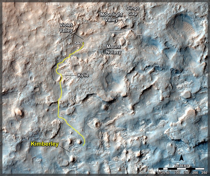
And here a quick update on Curiosity's travel route (as of 18 February 2014), showing her latest 'detour' down to a formation called Kimberly:
(NASA/JPL Source Link)
And here a quick update on Curiosity's travel route (as of 18 February 2014), showing her latest 'detour' down to a formation called Kimberly:
(NASA/JPL Source Link)
reply to post by jeep3r
From your source, and I was hoping they'd change the name of KMS-9. Who is Kimberley, and what's the backstory on that one? A memorial, or a reference to a living person? I'd love to have naming rights to something like that!!
From your source, and I was hoping they'd change the name of KMS-9. Who is Kimberley, and what's the backstory on that one? A memorial, or a reference to a living person? I'd love to have naming rights to something like that!!
This map shows the route driven and route planned for NASA's Curiosity Mars rover from before reaching "Dingo Gap" -- in upper right -- to the mission's next science waypoint, "Kimberley" (formerly referred to as "KMS-9") -- in lower left. The point labeled 547 on the route is where Curiosity finished a drive of 319 feet (100.3 meters) on the 547th Martian day, or sol, of the rover's mission on Mars (Feb. 18, 2014). The map's line to that point is the path actually traveled; the yellow line past that is a planned route.
reply to post by jeep3r
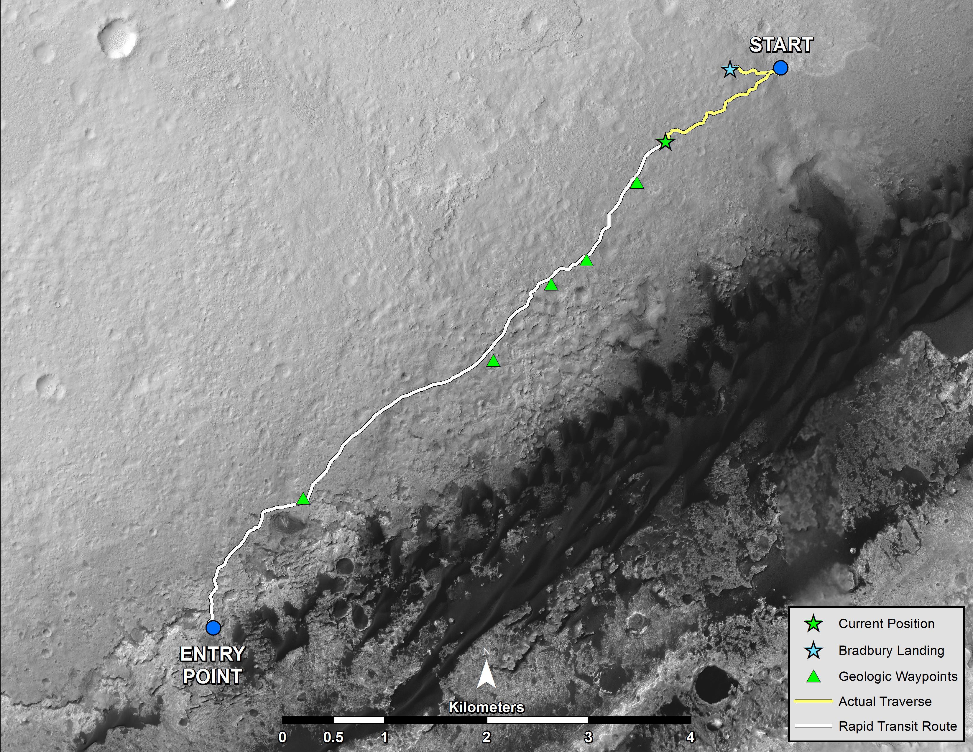
Yep, the rover is getting back on track, quite literally. Here is a larger context image (note, this is an old image and does not represent Curiosity's current location):
Source: photojournal.jpl.nasa.gov...
Kimberley is the second to last waypoint prior to entering the Murray Buttes. However, this entry point is subject to change especially given (a) changing rover and environmental conditions, and (b) changes to our understanding as to how Curiosity performs with sandy terrain and/or rocky terrain:
Source: www.jpl.nasa.gov...
The waypoint is named after Kimberley, in Australia:
Source: www.jpl.nasa.gov...
It will very interesting to see if the original route is changed and the reasons why. I suspect that there is a serious temptation to grab some more data on how the rover handles various terrain whilst in various modes of drive. That being the case, I would expect future navigation of (a) larger sand dunes, and (b) rocky terrain - in reverse drive.
Hopefully, no one pushes the rover too hard, too soon. Which gets me thinking... we do need a robotic aerial capability pretty badly.
PS. Here is a picture of ancient art found in the Kimberley, WA region of Australia:

Source: www.ufosightingshotspot.blogspot.com...
And some background material FYI:
phys.org...
Yep, the rover is getting back on track, quite literally. Here is a larger context image (note, this is an old image and does not represent Curiosity's current location):
Source: photojournal.jpl.nasa.gov...
Kimberley is the second to last waypoint prior to entering the Murray Buttes. However, this entry point is subject to change especially given (a) changing rover and environmental conditions, and (b) changes to our understanding as to how Curiosity performs with sandy terrain and/or rocky terrain:
"We have changed our focus to look at the big picture for getting to the slopes of Mount Sharp, assessing different potential routes and different entry points to the destination area," Erickson said. "No route will be perfect; we need to figure out the best of the imperfect ones."
Source: www.jpl.nasa.gov...
The waypoint is named after Kimberley, in Australia:
The science waypoint, which may be where Curiosity next uses its sample-collecting drill, is an intersection of different rock layers about two-thirds of a mile (about 1.1 kilometers) ahead on the planned route. This location, formerly called KMS-9 from when it was one of many waypoint candidates, is now called "Kimberley," for the geological mapping quadrant that contains it. The mapping quadrant was named for the northwestern Australia region with very old rocks.
Source: www.jpl.nasa.gov...
It will very interesting to see if the original route is changed and the reasons why. I suspect that there is a serious temptation to grab some more data on how the rover handles various terrain whilst in various modes of drive. That being the case, I would expect future navigation of (a) larger sand dunes, and (b) rocky terrain - in reverse drive.
Hopefully, no one pushes the rover too hard, too soon. Which gets me thinking... we do need a robotic aerial capability pretty badly.
PS. Here is a picture of ancient art found in the Kimberley, WA region of Australia:
Source: www.ufosightingshotspot.blogspot.com...
And some background material FYI:
phys.org...
edit on 22-2-2014 by Blister because: Provide background material on Kimberley
reply to post by Blister
As an older image, where would the Rover be now? Hopefully some easier driving ahead to save wear on the tires. Thanks for a very good post, and for explaining where the name Kimberly came from (not as romantic as I expected, but a nice reference to Australia).
As an older image, where would the Rover be now? Hopefully some easier driving ahead to save wear on the tires. Thanks for a very good post, and for explaining where the name Kimberly came from (not as romantic as I expected, but a nice reference to Australia).
edit on 22-2-2014 by Aleister
because: (no reason given)
reply to post by Aleister
Curiosity is west of the pre-planned waypoint immediately preceding Kimberley, near Dingo Gap. It is almost directly north of Kimberley, as shown in jeep3r's update.
Curiosity is west of the pre-planned waypoint immediately preceding Kimberley, near Dingo Gap. It is almost directly north of Kimberley, as shown in jeep3r's update.
Blister
reply to post by Aleister
Curiosity is west of the pre-planned waypoint immediately preceding Kimberley, near Dingo Gap. It is almost directly north of Kimberley, as shown in jeep3r's update.
Thanks. Knew that, but I was wondering which one of the green triangles on your new post is Kimberley. Is it the next one coming up, or has the Rover passed one or two of the green triangle science-points as yet. I should have been clearer in my question. And is there an easily found overhead pic such as your latest post which shows what comes after Murray Buttes - what pathways are possible from there on in. Thanks again! (On looking at the landing point again I realize how much Ray Bradbury would have loved that he was honored in such a way. He was very excited that Disneyland put up a Halloween Tree, and was like a little boy when those kind of things happened).
reply to post by Aleister
Here is the original planned route with the updated overlay:
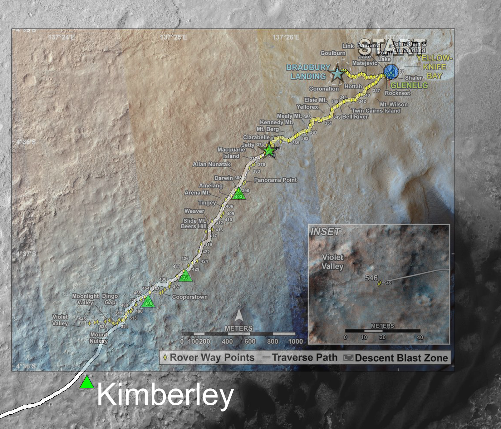
Kimberley is the next major scientific waypoint.
files.abovetopsecret.com...
Here is the original planned route with the updated overlay:
Kimberley is the next major scientific waypoint.
files.abovetopsecret.com...
edit on 22-2-2014 by Blister because: (no reason given)
reply to post by Blister
Thanks! Nice personal work there. Ah, the rover is much further along than I'd thought. We ride at midnight!
Thanks! Nice personal work there. Ah, the rover is much further along than I'd thought. We ride at midnight!
reply to post by Aleister
As for post-Buttes routes, they have not yet been decided. However, there are firm science targets that have long been of interest.
So, assuming that Curiosity passes safely through Murray Buttes (which may be rejected if other options are found) , it will drive south toward the gap in the dunes. This gap is not very large. A larger gap between dunes is further west, but this route could add an unnecessary 2 or 3 weeks to the route. Plus, there are no current science targets en-route westward (though of-course many could be found if that route was to be chosen).
Once at the gap in the dunes - which straddles an eroded crater, which is interesting - Curiosity will have a clear run toward Mount Sharp, apart from having to avoid some ridges that would otherwise be dangerous. These are some annotated pictures taken from a landing site analysis:
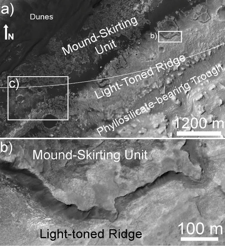
The route taken as the rover approaches the ascent could be affected by some pretty amazing geology:
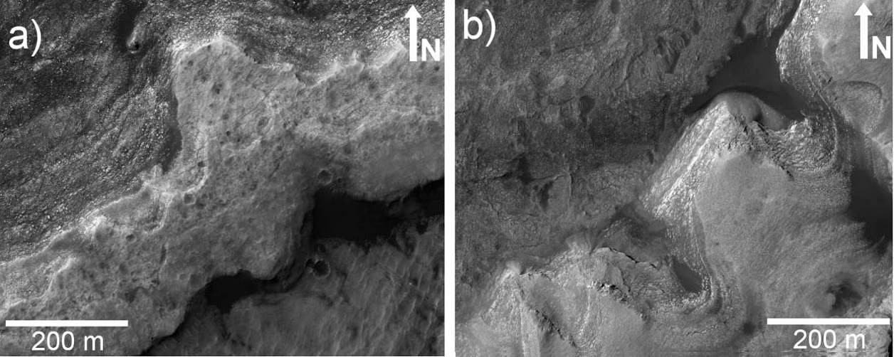
Source: marsjournal.org...
The above mentioned LTR (Light Toned Ridge) will be an obstacle to avoid. In places there is a steep drop-off or cliff of up to ten meters. Naturally, MSL does not want to fall off that! So a safe passage will be required that will allow for both safety and science. Personally, I would love the rover to climb the LTR, drive along it and then drive down a safe slope on the mountain-side of the ridge. If Curiosity travels south-west flowing the LTR it will come to a natural break in the ridge which should offer a safe and easier route to begin the ascent of Mt. Sharp.
For full details read: Ryan B. Anderson and James F. Bell III, "Geologic mapping and characterization of Gale Crater and implications for its potential as a Mars Science Laboratory landing site", Department of Astronomy, Cornell University, Mars 5, 76-128, 2010. (doi:10.1555/mars.2010.0004)
This is highly recommended reading for anyone interested in MSL Curiosity's mission.
As for post-Buttes routes, they have not yet been decided. However, there are firm science targets that have long been of interest.
So, assuming that Curiosity passes safely through Murray Buttes (which may be rejected if other options are found) , it will drive south toward the gap in the dunes. This gap is not very large. A larger gap between dunes is further west, but this route could add an unnecessary 2 or 3 weeks to the route. Plus, there are no current science targets en-route westward (though of-course many could be found if that route was to be chosen).
Once at the gap in the dunes - which straddles an eroded crater, which is interesting - Curiosity will have a clear run toward Mount Sharp, apart from having to avoid some ridges that would otherwise be dangerous. These are some annotated pictures taken from a landing site analysis:
The route taken as the rover approaches the ascent could be affected by some pretty amazing geology:
Source: marsjournal.org...
The above mentioned LTR (Light Toned Ridge) will be an obstacle to avoid. In places there is a steep drop-off or cliff of up to ten meters. Naturally, MSL does not want to fall off that! So a safe passage will be required that will allow for both safety and science. Personally, I would love the rover to climb the LTR, drive along it and then drive down a safe slope on the mountain-side of the ridge. If Curiosity travels south-west flowing the LTR it will come to a natural break in the ridge which should offer a safe and easier route to begin the ascent of Mt. Sharp.
For full details read: Ryan B. Anderson and James F. Bell III, "Geologic mapping and characterization of Gale Crater and implications for its potential as a Mars Science Laboratory landing site", Department of Astronomy, Cornell University, Mars 5, 76-128, 2010. (doi:10.1555/mars.2010.0004)
This is highly recommended reading for anyone interested in MSL Curiosity's mission.
edit on 22-2-2014 by Blister because: (no reason
given)
reply to post by Blister
I think it's more important to note to the destination of "Opportunity Rover"
www.abovetopsecret.com...
I think it's more important to note to the destination of "Opportunity Rover"
www.abovetopsecret.com...
reply to post by Blister
I think it may be due to the age of the rock formations in the Kimberley Desert, WA Australia. Geologists just found crystals in the same desert dated back to some 4.4Bn years.
They used that name because some parts of Australia have the oldest known rock and sediment formations on Earth.
I think it may be due to the age of the rock formations in the Kimberley Desert, WA Australia. Geologists just found crystals in the same desert dated back to some 4.4Bn years.
They used that name because some parts of Australia have the oldest known rock and sediment formations on Earth.
Source
The science waypoint, which may be where Curiosity next uses its sample-collecting drill, is an intersection of different rock layers about two-thirds of a mile (about 1.1 kilometers) ahead on the planned route. This location, formerly called KMS-9 from when it was one of many waypoint candidates, is now called "Kimberley," for the geological mapping quadrant that contains it. The mapping quadrant was named for the northwestern Australia region with very old rocks.
edit on 25/2/14 by Havick007 because: (no reason given)
Havick007
reply to post by Blister
I think it's more important to note to the destination of "Opportunity Rover"
www.abovetopsecret.com...
I'm sorry, I don't understand what you mean. Can you explain?
reply to post by Blister
Ok..
Look at the projected path of the Opportunity rover, it is heading into Endeavour Crater. Back in 2010, the linked post shows a structure on the very Eastern edge of Endeavour crater.
The only point I was trying to make is that Opportunity in heading towards a very interesting "anomaly".

I'm sorry, I know it is off-topic in regards to your OP but it is rover/Mars related. I'm not trying to derail your thread but I thought you may be interested
Here is the raw image - (The anomaly is at the lower on the image)
www.msss.com...
Just some information sharing
Ok..
Look at the projected path of the Opportunity rover, it is heading into Endeavour Crater. Back in 2010, the linked post shows a structure on the very Eastern edge of Endeavour crater.
The only point I was trying to make is that Opportunity in heading towards a very interesting "anomaly".
I'm sorry, I know it is off-topic in regards to your OP but it is rover/Mars related. I'm not trying to derail your thread but I thought you may be interested
Here is the raw image - (The anomaly is at the lower on the image)
www.msss.com...
Just some information sharing
edit on 25/2/14 by Havick007 because: (no reason given)
reply to post by Havick007
Why not bring your anomalies to the current anomalies thread, very welcome there but we will also call a rock a rock, and teach you why it is and how to realize it. This thread is for Curiosity's destination, a very important and interesting stand-alone subject.
www.abovetopsecret.com...
Why not bring your anomalies to the current anomalies thread, very welcome there but we will also call a rock a rock, and teach you why it is and how to realize it. This thread is for Curiosity's destination, a very important and interesting stand-alone subject.
www.abovetopsecret.com...
edit on 25-2-2014 by Aleister because: (no reason given)
reply to post by Aleister
I already have, instead of creating a new thread.. again!
I thought I'd share info a similar related thread.
Do0n't start trolling
I already have, instead of creating a new thread.. again!
I thought I'd share info a similar related thread.
Do0n't start trolling
Does anyone have an update on where Curiosity roams? Is it near the Buttes? Rounding a corner? Are we there yet?
a reply to: Aleister
You can always check out the map here: curiosityrover.com...
It's about 2/3rds of the way there.
You can always check out the map here: curiosityrover.com...
It's about 2/3rds of the way there.
new topics
-
When an Angel gets his or her wings
Conspiracies in Religions: 7 minutes ago -
Comparing the theology of Paul and Hebrews
Religion, Faith, And Theology: 54 minutes ago -
Pentagon acknowledges secret UFO project, the Kona Blue program | Vargas Reports
Aliens and UFOs: 1 hours ago -
Boston Dynamics say Farewell to Atlas
Science & Technology: 2 hours ago -
I hate dreaming
Rant: 2 hours ago -
Man sets himself on fire outside Donald Trump trial
Mainstream News: 4 hours ago -
Biden says little kids flip him the bird all the time.
2024 Elections: 4 hours ago -
The Democrats Take Control the House - Look what happened while you were sleeping
US Political Madness: 5 hours ago -
Sheetz facing racial discrimination lawsuit for considering criminal history in hiring
Social Issues and Civil Unrest: 5 hours ago -
In an Historic First, In N Out Burger Permanently Closes a Location
Mainstream News: 7 hours ago
top topics
-
In an Historic First, In N Out Burger Permanently Closes a Location
Mainstream News: 7 hours ago, 14 flags -
The Democrats Take Control the House - Look what happened while you were sleeping
US Political Madness: 5 hours ago, 12 flags -
A man of the people
Medical Issues & Conspiracies: 12 hours ago, 8 flags -
Man sets himself on fire outside Donald Trump trial
Mainstream News: 4 hours ago, 7 flags -
Biden says little kids flip him the bird all the time.
2024 Elections: 4 hours ago, 7 flags -
Pentagon acknowledges secret UFO project, the Kona Blue program | Vargas Reports
Aliens and UFOs: 1 hours ago, 4 flags -
4 plans of US elites to defeat Russia
New World Order: 14 hours ago, 4 flags -
Sheetz facing racial discrimination lawsuit for considering criminal history in hiring
Social Issues and Civil Unrest: 5 hours ago, 3 flags -
Are you ready for the return of Jesus Christ? Have you been cleansed by His blood?
Religion, Faith, And Theology: 10 hours ago, 3 flags -
MH370 Again....
Disaster Conspiracies: 7 hours ago, 2 flags
active topics
-
The Democrats Take Control the House - Look what happened while you were sleeping
US Political Madness • 49 • : WeMustCare -
Thousands Of Young Ukrainian Men Trying To Flee The Country To Avoid Conscription And The War
Other Current Events • 45 • : RickyD -
A man of the people
Medical Issues & Conspiracies • 10 • : Astrocometus -
Election Year 2024 - Interesting Election-Related Tidbits as They Happen.
2024 Elections • 65 • : Threadbarer -
When an Angel gets his or her wings
Conspiracies in Religions • 0 • : BrotherKinsMan -
Candidate TRUMP Now Has Crazy Judge JUAN MERCHAN After Him - The Stormy Daniels Hush-Money Case.
Political Conspiracies • 398 • : Zanti Misfit -
-@TH3WH17ERABB17- -Q- ---TIME TO SHOW THE WORLD--- -Part- --44--
Dissecting Disinformation • 545 • : cherokeetroy -
Man sets himself on fire outside Donald Trump trial
Mainstream News • 31 • : watchitburn -
12 jurors selected in Trump criminal trial
US Political Madness • 109 • : ImagoDei -
Boston Dynamics say Farewell to Atlas
Science & Technology • 2 • : theatreboy