It looks like you're using an Ad Blocker.
Please white-list or disable AboveTopSecret.com in your ad-blocking tool.
Thank you.
Some features of ATS will be disabled while you continue to use an ad-blocker.

Sabancaya Volcano Awakening
page: 16
share:
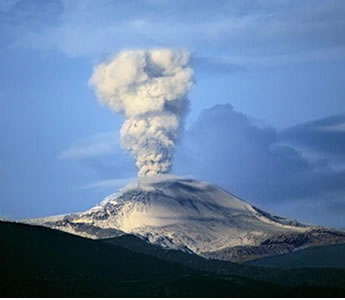
The Sabancaya volcano is located in the Colca Valley, department of Arequipa, Peru.
Yes, I've been reading about the increase of seismic activity in that area in the last days and knowing the area in person, I had a bad feeling that seems to be confirmed now. Arequipa city (capital of the department of same name), is near another volcano called Misti.
diariocorreo.pe...
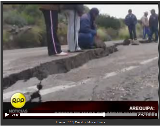
Maca, small town near the area had great seismic activity lately, as I mentioned before. Lots of earthquakes, the land is cracking all over and is rainning a lot, on top of that. Here a link with video, I know most of you don't know spanish but images are clear.
www.rpp.com.pe...
Will post more info if possible
Experts in geology and seismic activity indicated to this newspaper that three of the four earthquakes recorded in Maca, were not of tectonic or geological faults, but Sabancaya volcanic activity.
Yes, I've been reading about the increase of seismic activity in that area in the last days and knowing the area in person, I had a bad feeling that seems to be confirmed now. Arequipa city (capital of the department of same name), is near another volcano called Misti.
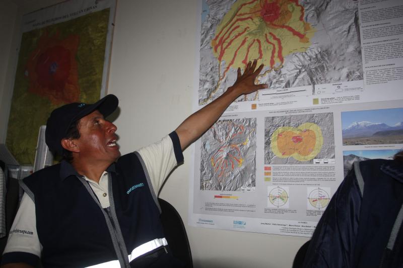
The Geological Mining and Metallurgical Institute has installed on site measurement and warning equipment such as GPS, seismographs, gas analyzers and remote sensing tools, among others.
Two days ago an expedition Ingemmet professionals came very near the crater (almost 6000 meters above sea level), and just at that moment there were volcanic earthquakes that rocked Maca and left dozens of homes damaged and over a hundred injured.
Residents of nearby areas are frightened and have indicated that in addition to the movements feel strange odor, prompting fears of a possible eruption.
According to sources, nearly Sabancaya breathing is hard enough for the strong smell of gas. In addition, the charged atmosphere is affecting and irritating the eyes of the locals.
Mail learned that in November last year had a first manifestation Sabancaya to expel visible fumaroles.
And ten days ago these were presented with more intensity and even change color.
Experts say that these demonstrations would be unmistakable that the volcano has been reactivated and is very likely to continue. Therefore, Civil Defense authorities should take forecasts that the case merits.
diariocorreo.pe...
Maca, small town near the area had great seismic activity lately, as I mentioned before. Lots of earthquakes, the land is cracking all over and is rainning a lot, on top of that. Here a link with video, I know most of you don't know spanish but images are clear.
In addition, the land fell and caused a crack that alarmed the population.
www.rpp.com.pe...
Will post more info if possible
edit on 24-2-2013 by Trueman because: (no reason given)
edit on 24-2-2013 by Trueman
because: (no reason given)
edit on 24-2-2013 by Trueman because: (no reason given)
reply to post by poet1b
Here some more info :
volcano.oregonstate.edu...
www.volcano.si.edu...
Here some more info :
Volcan Sabancaya (S) is the youngest component of a complex consisting of three centers; Nevado Hualca Hualca to the north (HH), Sabancaya, and Nevado Ambato (NA) to the south.
Sabancaya presents similar, but less severe hazard to Coropuna. About 30,000 people leave along the Rio Colca and Sihuas valleys near the complex. Mud and lava flow hazard is obvious, and pyroclastic hazard cannot be ruled out. Mudflows from the north-eastern flank could enter the Majes drainages (which hosts a major canal network resulting from an ogoing irrigation project in the area), while mudflows from the other flanks could enter the south flowing Rio Siguasi. During the 1988 activity cattle died in the areas adjacent to Sabancaya, either directly from poisonous fumes or from eating contaminated foliage (SEAN June 1988). Lavas erupted from vents in the erosional amphitheater on the northern flanks of Hualca Hualca have entered the Rio Majes canyon in the past and dammed it completely - the satellite images show flat-lying lake sediments deposited behind a breached dam, which also forms a prominent nick-point in the canyon profile. Breach of the dam may have caused serious flooding downstream at the time.
volcano.oregonstate.edu...
www.volcano.si.edu...
Look like local authorities think it could be serious, got this few mins ago :
They had a meeting with "Defensa Civil" (Defensa Civil is like FEMA for us).
www.andina.com.pe...
11:46 Emergency Operations Center in Sabancaya area will be Installed.
Arequipa, in February. 24 (ANDINA). An Emergency Operations Center and Early Warning System will be installed in the area of influence of Sabancaya, in Arequipa, in order to monitor its behavior in recent days, the Institute of Geology, Mining and Metallurgy (Ingemmet).
They had a meeting with "Defensa Civil" (Defensa Civil is like FEMA for us).
www.andina.com.pe...
edit on
24-2-2013 by Trueman because: (no reason given)
This might actually be very bad
from wikipedia
So i'm no genius but if I remember correctly from school, a stratovolcano is a vulcano which is capable of spewing ashes in the stratosphere?
3 day of darkness? anyone
S&F
from wikipedia
Sabancaya is an active 5,976-metre (19,606 ft) stratovolcano in the Andes of southern Peru
So i'm no genius but if I remember correctly from school, a stratovolcano is a vulcano which is capable of spewing ashes in the stratosphere?
3 day of darkness? anyone
S&F
reply to post by Senduko
There are 12 volcanoes in the same area (Southern Peru), right in front of the Nazca Tectonic Plate.
volcanes.ingemmet.gob.pe:86...
There are 12 volcanoes in the same area (Southern Peru), right in front of the Nazca Tectonic Plate.
Central Volcanic Zone of the Andes (CVZ) where is located the 12 active and potentially active volcanoes of southern Peru: Sara Sara, Coropuna, Sabancaya, Chachani, Misti, Ubinas, Huaynaputina, Ticsani, Tutupaca, Yucamane and Casiri.
volcanes.ingemmet.gob.pe:86...
edit on 24-2-2013 by Trueman because:
(no reason given)
Stratovolcano...
A stratovolcano, also known as a composite volcano,[1] is a tall, conical volcano built up by many layers (strata) of hardened lava, tephra, pumice, and volcanic ash. Unlike shield volcanoes, stratovolcanoes are characterized by a steep profile and periodic explosive eruptions and quiet eruptions, while there are some with collapsed craters called calderas. The lava that flows from stratovolcanoes typically cools and hardens before spreading far due to high viscosity. The magma forming this lava is often felsic, having high-to-intermediate levels of silica (as in rhyolite, dacite, or andesite), with lesser amounts of less-viscous mafic magma. Extensive felsic lava flows are uncommon, but have travelled as far as 15 km (9.3 mi).[2] Stratovolcanoes are sometimes called "composite volcanoes" because of their composite layered structure built up from sequential outpourings of eruptive materials. They are among the most common types of volcanoes, in contrast to the less common shield volcanoes. Two famous stratovolcanoes are Krakatoa, best known for its catastrophic eruption in 1883 and Vesuvius, famous for its destruction of the towns Pompeii and Herculaneum in 79 AD. Both eruptions claimed thousands of lives.
From WIKI
With a VEI of 3, it doesn't look like anything serious.
The most sustained period of activity began with explosive eruptions on May 28, 1990, and continued for over eight years. The eruptive cycle rated a VEI of 3, with more than 25 million cubic metres (880×106 cu ft) of lava flows and tephra produced over that period. At the height of the activity in 1994, eruptions producing large ash clouds occurred every two hours. Although published topographic maps have not been revised since the eruptive cycyle, it is suspected that the cone may have grown to just over 6,000 metres (20,000 ft) during that time.[1] Additional smaller eruptions occurred in 2000 and 2003 Hasta el momentos no se sabe muy bien en el 2010 y 2011.
With a VEI of 3, it doesn't look like anything serious.
Originally posted by solargeddon
From WIKI
The most sustained period of activity began with explosive eruptions on May 28, 1990, and continued for over eight years. The eruptive cycle rated a VEI of 3, with more than 25 million cubic metres (880×106 cu ft) of lava flows and tephra produced over that period. At the height of the activity in 1994, eruptions producing large ash clouds occurred every two hours. Although published topographic maps have not been revised since the eruptive cycyle, it is suspected that the cone may have grown to just over 6,000 metres (20,000 ft) during that time.[1] Additional smaller eruptions occurred in 2000 and 2003 Hasta el momentos no se sabe muy bien en el 2010 y 2011.
With a VEI of 3, it doesn't look like anything serious.
You need to read and understand your own post, that information is not updated. Notice the last sentence in spanish ????
Hasta el momentos no se sabe muy bien en el 2010 y 2011
That means this : "Up to now it is not known very well in 2010 and 2011".
It was 2013 when I woke up this morning.
reply to post by Trueman
Doesn't really make a difference, its still isn't a game changer, I was being kind to add the wiki source, the other source I read put it at 2, with a question mark.
Point is Volcanoes erupt all the time, without dire consequences, I predict the same for this one, it is even less remarkable given that it erupts at regular intervals.
Originally posted by Trueman
reply to post by Senduko
There are 12 volcanoes in the same area (Southern Peru), right in front of the Nazca Tectonic Plate.
Central Volcanic Zone of the Andes (CVZ) where is located the 12 active and potentially active volcanoes of southern Peru: Sara Sara, Coropuna, Sabancaya, Chachani, Misti, Ubinas, Huaynaputina, Ticsani, Tutupaca, Yucamane and Casiri.
volcanes.ingemmet.gob.pe:86...edit on 24-2-2013 by Trueman because: (no reason given)
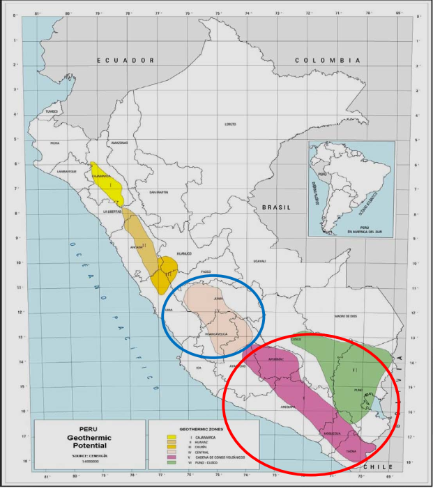
It seems like most of the volcanoes that are getting active have been recently used for geothermal energy or exploration wells for that purpose had recently been drilled, wonder if that is true here.
Originally posted by solargeddon
reply to post by Trueman
Doesn't really make a difference, its still isn't a game changer, I was being kind to add the wiki source, the other source I read put it at 2, with a question mark.
Point is Volcanoes erupt all the time, without dire consequences, I predict the same for this one, it is even less remarkable given that it erupts at regular intervals.
I wonder how bad it need to be according to you in order to be considered serious. Local authorities are already taking actions instead of waiting for a "game changer" event. You are not reading the posts and links obviously.
reply to post by Char-Lee
Geothermal energy aven't been developed in Peru yet, but there is an intention to do so soon.
alterrapower.ca...
www.cepal.org...
Geothermal energy aven't been developed in Peru yet, but there is an intention to do so soon.
alterrapower.ca...
www.cepal.org...
reply to post by Trueman
Wonder if they have been doing exploratory wells, there seems to be a correlation between those explorations and some areas acting up.
Wonder if they have been doing exploratory wells, there seems to be a correlation between those explorations and some areas acting up.
reply to post by Char-Lee
Something like this ?
en.wikipedia.org...
Something like this ?
In July 1981 the Peruvian government signed an oil contract for blocks 38 and 42 with Royal Dutch Shell. The contract covered approximately 20,000 square kilometres (7,700 sq mi) in the southern part of the Ucayali Basin.[citation needed] The Camisea gas fields were discovered in 1986 by Shell.[1] By 1987, two non-associated natural gas fields, San Martín and Cashiriari, were approved economically feasible. In March 1988, the preliminary agreement on exploration was signed between Petroperú and Shell. However, the talks ended in August of that year without reaching a final ageement.[
en.wikipedia.org...
UPDATE
I'll check again after work to see what they said. Hope good news.
diariocorreo.pe...
February 24, 2013 | Arequipa -
Specialists Geological Mining and Metallurgical Institute (Ingemmet) meet in the afternoon with Regional Government to inform the situation Sabancaya Volcano.
After the meeting there will be a press conference to publicize the measures taken on.
I'll check again after work to see what they said. Hope good news.
diariocorreo.pe...
UPDATE
No good news.....
diariocorreo.pe...
elcomercio.pe...
No good news.....
12:19 | Arequipa -
The Sabancaya is on yellow alert. As reported by the Geological Mining and Metallurgical Institute (Ingemmet), vents, reaching a thousand meters high, can be seen from 10 or 12 miles around and seismic activity experienced a large increase.
diariocorreo.pe...
Arequipa: 536 earthquakes detected beneath the volcano Sabancaya in two days. Ingemmet official said the recordings were made on 22 and 23 February. The figure is abnormal and unusual,
elcomercio.pe...
new topics
-
Cats Used as Live Bait to Train Ferocious Pitbulls in Illegal NYC Dogfighting
Social Issues and Civil Unrest: 57 minutes ago -
The Good News According to Jesus - Episode 1
Religion, Faith, And Theology: 2 hours ago -
HORRIBLE !! Russian Soldier Drinking Own Urine To Survive In Battle
World War Three: 4 hours ago -
Bobiverse
Fantasy & Science Fiction: 7 hours ago -
Florida man's trip overseas ends in shock over $143,000 T-Mobile phone bill
Social Issues and Civil Unrest: 7 hours ago -
Former Labour minister Frank Field dies aged 81
People: 10 hours ago -
SETI chief says US has no evidence for alien technology. 'And we never have'
Aliens and UFOs: 11 hours ago
top topics
-
President BIDEN Vows to Make Americans Pay More Federal Taxes in 2025 - Political Suicide.
2024 Elections: 16 hours ago, 19 flags -
Florida man's trip overseas ends in shock over $143,000 T-Mobile phone bill
Social Issues and Civil Unrest: 7 hours ago, 8 flags -
SETI chief says US has no evidence for alien technology. 'And we never have'
Aliens and UFOs: 11 hours ago, 7 flags -
Former Labour minister Frank Field dies aged 81
People: 10 hours ago, 4 flags -
Bobiverse
Fantasy & Science Fiction: 7 hours ago, 3 flags -
Ode to Artemis
General Chit Chat: 17 hours ago, 3 flags -
This is our Story
General Entertainment: 14 hours ago, 3 flags -
Cats Used as Live Bait to Train Ferocious Pitbulls in Illegal NYC Dogfighting
Social Issues and Civil Unrest: 57 minutes ago, 3 flags -
HORRIBLE !! Russian Soldier Drinking Own Urine To Survive In Battle
World War Three: 4 hours ago, 2 flags -
The Good News According to Jesus - Episode 1
Religion, Faith, And Theology: 2 hours ago, 0 flags
active topics
-
Mood Music Part VI
Music • 3098 • : BrucellaOrchitis -
-@TH3WH17ERABB17- -Q- ---TIME TO SHOW THE WORLD--- -Part- --44--
Dissecting Disinformation • 648 • : RookQueen2 -
HORRIBLE !! Russian Soldier Drinking Own Urine To Survive In Battle
World War Three • 19 • : KnowItAllKnowNothin -
Florida man's trip overseas ends in shock over $143,000 T-Mobile phone bill
Social Issues and Civil Unrest • 14 • : Raptured -
DerBeobachter - Electric Boogaloo 2
Introductions • 14 • : ElitePlebeian2 -
LaBTop is back at last.
Introductions • 16 • : ElitePlebeian2 -
VirginOfGrand says hello
Introductions • 4 • : ElitePlebeian2 -
TLDR post about ATS and why I love it and hope we all stay together somewhere
General Chit Chat • 9 • : ElitePlebeian2 -
SETI chief says US has no evidence for alien technology. 'And we never have'
Aliens and UFOs • 32 • : bhtaylor53 -
Breaking Baltimore, ship brings down bridge, mass casualties
Other Current Events • 480 • : IndieA
6