It looks like you're using an Ad Blocker.
Please white-list or disable AboveTopSecret.com in your ad-blocking tool.
Thank you.
Some features of ATS will be disabled while you continue to use an ad-blocker.

Curiosity/MSL: My take on the discoveries at GALE CRATER so far (video)
page: 2share:
The following is my opinion as a member participating in this discussion.
reply to post by jeep3r
I am going to look at this more in detail (I watched the video yesterday ) now, as I didn't have the time during the weekend (too much work ).
I will try to get an idea of the whole area, including sizes and distances.
I will see what I can find.
As an ATS Staff Member, I will not moderate in threads such as this where I have participated as a member.
Originally posted by ArMaP
reply to post by jeep3r
I am going to look at this more in detail (I watched the video yesterday ) now, as I didn't have the time during the weekend (too much work ).
I will try to get an idea of the whole area, including sizes and distances.
I will see what I can find.
Thanks a lot, ArMaP!
A critical view from someone else would indeed be helpful in this case. I'm quite confident that I got the positions/locations more or less right on the map. In any case, I very much look forward to your take on this ...
Great vid, my thread on a propeller found of mars backs your theory. The whole area reminds me of ancient malta on earth.
Originally posted by symptomoftheuniverse
Great vid, my thread on a propeller found of mars backs your theory. The whole area reminds me of ancient malta on earth.
That propeller that only you can seem to see?
any idiot can see its a propeller. Why dont you think its a propeller? Is it because its on mars?
Originally posted by Mickles
Originally posted by symptomoftheuniverse
Great vid, my thread on a propeller found of mars backs your theory. The whole area reminds me of ancient malta on earth.
That propeller that only you can seem to see?
Originally posted by symptomoftheuniverse
Great vid
Thank you!
my thread on a propeller found of mars backs your theory.
That might be the case if - what you saw - were indeed a propeller. As far as I'm concerned, I usually try 'not' to link my assumptions to one artifact only, since pure visual evidence can be very deceptive. If you do so, you can be sure that the 'rock-people' will invade your thread and tear it to shreds.
And concerning your differences with other members of this forum: may I kindly ask you to carry on with your arguments in your own thread? Thanks in advance ...
reply to post by thegreatone666
interesting thread. i can't believe that guy is still beating the dead horse.
interesting thread. i can't believe that guy is still beating the dead horse.
i have no problems with other members i merely tried to support your evidence. The other members is whom you should be addressing.
Originally posted by jeep3r
Originally posted by symptomoftheuniverse
Great vid
Thank you!
my thread on a propeller found of mars backs your theory.
That might be the case if - what you saw - were indeed a propeller. As far as I'm concerned, I usually try 'not' to link my assumptions to one artifact only, since pure visual evidence can be very deceptive. If you do so, you can be sure that the 'rock-people' will invade your thread and tear it to shreds.
And concerning your differences with other members of this forum: may I kindly ask you to carry on with your arguments in your own thread? Thanks in advance ...[/
I have done different threads,its not just 1 artifact.
Originally posted by symptomoftheuniverse
i merely tried to support your evidence.
Well, your support is indeed appreciated!
I have done different threads,its not just 1 artifact.
Then it's time to collect everything and start a new thread with what you've got, I guess. On the other hand: you earned 5 flags and 160+ replies in your recent thread, so you definitely got some serious attention there. In any case: keep looking and don't give in!
Originally posted by ArMaP
reply to post by jeep3r
I am going to look at this more in detail (...)
I will try to get an idea of the whole area, including sizes and distances.
I will see what I can find.
Hey there, ArMaP!
Just wanted to check back whether you already found something regarding Curiosity's traverse-path. On the other hand, it may take some time to get a good and detailed overview of the overall situation including all the material available at NASA/JPL.
Apart from that, I also noticed that you're quite busy moderating and can imagine that you didn't get to look into this as of yet. But I'm still curious concerning your opinion on this ... thanks in advance!
edit on 1-3-2013 by jeep3r because: removed 'mod' tags
edit
on 1-3-2013 by jeep3r because: (no reason given)
reply to post by jeep3r
This week has been too busy, but I think I can get some time this weekend and, if I do, I will post my findings.
For now, I can only say that I am a little (well, more than just a little ) sceptical about your interpretation, so I am trying to see if there are other photos from different angles that may give us a different perspective.
Originally posted by ArMaP
reply to post by jeep3r
This week has been too busy, but I think I can get some time this weekend and, if I do, I will post my findings.
For now, I can only say that I am a little (well, more than just a little ) sceptical about your interpretation, so I am trying to see if there are other photos from different angles that may give us a different perspective.
Thanks for the quick reply and no worries: I don't expect anyone to actually 'buy' into this!
I'm quite sceptical myself and the interpretation really seems to be far-fetched, but I just couldn't resist the gut feeling in the light of those 'formations' that do seem to share some common features.
If it wasn't for that, and all the other scrap lying around (making Rocknest look like a junkyard), it would be easier to just move on and not think about it any further.
edit on 2-3-2013 by jeep3r because: text
Time for a quick update in this thread:
My previous scale estimations (see here) may not have been as accurate as I thought they would be. After looking through MSL images from other Sols, I noticed that the point of reference ("Edgy Hill Landmark") may as well be the landmark which had been coined "POINT LAKE" by NASA/JPL.
I also checked the original panorama released by NASA/JPL in November 2012 (see here) and think their description would fit to the location names both on the maps and in the terrain. Below is a projection of the probable area-tags onto the Sol 64 panorama that shows POINT LAKE as a distinct rock formation roughly resembling a cliff or embankment:
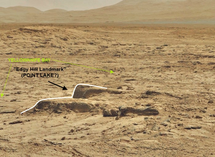
And the same view with 'more context':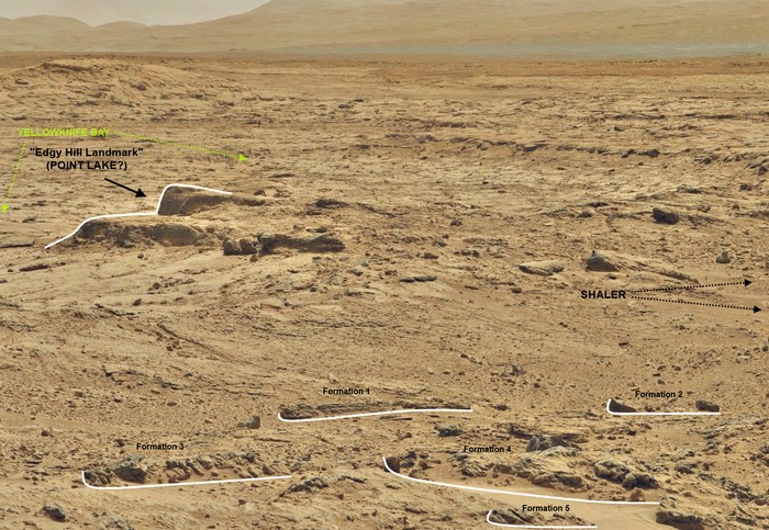 Click here for a
larger version of the image above.
Click here for a
larger version of the image above.
------------------------------------------------------------------------------------
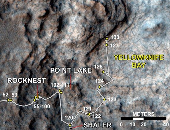
And for comparison, here goes Curiosity's traverse path through Sol 130:
 Click here for the full-size image of the traverse path provided by
NASA/JPL.
Click here for the full-size image of the traverse path provided by
NASA/JPL.
And here goes another link to a route-map on UMSF.
When taking all this into account, Curiosity was probably much closer to POINT LAKE than I initially thought while the Rocknest panorama had been acquired during Sols 64-72 (click here for the panorama on Gigapan). This also means, that the intriguing 'rock formations' (or ship anomalies) that I located in that area would be much smaller than previously estimated.
But independent of the actual scale, I still think those features or formations are difficult to explain (eg. as ventifacts), because of their geometrical alignment and a variety of similar shapes, angles and other features that are not only found in this area, but in many places across POINT LAKE, ROCKNEST and SHALER.
If anyone can confirm these location or area tags, please let me know. Or in case you have explanations for any of those peculiar formations (for example this), I'd be happy to discuss this more in detail ...
... and I promise to keep an open mind!
My previous scale estimations (see here) may not have been as accurate as I thought they would be. After looking through MSL images from other Sols, I noticed that the point of reference ("Edgy Hill Landmark") may as well be the landmark which had been coined "POINT LAKE" by NASA/JPL.
I also checked the original panorama released by NASA/JPL in November 2012 (see here) and think their description would fit to the location names both on the maps and in the terrain. Below is a projection of the probable area-tags onto the Sol 64 panorama that shows POINT LAKE as a distinct rock formation roughly resembling a cliff or embankment:
And the same view with 'more context':
------------------------------------------------------------------------------------
And for comparison, here goes Curiosity's traverse path through Sol 130:
And here goes another link to a route-map on UMSF.
When taking all this into account, Curiosity was probably much closer to POINT LAKE than I initially thought while the Rocknest panorama had been acquired during Sols 64-72 (click here for the panorama on Gigapan). This also means, that the intriguing 'rock formations' (or ship anomalies) that I located in that area would be much smaller than previously estimated.
But independent of the actual scale, I still think those features or formations are difficult to explain (eg. as ventifacts), because of their geometrical alignment and a variety of similar shapes, angles and other features that are not only found in this area, but in many places across POINT LAKE, ROCKNEST and SHALER.
If anyone can confirm these location or area tags, please let me know. Or in case you have explanations for any of those peculiar formations (for example this), I'd be happy to discuss this more in detail ...
... and I promise to keep an open mind!
edit on 1-4-2013 by jeep3r because: spelling
Hey jeep3r,
It is always interesting to read your posts.
It is always with a healthy dose of skeptism that I read and look, wondering what on earth you are seeing. The nice patterns and colors you use always get me wondering....
I do believe that you are more right than most people give you credit for. I do however, feel that you are so intent upon looking at what I may describe as the " Micro-level" findings (such as obvious flood/mud debris from some cataclysm) yet fail to see what is staring you in the face at a greater level, or Macro-level..
For example, paying total attention to Curiosity ignores the great recent pictures coming from Opportunity:
marsrovers.jpl.nasa.gov...
At the top-left, the viewer can see a fantastic, weather beaten remains of some sort of container. Whatever it was is long since (whatever cataclysm that which occurred) been destroyed, almost to the point of non-recognition. Yet, the clear, and typical, outline of a hollow-walled container (though seriously damaged) remain.
On the other hand, at the macro-level, as one reader had observed, NASA/JPL/MSL has rarely taken 100mm pictures of the area to which Curiosity is headed, There are panoramic pictures available, though almost all these are using the lower resolution camera. NASA appears unwilling to use the 100mm to its full potential.... have you ever wondered why? The answers will become clear should Curiosity reach its destination over the next 2+ years:
www.abovetopsecret.com...
Regardless, we think you are so close to breaking the case and always enjoy your posts
Keep up the great work! S&F
edit on 1-4-2013 by Blister because: (no reason given)
Originally posted by Blister
At the top-left, the viewer can see a fantastic, weather beaten remains of some sort of container.
It's an interesting photo, but I don't think it shows some kind of container, as we don't see the rest of the "wall".
There are panoramic pictures available, though almost all these are using the lower resolution camera. NASA appears unwilling to use the 100mm to its full potential.... have you ever wondered why?
Have you ever tried to take photos to make a panorama? If you did, did you try doing it with the zoom at the maximum? I did, and it takes many more photos to cover the same area as doing it with a shorter focal length (wider field of view).
Originally posted by ArMaP
It's an interesting photo, but I don't think it shows some kind of container, as we don't see the rest of the "wall".
Hey, I can color it in if you want.
Have you ever tried to take photos to make a panorama? If you did, did you try doing it with the zoom at the maximum? I did, and it takes many more photos to cover the same area as doing it with a shorter focal length (wider field of view).
Come now, ArMaP. Your response to MSL's non-use of the 100mm camera is inane - NASA makes composite pictures all the time. Why would they not want a composite picture of such amazing detail? I have no answer to that, except the rather searching hypothesis that NASA doesn't feel that the time is right to allow people to see in such high detail. Even if they did not stitch the individual images together they would be fantastic resource.
Oh, yes, on the issue as to what a "panorama" is, I would counter that a panorama need not be a composite of stitched images, as we see typically from MSL. One picture or photo can be a panorama, as the term is actually a very subjective one, though generally understood.
Regardless, keep on!
edit on 2-4-2013 by Blister because: (no reason given)
Originally posted by Blister
Hey, I can color it in if you want.
That wouldn't show what is not on the photo, that's what I meant.
Your response to MSL's non-use of the 100mm camera is inane - NASA makes composite pictures all the time. Why would they not want a composite picture of such amazing detail?
Because one photo from the 100 mm camera of the area seen in one photo from the 34 mm camera uses 9 times as much data, so a panorama made with 50 photos from the 34 mm camera would turn into a 450 photos panorama.
It would look great, but it would take much longer to transmit back to Earth.
Oh, yes, on the issue as to what a "panorama" is, I would counter that a panorama need not be a composite of stitched images, as we see typically from MSL
In this context it means only one thing, specially when we are talking about a 100 mm lens.
new topics
-
The Baloney aka BS Detection Kit
Social Issues and Civil Unrest: 3 hours ago -
Suspected Iranian agent working for Pentagon while U.S. coordinated defense of Israel
US Political Madness: 4 hours ago -
How does my computer know
Education and Media: 7 hours ago -
USO 10 miles west of caladesi island, Clearwater beach Florida
Aliens and UFOs: 11 hours ago
top topics
-
USO 10 miles west of caladesi island, Clearwater beach Florida
Aliens and UFOs: 11 hours ago, 8 flags -
Suspected Iranian agent working for Pentagon while U.S. coordinated defense of Israel
US Political Madness: 4 hours ago, 5 flags -
How does my computer know
Education and Media: 7 hours ago, 2 flags -
The Baloney aka BS Detection Kit
Social Issues and Civil Unrest: 3 hours ago, 2 flags
active topics
-
Running Through Idiot Protestors Who Block The Road
Rant • 48 • : YourFaceAgain -
How does my computer know
Education and Media • 12 • : mysterioustranger -
Candidate TRUMP Now Has Crazy Judge JUAN MERCHAN After Him - The Stormy Daniels Hush-Money Case.
Political Conspiracies • 193 • : Vermilion -
Gold and silver prices....woo hoo
History • 73 • : mysterioustranger -
-@TH3WH17ERABB17- -Q- ---TIME TO SHOW THE WORLD--- -Part- --44--
Dissecting Disinformation • 475 • : fringeofthefringe -
White clots found in 20% of dead bodies after covid vaccine
Medical Issues & Conspiracies • 41 • : Kurokage -
The Baloney aka BS Detection Kit
Social Issues and Civil Unrest • 3 • : mysterioustranger -
Nakedeye Mother of Dragons Comet Is Here!
Space Exploration • 3 • : SchrodingersRat -
US and Israel Reportedly Conclude Most Hostages Still Held in Gaza Are Dead
War On Terrorism • 146 • : Ohanka -
Negotiations and Diplomacy.
History • 13 • : Kurokage