It looks like you're using an Ad Blocker.
Please white-list or disable AboveTopSecret.com in your ad-blocking tool.
Thank you.
Some features of ATS will be disabled while you continue to use an ad-blocker.

The Naska Lines: An Alien Blueprint. (amazing discovery!)
page: 15share:
I really think you're wasting time, there is no way to properly plot those lines without a computer program going over thousands of possibilities for
lapping
There is no way you could tell the difference between old and "newer" lines by looking at satellite imagery. To properly test any theory regarding
the purpose of the Nazca lines you need to have some understanding of how the site has been occupied during certain eras of its existence. Again, you
would need access to data, which has been collected during numerous archaeological survey's of the site, that allows you to layer the lines based on
when they were drawn. A huge problem with the approach of tracing every line, is that many of the things you may trace are superfluous either because
they are irrelevant to the theory you are seeking to test, or are not even true Nasca lines. Due to the aesthetic, subjective nature of the approach,
many of the lines that will end up being traced may not actually be Nasca lines at all. Some may be natural features, others will be lines which have
been skewed by natural occurrences, others still may be modern day paths created by tourists, and a great majority of the lines will be from
significantly different era's of occupation which are not necessarily linked by one in situ non changing culture. To illustrate how much more
complex of a problem this is than many may appreciate, modern professional survey's go to great lengths to reference survey's conducted in the 60's
because the terrain has changed so much over the past 50 years.
To approach this problem properly some preliminary facts should be understood as well. The site has been occupied for 4,000 years (or 2,000 depending on what journal article you want to follow) but a majority of the lines and petroglyphs date to 400-650 AD. There is a pretty concrete time line of people moving to and fro Nasca. Changes in material culture at the site demonstrate that the site went through at least five distinct "era's". It is clear that how people have utilized the site has changed greatly over its period of occupation, and these things are well traced through the archaeological record (read the articles I posted above and reach your own conclusions).
What is the thesis that you are trying to test?
1) Over the course of a 4,000 year history a distinct, ancient and misunderstood society has been creating some message by means of monumental construction? The problem with this theory is that most of the lines, if not all of them, date to only 400 AD. Further, we have a pretty good understanding that the site was not settled during its entire occupation, by one distinct social group. If very ancient lines exist, and some modern evidence suggests that they may, these lines were likely created by very a very different cultural entity than the people who made a great majority of the lines post 400 AD. To put this in prospective, think about how much your home community has changed over the past 20 years, than extrapolate that over millenea. The people who occupied the site 4,000 years ago likely had a very different cultural identity than the people who occupied it 400 years ago. Therefore to get a good idea of what really happens you would have to trace out the lines based on era of occupation, and then if necessary overlay them to get the most concrete understanding of what was going on at Nasca. Just for note, analysis of material culture seems to demonstrate an ebb and flow of occupation directly linked to rain and drought activity
2) Did a single event transpire at the site, that inspired its occupants, whomever they be, to transfer a message by means of monumental construction? To answer this question you would need to know the dates of the lines to properly test it. It is clear that some societal change took place around 400 AD because the in situ culture began making the lines in monumental fashion. What caused this cultural shift is still hotly debated. If you think that Aliens touched down at Nasca in 400 AD and left behind a blue print, that's a fair theory. But to properly test it you need to know what lines appeared in 400 AD and what lines appeared prior to and hundreds of years after. Current accepted theories behind the lines appearing in 400 AD range from textile manufacturing to ceremonial marching. Most people who have studied the culture during this era have advanced numerous arguments that whatever the ceremonial activity may have been, it was likely related to rain/drought.
Extensive modeling, field testing, and peer reviewed scholarship has been done on this subject, you may want to take 20 min's of your time reading a couple articles before spending hours on MS paint if you're really interested. If someone could get the data of the actual survey's (i've tried) we could all actually put some real work into this mystery.
edit on 17-2-2013 by IndianaJoe because: (no reason given)
edit on
17-2-2013 by IndianaJoe because: (no reason given)
edit on 17-2-2013 by IndianaJoe because: (no reason given)
reply to post by IndianaJoe
Superb post IndianaJoe, however I suspect you might as well be shouting into a cave.
These guys are having too much fun with MS Paint drawing to do any actual reading or research.
Superb post IndianaJoe, however I suspect you might as well be shouting into a cave.
These guys are having too much fun with MS Paint drawing to do any actual reading or research.
reply to post by Kitora
Doesn't this look much like
From a different view-point that is. The lines crossing it might be wind, or a current even. Just a thought.
Doesn't this look much like
From a different view-point that is. The lines crossing it might be wind, or a current even. Just a thought.
In regards to erosion.
People in this thread say that there is no wind in the Nazca dessert. If you watch this:
www.youtube.com...
At about 1010s You can clearly see the wind and the fact that the woman states that all bones are uncovered by erosion.
People in this thread say that there is no wind in the Nazca dessert. If you watch this:
www.youtube.com...
At about 1010s You can clearly see the wind and the fact that the woman states that all bones are uncovered by erosion.
edit on 17-2-2013 by
litepegr because: (no reason given)
Really great work! I am always skeptical when it comes to this type of analysis, since the mind does have a tendency to find patterns even when they
may not exist. However, the Nazca lines are a special case, in that they are unique to that area and only visible from above. It would certainly make
sense that whatever created them, human or otherwise, may have done so as a means of preserving a very important set of instructions. Plus, these just
look plain awesome!
Hello ATS!
Thanks everyone, for all the comments and the ATS Live discussion. I am excited to see how many people have offered their help with this. There have been a lot of good ideas of how to tackle this and I am looking forward to seeing the results. I’m going to reply to several members in this single post.
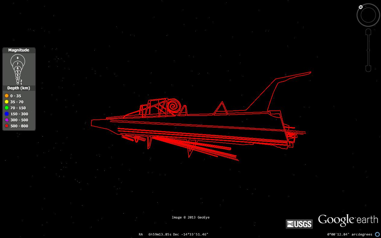
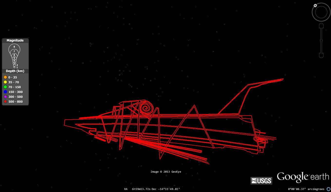
That is the same depiction as the one below. It is on a different mountain and flipped around.
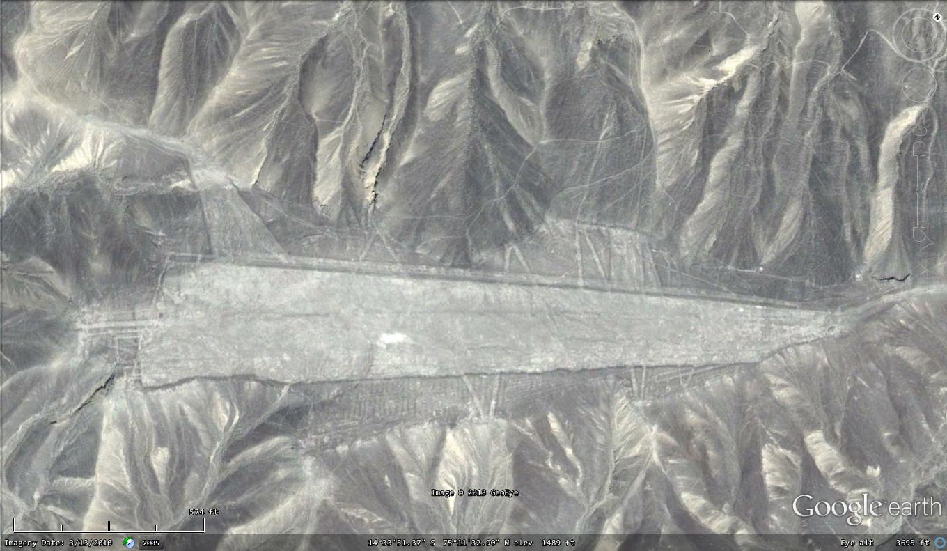
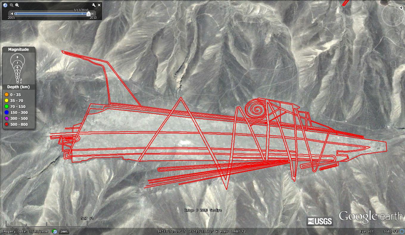
I just realized that this picture was not finished and I had only half redone with outline. To show the importance of outlining as opposed to just tracing I am providing a before and after picture.
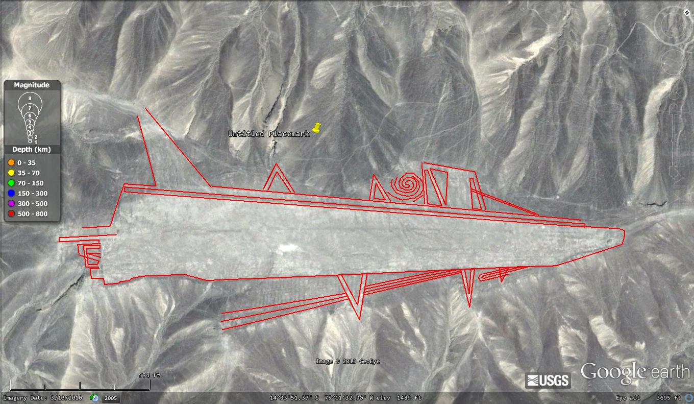
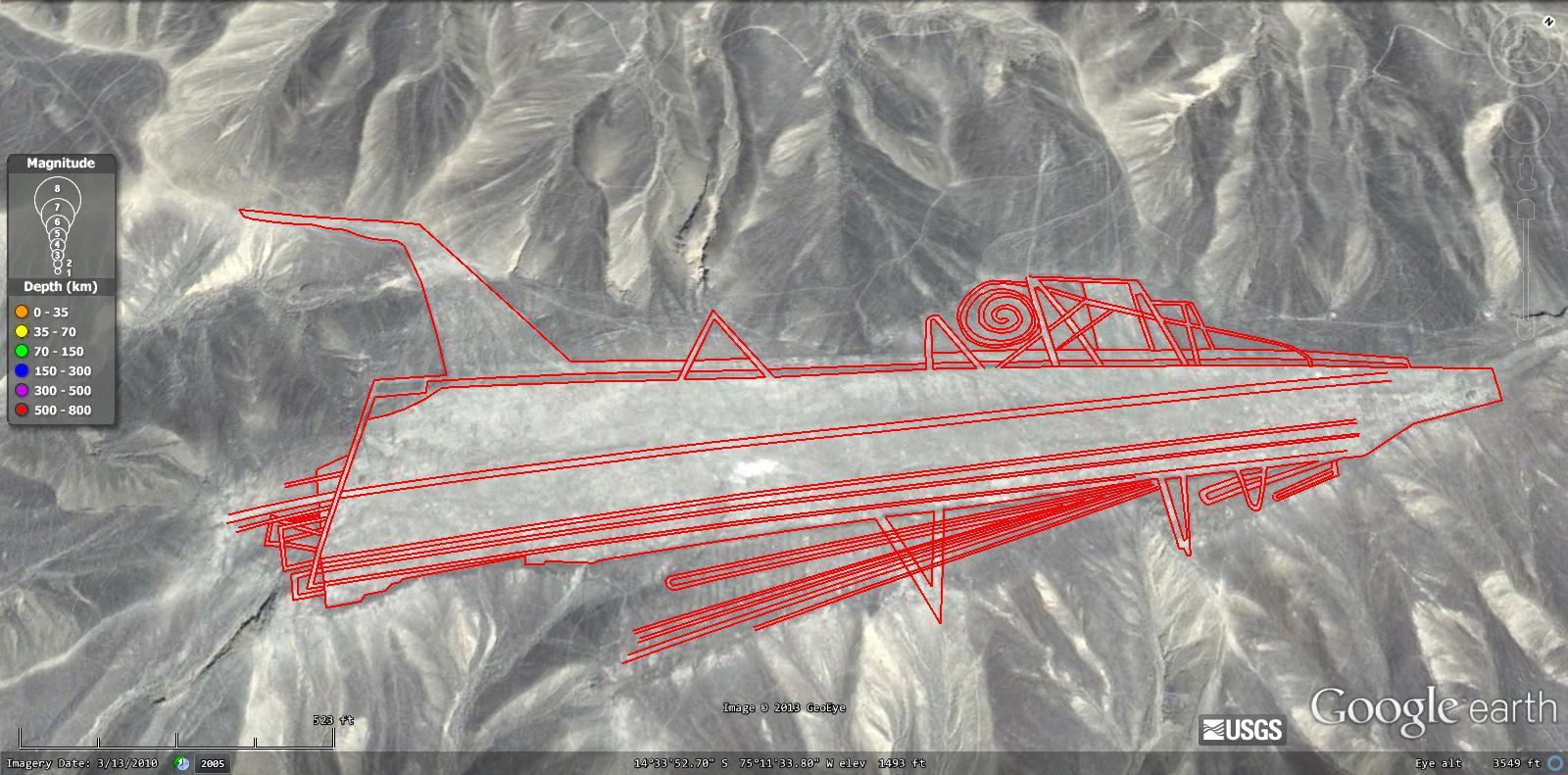
Trust me people, I know that mapping these lines in Google Earth, (not Paint, MS Art, or any other program) is not perfect but in order to see which lines go under and which go over and figuring out which line is really a line worth tracing, you need an interactive Earth viewing program. CAD is a great program but it is not practical for this use. If someone can prove me wrong on this, please do so. It would save me work.
I don't believe that we have to get every line accurate to the millionth degree. Just by zooming in and tracing carefully we can get close enough to see what this is. I'm not looking for perfection here. People can come in here and tell me that I am wasting my time or not doing it right.. I only have one thing to say to those people. I have done this on my own, on my computer for fun. Yet scientist and archaeologists don't have this information. There is no denying that my results are drastically different from anyone else's. Since we cannot just go trucking on the lines and measure ourselves, I would think this is the next best thing.
I don't purposely leave out lines. I can't magically trace them all at once. So when you look at a picture that I post... there is a pretty good chance you will see lines not traced yet.
Someone also said it is impossible to tell an old line from a new one, this is untrue. Looking at the area, if a line goes and goes...and then goes under another, just to pop up on the other side... I am guessing it is part of the design. If the line is laser straight or incorporated in the design.. my guess is, it's a line that needs to be included.
Anyone who would like to help to message me, I need all that I can get. We can come up with a date to meet in the chat room or something and come up with a game plan.
More to come, thanks for reading.
Thanks everyone, for all the comments and the ATS Live discussion. I am excited to see how many people have offered their help with this. There have been a lot of good ideas of how to tackle this and I am looking forward to seeing the results. I’m going to reply to several members in this single post.
Originally posted by grobi77
reply to post by yampa
Isn't this the "cut off" mountain top?
BTW, is there a mainstream/scientific explanation for the missing top of the mountain?
I only know the theories from Erich von Däniken and Giorgio Tsoukalos...
Does anyone have a link for me? I don't want to derail this thread...I'm just curious
Thanks in advance!

That is the same depiction as the one below. It is on a different mountain and flipped around.
I just realized that this picture was not finished and I had only half redone with outline. To show the importance of outlining as opposed to just tracing I am providing a before and after picture.
Trust me people, I know that mapping these lines in Google Earth, (not Paint, MS Art, or any other program) is not perfect but in order to see which lines go under and which go over and figuring out which line is really a line worth tracing, you need an interactive Earth viewing program. CAD is a great program but it is not practical for this use. If someone can prove me wrong on this, please do so. It would save me work.
I don't believe that we have to get every line accurate to the millionth degree. Just by zooming in and tracing carefully we can get close enough to see what this is. I'm not looking for perfection here. People can come in here and tell me that I am wasting my time or not doing it right.. I only have one thing to say to those people. I have done this on my own, on my computer for fun. Yet scientist and archaeologists don't have this information. There is no denying that my results are drastically different from anyone else's. Since we cannot just go trucking on the lines and measure ourselves, I would think this is the next best thing.
I don't purposely leave out lines. I can't magically trace them all at once. So when you look at a picture that I post... there is a pretty good chance you will see lines not traced yet.
Someone also said it is impossible to tell an old line from a new one, this is untrue. Looking at the area, if a line goes and goes...and then goes under another, just to pop up on the other side... I am guessing it is part of the design. If the line is laser straight or incorporated in the design.. my guess is, it's a line that needs to be included.
Anyone who would like to help to message me, I need all that I can get. We can come up with a date to meet in the chat room or something and come up with a game plan.
More to come, thanks for reading.
edit on 17-2-2013 by FuzzyNintendo because: (no reason given)
edit on 17-2-2013 by FuzzyNintendo because: (no reason
given)
seriously, you guys will have better luck developing a program that can plot these lol, you wont get ANYWHERE guessing since you have no idea what it
should look like lol
Originally posted by FuzzyNintendo
just wanted to point out,you seem to have missed out lines that join the triangles,
it looks in the photo as if there should be a zig zag along it
good luck and have fun
Originally posted by FuzzyNintendo
reply to post by WanderingThe3rd
I don't disagree, I may be wasting my time but since I don't have the know how to write a computer program, there is only so much I can do. Saving a screenshot of an area and opening it in another program to edit, then repeating this over hundreds of miles.. could take a while. Doing it in google allows me to connect every line and view it as a whole. It may not be super accurate but until someone else comes along with the technical knowhow, I'm stuck doing what I know. It's better than forgetting about it. This is the exact reason I came to ATS. I need someone else to help with this.
Plus I enjoy it
By doing it in Google Earth, are you then able to somehow share the work you've done with others? I know you can share photos and the like, and tag them to certain coordinates within the program. If this is possible, maybe it's a potential way to collaborate?
Originally posted by cjttatu
Originally posted by FuzzyNintendo
just wanted to point out,you seem to have missed out lines that join the triangles,
it looks in the photo as if there should be a zig zag along it
good luck and have fun
This is exactly what I am talking about.. I didn't miss the lines, I did not get to them yet because I am not a magician. This is a process. When I post a picture you will see lines that I have not outlined yet. Again, it's not because I am choosing to exclude them or I have missed them.
reply to post by Raster
I believe that if someone finds the save file where the lines in Google Earth are saved, we can copy and email.
I believe that if someone finds the save file where the lines in Google Earth are saved, we can copy and email.
Originally posted by FuzzyNintendo
reply to post by Raster
I believe that if someone finds the save file where the lines in Google Earth are saved, we can copy and email.
I think you can right-click on the name of the path you've drawn in the left-hand navigation of Google Earth, then select "Save Place As" and you can save the .KMZ file. Then you could name the file whatever you want (nazca_spaceship.kmz, for example) and share it via Dropbox, etc. with others. Then all others have to do is open it in Google Earth and it will become something that can toggle on and off. Not sure if others can add to it that way, but maybe?
Originally posted by Raster
Originally posted by FuzzyNintendo
reply to post by Raster
I believe that if someone finds the save file where the lines in Google Earth are saved, we can copy and email.
I think you can right-click on the name of the path you've drawn in the left-hand navigation of Google Earth, then select "Save Place As" and you can save the .KMZ file. Then you could name the file whatever you want (nazca_spaceship.kmz, for example) and share it via Dropbox, etc. with others. Then all others have to do is open it in Google Earth and it will become something that can toggle on and off. Not sure if others can add to it that way, but maybe?
Just tried it and confirmed that yes, you can add to existing paths and it will next the changes under the original .KMZ file. Then if you re-save the file to share with others, it will contain all of the data. What's nice it that you can turn the individual "additions" on and off if you want.
reply to post by JayinAR
I skimmed the second link provided by IndianaJoe, which you state (in the post to which I'm replying) includes complex, full site, wireframe/ 3D mapping. It doesn't. It incorporates a tiny segment of the Nazca markings, near Palpa, and offers a basic sketch outline no different to what the OP is doing (albeit properly surveyed and therefore accurate in terms of the length of the lines - though the OP in this thread cannot be far off in terms of accuracy, and it would seem that any measurement discrepancy would be negligible in terms of how it affects the final image, simply by virtue of the minimal skill needed to trace a visible line in the Google Earth program..)
Did I miss something? There didn't seem to be anything close to the quantity of imagery that's being floated in this thread. One tiny segment, mapped out, showing absolutely no cohesive imagery. Conversely, this thread covers vast areas of the Nazca region, and definitely gives the impression that there is a lot of very coherent imagery, uncannily suggestive of 3D design of a technical nature, available from intuitive interpreting of the simple line patterns.
Could you link me to the page where you saw the 'full site' mapping referred to in your post, which you claim makes the purpose of this thread redundant as it's ''already been done'' - based on the second link provided by IndianaJoe? Thanks.
reply to post by FlyInTheOintment
Here is another article regarding the mapping of the site. OP please read this article, the "star-ship glyph" you have traced is mapped and examined by the author in this article. The article is good because it just presents data and doesn't assert any grand conclusions. Article
There are literally hundred's of scholarly articles on the subject. The entire area has been mapped and surveyed, multiple times over (only recently has the area been mapped using modern day equipment, but surveying the area goes back over 70 years). By nature, scholarly research is somewhat piecemeal. There is absolutely a benefit in stepping back and looking at the big picture, which I applaud the OP for trying to do. OP should be proud of the fact he instinctively felt compelled to do something that modern day archaeologists have deemed as vital, and have themselves been engaged in for the past decade. OP your not the first person to attempt to plot all the lines, but it's very impressive that you may be the first lay person to actually attempt it, especially considering your doing it without the aid of advanced equipment, it say's a lot about your work ethic and commitment to the project.
To really understand the big picture though, you have to have a keen understanding of its component parts. To really get the big picture you need to read, dispute, test, and expand on hundred's of smaller ideas. That means reading 100's of articles on the subject and forming a testable hypothesis. That's why academic's is "hard" and Nasca still remains somewhat of a mystery. Just so everyone knows, Nasca is still a mystery, the purpose of the lines remains hotly debated. I would advise anyone interested to study up on Nasca and look beyond the monumental construction. A lot of information can be gleaned from other aspects of the culture, such as patterns on textiles and pottery, that will aid in solving the big mystery.
It is good to formulate you own hypothesis, you may be just as right as anyone else, but if you wan to be taken seriously you need to utilize the scientific method. If your going to put time into this, I beg of you, please be scientific because I actually do think, you may be on to something. I'm trying my damnedest to get a hold of the .xmap files so I can share it on here with everyone (main stream archaeologists are hesitant to share their data with a conspiracy forum, naturally). The data is publicly view-able at major research libraries. I'f you'd all like I can post more articles regarding mapping at Nasca.
edit on 18-2-2013 by IndianaJoe because: (no reason given)
edit on 18-2-2013 by
IndianaJoe because: (no reason given)
edit on 18-2-2013 by IndianaJoe because: (no reason given)
new topics
-
Sunak spinning the sickness figures
Other Current Events: 17 minutes ago -
Nearly 70% Of Americans Want Talks To End War In Ukraine
Political Issues: 28 minutes ago -
Late Night with the Devil - a really good unusual modern horror film.
Movies: 2 hours ago -
Cats Used as Live Bait to Train Ferocious Pitbulls in Illegal NYC Dogfighting
Social Issues and Civil Unrest: 3 hours ago -
The Good News According to Jesus - Episode 1
Religion, Faith, And Theology: 5 hours ago -
HORRIBLE !! Russian Soldier Drinking Own Urine To Survive In Battle
World War Three: 7 hours ago -
Bobiverse
Fantasy & Science Fiction: 10 hours ago -
Florida man's trip overseas ends in shock over $143,000 T-Mobile phone bill
Social Issues and Civil Unrest: 10 hours ago
top topics
-
Florida man's trip overseas ends in shock over $143,000 T-Mobile phone bill
Social Issues and Civil Unrest: 10 hours ago, 8 flags -
SETI chief says US has no evidence for alien technology. 'And we never have'
Aliens and UFOs: 14 hours ago, 7 flags -
Cats Used as Live Bait to Train Ferocious Pitbulls in Illegal NYC Dogfighting
Social Issues and Civil Unrest: 3 hours ago, 7 flags -
This is our Story
General Entertainment: 17 hours ago, 4 flags -
Former Labour minister Frank Field dies aged 81
People: 12 hours ago, 4 flags -
Bobiverse
Fantasy & Science Fiction: 10 hours ago, 3 flags -
Late Night with the Devil - a really good unusual modern horror film.
Movies: 2 hours ago, 2 flags -
HORRIBLE !! Russian Soldier Drinking Own Urine To Survive In Battle
World War Three: 7 hours ago, 2 flags -
The Good News According to Jesus - Episode 1
Religion, Faith, And Theology: 5 hours ago, 0 flags -
Nearly 70% Of Americans Want Talks To End War In Ukraine
Political Issues: 28 minutes ago, 0 flags
active topics
-
Breaking Baltimore, ship brings down bridge, mass casualties
Other Current Events • 481 • : firerescue -
President BIDEN Vows to Make Americans Pay More Federal Taxes in 2025 - Political Suicide.
2024 Elections • 108 • : ImagoDei -
Truth Social goes public, be careful not to lose your money
Mainstream News • 124 • : lilzazz -
British TV Presenter Refuses To Use Guest's Preferred Pronouns
Education and Media • 145 • : Annee -
Nearly 70% Of Americans Want Talks To End War In Ukraine
Political Issues • 2 • : Consvoli -
Sunak spinning the sickness figures
Other Current Events • 0 • : annonentity -
Cats Used as Live Bait to Train Ferocious Pitbulls in Illegal NYC Dogfighting
Social Issues and Civil Unrest • 9 • : ImagoDei -
Late Night with the Devil - a really good unusual modern horror film.
Movies • 3 • : Hecate666 -
HORRIBLE !! Russian Soldier Drinking Own Urine To Survive In Battle
World War Three • 23 • : Disgusted123 -
Hi folks I'm Leon Grad
Introductions • 9 • : leongrad