It looks like you're using an Ad Blocker.
Please white-list or disable AboveTopSecret.com in your ad-blocking tool.
Thank you.
Some features of ATS will be disabled while you continue to use an ad-blocker.

Why doesnt Nasa have any detailed pictures of the Moon anomally Shard?
page: 29share:
reply to post by AthlonSavage
Hey Athlon , check out these photographs .

Hey Athlon , check out these photographs .

edit on 15-2-2013 by wolveriine because: (no reason given)
reply to post by AthlonSavage
The picture was taken at sunrise. The Sun is not at 22.5º
Anaxagoras
On Earth the Sun is 22º above the horizon about 2 hours after sunrise. On the Moon it takes about 40 hours to get that high. The picture was taken at sunrise.
You also are assuming the ground is flat. Not a valid assumption on the rim of a crater. As I said before, there is no way to accurately calculate the actual height of the pile of rocks without accurately knowing both the elevation of the Sun and the slope of the ground.
For reference here is a picture of a 230 meter hill.
What is the angle of the sun because if its 22.5 degrees thats quite a tall object.
The picture was taken at sunrise. The Sun is not at 22.5º
Anaxagoras A at Sunrise
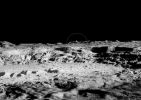
Last Tuesday, LRO's orbit was just above the lunar terminator (the day/night boundary), so huge shadows highlight topography and render many relatively normal areas of the Moon nearly unrecognizable.
Anaxagoras
On Earth the Sun is 22º above the horizon about 2 hours after sunrise. On the Moon it takes about 40 hours to get that high. The picture was taken at sunrise.
You also are assuming the ground is flat. Not a valid assumption on the rim of a crater. As I said before, there is no way to accurately calculate the actual height of the pile of rocks without accurately knowing both the elevation of the Sun and the slope of the ground.
I included a picture of towers for a visual reference.
For reference here is a picture of a 230 meter hill.
edit on 2/15/2013 by Phage because: (no reason given)
reply to post by Phage
No the assumption i made is the angle of light that is cast across the crater is the same as that casting on the tower.
I am looking at the other information in your post about the sunrise. I would like to find some information if its available that shows pictures taken on earth or moon of known objects with their shadows at different known elevations of sun. My next post therefore may not be till tommorow.
i couldnt agree more hence why the debate is moving into some interesting territory.
You also are assuming the ground is flat.
No the assumption i made is the angle of light that is cast across the crater is the same as that casting on the tower.
I am looking at the other information in your post about the sunrise. I would like to find some information if its available that shows pictures taken on earth or moon of known objects with their shadows at different known elevations of sun. My next post therefore may not be till tommorow.
As I said before, there is no way to accurately calculate the actual height of the pile of rocks without accurately knowing both the elevation of the Sun and the slope of the ground.
i couldnt agree more hence why the debate is moving into some interesting territory.
edit on 15-2-2013 by AthlonSavage because: (no reason given)
edit on 15-2-2013 by AthlonSavage because: (no reason
given)
Firstly for clarification to everybody who is a moon novice like me some basic fundamentals about the moon Latitude and Longitude coordinate system;
and the location of Anaxagoras crater on the moon and its coordinate position.
The moon cooridnate system (see diagram) below only shows the visible side of the moon as viewed from earth.The coordinate system of the moon is a view of its surface as it appears directly facing the earth. The darkside of the moon which never faces the earth is not apart of the coordinate system shown in the diagram below.

Moon Sunrise from a laymans definition simply is referring to the extreme tips of latitude or longitide coordinate locations where the moons bright side joins with the darkside of the moon. Remember the moon doesnt rotate like the earth so sunrise is referring to the the outermost coodinates that are nearing entry into the darkside (which is never viewable from earth).
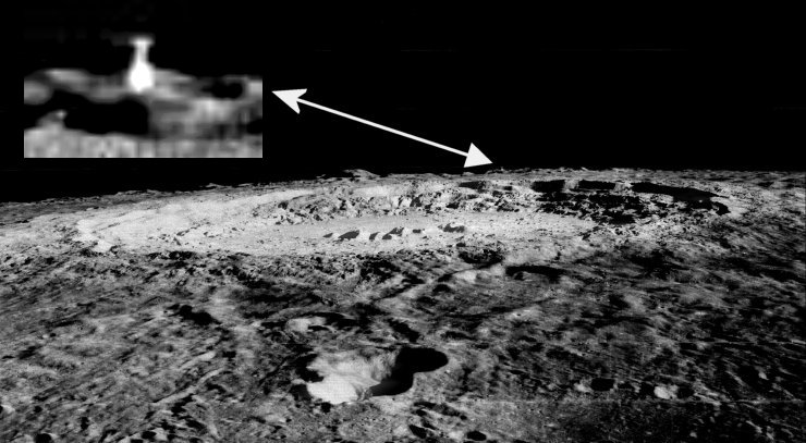
The coordinate position of Anaxagoras crater, can be found on Wiki by googling name of Anaxagoras crater. I have included a screen shot below which has a window scrollable feature, so scroll right to see the following details.
The details provide in the link are sun elevation is at 11° sunrise at Anaxagoras crater and Its coordinate position is 73.4°N 10.1°W. So as you can see its very close to the north horizion which disspears into dark.

Therefore knowing the sun elevation 11 degrees and also the tower shadow length of 375 metres allows using trigonometry for calculating the tower height to be 73 meters.
To give perspective to the height of 73 metres it would be like cutting in half a picture of the Twintowers of Deutsche Bank Headquarter in Frankfurt which each rise to 155 metres. I included a picture of the shortened tower lengths for a visual reference which i have cut down by more than half original length.

Refer to Page 28 of this thread where i posted a picture of their full height.
Looking down at top of the tower ( refer to picture of the anomally below) and around its immediate area of position i dont see any characteristics to indicate the thing is leaning or is located on part of the lunar surface which is iregular in angle with that surface around it (except for crater rims). If there was any possible deviation it might be arguable that the thing looks to be sitting based in a shallow crater. Even if true its of no significance as this would only have the effect of reducing its real height compared with the length of the shadow. Therefore the calculation of 73metres is quite conservative as an error to correct for true height of the lunar surface would only result in calculating a longer height for the anomally tower. Never the less im happy to work with 73 metres.
Therefore I dont see ground angle as having an significant bearing in assessment of this anomalies height, the significant factors to accurately determing its height are the angle of sun at its coordinate location; and also being able to make an accurate measurment of its shadow length which was achieveable because we have an accurate LRO source specifying the metres per pixel data for the image (LRO orignal picture taken of the rim of the Anaxagoras crater)
Now the last thing is the width of the tower. I have made an esitnate of the tower width based on knowing the length of the shadow. The picture below is a zoom in on the anomally and the red horizontal line indicates the length of the Tower shadow and the green vertical line its width, which i estimate to be close to 53 metres.

Posters and readers of this thread compare these dimensions (73 metre high by 53 metres wide) with the similar area dimensions taken up by twin towers in the picture above. Do you think this is pile of rocks on the moon or something more worth investigating by Nasa?
I should just note for any readers who came straight to the end of this thread this particular tower is not the Shard but another smaller height tower anomally which somebody identfied at the edge of the Anaxagoras crater.
The moon cooridnate system (see diagram) below only shows the visible side of the moon as viewed from earth.The coordinate system of the moon is a view of its surface as it appears directly facing the earth. The darkside of the moon which never faces the earth is not apart of the coordinate system shown in the diagram below.
Moon Sunrise from a laymans definition simply is referring to the extreme tips of latitude or longitide coordinate locations where the moons bright side joins with the darkside of the moon. Remember the moon doesnt rotate like the earth so sunrise is referring to the the outermost coodinates that are nearing entry into the darkside (which is never viewable from earth).
The coordinate position of Anaxagoras crater, can be found on Wiki by googling name of Anaxagoras crater. I have included a screen shot below which has a window scrollable feature, so scroll right to see the following details.
The details provide in the link are sun elevation is at 11° sunrise at Anaxagoras crater and Its coordinate position is 73.4°N 10.1°W. So as you can see its very close to the north horizion which disspears into dark.
Therefore knowing the sun elevation 11 degrees and also the tower shadow length of 375 metres allows using trigonometry for calculating the tower height to be 73 meters.
To give perspective to the height of 73 metres it would be like cutting in half a picture of the Twintowers of Deutsche Bank Headquarter in Frankfurt which each rise to 155 metres. I included a picture of the shortened tower lengths for a visual reference which i have cut down by more than half original length.
Refer to Page 28 of this thread where i posted a picture of their full height.
Looking down at top of the tower ( refer to picture of the anomally below) and around its immediate area of position i dont see any characteristics to indicate the thing is leaning or is located on part of the lunar surface which is iregular in angle with that surface around it (except for crater rims). If there was any possible deviation it might be arguable that the thing looks to be sitting based in a shallow crater. Even if true its of no significance as this would only have the effect of reducing its real height compared with the length of the shadow. Therefore the calculation of 73metres is quite conservative as an error to correct for true height of the lunar surface would only result in calculating a longer height for the anomally tower. Never the less im happy to work with 73 metres.
Therefore I dont see ground angle as having an significant bearing in assessment of this anomalies height, the significant factors to accurately determing its height are the angle of sun at its coordinate location; and also being able to make an accurate measurment of its shadow length which was achieveable because we have an accurate LRO source specifying the metres per pixel data for the image (LRO orignal picture taken of the rim of the Anaxagoras crater)
Now the last thing is the width of the tower. I have made an esitnate of the tower width based on knowing the length of the shadow. The picture below is a zoom in on the anomally and the red horizontal line indicates the length of the Tower shadow and the green vertical line its width, which i estimate to be close to 53 metres.
Posters and readers of this thread compare these dimensions (73 metre high by 53 metres wide) with the similar area dimensions taken up by twin towers in the picture above. Do you think this is pile of rocks on the moon or something more worth investigating by Nasa?
I should just note for any readers who came straight to the end of this thread this particular tower is not the Shard but another smaller height tower anomally which somebody identfied at the edge of the Anaxagoras crater.
edit on 15-2-2013 by AthlonSavage because: (no reason given)
reply to post by Phage
The angle is 11 degrees i managed to find a source reference for the sun angle elevation at the crater in question. Refer to my above post for details.
The picture was taken at sunrise. The Sun is not at 22.5º
The angle is 11 degrees i managed to find a source reference for the sun angle elevation at the crater in question. Refer to my above post for details.
The following is my opinion as a member participating in this discussion.
Originally posted by AthlonSavage
Therefore I dont see ground angle as having an significant bearing in assessment of this anomalies height, the significant factors to accurately determing its height are the angle of sun at its coordinate location; and also being able to make an accurate measurment of its shadow length which was achieveable because we have an accurate LRO source specifying the metres per pixel data for the image (LRO orignal picture taken of the rim of the Anaxagoras crater)
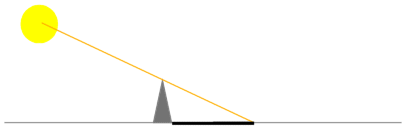
Ground angle is as important as the Sun angle, as I will try to explain in the following images.
First, a horizontal ground, with a tower casting a shadow on it.
Now, keeping the same exact positions between the Sun and the tower, but with the ground sloped to one side, we can see that the shadow would be smaller.
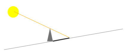
But if the slope is in the opposite direction then the shadow will look longer.
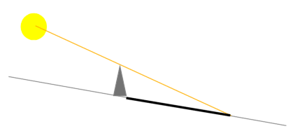
To keep things exactly the same (except the "ground") in all images I didn't even changed the size of the "tower" to make it touch the "ground".
I hope that helps.
As an ATS Staff Member, I will not moderate in threads such as this where I have participated as a member.
Nice diagrams ArMap. Shows the effect of slope on shadow length perfectly. By any chance, do you know the copyright status on those diagrams? I'd
like to see if I can use them in my blog post.
reply to post by AthlonSavage
No they don't. Use your brain. What does "sunrise" mean? Sunrise is when the Sun comes over the horizon. You know, like when you watch the sunrise and the Sun comes over the horizon?
Colongitude is an expression of the longitude at which the terminator lies, it is not the elevation of the Sun above the horizon. At Anaxagoras the Sun rises when the colongitude is 11º (and it's elevation is 0.1º, give or take)
The picture of Anaxagoras was taken at local sunrise. The shadows are very long.
The details provide in the link are sun elevation is at 11° sunrise at Anaxagoras
No they don't. Use your brain. What does "sunrise" mean? Sunrise is when the Sun comes over the horizon. You know, like when you watch the sunrise and the Sun comes over the horizon?
Colongitude is an expression of the longitude at which the terminator lies, it is not the elevation of the Sun above the horizon. At Anaxagoras the Sun rises when the colongitude is 11º (and it's elevation is 0.1º, give or take)
the-moon.wikispaces.com...
Numerically, the colongitude is equal to the longitude at which the "morning terminator" (the theoretical line of sunrise on the Moon) crosses the Moon's equator measured west from the Moon's central meridian (the line of zero longitude) on a scale of 0 to 360°.
The picture of Anaxagoras was taken at local sunrise. The shadows are very long.
edit on 2/15/2013 by Phage because: (no reason given)
The following is my opinion as a member participating in this discussion.
reply to post by PINGi14
Thanks.
Everything in ATS is governed by an "Attribution - NonCommercial - NoDerivs 3.0 Unported" Creative Commons Deed, as it says on the Terms and Conditions of use, so anyone can "share, distribute, copy, and transmit the work Users find on TAN websites provided Users provide proper attribution that includes the name of the Website User, the name of the Website, and a link to the content thread."
As an ATS Staff Member, I will not moderate in threads such as this where I have participated as a member.
reply to post by Phage
I do use my brain Phage thats why i dont take any posters informaion at face value. For exampe, You have been wrong about the direction of the Shard shadow. I have collaborating proof that i was correct for the direction of the sun is illuminating in the shard picture.
The collaboration comes from a group who are creating a Moon picture media tool that allows a person to insert a moon surface picture and it calculates the sun angle and also the direction of illumination. The link to webpage is attached and also i have included a image from site that can be compared directly to the discussion i provided on the direction of the sun in the shard picture. So your obviously not always right and therefore i do my homework by using my brain.
cosmoquest.org...:_Lighting_Effects_Guide

I know the coordinates of Apollo 11 Mare Tranquillitatis Lunar Landing Time 4:17:40 p.m. EDT, July 20, 1969. Landing Site Coordinates 0.67408° N latitude, 23.47297° E longitude, the sun angle is document between 13 and 15 degrees. There is no doubt a way of performing a mathematical calculation to work out the sun angle at the Apollo position. Because we know the actual sun angle at the Apollo 11 landing site, this allows for verifying the calculation. Then use the calculation at the lat/long coordinations of where the anomally sits. This is what my brain will be up to next to work it out using maths.
No they don't. Use your brain. What does "sunrise" mean? Sunrise is when the Sun comes over the horizon. You know, like when you watch the sunrise and the Sun comes over the horizon?
I do use my brain Phage thats why i dont take any posters informaion at face value. For exampe, You have been wrong about the direction of the Shard shadow. I have collaborating proof that i was correct for the direction of the sun is illuminating in the shard picture.
The collaboration comes from a group who are creating a Moon picture media tool that allows a person to insert a moon surface picture and it calculates the sun angle and also the direction of illumination. The link to webpage is attached and also i have included a image from site that can be compared directly to the discussion i provided on the direction of the sun in the shard picture. So your obviously not always right and therefore i do my homework by using my brain.
cosmoquest.org...:_Lighting_Effects_Guide
I know the coordinates of Apollo 11 Mare Tranquillitatis Lunar Landing Time 4:17:40 p.m. EDT, July 20, 1969. Landing Site Coordinates 0.67408° N latitude, 23.47297° E longitude, the sun angle is document between 13 and 15 degrees. There is no doubt a way of performing a mathematical calculation to work out the sun angle at the Apollo position. Because we know the actual sun angle at the Apollo 11 landing site, this allows for verifying the calculation. Then use the calculation at the lat/long coordinations of where the anomally sits. This is what my brain will be up to next to work it out using maths.
edit on 15-2-2013 by AthlonSavage because: (no reason given)
reply to post by AthlonSavage
That's great, but all the illumination information is already provided for the Lunar Orbiter image. It is also obvious. There is no need to refer to the LROC image and make further calculations but go ahead. But please be sure to take in consideration the latitude and longitude as well as the time of the lunar day at which the images were taken.
You said that the elevation of the sun at sunrise at Anaxagoras was 11º above the horizon. Don't you understand that makes no sense?
No, you don't. Unless you can explain what was illuminating the "shard" from the south instead of the east where the Sun was.
For exampe, You have been wrong about the direction of the Shard shadow. I have collaborating proof that i was correct for the direction of the sun is illuminating in the shard picture.
Because we know the actual sun angle at the Apollo 11 landing site, this allows for verifying the calculation. Then use the calculation at the lat/long coordinations of where the anomally sits.
That's great, but all the illumination information is already provided for the Lunar Orbiter image. It is also obvious. There is no need to refer to the LROC image and make further calculations but go ahead. But please be sure to take in consideration the latitude and longitude as well as the time of the lunar day at which the images were taken.
You said that the elevation of the sun at sunrise at Anaxagoras was 11º above the horizon. Don't you understand that makes no sense?
edit on 2/15/2013 by Phage because: (no reason given)
The following is my opinion as a member participating in this discussion.
Originally posted by AthlonSavage
Moon Sunrise from a laymans definition simply is referring to the extreme tips of latitude or longitide coordinate locations where the moons bright side joins with the darkside of the moon. Remember the moon doesnt rotate like the earth so sunrise is referring to the the outermost coodinates that are nearing entry into the darkside (which is never viewable from earth).
Sorry, I'm confused by that explanation. Do you mean that the sunrise refers to boundary between the dark side (or more correctly, the far side) and the side facing the Earth?
Therefore I dont see ground angle as having an significant bearing in assessment of this anomalies height, the significant factors to accurately determing its height are the angle of sun at its coordinate location; and also being able to make an accurate measurment of its shadow length which was achieveable because we have an accurate LRO source specifying the metres per pixel data for the image (LRO orignal picture taken of the rim of the Anaxagoras crater)
The coordinate location is irrelevant to get an idea of the height, you only need the Sun height (if you assume a horizontal ground), as the position on the Moon (if I understand it right) only makes a difference to how high the Sun can go in the sky, so it would mean that the location could only affect how short the shadow could be at noon, which is irrelevant to know the height of something by measuring it's shadow.
I went looking for more information about it (I know that they usually have the position of the Sun as one of the parameters of the photo), and this is what I could find about photo "nacl00000141".
Resolution: 1.807
Emission angle: 1.80
Incidence angle: 89.52
The emission angle is "the angle between the spacecraft and a vector drawn perpendicular to the planet's surface (surface normal)", so a lower value means that the satellite was closer to be vertically above the centre of the target. In this case, with an angle of 1.80º it means that it was almost vertically above it's target.
The incidence angle is "the angle between the sun and the surface normal", so a low value means that the Sun was almost vertically above the target of the photo, a high value means that the Sun was low in the sky. In this case the incidence angle was 89.52, meaning that the Sun was 0.48º above the real (not the apparent) horizon.
Using Photoshop I got a shadow length of 522.3 metres.

Now, if the Sun was 0.48º above the horizon, a little trigonometry gives us a height of 4.37 metres.
Now the last thing is the width of the tower. I have made an esitnate of the tower width based on knowing the length of the shadow. The picture below is a zoom in on the anomally and the red horizontal line indicates the length of the Tower shadow and the green vertical line its width, which i estimate to be close to 53 metres.
Photoshop gives me a similar result, so it looks like you got this measuring business right.
Posters and readers of this thread compare these dimensions (73 metre high by 53 metres wide) with the similar area dimensions taken up by twin towers in the picture above. Do you think this is pile of rocks on the moon or something more worth investigating by Nasa?
73 metres high by 53 metres wide is a big pile of rocks, but my calculations above tell me that's a 4 or 5 metres high by 53 wide pile of rocks, and that's not unusual.
As an ATS Staff Member, I will not moderate in threads such as this where I have participated as a member.
reply to post by ArMaP
Can you provide that source? (for future reference)
Where did you get the img version?
I went looking for more information about it (I know that they usually have the position of the Sun as one of the parameters of the photo), and this is what I could find about photo "nacl00000141".
Can you provide that source? (for future reference)
Where did you get the img version?
edit on 2/15/2013 by Phage because: (no reason given)
edit on 2/15/2013 by Phage because:
(no reason given)
reply to post by Phage
No you were wrong about the direction of incident light from sun. Its not coming from the upper right of shard image. This is your quote to a poster on page 20.
Its up to readers now to decide who arguments yours or mine are correct on the shadow. The pages of this discussion in thread covering direction of sun light in the shard photo are are 29, 25, 20, 21, 22.
Yeh like you always are making perfect sense. Please the road to the truth doesnt have to make perfect sense its the final facts presented that allow verification of the correct answer that matters.
Everthing is obvious to people who are only right best half the time.
No you were wrong about the direction of incident light from sun. Its not coming from the upper right of shard image. This is your quote to a poster on page 20.
Note the "incident angle" in the description of the image. That is the direction of the sunlight relative to the surface and the spacecraft. It is 80º. That is from the upper right of the unrotated image. It is not consistent with the "shadow".
Its up to readers now to decide who arguments yours or mine are correct on the shadow. The pages of this discussion in thread covering direction of sun light in the shard photo are are 29, 25, 20, 21, 22.
You said that the elevation of the sun at sunrise at Anaxagoras was 11º above the horizon. Don't you understand that makes no sense?
Yeh like you always are making perfect sense. Please the road to the truth doesnt have to make perfect sense its the final facts presented that allow verification of the correct answer that matters.
That's great, but all the illumination information is already provided for the Lunar Orbiter image. It is also obvious. There is no need to refer to the LROC image and make further calculations but go ahead. But please be sure to take in consideration the latitude and longitude as well as the time of the lunar day at which the images were taken.
Everthing is obvious to people who are only right best half the time.
reply to post by AthlonSavage
Yes, I corrected myself when my error was pointed out to me. The proper datum to use was the azimuth, 91º. The light is coming from the right.
No you were wrong about the direction of incident light from sun. Its not coming from the upper right of shard image. This is your quote to a poster on page 20.
True. But it's also up to you to explain how the "shard" could be illuminated from the south.
Its up to readers now to decide who arguments yours or mine are correct on the shadow.
I could argue with your statistics but even 50% is better than seldom.
Everthing is obvious to people who are only right best half the time.
edit on 2/15/2013 by Phage because: (no reason given)
reply to post by Phage
The moon mappers as i explained in a couple of posts above for explanations for lighting directoon on moon supports my argument where light is coming from left of the picture. We can leave it to the readers to decide they have all the page numbers i listed above to find the discussion of shadow.
I hope and encourage readers to go over the discussion on shadow and provide their opinion
Yes i guess it will come down to me as i can see your shadow data hasnt been very convincing.
Nice generalisation for a layman but it wont wash in discussion which requires a higher level of rigour to uncover the facts.
Yes, I corrected myself when my error was pointed out to me. The proper datum to use was the azimuth, 91º. The light is coming from the right.
The moon mappers as i explained in a couple of posts above for explanations for lighting directoon on moon supports my argument where light is coming from left of the picture. We can leave it to the readers to decide they have all the page numbers i listed above to find the discussion of shadow.
I hope and encourage readers to go over the discussion on shadow and provide their opinion
True. But it's also up to you to explain how the "shard" could be illuminated from the south.
Yes i guess it will come down to me as i can see your shadow data hasnt been very convincing.
I could argue with your statistics but even 50% is better than seldom.
Nice generalisation for a layman but it wont wash in discussion which requires a higher level of rigour to uncover the facts.
reply to post by AthlonSavage
You explained nothing when you were talking about that. You verified nothing and the data for the Lunar Orbiter image says the lighting was from the right as do the craters.
The moon mappers as i explained in a couple of posts above for explanations for lighting directoon on moon supports my argument where light is coming from left of the picture.
I'm all ears. How was the "shard" illuminated from the south. What was the source of illumination?
Yes i guess it will come down to me as i can see your shadow data hasnt been very convincing.
edit on 2/15/2013 by Phage because: (no reason given)
reply to post by Phage
The pictures Lunar Orbiter III in 1967 (Frame Number LO-III-84M) are in the first few pages of the thread. The lighting and location details are speculative that ways we are discussing them in this thread. As i said already Phage the readers have the page numbers for the shadow dicussion let them read through it and contribute opinions, after all this is what the purpose of creating a thread to listen to multiple opinions from members.
I will get back to that later as im expecting members will read through the thread shadow dicussions and have some ideas for that, which might be a reasonable 50% believable answer.
You explained nothing when you were talking about that. You verified nothing and the data for the Lunar Orbiter image says the lighting was from the right as do the craters.
The pictures Lunar Orbiter III in 1967 (Frame Number LO-III-84M) are in the first few pages of the thread. The lighting and location details are speculative that ways we are discussing them in this thread. As i said already Phage the readers have the page numbers for the shadow dicussion let them read through it and contribute opinions, after all this is what the purpose of creating a thread to listen to multiple opinions from members.
I'm all ears. How was the "shard" illuminated from the south. What was the source of illumination?
I will get back to that later as im expecting members will read through the thread shadow dicussions and have some ideas for that, which might be a reasonable 50% believable answer.
edit on 15-2-2013 by AthlonSavage because: (no reason given)
The following is my opinion as a member participating in this discussion.
Originally posted by Phage
Can you provide that source? (for future reference)
Sure.
Here you can find a file called "INDEX.TAB" (or a file called "CUMINDEX.TAB", that's the cumulative index, but as this is the first volume it's the same as the normal "INDEX.TAB"). That file has a comma separated file with all the images included in that volume.
In the same directory/folder you can see a file called "INDEX.LBL" (and a "CUMINDEX.LBL"). That file has a description of all the fields in the comma separated file.
I made a small program that takes those two files and creates a database that's easy to search, so I did that and looked for image "nacl00000141" on the field "ORIGINAL_PRODUCT_ID". It corresponds to image "M101017141LE". Part of the data for that image is shown below.
VOLUME_ID LROLRC_0001
FILE_SPECIFICATION_NAME LRO-L-LROC-2-EDR-V1.0/LROLRC_0001/DATA/COM/2009181/NAC/M101017141LE.IMG
INSTRUMENT_HOST_ID LRO
INSTRUMENT_ID LROC
ORIGINAL_PRODUCT_ID nacl00000141
PRODUCT_ID M101017141LE
PRODUCT_VERSION_ID v1.4
TARGET_NAME MOON
ORBIT_NUMBER 73
SLEW_ANGLE 0.011
MISSION_PHASE_NAME COMMISSIONING
RATIONALE_DESC TARGET OF OPPORTUNITY
DATA_QUALITY_ID 0
NAC_PREROLL_START_TIME 2009-06-30 16:04:33.695
START_TIME 2009-06-30 16:04:34.973
STOP_TIME 2009-06-30 16:04:41.361
...
...
...
IMAGE_LINES 5120
LINE_SAMPLES 5064
SAMPLE_BITS 8
SCALED_PIXEL_WIDTH 1.86
SCALED_PIXEL_HEIGHT 1.75
RESOLUTION 1.807
EMMISSION_ANGLE 1.80
INCIDENCE_ANGLE 89.52
PHASE_ANGLE 91.32
NORTH_AZIMUTH 269.06
SUB_SOLAR_AZIMUTH 179.13
SUB_SOLAR_LATITUDE 0.59
SUB_SOLAR_LONGITUDE 82.55
SUB_SPACECRAFT_LATITUDE 72.24
SUB_SPACECRAFT_LONGITUDE 351.73
SOLAR_DISTANCE 152184781.5
SOLAR_LONGITUDE 157.30
CENTER_LATITUDE 72.25
CENTER_LONGITUDE 352.30
UPPER_RIGHT_LATITUDE 72.10
UPPER_RIGHT_LONGITUDE 351.81
LOWER_RIGHT_LATITUDE 72.40
LOWER_RIGHT_LONGITUDE 351.78
LOWER_LEFT_LATITUDE 72.40
LOWER_LEFT_LONGITUDE 352.79
UPPER_LEFT_LATITUDE 72.10
UPPER_LEFT_LONGITUDE 352.81
SPACECRAFT_ALTITUDE 185.64
TARGET_CENTER_DISTANCE 1923.10
ORBIT_NODE A
LRO_FLIGHT_DIRECTION -X
You can get the IMG file here.
As an ATS Staff Member, I will not moderate in threads such as this where I have participated as a member.
reply to post by AthlonSavage
No. The lighting is not speculative. The parameters are provided with the image. Perhaps you can tell us which of those parameters indicates the lighting was from the left.
The location is somewhat speculative but the general area has been known by using identifiable landmarks. Saint Exupery did an excellent job of refining the location. Have you reviewed his work? He seems to have a deep familiarity with the terrain.
The lighting and location details are speculative that ways we are discussing them in this thread.
No. The lighting is not speculative. The parameters are provided with the image. Perhaps you can tell us which of those parameters indicates the lighting was from the left.
The location is somewhat speculative but the general area has been known by using identifiable landmarks. Saint Exupery did an excellent job of refining the location. Have you reviewed his work? He seems to have a deep familiarity with the terrain.
new topics
-
This is our Story
General Entertainment: 1 hours ago -
President BIDEN Vows to Make Americans Pay More Federal Taxes in 2025 - Political Suicide.
2024 Elections: 3 hours ago -
Ode to Artemis
General Chit Chat: 4 hours ago -
Ditching physical money
History: 8 hours ago -
One Flame Throwing Robot Dog for Christmas Please!
Weaponry: 8 hours ago -
Don't take advantage of people just because it seems easy it will backfire
Rant: 8 hours ago -
VirginOfGrand says hello
Introductions: 9 hours ago -
Should Biden Replace Harris With AOC On the 2024 Democrat Ticket?
2024 Elections: 9 hours ago
top topics
-
University student disciplined after saying veganism is wrong and gender fluidity is stupid
Education and Media: 12 hours ago, 12 flags -
Police clash with St George’s Day protesters at central London rally
Social Issues and Civil Unrest: 15 hours ago, 9 flags -
President BIDEN Vows to Make Americans Pay More Federal Taxes in 2025 - Political Suicide.
2024 Elections: 3 hours ago, 8 flags -
TLDR post about ATS and why I love it and hope we all stay together somewhere
General Chit Chat: 16 hours ago, 7 flags -
Should Biden Replace Harris With AOC On the 2024 Democrat Ticket?
2024 Elections: 9 hours ago, 6 flags -
Don't take advantage of people just because it seems easy it will backfire
Rant: 8 hours ago, 4 flags -
One Flame Throwing Robot Dog for Christmas Please!
Weaponry: 8 hours ago, 4 flags -
God lived as a Devil Dog.
Short Stories: 13 hours ago, 3 flags -
Ditching physical money
History: 8 hours ago, 3 flags -
VirginOfGrand says hello
Introductions: 9 hours ago, 2 flags
active topics
-
Tucker Carlson UFOs are piloted by spiritual entities with bases under the ocean and the ground
Aliens and UFOs • 42 • : Jukiodone -
The Fight for Election Integrity Continues -- Audits, Criminal Investigations, Legislative Reform
2024 Elections • 4143 • : Station27 -
-@TH3WH17ERABB17- -Q- ---TIME TO SHOW THE WORLD--- -Part- --44--
Dissecting Disinformation • 636 • : F2d5thCavv2 -
Russia Ukraine Update Thread - part 3
World War Three • 5719 • : F2d5thCavv2 -
Who guards the guards
US Political Madness • 5 • : 19Bones79 -
One Flame Throwing Robot Dog for Christmas Please!
Weaponry • 6 • : BeTheGoddess2 -
Police clash with St George’s Day protesters at central London rally
Social Issues and Civil Unrest • 37 • : SprocketUK -
New whistleblower Jason Sands speaks on Twitter Spaces last night.
Aliens and UFOs • 48 • : baablacksheep1 -
Hate makes for strange bedfellows
US Political Madness • 40 • : 19Bones79 -
Lawsuit Seeks to ‘Ban the Jab’ in Florida
Diseases and Pandemics • 29 • : Cre8chaos79