It looks like you're using an Ad Blocker.
Please white-list or disable AboveTopSecret.com in your ad-blocking tool.
Thank you.
Some features of ATS will be disabled while you continue to use an ad-blocker.

Confounding Sequence of Big Quakes Rattle Santa Cruz Islands
page: 9share:
reply to post by Olivine
Umm, Olivine, I have already assessed available telemetry for the area, and have already questioned in a previous post WHY the USGS is not using SANVU in their phase data for these quakes, as it is the closest active station to the activity- that I know of. Now unless someone else would care to prove me incorrect on that, and unless someone else would care to spend the kind of time I am spending looking at real time spectrograms, not just webicorder plots, of incoming data from that closest station, then I stand by my statements. I have no idea why you are looking at data that is coming from a station over 200 km further away, down in the Loyalty Islands.
And oh yeah, thanks much for that map and article about the deep melt.
reply to post by TrueAmerican
Oh, I don't know, I guess I just like have 3 stations open, from 3 different azimuths to watch the activity.
I thought you may find that map & article of some interest.
Just out of curiosity, how are the spectrographs more helpful than the waveforms, at these monitoring distances? Are you just more familar with the data in that form?
EDIT: (in response to post below this one) Thanks, TA. I've had Espiritu Santo, Vanuatu (Sanvu) open for a few days.
Oh, I don't know, I guess I just like have 3 stations open, from 3 different azimuths to watch the activity.
I thought you may find that map & article of some interest.
Just out of curiosity, how are the spectrographs more helpful than the waveforms, at these monitoring distances? Are you just more familar with the data in that form?
edit on 2/9/2013 by Olivine because: to ask a question
EDIT: (in response to post below this one) Thanks, TA. I've had Espiritu Santo, Vanuatu (Sanvu) open for a few days.
edit on 2/9/2013 by
Olivine because: (no reason given)
reply to post by Olivine
Well yes, of course it is very interesting to me. As to Sanvu, it is on the G network, which you can of course pull up in GEE- or any other program for that matter that can source real time data from the IDMC. I highly suggest you pull that station up...
That region of deep melt, even as deep as it is, is essentially another discovered hotspot. And it makes suspect all activity above it or near it. Melt can melt rock above it. If a sizable portion was to find its way towards the surface in a viable conduit, and if that conduit came into contact with water, steam pressure is of concern, as well as the magma itself.
In all honesty I have not seen anything resembling tremor from 500 km away, except for these certain signatures I keep getting where the onset is visible, and the rest is cut away. And they have me perplexed. We need closer seismos, for sure.
Originally posted by Olivine
Just out of curiosity, how are the spectrographs more helpful than the waveforms, at these monitoring distances? Are you just more familar with the data in that form?
In several ways:
1) You can see frequency content.
2) This is critical in helping to decide if something is a seismic event, and particularly with low magnitude events that don't propagate far- like to another station.
3) In this case where we are 500 km away from the situation, all the more handy, and indispensable, to me.
4) You can see things that can get otherwise completely hidden when you are looking at waveform view, cause the power of the event may be too close in amplitude to the background noise floor. This is especially true where there has just been an event, and then there is another smaller one. With dynamic scales, like in GEE, you'd never see the second one until the first one's off the screen. If they are too close, you probably won't see it at all.
5) Also, you can see the separate P & S waves clearly, and more distinctly in spectro mode..
6) And also, forgot, spectro is extremely useful for spotting teleseisms from distant quakes- those get hidden all the time in waveform view.
There is a ton of low level seismicity happening in Santa Cruz, showing at SANVU, and has been since this started.
And btw, just had another 6.5.
edit on Sat Feb 9th 2013 by TrueAmerican because: (no reason given)
edit on Sat Feb 9th 2013 by
TrueAmerican because: (no reason given)
reply to post by TrueAmerican
Tons of great info....keep it coming!!
I've had GEE on non-stop since the 8.0 (not watching the whole time ofcourse), so I'm starting to get a bit of an idea of patterns, regular leverl noise, etc...
I will admit to not reading this whole thread, so apologize if this is really redundant....but TA, are you seeing some wierd stuff? I just get the impression we are watching several different mechanisms at play here. I think some of them are becoming a bit more stand-outish as time goes by,....but.....there's just something at work here that is odd.
ETA: In light of what I just wrote, this article is very, very interesting: Friday Focal Mechanisms
I think that this is what I am seeing. While I am not trained to understand what I'm looking at, I can still see that there is a mixture of distinct, different patterns.
Tons of great info....keep it coming!!
I've had GEE on non-stop since the 8.0 (not watching the whole time ofcourse), so I'm starting to get a bit of an idea of patterns, regular leverl noise, etc...
I will admit to not reading this whole thread, so apologize if this is really redundant....but TA, are you seeing some wierd stuff? I just get the impression we are watching several different mechanisms at play here. I think some of them are becoming a bit more stand-outish as time goes by,....but.....there's just something at work here that is odd.
ETA: In light of what I just wrote, this article is very, very interesting: Friday Focal Mechanisms
The aftershocks are turning out to be a bit of a surprise. Of the nine aftershocks stronger than magnitude 6 recorded so far, not one of them is compressional: instead we’re seeing a mixture of extensional and strike-slip faulting.
I think that this is what I am seeing. While I am not trained to understand what I'm looking at, I can still see that there is a mixture of distinct, different patterns.
edit on 9-2-2013 by westcoast because: (no reason given)
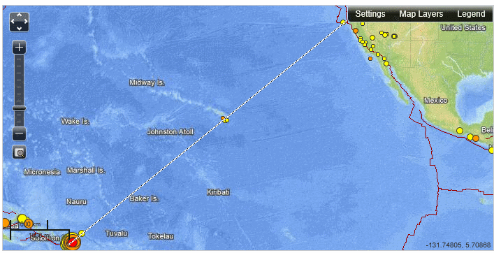
I don't know if this theory is still alive, but it looks like the recent 6.5 as well as the 5+ before it are in the straight line that was discussed
a page or so back.
reply to post by westcoast
Yes interesting article, thanks.
From that article:
Nope not a thing. In fact, I just made this thread on a whim, out of the clear blue sky. Nothing was wrong. Nope, not a thing.
THE WHOLE PREMISE OF THIS THREAD was based on the fact that I spotted these foreshocks that were too close in magnitude, and out of the norm BEFORE that 8.0 hit! Sheesh.
:shk:
Umm, sorry pal (to the author of that article), but I disagree, and this thread is my rebuttal. There was that evidence, no doubt. As to the rest of the article though, yes, very interesting. The question is, what does it all mean?
Yes interesting article, thanks.
From that article:
As ever, you should be aware that there was nothing about these earthquakes that told us this beforehand.
Nope not a thing. In fact, I just made this thread on a whim, out of the clear blue sky. Nothing was wrong. Nope, not a thing.
THE WHOLE PREMISE OF THIS THREAD was based on the fact that I spotted these foreshocks that were too close in magnitude, and out of the norm BEFORE that 8.0 hit! Sheesh.
:shk:
Umm, sorry pal (to the author of that article), but I disagree, and this thread is my rebuttal. There was that evidence, no doubt. As to the rest of the article though, yes, very interesting. The question is, what does it all mean?
I meant to star/flag this earlier, but i always forget my password. Very impressive that you picked up on some unusual activity before the 8.0.
Another 6.6 just happened a little bit ago. They just keep coming.
Another 6.6 just happened a little bit ago. They just keep coming.
reply to post by TrueAmerican
Another question on this line of quakes, someone said it goes through Hawaii if you continue it.
Where does it go from there?
There was a shake in Colorado and then eastern Canada, Cookshire Eaton, Canada.
Another question on this line of quakes, someone said it goes through Hawaii if you continue it.
Where does it go from there?
There was a shake in Colorado and then eastern Canada, Cookshire Eaton, Canada.
Originally posted by timetothink
reply to post by TrueAmerican
Another question on this line of quakes, someone said it goes through Hawaii if you continue it.
Where does it go from there?
There was a shake in Colorado and then eastern Canada, Cookshire Eaton, Canada.
I mentioned that if you continue the line, it passes through Hawaii and intersects with the southern end of the Cascadia Subduction Zone / Juan de Fuca plate off the coast of northern California / southern Oregon.
I didn't trace the line much farther than that, but since Colorado is a bit more eastern than southern Oregon, the line doesn't intersect.
Gimme a moment and I'll look up the quake off California I mentioned.
edit on 2/9/2013 by abecedarian because: (no reason given)
reply to post by abecedarian
Ok, thank you, so the line goes more north.
I couldn't figure it out by the small section of map.
I'm just getting a little nervous now, I'll take a chill pill.
Ok, thank you, so the line goes more north.
I couldn't figure it out by the small section of map.
I'm just getting a little nervous now, I'll take a chill pill.
reply to post by timetothink
The quake is earthquake.usgs.gov...
Here's a screen shot I took at the time, but didn't post.
The quake is earthquake.usgs.gov...
Here's a screen shot I took at the time, but didn't post.
reply to post by abecedarian
Ooooo, ok......don't know if that makes me feel any better.
Actually no, no it doesn't.
Staying glued to this thread and USGS.
Ooooo, ok......don't know if that makes me feel any better.
Actually no, no it doesn't.
Staying glued to this thread and USGS.
reply to post by abecedarian
If you continue that line even further:
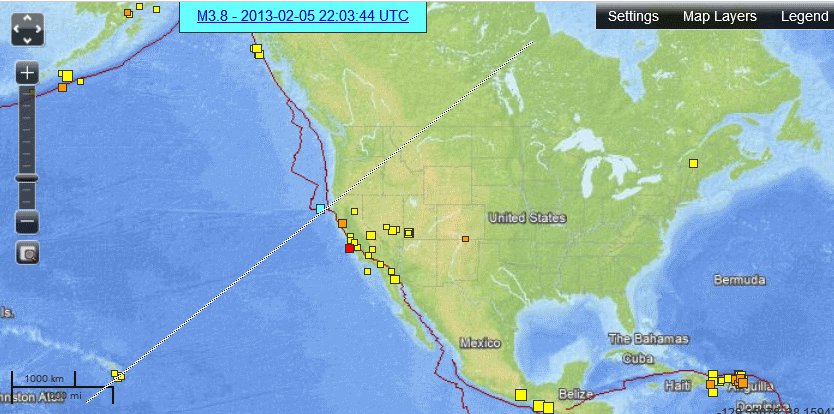
-edit to add: I cannot be absolutely certain that is a 'true' continuation of the line but given the fact I tried to pass from slightly south of the 'center' of the Hawaii quakes and continued slightly south of the quake I referenced, and there's nothing along that line, nor anywhere near it after it hit the NA plate... I'm probably fairly close to accurate.
If you continue that line even further:
-edit to add: I cannot be absolutely certain that is a 'true' continuation of the line but given the fact I tried to pass from slightly south of the 'center' of the Hawaii quakes and continued slightly south of the quake I referenced, and there's nothing along that line, nor anywhere near it after it hit the NA plate... I'm probably fairly close to accurate.
edit on 2/9/2013 by abecedarian because: (no reason given)
Yeah, she's cranked up again hot, pretty much coming in back to back now. This is the time that something big might happen...in the next minutes or
hours- it was in that state when the 8.0 slammed in... But at that point it was lots of little stuff going on. Now, we're getting back to back 4's and
5's...
EDIT; answer to question below: Absolutely not, I am not suggesting that at all. I am suggesting that a bigger event could happen while the fault is in an agitated state. That is all.
EDIT; answer to question below: Absolutely not, I am not suggesting that at all. I am suggesting that a bigger event could happen while the fault is in an agitated state. That is all.
edit on Sat Feb 9th 2013 by TrueAmerican because: (no reason given)
Originally posted by TrueAmerican
Yeah, she's cranked up again hot, pretty much coming in back to back now. This is the time that something big might happen...in the next minutes or hours- it was in that state when the 8.0 slammed in... But at that point it was lots of little stuff going on. Now, we're getting back to back 4's and 5's...
Are you suggesting this may have correlations to either time-of-day or tidal / lunar influences?
reply to post by abecedarian
I'd hazard the guess that if this is volcanic in origin, the magma would be more dense and thus more susceptible to gravitational influence than the surrounding substrates.
I suppose some solace can be taken in knowing that the surrounding 'known' volcanos are stratovolcanos and are not supervolcanos... but who can say, really, given the size of that hot spot linked to earlier....
reply to post by abecedarian
Okay, so I haven't subscribed much to this 'in a line theory' but in this situation, looking at that picture I have to admit it's a bit interesting. Normally, I would say that what TA is implying, is that the one further out than the rest may indicate another fault at work....what the even LONGER line out could indicate is that the junctions line up. Maybe. We have to take the curve of the earth into consideration, so in reality it wouldn't be a straight line like that....but it's still interesting.
Okay, so I haven't subscribed much to this 'in a line theory' but in this situation, looking at that picture I have to admit it's a bit interesting. Normally, I would say that what TA is implying, is that the one further out than the rest may indicate another fault at work....what the even LONGER line out could indicate is that the junctions line up. Maybe. We have to take the curve of the earth into consideration, so in reality it wouldn't be a straight line like that....but it's still interesting.
Originally posted by TrueAmerican
Yeah, she's cranked up again hot, pretty much coming in back to back now. This is the time that something big might happen...in the next minutes or hours- it was in that state when the 8.0 slammed in... But at that point it was lots of little stuff going on. Now, we're getting back to back 4's and 5's...
What site do you use to see the smaller ones?
new topics
-
SETI chief says US has no evidence for alien technology. 'And we never have'
Aliens and UFOs: 1 hours ago -
This is our Story
General Entertainment: 4 hours ago -
President BIDEN Vows to Make Americans Pay More Federal Taxes in 2025 - Political Suicide.
2024 Elections: 6 hours ago -
Ode to Artemis
General Chit Chat: 7 hours ago -
Ditching physical money
History: 10 hours ago -
One Flame Throwing Robot Dog for Christmas Please!
Weaponry: 10 hours ago -
Don't take advantage of people just because it seems easy it will backfire
Rant: 11 hours ago -
VirginOfGrand says hello
Introductions: 11 hours ago
top topics
-
University student disciplined after saying veganism is wrong and gender fluidity is stupid
Education and Media: 14 hours ago, 14 flags -
Police clash with St George’s Day protesters at central London rally
Social Issues and Civil Unrest: 17 hours ago, 10 flags -
President BIDEN Vows to Make Americans Pay More Federal Taxes in 2025 - Political Suicide.
2024 Elections: 6 hours ago, 10 flags -
Should Biden Replace Harris With AOC On the 2024 Democrat Ticket?
2024 Elections: 12 hours ago, 6 flags -
One Flame Throwing Robot Dog for Christmas Please!
Weaponry: 10 hours ago, 6 flags -
Ditching physical money
History: 10 hours ago, 4 flags -
Don't take advantage of people just because it seems easy it will backfire
Rant: 11 hours ago, 4 flags -
God lived as a Devil Dog.
Short Stories: 16 hours ago, 3 flags -
SETI chief says US has no evidence for alien technology. 'And we never have'
Aliens and UFOs: 1 hours ago, 3 flags -
VirginOfGrand says hello
Introductions: 11 hours ago, 2 flags
active topics
-
Remember These Attacks When President Trump 2.0 Retribution-Justice Commences.
2024 Elections • 51 • : Justoneman -
British TV Presenter Refuses To Use Guest's Preferred Pronouns
Education and Media • 131 • : FlyersFan -
Spectrophilia - Women Who Have Had Affairs With Ghosts Say Spooks Are Better Lovers Than Real Men
Paranormal Studies • 30 • : FlyersFan -
Breaking Baltimore, ship brings down bridge, mass casualties
Other Current Events • 471 • : bally001 -
-@TH3WH17ERABB17- -Q- ---TIME TO SHOW THE WORLD--- -Part- --44--
Dissecting Disinformation • 639 • : Justoneman -
University student disciplined after saying veganism is wrong and gender fluidity is stupid
Education and Media • 31 • : KrustyKrab -
SETI chief says US has no evidence for alien technology. 'And we never have'
Aliens and UFOs • 8 • : 19Bones79 -
Republican Voters Against Trump
2024 Elections • 289 • : Justoneman -
The Acronym Game .. Pt.3
General Chit Chat • 7742 • : bally001 -
"We're All Hamas" Heard at Columbia University Protests
Social Issues and Civil Unrest • 264 • : HopeForTheFuture