It looks like you're using an Ad Blocker.
Please white-list or disable AboveTopSecret.com in your ad-blocking tool.
Thank you.
Some features of ATS will be disabled while you continue to use an ad-blocker.

Confounding Sequence of Big Quakes Rattle Santa Cruz Islands
page: 6share:
reply to post by Aleister
I found that perculiar aswell....the amount of quakes at exactly 10km depth. Is the fault/plate only this thick? which is very thin in geophysical terms isnt it?
And if so, wouldnt that make the possibility of the crust in this area easily breaking off/moving up/displaced?
I found that perculiar aswell....the amount of quakes at exactly 10km depth. Is the fault/plate only this thick? which is very thin in geophysical terms isnt it?
And if so, wouldnt that make the possibility of the crust in this area easily breaking off/moving up/displaced?
reply to post by Melbourne_Militia
USGS uses 10 km as a default depth value (and sometimes 33 km) until they have time to work out the actual depth. Depth is difficult to pinpoint, unless the earthquake is directly under a seismometer. As the seismologists finish reviewing each quake, the depths should be revised with error estimates. Hope this helps.
USGS uses 10 km as a default depth value (and sometimes 33 km) until they have time to work out the actual depth. Depth is difficult to pinpoint, unless the earthquake is directly under a seismometer. As the seismologists finish reviewing each quake, the depths should be revised with error estimates. Hope this helps.
Originally posted by Olivine
reply to post by Melbourne_Militia
USGS uses 10 km as a default depth value (and sometimes 33 km) until they have time to work out the actual depth. Depth is difficult to pinpoint, unless the earthquake is directly under a seismometer. As the seismologists finish reviewing each quake, the depths should be revised with error estimates. Hope this helps.
Well that is something to take a picture of and send home to Uncle Ed. This ultra-sophisticated scientific organization, sharing its data with the world, puts up 10km as a placeholder? Who came up with that decision? They don't even explain it on the charts as far as I know. Thank you for clearing this up, as it was something I was wondering about more than once.
We need TrueAmerican back to analyze all the latest quakes of the last few hours, lots of 5's and high 4's and more all around the prime area in the
Soloman Islands and then a couple up towards New Guinea and Indonesia. Check out the map, it's still very interesting and from the latest activity it
doesn't seem to be letting up.
edit on 7-2-2013 by Aleister because: (no reason given)
edit on 7-2-2013 by Aleister because:
(no reason given)
They seem to be slowing down, getting smaller and contracting in area to the original 7.9. Looking like aftershocks now. But that is only the last 12
hours, could spike again. It sure was worrisome there for a while with the area expanding and the mags still so high. There should have been a tsunami
alert for the Pacific, at least to let people know to keep an ear on the radio/television for the possiblity of an evacuation order. Why didnt that
happen? Just because the first one only produced a tsunami of 1 meter does not mean that subsequent ones wouldnt do worse.
Things do seem to be normalizing now. I'd give it another 24 hours before assuming anything.
This may interest persons watching the Solomon Island region's Santa Cruz quake storms.
www.science20.com...
Perhaps it's coincidence that the article came out earlier today ... but, since the Santa Cruz quakes have been rattling for well over a week now ... maybe it's not coincidence.
This article is about LONG TERM effects/events so don't get all hari-kari, "doomsday" with it. The progression is in millions of years.
Thermochemical Piles And Cataclysmic Volcanic Eruptions In A Mega Ultra Low Velocity Zone
www.science20.com...
Perhaps it's coincidence that the article came out earlier today ... but, since the Santa Cruz quakes have been rattling for well over a week now ... maybe it's not coincidence.
This article is about LONG TERM effects/events so don't get all hari-kari, "doomsday" with it. The progression is in millions of years.
I thought you all might be interested in seeing this- the last 30 days of activity in that area:
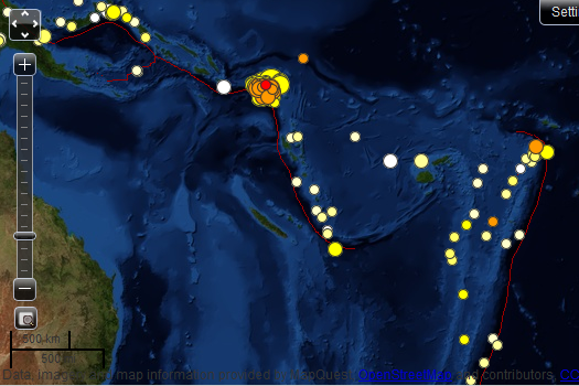
It doesn't necessarily mean anything...But still- curious for those that like to try and derive patterns of activity.
Now that's just 4.5+ activity. Everything BELOW 4.5 is not being displayed, so you are not really seeing a true picture of the activity.
I've been having some trouble with G.SANVU, the station in Vanuato, which is actually the closest active station to the activity, and curiously, not being used by the USGS much it seems in phase data for these quakes.
BUT, I just found a work around, and now am really seeing the extent of that fault movement. It remains highly active, with sub 4.5 quakes occurring just about constantly. So look at all those maps we've been posting in this thread, and imagine another 200 smaller events, at least, interspersed among what you actually see- and then you'll have a bit better idea of actual. And it's probably more like 500.
This is typical when a fault ruptures. You really aren't getting the whole picture.
As to the map above in this post, that quake down on the lower end of the fault I pointed out now has a bit more meaning- at least to me, when you can see the activity over the last 30 days. Where it's all going I don't know, but it appears that whole area, all the way out to the Samoa, is experienced some kind of increased pressure from the Pacific plate, causing these quakes.
Hopefully it will all just chill out soon...
reply to post by TrueAmerican
The Samoa/Tonga quake was put at 5.8 Mw by USGS WPhase(No. of sta: 42) and 5.9 Mw by GCMT Centroid tensors,
earthquake.usgs.gov/earthquakes/eqarchives/fm/neic_c000f31w_wmt.php
www.emsc-csem.org/Earthquake/mtfull.php?id=303826
The Samoa/Tonga quake was put at 5.8 Mw by USGS WPhase(No. of sta: 42) and 5.9 Mw by GCMT Centroid tensors,
earthquake.usgs.gov/earthquakes/eqarchives/fm/neic_c000f31w_wmt.php
www.emsc-csem.org/Earthquake/mtfull.php?id=303826
edit on 7-2-2013 by wujotvowujotvowujotvo because: (no reason given)
reply to post by Trexter Ziam
Interesting...
Soooo....basically....the earth is like a giant, round lava lamp!!!
Neat!
(You young ones might have to Google that!)
WOQ
Interesting...
Soooo....basically....the earth is like a giant, round lava lamp!!!
Neat!
(You young ones might have to Google that!)
WOQ
Body Wave (No. of sta:107) - 5.7 Mw, apparent 0.2 difference to GCMT
.
earthquake.usgs.gov/earthquakes/eqarchives/fm/neic_c000f31w_fmt.php
Feb 7 -
2 successive normal events(6 and 5.8), 2 successive strike-slips, 6.7(may go up from downgrade of 0.1 [NOAA PTWC] ; all tensors say 6.7) and 5.8.
Tonga/Samoa reverse of 5.7/5.8/5.9 USGS Body Wave/WPhase/GCMT
.
earthquake.usgs.gov/earthquakes/eqarchives/fm/neic_c000f31w_fmt.php
Feb 7 -
2 successive normal events(6 and 5.8), 2 successive strike-slips, 6.7(may go up from downgrade of 0.1 [NOAA PTWC] ; all tensors say 6.7) and 5.8.
Tonga/Samoa reverse of 5.7/5.8/5.9 USGS Body Wave/WPhase/GCMT
edit on 8-2-2013 by wujotvowujotvowujotvo because: (no reason given)
Another 7.1 from the Solomon Islands - 10 km depth. Just when I thought the little devil was about to settle down, too. Hope this is just another
aftershock, and not a harbinger of worse things to come, as per TA's confoundment.
Event Time
2013-02-08 11:12:12 UTC
2013-02-08 22:12:12 UTC+11:00 at epicenter
2013-02-08 21:12:12 UTC+10:00 system time
Location
10.925°S 165.875°E depth=10.0km (6.2mi)
Event Time
2013-02-08 11:12:12 UTC
2013-02-08 22:12:12 UTC+11:00 at epicenter
2013-02-08 21:12:12 UTC+10:00 system time
Location
10.925°S 165.875°E depth=10.0km (6.2mi)
edit on 8-2-2013 by FartyMeBurpy because: (no reason given)
Part of me believes that this 8, these 7s and the countless 6s are balancing out the area and in sum releasing enough energy that could have otherwise
been a larger 8, or even a 9 magnitude quake. I don't know the exact Math, but you get it.
Indeed, this latest 7.1M shows things aren't done and adds to the complexity, and unpredictable nature this activity has shown from the beginning. It's clear that the area is still unstable, and that it could possibly be getting ready for a quake as large as a 9 magnitude.
Indeed, this latest 7.1M shows things aren't done and adds to the complexity, and unpredictable nature this activity has shown from the beginning. It's clear that the area is still unstable, and that it could possibly be getting ready for a quake as large as a 9 magnitude.
Looks like the 7.1 has been downgraded to a 6.8...
MAP 6.8 2013/02/08 11:12:13 -10.904 165.895 18.0 SANTA CRUZ ISLANDS
MAP 6.8 2013/02/08 11:12:13 -10.904 165.895 18.0 SANTA CRUZ ISLANDS
Well this could go either way at this point. They could all be less than the 8.0 from here on out. But if another 7.6+ occurred, I think there would
be ample reason to believe at that point they would be foreshocks to a massive 9+. So let's just hope that doesn't happen, and that these remain
under that 1 mag threshold.
But man, that fault is not stopping. There are like continuous quakes occurring, one after the other. Too many to report. Watching the live seismic data come in is a bit like watching a fireworks display. We just don't know how big the grand finale's gonna be. Very reminiscent of what happened in Japan.
But man, that fault is not stopping. There are like continuous quakes occurring, one after the other. Too many to report. Watching the live seismic data come in is a bit like watching a fireworks display. We just don't know how big the grand finale's gonna be. Very reminiscent of what happened in Japan.
reply to post by TrueAmerican
Close call, 7.1
Close call, 7.1
edit on 8-2-2013 by rickymouse because: (no reason given)
Uh oh, got a big one incoming... stay tuned..
holy crap!, pulling 6e6
that's looking like 7+
USGS: 7.0
Note: latest solution has that depth at 27 km, which does not fit the depth profile at all of previous seismicity for that location... Fricken weird.
holy crap!, pulling 6e6
edit on Fri Feb 8th 2013 by TrueAmerican because: (no reason given)
that's looking like 7+
edit on Fri Feb 8th 2013 by TrueAmerican because: (no reason given)
USGS: 7.0
edit on Fri Feb 8th 2013 by TrueAmerican because: (no reason given)
Note: latest solution has that depth at 27 km, which does not fit the depth profile at all of previous seismicity for that location... Fricken weird.
edit on Fri Feb 8th 2013 by TrueAmerican because: (no reason given)
Looks like they converted one of the old ones (6.8, I believe) up to 7.1:
M7.1 - 114km WSW of Lata, Solomon Islands
2013-02-06 01:23:19 UTC
earthquake.usgs.gov...
M7.1 - 114km WSW of Lata, Solomon Islands
2013-02-06 01:23:19 UTC
earthquake.usgs.gov...

new topics
-
Thousands Of Young Ukrainian Men Trying To Flee The Country To Avoid Conscription And The War
Other Current Events: 2 hours ago -
12 jurors selected in Trump criminal trial
US Political Madness: 5 hours ago -
Iran launches Retalliation Strike 4.18.24
World War Three: 5 hours ago -
Israeli Missile Strikes in Iran, Explosions in Syria + Iraq
World War Three: 5 hours ago -
George Knapp AMA on DI
Area 51 and other Facilities: 11 hours ago -
Not Aliens but a Nazi Occult Inspired and then Science Rendered Design.
Aliens and UFOs: 11 hours ago
top topics
-
George Knapp AMA on DI
Area 51 and other Facilities: 11 hours ago, 25 flags -
Israeli Missile Strikes in Iran, Explosions in Syria + Iraq
World War Three: 5 hours ago, 14 flags -
Louisiana Lawmakers Seek to Limit Public Access to Government Records
Political Issues: 13 hours ago, 7 flags -
So I saw about 30 UFOs in formation last night.
Aliens and UFOs: 17 hours ago, 6 flags -
Iran launches Retalliation Strike 4.18.24
World War Three: 5 hours ago, 6 flags -
Not Aliens but a Nazi Occult Inspired and then Science Rendered Design.
Aliens and UFOs: 11 hours ago, 5 flags -
12 jurors selected in Trump criminal trial
US Political Madness: 5 hours ago, 4 flags -
The Tories may be wiped out after the Election - Serves them Right
Regional Politics: 15 hours ago, 3 flags -
Thousands Of Young Ukrainian Men Trying To Flee The Country To Avoid Conscription And The War
Other Current Events: 2 hours ago, 3 flags
active topics
-
Fossils in Greece Suggest Human Ancestors Evolved in Europe, Not Africa
Origins and Creationism • 60 • : whereislogic -
Scarface does Tiny Desk Concert
Music • 7 • : sitrose -
The Acronym Game .. Pt.3
General Chit Chat • 7727 • : F2d5thCavv2 -
Russia Ukraine Update Thread - part 3
World War Three • 5697 • : F2d5thCavv2 -
Do we live in a simulation similar to The Matrix 1999?
ATS Skunk Works • 22 • : SchrodingersRat -
Iran launches Retalliation Strike 4.18.24
World War Three • 15 • : semperfortis -
President BIDEN Warned IRAN Not to Attack ISRAEL - Iran Responded with a Military Attack on Israel.
World War Three • 43 • : WeMustCare -
Israeli Missile Strikes in Iran, Explosions in Syria + Iraq
World War Three • 52 • : WeMustCare -
Mandela Effect - It Happened to Me!
The Gray Area • 107 • : inflaymes69 -
Terrifying Encounters With The Black Eyed Kids
Paranormal Studies • 45 • : daskakik