It looks like you're using an Ad Blocker.
Please white-list or disable AboveTopSecret.com in your ad-blocking tool.
Thank you.
Some features of ATS will be disabled while you continue to use an ad-blocker.

North Atlantic Hurricane Watch 2013
page: 4share:
Hey Klaus, I mean Gaz, awesome pic man! Huge Damon fan myself while my daughter is in love with Matt. Anyway, I think I would have pooped myself if I
saw that in person.
Peace
Here is the link to your thread about it...
www.abovetopsecret.com...
Peace
Here is the link to your thread about it...
www.abovetopsecret.com...
Originally posted by Gazrok
We've been pretty calm here all day, just the usual summer storm pattern.
But look at THIS!
This was just off the same bridge as the vid I posted earlier. This was just TODAY, off a bridge I go across every day (twice).... Yikes!

edit on 19-6-2013 by lasertaglover because: (no reason given)
edit on 19-6-2013 by lasertaglover because: Added thread
link
So Tropical Storm Barry came and went pretty darn quick. Here is a summary of him:
"Tropical Depression Two developed on June 17, 2013 just off the coast of Honduras. The depression then moved inland later that day into Belize.
From there, Tropical Depression Two moved across Guatemala and southern Mexico and eventually into the Bay of Campeche late on June 18, 2013. On the afternoon of June 19, 2013, data from a Hurricane Hunter aircraft revealed that the depression had strengthened into Tropical Storm Barry.
Tropical Storm Barry then moved inland into the Mexican state of Veracruz on the morning of June 20, 2013 with heavy rain."
www.weather.com...
Peace
Yep, and all clear for now. We're sure getting a lot of afternoon showers though. I mean, it is the season for it, but still....
For the record:
Cosme formed as Tropical Depression Three-E well off the southwest coast of Mexico on June 23, 2013 and intensified to tropical-storm strength June 24, 2013 when its maximum sustained winds reached 40 miles per hour. It became the season's second hurricane (following Barbara) on June 25, 2013. It then weakened back to a tropical storm on June 26, 2013. The system finally degenerated into a remnant low over cooler waters on June 27, 2013.
www.weather.com...
Still looking clear through the Atlantic!
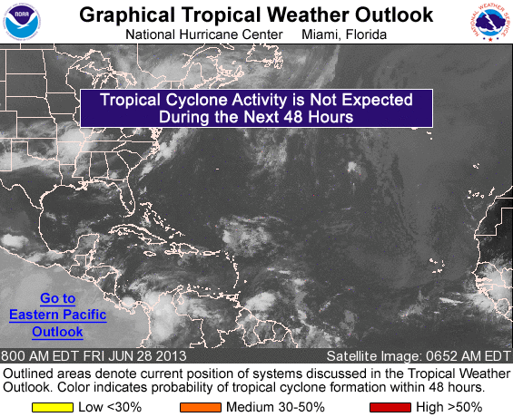
www.nhc.noaa.gov...
Peace
Cosme formed as Tropical Depression Three-E well off the southwest coast of Mexico on June 23, 2013 and intensified to tropical-storm strength June 24, 2013 when its maximum sustained winds reached 40 miles per hour. It became the season's second hurricane (following Barbara) on June 25, 2013. It then weakened back to a tropical storm on June 26, 2013. The system finally degenerated into a remnant low over cooler waters on June 27, 2013.
www.weather.com...
Still looking clear through the Atlantic!
www.nhc.noaa.gov...
Peace
edit on 28-6-2013 by lasertaglover because: (no reason given)
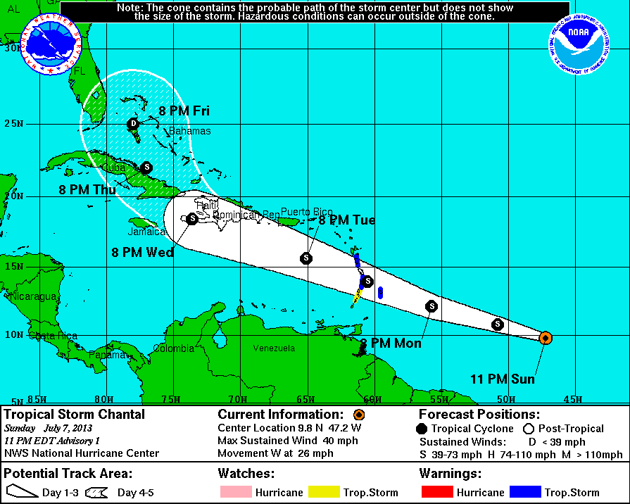
Tropical Storm CHANTAL forms in the Atlanic
BULLETIN
TROPICAL STORM CHANTAL ADVISORY NUMBER 1
NWS NATIONAL HURRICANE CENTER MIAMI FL AL032013
1100 PM EDT SUN JUL 07 2013 ...
TROPICAL STORM CHANTAL FORMS OVER THE CENTRAL TROPICAL ATLANTIC... ...RACING WEST-NORTHWESTWARD TOWARD THE LESSER ANTILLES...
AT 1100 PM EDT...0300 UTC...THE CENTER OF TROPICAL STORM CHANTAL WAS
LOCATED NEAR LATITUDE 9.8 NORTH...LONGITUDE 47.2 WEST. CHANTAL IS
MOVING TOWARD THE WEST NEAR 26 MPH...43 KM/H...AND THIS SAME RAPID
WESTWARD OR WEST-NORTHWESTWARD MOTION IS EXPECTED DURING THE NEXT
COUPLE OF DAYS. ON THE FORECAST TRACK...THE CENTER OF CHANTAL SHOULD
APPROACH THE LESSER ANTILLES LATE MONDAY NIGHT OR EARLY TUESDAY...
AND MOVE INTO THE EASTERN CARIBBEAN SEA ON TUESDAY.
MAXIMUM SUSTAINED WINDS ARE NEAR 40 MPH...65 KM/H...WITH HIGHER
GUSTS. SOME STRENGTHENING IS FORECAST DURING THE NEXT 48 HOURS.
edit on 7-7-2013 by iunlimited491 because: (no reason given)
reply to post by iunlimited491
So I leave for an awesome four day camping (drinking fest) and look what blows in while I am gone! Star for finding and posting!
I think the trajectory of coming close to the US is spot on, and I am worried for those in the Carribean as Chantal looks like a massive rainmaker for now.
Once close to Florida, it will all depend on the developing pressure systems across the US to see how much impact will happen.
Definitely going to be closely watching her. Thank you, and for any of you Hurricane trackers out there, please post any updates on here.
Me thinks Chantal is going to be making a lot of people nervous in the next few days.
www.nhc.noaa.gov...
Peace
edit on 8-7-2013 by lasertaglover because: linky
Living in the northeast as I do, I have found a greater appreciation for threads like this one.
Thank you.
beez
Thank you.
beez
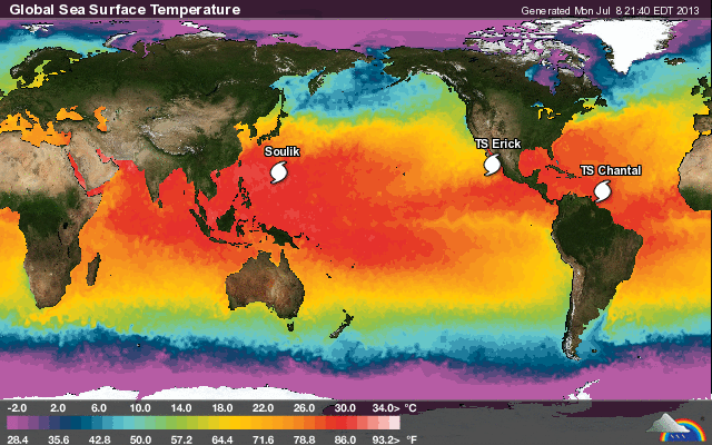
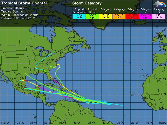
Just updating about Chantal with some graphs before I go tuck the kids in.
First, not liking some of these tracks at all:
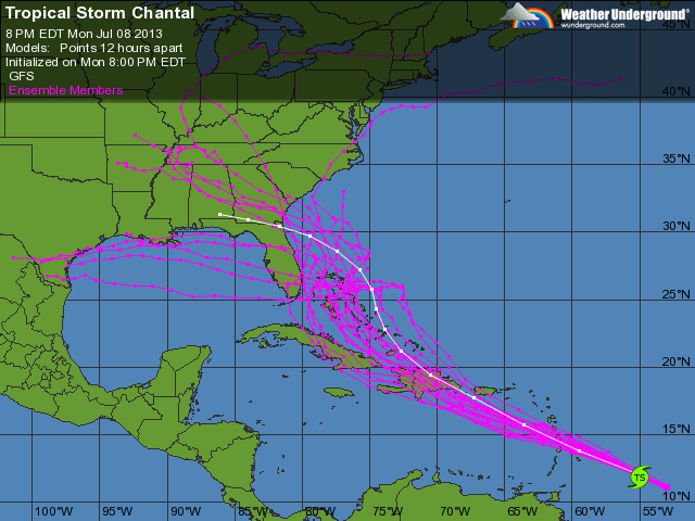
Second, I am not liking how warm the water is (but I like this view of all current storms, and fyi, Erick is heading away):
And last, here is a historic perspective of all July storms (that have formed within 2 degrees of Chantal) which paints a picture that clearly shows this storm needs to be tracked very closely:
Thanks to those getting interested. and hey...right now is the time to check your Hurricane Emergency plans, especially if you live anywhere along the East coast.
www.wunderground.com...
Peace
First, not liking some of these tracks at all:
Second, I am not liking how warm the water is (but I like this view of all current storms, and fyi, Erick is heading away):
And last, here is a historic perspective of all July storms (that have formed within 2 degrees of Chantal) which paints a picture that clearly shows this storm needs to be tracked very closely:
Thanks to those getting interested. and hey...right now is the time to check your Hurricane Emergency plans, especially if you live anywhere along the East coast.
www.wunderground.com...
Peace
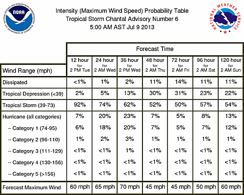
I am pleased to see that the models are not showing a huge increase in wind speed over the next week!
www.nhc.noaa.gov...
Peace
www.nhc.noaa.gov...
Peace
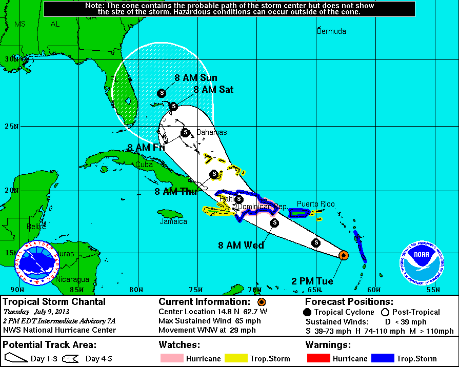
reply to post by lurksoften
Thank you for that update!
When I looked this morning, I was worried at first, because the forecast track has really shifted.
However, the wind forecast is minimal.
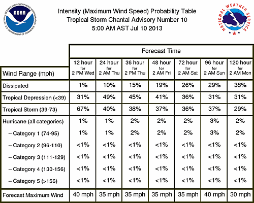
Looks like a she is just going to be a big rain maker to me. The atmospheric conditions, plus a bit of land and mountains on her way is going to keep her happily smaller!
www.nhc.noaa.gov...
Peace
Thank you for that update!
When I looked this morning, I was worried at first, because the forecast track has really shifted.
However, the wind forecast is minimal.
Looks like a she is just going to be a big rain maker to me. The atmospheric conditions, plus a bit of land and mountains on her way is going to keep her happily smaller!
www.nhc.noaa.gov...
Peace
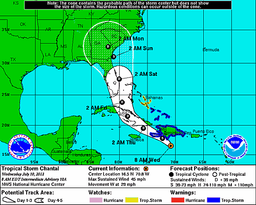
SUMMARY OF 200 PM EDT...1800 UTC...INFORMATION
----------------------------------------------
LOCATION...16.5N 73.0W
ABOUT 270 MI...430 KM ESE OF KINGSTON JAMAICA
MAXIMUM SUSTAINED WINDS...45 MPH...75 KM/H
PRESENT MOVEMENT...W OR 275 DEGREES AT 29 MPH...46 KM/H
MINIMUM CENTRAL PRESSURE...1011 MB...29.85 INCHES
WATCHES AND WARNINGS
--------------------
CHANGES WITH THIS ADVISORY...
THE GOVERNMENT OF THE DOMINICAN REPUBLIC HAS DISCONTINUED THE
TROPICAL STORM WARNING FOR THE DOMINICAN REPUBLIC.
SUMMARY OF WATCHES AND WARNINGS IN EFFECT...
A TROPICAL STORM WARNING IS IN EFFECT FOR...
* ENTIRE COAST OF HAITI
* TURKS AND CAICOS
* SOUTHEASTERN BAHAMAS
A TROPICAL STORM WATCH IS IN EFFECT FOR...
* CENTRAL BAHAMAS
* JAMAICA
ALL TROPICAL STORM WATCHES AND WARNINGS COULD BE DISCONTINUED LATER
TODAY IF CHANTAL DEGENERATES INTO A TROPICAL WAVE.
INTERESTS IN EASTERN CUBA AND THE NORTHWESTERN BAHAMAS SHOULD
MONITOR THE PROGRESS OF CHANTAL.
FOR STORM INFORMATION SPECIFIC TO YOUR AREA...PLEASE MONITOR
PRODUCTS ISSUED BY YOUR NATIONAL METEOROLOGICAL SERVICE.
DISCUSSION AND 48-HOUR OUTLOOK
------------------------------
AT 200 PM EDT...1800 UTC...THE CENTER OF TROPICAL STORM CHANTAL WAS
ESTIMATED NEAR LATITUDE 16.5 NORTH...LONGITUDE 73.0 WEST. CHANTAL IS
RACING WESTWARD NEAR 29 MPH...46 KM/H. IF CHANTAL REMAINS A TROPICAL
CYCLONE...A TURN TOWARD THE WEST-NORTHWEST AND NORTHWEST WITH A
GRADUAL DECREASE IN FORWARD SPEED IS EXPECTED DURING THE NEXT 48
HOURS. A MORE WESTWARD TRACK IS LIKELY IF CHANTAL DEGENERATES INTO
A WAVE.
MAXIMUM SUSTAINED WINDS ARE NEAR 45 MPH...75 KM/H...WITH HIGHER
GUSTS. THESE WINDS ARE CONFINED TO THE NORTH AND EAST OF THE
CENTER. DATA FROM A RECONNAISSANCE PLANE CURRENTLY INVESTIGATING
CHANTAL SUGGEST THAT THE CYCLONE IS DEGENERATING INTO A TROPICAL
WAVE.
TROPICAL STORM FORCE WINDS EXTEND OUTWARD UP TO 105 MILES...165 KM
TO THE NORTH AND EAST OF THE CENTER.
THE ESTIMATED MINIMUM CENTRAL PRESSURE IS 1011 MB...29.85 INCHES.
HAZARDS AFFECTING LAND
----------------------
WIND...TROPICAL STORM CONDITIONS WILL CONTINUE TO AFFECT HAITI
TODAY...EVEN IF CHANTAL LOSES ITS STATUS AS A TROPICAL CYCLONE. THE
LIKELIHOOD OF TROPICAL STORM CONDITIONS IN THE BAHAMAS AND THE
TURKS AND CAICOS ISLANDS IS DECREASING.
STORM SURGE...LOCALIZED COASTAL FLOODING IS POSSIBLE IN AREAS OF
ONSHORE FLOW ALONG PORTIONS OF THE SOUTH COAST OF HISPANIOLA.
RAINFALL...CHANTAL IS EXPECTED TO PRODUCE TOTAL RAIN ACCUMULATIONS
2 TO 4 INCHES OVER HISPANIOLA...CENTRAL AND EASTERN CUBA...AND THE
SOUTHEASTERN BAHAMAS. ISOLATED MAXIMUM AMOUNTS OF 6 INCHES ARE
POSSIBLE ACROSS SOUTHERN PORTIONS OF HISPANIOLA.
NEXT ADVISORY
-------------
NEXT COMPLETE ADVISORY...500 PM EDT.
Looks like this is going to get ripped apart after going over land.....
That's good. I've got 5 people in my household now (the stepkids came to live with us, which is cool, but now I've got to plan for 5, not 3 for supplies). So, need to do some more stocking.
That's good. I've got 5 people in my household now (the stepkids came to live with us, which is cool, but now I've got to plan for 5, not 3 for supplies). So, need to do some more stocking.
Chantal is toast... Chance of reforming only at 20%, which means just about nil...
reply to post by Gazrok
Real glad to see Chantal bit it Gaz! The rest of the Atlantic looks clear too, except for a couple of waves coming off of Africa. Wind sheer looks like its slicing and dicing those waves, so all good for awhile!
And the Gulf is looking nice and calm as well.
www.nhc.noaa.gov...
Peace
Real glad to see Chantal bit it Gaz! The rest of the Atlantic looks clear too, except for a couple of waves coming off of Africa. Wind sheer looks like its slicing and dicing those waves, so all good for awhile!
And the Gulf is looking nice and calm as well.
www.nhc.noaa.gov...
Peace
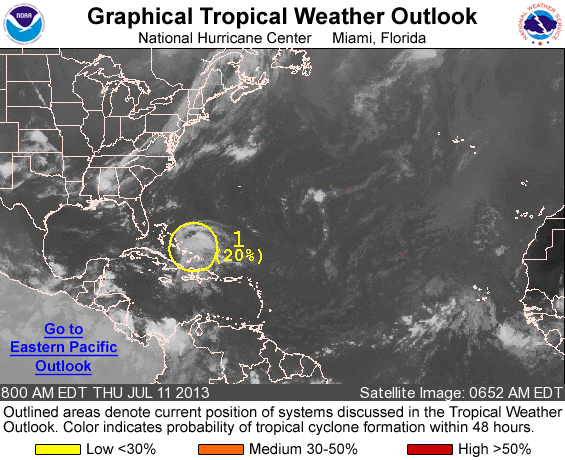
We have a system today with only a 10% chance of forming.
Here ya go:
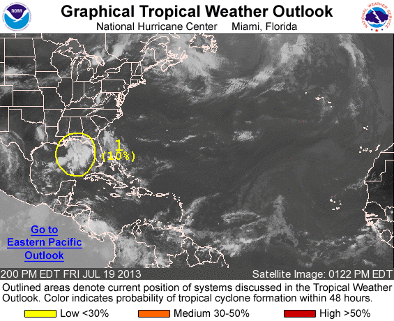
1. AN AREA OF CLOUDINESS AND THUNDERSTORMS OVER THE NORTHERN AND
NORTHEASTERN GULF OF MEXICO IS ASSOCIATED WITH AN UPPER-LEVEL LOW
PRESSURE AREA AND A SURFACE TROUGH. SLOW DEVELOPMENT OF THIS
SYSTEM IS POSSIBLE BEFORE IT MOVES INLAND OVER THE NORTHERN GULF
COAST ON SATURDAY. THIS SYSTEM HAS A LOW CHANCE...10 PERCENT...OF
BECOMING A TROPICAL CYCLONE DURING THE NEXT 48 HOURS.
www.nhc.noaa.gov...
Peace
Here ya go:
1. AN AREA OF CLOUDINESS AND THUNDERSTORMS OVER THE NORTHERN AND
NORTHEASTERN GULF OF MEXICO IS ASSOCIATED WITH AN UPPER-LEVEL LOW
PRESSURE AREA AND A SURFACE TROUGH. SLOW DEVELOPMENT OF THIS
SYSTEM IS POSSIBLE BEFORE IT MOVES INLAND OVER THE NORTHERN GULF
COAST ON SATURDAY. THIS SYSTEM HAS A LOW CHANCE...10 PERCENT...OF
BECOMING A TROPICAL CYCLONE DURING THE NEXT 48 HOURS.
www.nhc.noaa.gov...
Peace
edit on 19-7-2013 by lasertaglover because: (no reason given)
Neither the Atlantic or the Eastern Pacific have any systems with any chance of forming. All quiet.
www.nhc.noaa.gov...
Peace
www.nhc.noaa.gov...
Peace
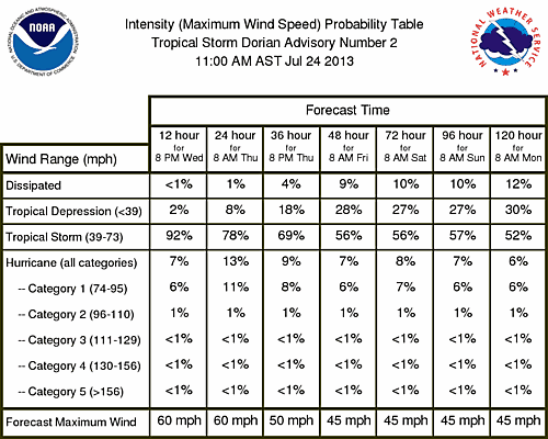
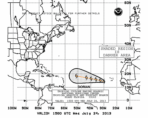
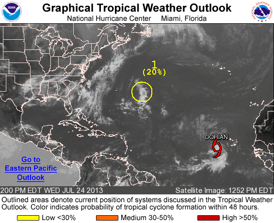
Tropical Storm DORIAN forms in the Atlantic
BULLETIN
TROPICAL STORM DORIAN ADVISORY
NWS NATIONAL HURRICANE CENTER MIAMI FL AL042013 1100 AM EDT WED JUL 24 2013
...FOURTH NAMED STORM OF THE 2013 SEASON FORMS...
SUMMARY OF 1100 AM EDT...1500 UTC...INFORMATION
-----------------------------------------------
LOCATION...14.3N 29.9W
ABOUT 410 MI...660 KM WSW OF THE CAPE VERDE ISLANDS
MAXIMUM SUSTAINED WINDS...50 MPH...85 KM/H
PRESENT MOVEMENT...WNW OR 285 DEGREES AT 21 MPH...33 KM/H MINIMUM CENTRAL PRESSURE...1002 MB...29.59 INCHES
WATCHES AND WARNINGS
--------------------
THERE ARE NO COASTAL WATCHES OR WARNINGS IN EFFECT.
DISCUSSION AND 48-HOUR OUTLOOK
------------------------------
SATELLITE IMAGERY AND DATA INDICATE THAT THE TROPICAL DEPRESSION IN THE EASTERN TROPICAL ATLANTIC HAS STRENGTHENED THIS MORNING.
AT 1100 AM EDT...1500 UTC...THE CENTER OF TROPICAL STORM DORIAN WAS LOCATED NEAR LATITUDE 14.3 NORTH...LONGITUDE 29.9 WEST. DORIAN IS MOVING TOWARD THE WEST-NORTHWEST NEAR 21 MPH...33 KM/H...AND THIS GENERAL MOTION IS EXPECTED TO CONTINUE DURING THE NEXT COUPLE OF DAYS.
MAXIMUM SUSTAINED WINDS ARE NEAR 50 MPH...85 KM/H...WITH HIGHER GUSTS. SOME SLIGHT STRENGTHENING IS POSSIBLE TODAY...FOLLOWED BY GRADUAL WEAKENING ON THURSDAY AS DORIAN MOVES OVER COOLER WATER.
TROPICAL-STORM-FORCE WINDS EXTEND OUTWARD UP TO 45 MILES...75 KM FROM THE CENTER. THE ESTIMATED MINIMUM CENTRAL PRESSURE IS 1002 MB...29.59 INCHES.
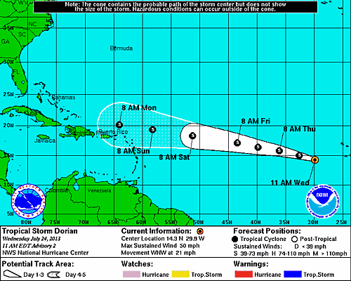
www.nhc.noaa.gov...
edit on 24-7-2013 by iunlimited491 because: (no reason given)
reply to post by iunlimited491
Great catch. Star. This one developed quickly. Looks like it is going to go through some unfavorable conditions so it is expected to weaken over the next several days.
Will defeinitely have to watch Dorian and the Atlantic more closely at this time of the year!
www.nhc.noaa.gov...
Peace
Great catch. Star. This one developed quickly. Looks like it is going to go through some unfavorable conditions so it is expected to weaken over the next several days.
Will defeinitely have to watch Dorian and the Atlantic more closely at this time of the year!
www.nhc.noaa.gov...
Peace

new topics
-
The good, the Bad and the Ugly!
Diseases and Pandemics: 1 hours ago -
Russian intelligence officer: explosions at defense factories in the USA and Wales may be sabotage
Weaponry: 3 hours ago -
African "Newcomers" Tell NYC They Don't Like the Free Food or Shelter They've Been Given
Social Issues and Civil Unrest: 4 hours ago -
Russia Flooding
Other Current Events: 6 hours ago -
MULTIPLE SKYMASTER MESSAGES GOING OUT
World War Three: 6 hours ago -
Two Serious Crimes Committed by President JOE BIDEN that are Easy to Impeach Him For.
US Political Madness: 7 hours ago -
911 emergency lines are DOWN across multiple states
Breaking Alternative News: 7 hours ago -
Former NYT Reporter Attacks Scientists For Misleading Him Over COVID Lab-Leak Theory
Education and Media: 9 hours ago -
Why did Phizer team with nanobot maker
Medical Issues & Conspiracies: 10 hours ago -
Pro Hamas protesters at Columbia claim hit with chemical spray
World War Three: 10 hours ago
top topics
-
Go Woke, Go Broke--Forbes Confirms Disney Has Lost Money On Star Wars
Movies: 14 hours ago, 13 flags -
Pro Hamas protesters at Columbia claim hit with chemical spray
World War Three: 10 hours ago, 11 flags -
Elites disapearing
Political Conspiracies: 12 hours ago, 9 flags -
Freddie Mercury
Paranormal Studies: 14 hours ago, 7 flags -
African "Newcomers" Tell NYC They Don't Like the Free Food or Shelter They've Been Given
Social Issues and Civil Unrest: 4 hours ago, 7 flags -
A Personal Cigar UFO/UAP Video footage I have held onto and will release it here and now.
Aliens and UFOs: 12 hours ago, 5 flags -
Two Serious Crimes Committed by President JOE BIDEN that are Easy to Impeach Him For.
US Political Madness: 7 hours ago, 5 flags -
Russian intelligence officer: explosions at defense factories in the USA and Wales may be sabotage
Weaponry: 3 hours ago, 4 flags -
911 emergency lines are DOWN across multiple states
Breaking Alternative News: 7 hours ago, 4 flags -
Former NYT Reporter Attacks Scientists For Misleading Him Over COVID Lab-Leak Theory
Education and Media: 9 hours ago, 4 flags
active topics
-
Russian intelligence officer: explosions at defense factories in the USA and Wales may be sabotage
Weaponry • 67 • : Lazy88 -
Former NYT Reporter Attacks Scientists For Misleading Him Over COVID Lab-Leak Theory
Education and Media • 4 • : Vermilion -
Russia Flooding
Other Current Events • 4 • : Dalamax -
African "Newcomers" Tell NYC They Don't Like the Free Food or Shelter They've Been Given
Social Issues and Civil Unrest • 8 • : FlyersFan -
Elites disapearing
Political Conspiracies • 22 • : CitizenB -
I Guess Cloud Seeding Works
Fragile Earth • 22 • : Degradation33 -
-@TH3WH17ERABB17- -Q- ---TIME TO SHOW THE WORLD--- -Part- --44--
Dissecting Disinformation • 520 • : cherokeetroy -
Two Serious Crimes Committed by President JOE BIDEN that are Easy to Impeach Him For.
US Political Madness • 9 • : Myhandle -
MULTIPLE SKYMASTER MESSAGES GOING OUT
World War Three • 15 • : cherokeetroy -
A Personal Cigar UFO/UAP Video footage I have held onto and will release it here and now.
Aliens and UFOs • 10 • : Hakaiju