It looks like you're using an Ad Blocker.
Please white-list or disable AboveTopSecret.com in your ad-blocking tool.
Thank you.
Some features of ATS will be disabled while you continue to use an ad-blocker.

The Anasazi Sun Dagger Calender
page: 17
share:
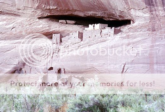
The Anasazi, the enigmatic people of the U.S. southwest, are best known for their precipitous cliff dwellings pearched high above the desert floor.
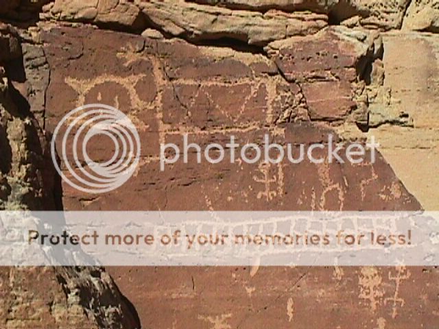
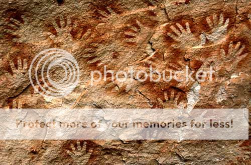
They also carved and painted the rocks of the desert
And at Chaco Canyon they built huge kivas on the canyon floor.
With all of that impressive architecture, and rock art, this butte
was the site of one of their most amazing accomplishments, and it is this like of rocks.
They also carved and painted the rocks of the desert
And at Chaco Canyon they built huge kivas on the canyon floor.
With all of that impressive architecture, and rock art, this butte
was the site of one of their most amazing accomplishments, and it is this like of rocks.
This pile of seemingly natural rocks is the Fajada Buttes Sun Dagger Calendar.
More on the butte itself
Again anasazi rock art comedy into play.
Not only does this calendar track the sun but it does so for the moon as well.
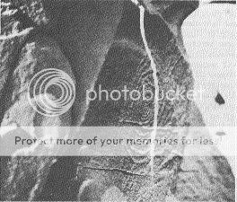
The sun dagger as it pierces the spiral.
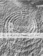
The small spot of sunlight can just be seen at the top.
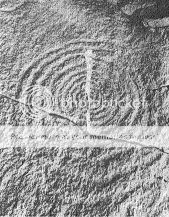
The light dagger moves downwards.
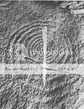
One aspect of the genius of this system is that it i symetrical on either side of the equinoxes/solstices,
and it works in moonlight as well
My battery is dying,
I hope I've given everyone something to ponder
All of the sourced material was from this site.
www.solsticeproject.org...
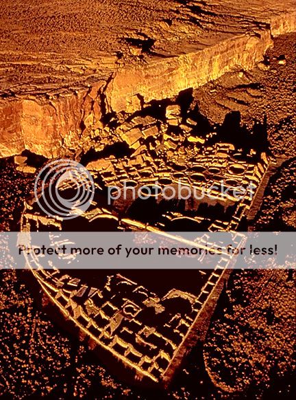
Near the top of an isolated butte in Chaco Canyon, New Mexico, three large stone slabs collimate sunlight in vertical patterns of light on two spiral petroglyphs carved on the cliff behind them. The light illuminates the spirals each day near noon in a changing pattern throughout the year and marks the solstices and equinoxes with particular images. At summer solstice a narrow vertical form of light moves downward near noon through the center of the larger spiral. At equinox and winter solstice corresponding forms of light mark the spirals. We found that the relationship between the shape and orientation of the slabs and the resultant light patterns on the cliff is a complex one and required a sophisticated appreciation of astronomy and geometry for its realization. The site is unique in employing the varying height of the midday sun during the year to provide readings of solar declination. In this respect it is clearly different in concept from the many archeoastronomical sites throughout the ancient New and Old Worlds that tell the passage of the year by marking the rising and setting points of the sun and moon (1).
More on the butte itself
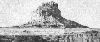
Fajada Butte stands prominently in the south entrance of Chaco Canyon (Fig. 2), rising 135 meters above the valley floor to an elevation of 2018 meters. The butte is difficult to climb, and there is neither water nor soil on it. Yet from bottom to top are many examples of Indian rock art carved and painted on the cliffs (7), the ruins of a number of small Pueblo buildings, and countless pottery shards. This concentration of remains attests to its active use by the Indians. The butte is a natural site for astronomical observations, with its clear views to distant horizons (4).
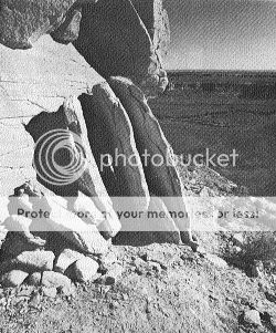
The last 10 m to the summit of the butte on the southeast face is formed by a vertical cliff with a narrow ledge at its foot. The assembly we will describe consists of an unusual arrangement of three stone slabs 2 to 3 m in height, standing on edge on this ledge and leaning against the cliff. The slabs are slightly off the vertical (Fig. 3) and fan out radially (Fig. 4). They are close together, separated by only 10 centimeters at their inner edges, but do not touch. The slabs keep the cliff face behind them in shadow except near midday, when the sun shines between them to cast patterns of light (8).
Again anasazi rock art comedy into play.
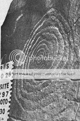
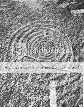
Two spiral petroglyphs are carved (''pecked'') on the cliff immediately behind the slabs (Fig. 5). The larger and more prominent spiral is located behind the opening of slabs one and two. It has 9 1/2 turns and is elliptical in shape (34 by 41 cm). The smaller spiral (9 by 13 cm) is above and to the left behind the opening between slabs two and three. It has 2 1/2 turns and a loop extends out of its upper right side. The spirals can be seen in their entirety only from the right of slab one. From this position, the larger spiral appears circular, suggesting that this was the intended viewpoint (Fig. 6). The length of time the sun shines between the slabs onto the spirals varies from 18 minutes near noon at summer solstice (when the sun is highest in the sky) to 3 hours or more at winter solstice (when the sun is lowest)
Not surprisingly, moonlight generally creates the same patterns on the spirals as the sun, on nights when the moon is between first and third quarter. The periodic changes in these patterns reflect the complexity of the moon's apparent motion (9), and certain combinations of patterns are associated with specific lunar eclipses.
Not only does this calendar track the sun but it does so for the moon as well.
The sun dagger as it pierces the spiral.
The small spot of sunlight can just be seen at the top.
The light dagger moves downwards.
One aspect of the genius of this system is that it i symetrical on either side of the equinoxes/solstices,
and it works in moonlight as well
My battery is dying,
I hope I've given everyone something to ponder
All of the sourced material was from this site.
www.solsticeproject.org...
reply to post by punkinworks10
Great thread, thank you for posting.
I remember watching a documentary on PBS a few years ago about Chaco Canyon. What an amazing place!
Anyhoo, I remember the lady researcher that found the sun dagger spiral. I can not remember her name but she found the spiral completely by accident. That discovery launched the investigation of galactic alignments there. I am fascinated with Chaco Canyon and the myths and legends behind it. Thanks again, I am going to go research this subject some more now. S&F4U!
I love sun daggers!
Part of my rock art research involved going to Painted Rocks near ("sorta near") San Angelo, Texas. One of the sun daggers shows the Cherokee turtle (the light hits the middle of the turtle at midsummer.) Another one appears to commemorate the death of someone... a figure is shown walking upwards, and food and clothes for his journey are painted on the line of ascension.
Part of my rock art research involved going to Painted Rocks near ("sorta near") San Angelo, Texas. One of the sun daggers shows the Cherokee turtle (the light hits the middle of the turtle at midsummer.) Another one appears to commemorate the death of someone... a figure is shown walking upwards, and food and clothes for his journey are painted on the line of ascension.
Originally posted by Byrd
I love sun daggers!
Part of my rock art research involved going to Painted Rocks near ("sorta near") San Angelo, Texas. One of the sun daggers shows the Cherokee turtle (the light hits the middle of the turtle at midsummer.) Another one appears to commemorate the death of someone... a figure is shown walking upwards, and food and clothes for his journey are painted on the line of ascension.
I was stunned by the amount of observation it would have taken to devise such a device, that not only indicates the solstices and equinoxes, with not only sun light but with moon light as well. Devising the arrangement of the slabs and positioning them such is simply amazing.
I once spent a weekend in san angelo, visiting friends of the ex wife, had I'd known there was cools turf like rock art nearby, I wouldn't have spent two of the most boring days of my life.
Hey Byrd, speaking of rock art, would you know of any material on rock art in the san Joaquin valley of California, particularly on the san Joaquin river?
Here's a simple illustration that shows how they're made;

The Anasazi had some incredible masonry skills, shame they didn't have a better developed writing system that could offer more insight into their culture.
The Anasazi had some incredible masonry skills, shame they didn't have a better developed writing system that could offer more insight into their culture.
Originally posted by Blackmarketeer
Here's a simple illustration that shows how they're made;
The Anasazi had some incredible masonry skills, shame they didn't have a better developed writing system that could offer more insight into their culture.
Hi Blackmarketeer,
Thanks for that.
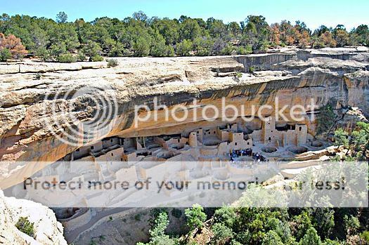
They certainly did know how to build, I've been to Mesa Verde, and few smaller sites in sw Utah.
Some of the places were essentially inaccessible. It stunned me how difficult they made thier lives and for what reasons?
Originally posted by punkinworks10
Hey Byrd, speaking of rock art, would you know of any material on rock art in the san Joaquin valley of California, particularly on the san Joaquin river
If memory serves, there is some -- but the only ones I went out to find were the Chumash sites near San Jose and Painted Rock and Inscription Canyon. I have ambitions to return to Inscription Canyon and document it and offer the photos to the Native American History museum.
My trips to California have been limited by which convention I'm going to and how long I can afford to stay. The husband and I are talking about taking a longer trip next year that would include California and other states.
Originally posted by Byrd
Originally posted by punkinworks10
Hey Byrd, speaking of rock art, would you know of any material on rock art in the san Joaquin valley of California, particularly on the san Joaquin river
If memory serves, there is some -- but the only ones I went out to find were the Chumash sites near San Jose and Painted Rock and Inscription Canyon. I have ambitions to return to Inscription Canyon and document it and offer the photos to the Native American History museum.
My trips to California have been limited by which convention I'm going to and how long I can afford to stay. The husband and I are talking about taking a longer trip next year that would include California and other states.
Thanks Byrd,
I stumbled across the San Joaquin river sites by accident while fishing as a teen and another site about 25 years ago. The river cuts a 200' deep bottom as it flows through Fresno, and there are " caves" that are formed by undercut erosion of the overlying siltstone. The caves are usually no more than a few feet high and several feet deep. In two of these, a few miles apart, there were glyphs carved into the roofs, they mostly consisted of spirals, starbursts, zigzags and and a couple of stick figures.
It's a shame they were never documented, because I'm afraid the caves have likely collapsed. I was unable to relocate them a few years ago.
Which site is near san jose? Wouldn't that be Esselen, Ohlone, or Salinian?
On a chumashan related subject, what do you think of a Clovis/ chumash connection.
I have found two archeological sites, one here in fresno county, and long forgotten it was last excavated in the early sixties, and a new site from malibu, farpoint, that lies below a chumash habitation layer.
www.farpointsite.blogspot.com...
The site in fresno county, The Witt site, it contained one of the best assemblages of Clovis points found, it walk contained a large amount of lithics associated with the western stemmed tradition and cresents found with pre chumash paleo Indian sites.
I coverd it in this thread www.abovetopsecret.com... if you are interested.
Originally posted by punkinworks10
Originally posted by Byrd
Originally posted by punkinworks10
Hey Byrd, speaking of rock art, would you know of any material on rock art in the san Joaquin valley of California, particularly on the san Joaquin river
If memory serves, there is some -- but the only ones I went out to find were the Chumash sites near San Jose and Painted Rock and Inscription Canyon. I have ambitions to return to Inscription Canyon and document it and offer the photos to the Native American History museum.
My trips to California have been limited by which convention I'm going to and how long I can afford to stay. The husband and I are talking about taking a longer trip next year that would include California and other states.
Thanks Byrd,
I stumbled across the San Joaquin river sites by accident while fishing as a teen and another site about 25 years ago. The river cuts a 200' deep bottom as it flows through Fresno, and there are " caves" that are formed by undercut erosion of the overlying siltstone. The caves are usually no more than a few feet high and several feet deep. In two of these, a few miles apart, there were glyphs carved into the roofs, they mostly consisted of spirals, starbursts, zigzags and and a couple of stick figures.
It's a shame they were never documented, because I'm afraid the caves have likely collapsed. I was unable to relocate them a few years ago.
Which site is near san jose? Wouldn't that be Esselen, Ohlone, or Salinian?
On a chumashan related subject, what do you think of a Clovis/ chumash connection.
I have found two archeological sites, one here in fresno county, and long forgotten it was last excavated in the early sixties, and a new site from malibu, farpoint, that lies below a chumash habitation layer.
www.farpointsite.blogspot.com...
The site in fresno county, The Witt site, it contained one of the best assemblages of Clovis points found, it walk contained a large amount of lithics associated with the western stemmed tradition and cresents found with pre chumash paleo Indian sites.
I coverd it in this thread www.abovetopsecret.com... if you are interested.
Will have to check out your thread (running off to scheduled volunteer time right now) -- the ones I looked at were around Painted Cave, and were of necessity just the more popular sites (I go to California for 3-4 day visits and most of the time I'm at a convention. So it has to be someplace findable and quick.)
I haven't actually given Chumash/Clovis much thought because, as I understand it, there's about 3,000 years distance in the two. The research I read indicated that the Chumash (although one of the oldest groups) arrived about the time that the Ice Age truly ended and most of the large mammals had died off. I associate Clovis (perhaps wrongly) with the megafauna and dates up to about 12,000 years.
But... I'm interested in discussing this and learning what I can from it.
new topics
-
Thousands Of Young Ukrainian Men Trying To Flee The Country To Avoid Conscription And The War
Other Current Events: 3 hours ago -
12 jurors selected in Trump criminal trial
US Political Madness: 5 hours ago -
Iran launches Retalliation Strike 4.18.24
World War Three: 6 hours ago -
Israeli Missile Strikes in Iran, Explosions in Syria + Iraq
World War Three: 6 hours ago
top topics
-
George Knapp AMA on DI
Area 51 and other Facilities: 12 hours ago, 25 flags -
Israeli Missile Strikes in Iran, Explosions in Syria + Iraq
World War Three: 6 hours ago, 15 flags -
Louisiana Lawmakers Seek to Limit Public Access to Government Records
Political Issues: 14 hours ago, 7 flags -
So I saw about 30 UFOs in formation last night.
Aliens and UFOs: 17 hours ago, 6 flags -
Iran launches Retalliation Strike 4.18.24
World War Three: 6 hours ago, 6 flags -
Not Aliens but a Nazi Occult Inspired and then Science Rendered Design.
Aliens and UFOs: 12 hours ago, 5 flags -
12 jurors selected in Trump criminal trial
US Political Madness: 5 hours ago, 4 flags -
The Tories may be wiped out after the Election - Serves them Right
Regional Politics: 15 hours ago, 3 flags -
Thousands Of Young Ukrainian Men Trying To Flee The Country To Avoid Conscription And The War
Other Current Events: 3 hours ago, 3 flags
active topics
-
-@TH3WH17ERABB17- -Q- ---TIME TO SHOW THE WORLD--- -Part- --44--
Dissecting Disinformation • 537 • : brewtiger123 -
Graham Hancock being proven right all along about ancient humans in America.
Ancient & Lost Civilizations • 105 • : bluesfreak2 -
Thousands Of Young Ukrainian Men Trying To Flee The Country To Avoid Conscription And The War
Other Current Events • 2 • : DerBeobachter2 -
The Tories may be wiped out after the Election - Serves them Right
Regional Politics • 23 • : andy06shake -
Mandela Effect - It Happened to Me!
The Gray Area • 109 • : ArMaP -
Mood Music Part VI
Music • 3058 • : Hellmutt -
Fossils in Greece Suggest Human Ancestors Evolved in Europe, Not Africa
Origins and Creationism • 60 • : whereislogic -
Scarface does Tiny Desk Concert
Music • 7 • : sitrose -
The Acronym Game .. Pt.3
General Chit Chat • 7727 • : F2d5thCavv2 -
Russia Ukraine Update Thread - part 3
World War Three • 5697 • : F2d5thCavv2
7