It looks like you're using an Ad Blocker.
Please white-list or disable AboveTopSecret.com in your ad-blocking tool.
Thank you.
Some features of ATS will be disabled while you continue to use an ad-blocker.

Remnants of a Lost World: Ancient Atlantic Mariners - Navigation
page: 1share:
I've been tooling around with a few thoughts for many years ever since I first came to ATS and read many fascinating threads on possible Ancient
mariners and mappers. Now if what is required to sail the worlds deep oceans were Time pieces, Sextants and deep water capable vessels then we may
have to use our collective ATS skills to pull it all together here.
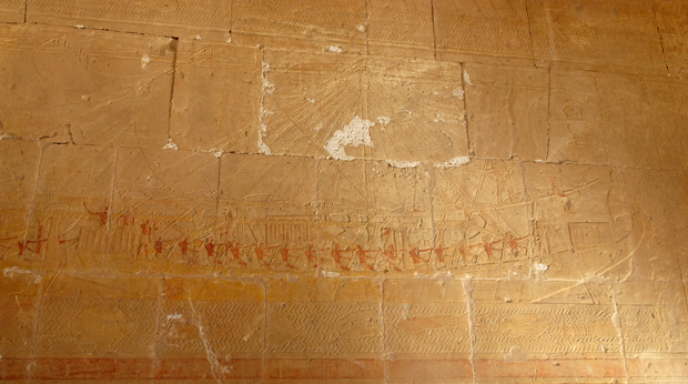
From one of my other threads. A relief at the temple of the female pharaoh Hatshepsut in Luxor, Egypt, carved ca. 1480 B.C., shows a merchant ship on a trading expedition. Vessel artifacts match this depiction.
Egypt's Ancient Fleet: Lost for Thousands of Years, Discovered in a Desolate Cave
On page 3 of that thread Scott Creighton posted this reply
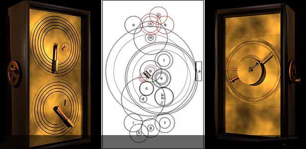
Clocks are very important for Navigation. I think the Antikythera Mechanism is evidence of the technical know how long before John Harrison's invention imho If the Antikythera Mechanism dates back further than the first century B.C. it could be based on even older technology long before they are given credit.
Navigation
We must not leave out the fact that the Greeks themselves looked to a people with respect and admiration who were Ancient even in their period of Greek achievements and those people were the Ancient Egyptians.
So the Ancient Greeks knew and Admired the Ancient Egyptians who had a possible Sextant 1500 years before the Mechanism was supposedly made and the Antikythera Mechanism obviously displays the ability to keep time which is crucial for navigation and they had deep water vessels.
So..
Is it possible that these fairly well dispersed pieces of the puzzle were at one time used together to navigate the globe or at least the Greater Atlantic in prehistory? This is just information we know of based on Greek, Roman and Egyptian technology. What about arguably the greatest mariners in Mediterranean history?
 The Phoenicians
The verdict is still out on just how far out they traveled the globe. Nobody who are familiar with their history would argue against the fact that they knew what they were doing...
[atsimg]http://files.abovetopsecret.com/images/member/e80087319417.jpg[/atsimg]
HOLY CRAP: They Found Atlantis!
Ancient Atlantic port city which was not known. This intrigued me. How many other locations have yet to discovered and where were these ancient Atlantic traders going and trading with whom and how far back in prehistory did this trading go?
Does this fragment of the Piri Reis map really show Central,South American and Antarctic shores?
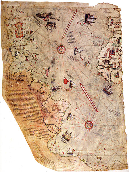
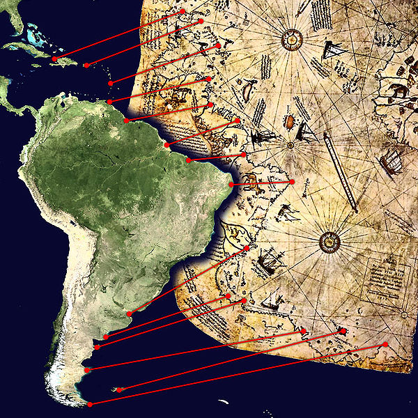
Piri Reis Map
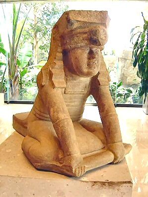
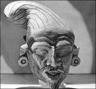
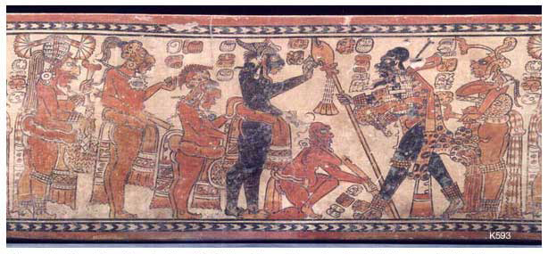
What about early Olmec/Mayan artwork?
Should we reexamine the old Cocaine and Tobacco in ancient Egypt arguments? That is the topic of another thread imho.
What we do find are scattered pieces of the puzzle. Have we tried looking outside the box in an attempt to draw another possible conclusion of what we think we know about prehistoric seafarers? Well, I hope you enjoyed this speculative presentation. As always I end up with more questions than answers. Next We'll explore ancient Pacific seafarers and their possible connection to the New world in Antiquity.
As Always stay frosty...
From one of my other threads. A relief at the temple of the female pharaoh Hatshepsut in Luxor, Egypt, carved ca. 1480 B.C., shows a merchant ship on a trading expedition. Vessel artifacts match this depiction.
Egypt's Ancient Fleet: Lost for Thousands of Years, Discovered in a Desolate Cave
An ancient harbor on the Red Sea proves ancient Egyptians mastered oceangoing technology and launched a series of ambitious expeditions to far-off lands.
The scenes carved into a wall of the ancient Egyptian temple at Deir el-Bahri tell of a remarkable sea voyage. A fleet of cargo ships bearing exotic plants, animals, and precious incense navigates through high-crested waves on a journey from a mysterious land known as Punt or “the Land of God.” The carvings were commissioned by Hatshepsut, ancient Egypt’s greatest female pharaoh, who controlled Egypt for more than two decades in the 15th century B.C. She ruled some 2 million people and oversaw one of most powerful empires of the ancient world.
The exact meaning of the detailed carvings has divided Egyptologists ever since they were discovered in the mid-19th century. “Some people have argued that Punt was inland and not on the sea, or a fictitious place altogether,” Oxford Egyptologist John Baines says. Recently, however, a series of remarkable discoveries on a desolate stretch of the Red Sea coast has settled the debate, proving once and for all that the masterful building skills of the ancient Egyptians applied to oceangoing ships as well as to pyramids.
Sextant?
Back in 1-8-2011 anon72 posted this thread here
[atsimg]http://files.abovetopsecret.com/images/member/89ff1f7b315e.jpg[/atsimg]
Source: archaeologynewsnetwork.blogspot.com...
The architect Kha helped to build pharaohs' tombs during the 18th dynasty, around 1400 BC. His own tomb was discovered intact in 1906 by archaeologist Ernesto Schiaparelli in Deir-al-Medina, near the Valley of the Kings. Among Kha's belongings were measuring instruments including cubit rods, a levelling device that resembles a modern set square, and what appeared to be an oddly shaped empty wooden case with a hinged lid.
On page 3 of that thread Scott Creighton posted this reply
Hello Anon72.
I rather suspect this ancient instrument is more likely to have been a 'primitive' 'mariner's quadrant - an early sextant' used to measure star elevations and for navigation.

Mariner's Quadrant below):

Regards,
Scott Creighton
Clock?
Clocks are very important for Navigation. I think the Antikythera Mechanism is evidence of the technical know how long before John Harrison's invention imho If the Antikythera Mechanism dates back further than the first century B.C. it could be based on even older technology long before they are given credit.
Navigation
Navigation Navigation by ships and planes depends on the ability to measure latitude and longitude. Latitude is fairly easy to determine through celestial navigation, but the measurement of longitude requires accurate measurement of time. This need was a major motivation for the development of accurate mechanical clocks. John Harrison created the first highly accurate marine chronometer in the mid-18th century.
Deep sea Vessels?
Blackmarketeer posted this article
Wood's Hole Oceanographic and Greek authorities also recently announced several recent shipwrecks that were discovered in deep water, which as WHOI says, indicates ancient Romans and Greeks did in fact sail in deep water/open seas, versus hugging coast lines. They had to have good navigation, charts, and an ability to navigate by stars for extended periods of time, as opposed to 'dead reckoning' and sailing by landmarks.
Roman shipwrecks found nearly a mile deep
Greek experts find Roman wrecks nearly a mile deep
U.S. archaeologist Brendan Foley, who was not involved in the project, said a series of ancient wrecks located far from land over the past 15 years has forced experts to reconsider the coast-hugging theory.
We must not leave out the fact that the Greeks themselves looked to a people with respect and admiration who were Ancient even in their period of Greek achievements and those people were the Ancient Egyptians.
So the Ancient Greeks knew and Admired the Ancient Egyptians who had a possible Sextant 1500 years before the Mechanism was supposedly made and the Antikythera Mechanism obviously displays the ability to keep time which is crucial for navigation and they had deep water vessels.
So..
Is it possible that these fairly well dispersed pieces of the puzzle were at one time used together to navigate the globe or at least the Greater Atlantic in prehistory? This is just information we know of based on Greek, Roman and Egyptian technology. What about arguably the greatest mariners in Mediterranean history?
The Phoenicians began to develop as a seafaring, manufacturing, and trading nation when the Cretans--the first masters of the Mediterranean--were overthrown by the Greeks (see Aegean Civilization). Not only did they take the fine wares of the Eastern nations to the Western barbarians, but they also became skilled in making such wares themselves--especially metalwork, glass, and cloth. From a snail, the murex, they obtained a crimson dye called Tyrian purple. This was so costly that only kings and wealthy nobles could afford garments dyed with it.
Perhaps the most significant contribution of the Phoenicians was a syllabic writing, developed in about 1000 BC at Byblos. From this city's name come the Greek word biblia (books) and the English word Bible. This form of writing was spread by the Phoenicians in their travels and influenced the Aramaic and Greek alphabets
The verdict is still out on just how far out they traveled the globe. Nobody who are familiar with their history would argue against the fact that they knew what they were doing...
Ancient Atlantic port city?
A little while ago this thread popped up and stuck in my head. It was hailed as the source of the Atlantis myth. Now before some of you go off half cocked, no, I'm not saying they did in fact find 'Atlantis' but what they did find was an Ancient destroyed Atlantic port city...[atsimg]http://files.abovetopsecret.com/images/member/e80087319417.jpg[/atsimg]
HOLY CRAP: They Found Atlantis!
Scientists think they've found Atlantis.
In Spain, of all places....
Zach Howard of Reuters reports:
To solve the age-old mystery, the team used a satellite photo of a suspected submerged city to find the site just north of Cadiz, Spain. There, buried in the vast marshlands of the Dona Ana Park, they believe that they pinpointed the ancient, multi-ringed dominion known as Atlantis.
Ancient Atlantic port city which was not known. This intrigued me. How many other locations have yet to discovered and where were these ancient Atlantic traders going and trading with whom and how far back in prehistory did this trading go?
Does this fragment of the Piri Reis map really show Central,South American and Antarctic shores?
Piri Reis Map
The Piri Reis map is a pre-modern world map compiled in 1513 from military intelligence by the Ottoman admiral and cartographer Piri Reis. The approximately one-third of the map that survives shows the western coasts of Europe and North Africa and the coast of Brazil with reasonable accuracy. Various Atlantic islands including the Azores and Canary Islands are depicted.
What about early Olmec/Mayan artwork?
Should we reexamine the old Cocaine and Tobacco in ancient Egypt arguments? That is the topic of another thread imho.
What we do find are scattered pieces of the puzzle. Have we tried looking outside the box in an attempt to draw another possible conclusion of what we think we know about prehistoric seafarers? Well, I hope you enjoyed this speculative presentation. As always I end up with more questions than answers. Next We'll explore ancient Pacific seafarers and their possible connection to the New world in Antiquity.
As Always stay frosty...
reply to post by SLAYER69
Hi Slayer,
Thor Heyerdahll had some interesting theories on this topic.
Hi Slayer,
Thor Heyerdahll had some interesting theories on this topic.
In 1969 and 1970, Heyerdahl built two boats from papyrus and attempted to cross the Atlantic Ocean from Morocco in Africa. Based on drawings and models from ancient Egypt,
Hi slayer ,
Awsome stuff again, with regards to the Spanish sites, one thing I know I didn't think of is that they were minoan out posts.
This a very good discussion on the subject, I'd post a snippet but it won't cut and paste from the source.
frontiers-of-anthropology.blogspot.com...
Star and flag for you
Awsome stuff again, with regards to the Spanish sites, one thing I know I didn't think of is that they were minoan out posts.
This a very good discussion on the subject, I'd post a snippet but it won't cut and paste from the source.
frontiers-of-anthropology.blogspot.com...
Star and flag for you
reply to post by SLAYER69
Awesome thread!
Luckily, I had just put on a fresh pot of coffee when you brought it to my attention.
It immediately made me remember this extremely well put together thread by Doug Fisher.
South America: The Definitive Geographic Location Of Atlantis
I have to say that when you put together everything you have here, along with the similarities seen in many ancient culture's architecture. Then throw in similar themes in artwork. It paints a pretty compelling picture of cross ocean travel and trade.
I agree that the ancients had their own methods of navigation using tools of their own devising. We just may not recognize them as such. Plus if you
have the know how like the ancient Egyptians did in regards to engineering it's not a far leap for navigation. The question on my mind is how did
they first discover it? Was it trial and error? Or where they instructed from another source? Not saying it was ancient aliens, but what if the
means were discovered from another source? Some things like the Piri Reis map show things that are not possible to have known at even that time.
What if the source was another even older cultures writings? Reverse engineering Egyptian style
The ocean going capacity of the vessels of Hatshepsut was seriously scary as reconstructions have shown, at best they could sail along the coast in
fairly calm seas. The 'sextant' as suggested by Scott Creighton was found in an architects tomb, and thus whatever practical usage it might have
had would almost certainly relate to the construction of buildings...in short when it comes to extensive sea voyage and navigation i'd rule the
Egyptians out.
reply to post by SLAYER69
I watched a PBS special on Viking swords today. In 800AD they were making swords that could not be replicated until the 19th century.
It seems to me that civilization doesn't march steadily towards the future. Instead it takes one step forward, two steps back.
(I wonder where that puts us?)
Nice job Slayer.
It seems to me that civilization doesn't march steadily towards the future. Instead it takes one step forward, two steps back.
(I wonder where that puts us?)
Nice job Slayer.
Before I forget...
All opinions, speculations and theories are welcome.
All opinions, speculations and theories are welcome.
Awesome job on the post.
Just heading off to work now, I'm going to get more reading done when i get back.
Just heading off to work now, I'm going to get more reading done when i get back.
reply to post by SLAYER69
Slayer I don't even know what to say but I'll try. This is where you should author a massive book from. I'm not a world reknown specialist or even familiar witrh all the works out there in the world today. But you bring so much in a direct composite way. This is truly something anyone would love to present to their knowledge banks. Can't even say enough. I love it. Your threads show how fantastic mankind has obviously been in a perfect down to earth manner. Very nice.
Randyvious
They found Atlantis ?
edit on 6-1-2013 by randyvs because: (no reason given)
reply to post by SLAYER69
Heya SLAYER another great thread and thank you for bringing it to my attention.
I am still fairly new to this kind of research and I wasn't aware that ancient Egypt was that well advanced enough to make trading trips through the Mediterranean sea. Don't get me wrong I did know they were advanced for their time (maybe a little too advanced for their own good) however I wasn't aware they traveled those distances.
Also I agree with what Beezzer said, it seems we take one step forward then slip two steps back. Now I think that religion has a lot to do with WHY we move backwards but that is for another thread.
Again great work as always SLAYER. Keep me posted if you crunch out more of these little gems. I need to do more research on these topics and you cover it very well for someone who is mildly informed on that matter.
Star and Flag!
ETA: Found this interesting. Read the caption on this picture.

-SAP-
Heya SLAYER another great thread and thank you for bringing it to my attention.
I am still fairly new to this kind of research and I wasn't aware that ancient Egypt was that well advanced enough to make trading trips through the Mediterranean sea. Don't get me wrong I did know they were advanced for their time (maybe a little too advanced for their own good) however I wasn't aware they traveled those distances.
Also I agree with what Beezzer said, it seems we take one step forward then slip two steps back. Now I think that religion has a lot to do with WHY we move backwards but that is for another thread.
Again great work as always SLAYER. Keep me posted if you crunch out more of these little gems. I need to do more research on these topics and you cover it very well for someone who is mildly informed on that matter.
Star and Flag!
ETA: Found this interesting. Read the caption on this picture.
-SAP-
edit on 6-1-2013 by SloAnPainful because: (no reason given)
reply to post by SLAYER69
Slayer
Great thread as ever.
could not agree more on the ancient mariners idea. The items you cite are quite sophisticated. Most of the continents (excepting Australia) could be covered by simpler coast hugging routes. My friends who sail say that without much in the way of navigation equipment the world could be covered by line of sight. Going direct across the open oceans would be a problem. However given enough time the world could be navigated by the coastlines. The relics point to this evolution.
When I see ancient Chinese maps for sailing around Asia they are serial rather than geographic. Literally lists of landmarks on the journey.
Of course to plot maps requires slightly more complex equipment, but with settlements at key spots the geographic locations could also be worked out over time.
Will
reply to post by SLAYER69
I totally believe that ALL ancient Civilizations explored their Oceans , and traversed huge areas of the World. Proof?
I believe.
S&F
I totally believe that ALL ancient Civilizations explored their Oceans , and traversed huge areas of the World. Proof?
I believe.
S&F
Ahhh navigating the Atlantic.I'm quite sure the egyptians were very capable of this.The Phonecians were as well. Let us not forget the minoans who
were also great navigators.
I believe that all of these civilizations were more than capable of reaching the americas.There is some evidence that they did.Even so lack of evidence is not evidence of lack.Just having the ability would indicate to me at least that they did travel the atlantic.the egyptians and the phonecians both had large empires and those empires whould have consumed resources at an alarming rate.
I can well imagine they would have searched the world for those resources. Especially merchants who were seeking to get rich.If they found sources in the americas,I would think that they would have kept their sources secret to protect their wealth.Perhaps that is a reason why their travels were cloaked in mystery,and may be the source of the myths we have today.
Like always a thread of superior quality and as usual very thought provoking.
You know Slayer, I think archaeologists, maybe even more so than the common man, have subjective expectations concerning much in regards to ancient
history, and what is possible/plausible. I also think this often causes them to overlook what may be right in front of them, for what they're
expecting to find. Which leads me to wonder if some of the greatest discoveries we will ever make, have already been found, and ignored, because they
either didn't know what they were looking at, or didn't want to see it.
What you're talking about here may very well be a good example of that. We have seen that in several cases, the older the civilization, the more advanced they were. It would make sense to me, that what you're positing is a plausible extension of that ideology, and worth considering with fresh eyes.
What you're talking about here may very well be a good example of that. We have seen that in several cases, the older the civilization, the more advanced they were. It would make sense to me, that what you're positing is a plausible extension of that ideology, and worth considering with fresh eyes.
reply to post by sonnny1
i "believe" as well. ^^ i think its silly to keep thinking ancient man as pathetic.
i "believe" as well. ^^ i think its silly to keep thinking ancient man as pathetic.
reply to post by SLAYER69
Do you know if the information here was written in the cave? I wish there was a drawing of the cave painting it is so hard to see.
Do you know if the information here was written in the cave? I wish there was a drawing of the cave painting it is so hard to see.
A fleet of cargo ships bearing exotic plants, animals, and precious incense navigates through high-crested waves on a journey from a mysterious land known as Punt or “the Land of God.”
I think the first true Atlantic mariners were the Phoenicians, when you consider the power and might of all the Eastern Mediterranean cultures -
Egyptians, Greeks, Hittites - theirs was the one culture that was hemmed in by their neighbors and had only one route to expansion - the sea.
Expansion by war and conquering territory of course would have been a more traditional route, but Phoenicians were the remnants of the Canaanite
city-states that never gelled into a true empire that could have dominated it's region in the eastern Med. by such means, instead fighting amongst
themselves more often that their enemies. Perhaps as a consequence they set out to colonize Northern Africa (Carthage was among their great cities),
Hanno explored parts of the African Atlantic coastline, with Phoenicians colonizing the Atlantic coast of both Africa and Spain, potentially trading
with Northern Europeans. The sacking and looting of Carthage and collapse of the Phoenician culture was a true loss, if anyone was poised to be the
first trans-Atlantic navigators, or had the knowledge of such, it were they.
Regarding the 'dioptra' - I know this topic has been covered before here on ATS, but this particular one is surely a ceremonial carving of a dioptra buried with a famous Egyptian architect, and not an actual functioning dioptra. It was surely a tool used by this architect for land surveying, as opposed to celestial observation (dioptras can be used for both disciplines). I think that 'context' of where this ornamental piece was found dictates it was used for land surveying, however - not that it wouldn't also help with establishing cardinal coordinates.
Something else to consider is the role of Sumerian sailors (who plied the ancient Persian Gulf), then Indus and Egyptian navigators who sailed the northeast monsoon to Africa in the winter and the southwest monsoon in the summers back to the Indian subcontinent. However, this took advantage of prevailing winds and didn't truly rely on "navigation" - mostly drifting along by luck. It did at least usher in some development in Astronomical observations to ensure the proper tack. It was a similar feat employed by later Polynesians to sail from Tahiti to Hawaii, by riding prevailing winds and keeping to the proper tack by navigating by sun and stars.
Most of the tech belonging to ancient mariners might be useful for determining a north-south position (latitude) by sun and stars, but it would not be able to determine east-west position (longitude) - not until the invention of a reliable marine chronometer in the early 19th c. It's doubtful even Romans had bothered with true marine navigation, since (as Hanslune pointed out in another thread), they were bound to make landfall in the Med sooner or later, and basic navigating skills by sun and stars would get them to their destination in a reasonable amount of time. That might suffice in a body of water like the Med, or the Black Sea, or even the Indian Ocean, but true trans-Atlantic navigation required more precision, charts (at least of prevailing currents and winds), and a culture supporting such crossings, and the two that best fit that criteria are the Phoenicians and later Norse navigators (let's not forget Norse sailors reached deep into Russia following waterways and coastlines, as well as all the North Sea isles).
I sense that you are looking for clues about whether ancients mariners may have grasped the nature of the globe, and truly understood the concept of how to navigate it - they certainly left tantalizing clues along those lines - for instance, the Sumerian 'beru' is a measure of time identical to our modern hour - and is used in navigation to represent the measure of how long the sun takes to travel across an angular measure of 15 degrees of the globe - i.e., one longitude. Is there a deeper reason Sumerians chose to divide the day/night cycle into 12 equal increments each? Did they grasp that a circle (360º), when divided by 15º, would leave 24 equal segments that was equivalent to a length of time needed for the sun to traverse our globe in one hour? One wonders is only the Sumerians had achieved a working, reliable, marine chronometer, would they have been able to develop true navigation and chart-making skills? (ps: the Piris Reis map is a good example of what happens when you chart a coast line without using accurate longitude/latitude measurements - it's didactic but still grossly inaccurate). I should point out that what we have as examples of Sumerian map making show no concept of latitude or longitudes, instead they drew their maps in a radial representation with a city (and the viewer) placed in the center, and features (mountains, rivers, cities, etc.) shown radially with distances by how far it would walk to them (using 'beru' as the standard measure of time, representing both hours or days). Such maps become useless once taken from their origin point - like a classic "you are here" map in a mall.
Great Topic,
The new America Unearthed on H2 has some pretty compelling evidence that the Minoans mined the Great Lakes area for a billion pounds of copper that was used in Bronze Age Europe.
Quick summary:
thousands of ancient copper mines in the area
carbon dated to 5000 years ago
The Newberry tablet with Minoan text found before Minoan civilization was discovered
the purity of the copper matches the purity from Minoan shipwreck
not enough sources of copper in Europe
You can watch it here for now but not sure how long they will keep it up for free.
www.history.com...-unearthed-great-lakes-copper-heist
new topics
-
The Democrats Take Control the House - Look what happened while you were sleeping
US Political Madness: 10 minutes ago -
Sheetz facing racial discrimination lawsuit for considering criminal history in hiring
Social Issues and Civil Unrest: 15 minutes ago -
In an Historic First, In N Out Burger Permanently Closes a Location
Mainstream News: 2 hours ago -
MH370 Again....
Disaster Conspiracies: 2 hours ago -
Are you ready for the return of Jesus Christ? Have you been cleansed by His blood?
Religion, Faith, And Theology: 4 hours ago -
Chronological time line of open source information
History: 6 hours ago -
A man of the people
Diseases and Pandemics: 7 hours ago -
Ramblings on DNA, blood, and Spirit.
Philosophy and Metaphysics: 7 hours ago -
4 plans of US elites to defeat Russia
New World Order: 9 hours ago
top topics
-
Israeli Missile Strikes in Iran, Explosions in Syria + Iraq
World War Three: 16 hours ago, 17 flags -
In an Historic First, In N Out Burger Permanently Closes a Location
Mainstream News: 2 hours ago, 14 flags -
Thousands Of Young Ukrainian Men Trying To Flee The Country To Avoid Conscription And The War
Other Current Events: 12 hours ago, 7 flags -
Iran launches Retalliation Strike 4.18.24
World War Three: 15 hours ago, 6 flags -
A man of the people
Diseases and Pandemics: 7 hours ago, 4 flags -
4 plans of US elites to defeat Russia
New World Order: 9 hours ago, 4 flags -
12 jurors selected in Trump criminal trial
US Political Madness: 15 hours ago, 4 flags -
The Democrats Take Control the House - Look what happened while you were sleeping
US Political Madness: 10 minutes ago, 3 flags -
Chronological time line of open source information
History: 6 hours ago, 2 flags -
Are you ready for the return of Jesus Christ? Have you been cleansed by His blood?
Religion, Faith, And Theology: 4 hours ago, 2 flags
active topics
-
SC Jack Smith is Using Subterfuge Tricks with Donald Trumps Upcoming Documents Trial.
Dissecting Disinformation • 99 • : matafuchs -
Are you ready for the return of Jesus Christ? Have you been cleansed by His blood?
Religion, Faith, And Theology • 15 • : 19Bones79 -
4 plans of US elites to defeat Russia
New World Order • 33 • : andy06shake -
12 jurors selected in Trump criminal trial
US Political Madness • 54 • : ImagoDei -
New Photo's reveal Railway System underneathe the Pyramids
Breaking Alternative News • 30 • : jshdnl -
Thousands Of Young Ukrainian Men Trying To Flee The Country To Avoid Conscription And The War
Other Current Events • 23 • : Consvoli -
Israeli Missile Strikes in Iran, Explosions in Syria + Iraq
World War Three • 79 • : CarlLaFong -
The Democrats Take Control the House - Look what happened while you were sleeping
US Political Madness • 0 • : matafuchs -
Candidate TRUMP Now Has Crazy Judge JUAN MERCHAN After Him - The Stormy Daniels Hush-Money Case.
Political Conspiracies • 397 • : Threadbarer -
Fossils in Greece Suggest Human Ancestors Evolved in Europe, Not Africa
Origins and Creationism • 70 • : matafuchs