It looks like you're using an Ad Blocker.
Please white-list or disable AboveTopSecret.com in your ad-blocking tool.
Thank you.
Some features of ATS will be disabled while you continue to use an ad-blocker.

Advanced Warning Of Snow and Deep Cold Arriving in the UK.
page: 3share:
well finally the cold comes, it has shown for weeks in the maps I just hope we dont get the Moscow happenings -40 and a few days later -5 (degrees
centigrade)
OK I believe you, the cold weather is going to be a natural event, but isn't it getting more difficult to work out what's a "natural event" and
what isn't? Just saying because yesterday morning my dog went out into the garden all bouncy and enthusiastic, and came back less than 5 minutes
later looking as if she wasn't feeling well. I went out and saw that, in a sky with some clouds but also blue patches, there were planes all over the
place with criss-crossing of chemtrails. Within another very short space of time clouds had covered the remaining blue sky. I thought right, not
waiting for that lot to drift down so I phoned the friends I was due to spend the day with and asked them if they minded me bringing the dog along. We
went, we had a good day and towards evening she recovered her bounce. As well as clouding over, it got warmer. On the way back home it was foggy part
the way, as if the cold and the warmth were meeting. Trouble is, as with the butterfly's wings, these activities won't just alter the weather
pattern in a small area, they will have a knock-on effect to others, and you are not going to tell me that these scientists or whoever they are really
know what they are doing, apart from the fact that I object to people dosing the otherwise beautifully clean air around my house with their horrible
chemicals. I would just like to say to these people, leave our weather alone please, and here in West Wales we have had more than enough rain this
year thank you.
reply to post by OtherSideOfTheCoin
lol...appreciate that...i put NASA in there, well, because i assumed.
lol...appreciate that...i put NASA in there, well, because i assumed.
Originally posted by GrandStrategy
I don't remember 2010 or 2009 being that bad and I live in the pennines where we used to get a fair bit of snow.
I remember getting snow from November through to February/March. It was common to get school off for all the snow. In recent years you see a sprinkling in Janaury and that's about it.
Can't remember anything but a light dusting in recent years, hyped up by the london media who can't handle mild weather
selfishly, I'm hoping for tons of snow, because I've almost forgot what it looks like!
Wow you have a short memory. I remember Scotland quite literally grinding to a standstill in December 2009-January 2010. People all over the central belt trapped in their cars for hours - and it taking until 5-6pm in the evening for the authorities to realise that many people had been in their cars for up to 8 hours with (very probably) no food or water in their vehicles.
I had to drive to Edinburgh 2 days later - on a motorway that looked like a country track decorated with jackknifed lorries. The following day - a trip to work 10 miles from my home - took me four days to complete
I know you're slightly further south than me - but my son was in London at this time - and he got trapped on Luton beach for 2 days because of the amount of snow down there. Surely you saw more than a light dusting in the Pennines?
The year before the sea at my folk's place was frozen!
reply to post by Anthony2
Ahh, there's always one chemtrailer.
reply to post by christina-66
Luton Beach? Where the heck is that? There is no beach near Luton.
Ahh, there's always one chemtrailer.
reply to post by christina-66
Luton Beach? Where the heck is that? There is no beach near Luton.
reply to post by RMFX1
Luton Beach? It's a term of endearment
Luton Beach? Where the heck is that? There is no beach near Luton.
Luton Beach? It's a term of endearment
Well, here is the monthly outlook for the UK from the MET office.........let's see who wins (my money is on the OP)
Weather forecast: UK
Headline:
Rain for Scotland and Northern Ireland, cloudy and mild elsewhere.
This Evening and Tonight:
A generally cloudy and mild night across the UK, with further spells of rain for Northern Ireland and much of Scotland. Drier further south, although some patchy drizzle is possible. Hill fog is likely, especially in the south and west.
Monday:
Another cloudy day for most. Breezy with further spells of rain across Northern Ireland and Scotland, perhaps edging into northern England. Further south, just the odd spot of drizzle.
Updated: 1517 on Sun 6 Jan 2013
Outlook for Tuesday to Thursday:
Outbreaks of rain spreading eastwards on Tuesday. Clearer conditions following and lasting through Wednesday. Thursday, fine in the north, but rain in some southern and western parts. Turning somewhat colder.
Updated: 1517 on Sun 6 Jan 2013
UK Outlook for Friday 11 Jan 2013 to Sunday 20 Jan 2013:
Cloudy with outbreaks of rain in the south on Friday. Elsewhere, a good deal of dry weather initially, but showers developing near coasts in the northeast and perhaps spreading further inland with time. Showers mostly rain at first, but turning increasingly wintry into next weekend, with snow possible over high ground. Temperatures near average in the south, rather cold in the north and trending colder, with frost becoming more widespread. Into next week, most likely to remain cold with further wintry showers, especially in central and eastern parts, but also a good deal of fine, dry weather with overnight frost. Perhaps less cold in western parts later. Thereafter very uncertain, but most likely to remain colder than average.
Updated: 1103 on Sun 6 Jan 2013
UK Outlook for Monday 21 Jan 2013 to Monday 4 Feb 2013:
There is greater than average uncertainty throughout this forecast period, though there is an increasing probability of a trend to colder conditions relative to what we have seen so far this winter. This brings the risk of spells of colder than average conditions and wintry weather, especially across northern and eastern areas of the UK.
Updated: 1150 on Sun 6 Jan 2013
Originally posted by OtherSideOfTheCoin
reply to post by jrmcleod
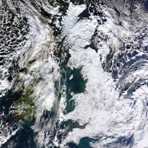
Some of you may remember seeing this NASA image of the entire UK covered in snow...something quite unusual.
HA!
NASA never took that photo it was ma buddy Scot from the University of Dundee, Scotland.
Sorry minor point but I have a story behind it of my friend sending me a e-mail with the photo attached telling me to look out for it in the next days news, its kind of been a running joke now because the guy never shuts up about it.
He would never forgive me if I let you away with claiming NASA took is precious photo….
edit on 6-1-2013 by OtherSideOfTheCoin because: (no reason given)edit on 6-1-2013 by OtherSideOfTheCoin because: (no reason given)
How did he take it? Because here's BBC's take on it.
news.bbc.co.uk...
This striking image taken by Nasa's Terra satellite on 7 January 2010 shows the UK deep in the clutches of the current cold snap.
EDIT: Nevermind. I see that the University of Dundee have access to a few of NASA's satelites and download the images that they take but I don't think that they have control of which pictures they actually take, Or do they?
edit on 6-1-2013 by RMFX1 because: (no reason given)
reply to post by RMFX1
I think he is trying to crack a joke, or be funny in some way.
The author of the photo is: Jeff Schmaltz, MODIS Rapid Response Team, Goddard Space Flight Center.
Source
I think he is trying to crack a joke, or be funny in some way.
The author of the photo is: Jeff Schmaltz, MODIS Rapid Response Team, Goddard Space Flight Center.
Source
edit on 6/1/13 by woogleuk because: (no reason given)
I'm gonna build a Snowman
Oh and a Snowcat (for my kitty to kill)
Oh and a Snowcat (for my kitty to kill)
thanks for the heads up buddy, as an NHS home carer i have to walk around town most of the day so obviously this will affect me doesnt help that im
having to do a tonne of extra work to pay off the council tax highland council if your reading this, i hate you i remember walking around
town in the winter of 2010, was nearly in tears by the end of the shift because i was frozen solid and soaked to the skin
Snow is great for the first week after that it becomes a pain
My kids love the snow and its a great chance to be in the garden with them making snowmen and having snowball fights. Seeing my youngest child have there first experience in the snow is one of the most amazing feelings one can have.
My kids love the snow and its a great chance to be in the garden with them making snowmen and having snowball fights. Seeing my youngest child have there first experience in the snow is one of the most amazing feelings one can have.
reply to post by boymonkey74
Last time we had any decent snow round here on the North west coast was 2009 or 2010 (I forget)....
...but I built myself a little snow buddy, he was awesome!
Had to censor the image as last time I posted this pic on ATS, one of the mods took offense at his snow balls.
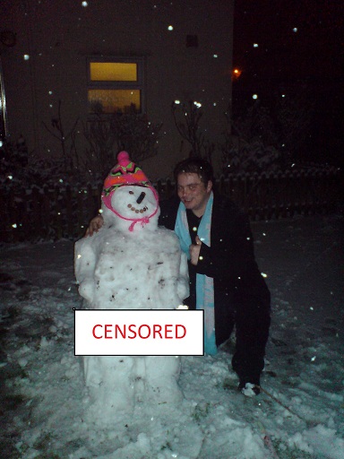
EDIT: For the record, they were the wifes idea, not mine!
Last time we had any decent snow round here on the North west coast was 2009 or 2010 (I forget)....
...but I built myself a little snow buddy, he was awesome!
Had to censor the image as last time I posted this pic on ATS, one of the mods took offense at his snow balls.
EDIT: For the record, they were the wifes idea, not mine!
edit on 6/1/13 by woogleuk because: (no reason given)
reply to post by jrmcleod
Thanks for the heads up. I read the same prediction via a weather forum posted on Facebook earlier today.
Duncan
London.
Thanks for the heads up. I read the same prediction via a weather forum posted on Facebook earlier today.
Duncan
London.
Advanced Warning Of Snow and Deep Cold Arriving in the UK... or = the earth's axis has shifted.
www.abovetopsecret.com...
www.abovetopsecret.com...
Sorry haven't read the entire thread yet but as long as its deep enough in Essex to close my tesco store 2 foot plus please
new topics
-
Late Night with the Devil - a really good unusual modern horror film.
Movies: 15 minutes ago -
Cats Used as Live Bait to Train Ferocious Pitbulls in Illegal NYC Dogfighting
Social Issues and Civil Unrest: 1 hours ago -
The Good News According to Jesus - Episode 1
Religion, Faith, And Theology: 3 hours ago -
HORRIBLE !! Russian Soldier Drinking Own Urine To Survive In Battle
World War Three: 5 hours ago -
Bobiverse
Fantasy & Science Fiction: 8 hours ago -
Florida man's trip overseas ends in shock over $143,000 T-Mobile phone bill
Social Issues and Civil Unrest: 8 hours ago -
Former Labour minister Frank Field dies aged 81
People: 10 hours ago
top topics
-
President BIDEN Vows to Make Americans Pay More Federal Taxes in 2025 - Political Suicide.
2024 Elections: 17 hours ago, 19 flags -
Florida man's trip overseas ends in shock over $143,000 T-Mobile phone bill
Social Issues and Civil Unrest: 8 hours ago, 8 flags -
SETI chief says US has no evidence for alien technology. 'And we never have'
Aliens and UFOs: 12 hours ago, 7 flags -
Cats Used as Live Bait to Train Ferocious Pitbulls in Illegal NYC Dogfighting
Social Issues and Civil Unrest: 1 hours ago, 4 flags -
Former Labour minister Frank Field dies aged 81
People: 10 hours ago, 4 flags -
Bobiverse
Fantasy & Science Fiction: 8 hours ago, 3 flags -
This is our Story
General Entertainment: 15 hours ago, 3 flags -
HORRIBLE !! Russian Soldier Drinking Own Urine To Survive In Battle
World War Three: 5 hours ago, 2 flags -
Late Night with the Devil - a really good unusual modern horror film.
Movies: 15 minutes ago, 1 flags -
The Good News According to Jesus - Episode 1
Religion, Faith, And Theology: 3 hours ago, 0 flags
active topics
-
-@TH3WH17ERABB17- -Q- ---TIME TO SHOW THE WORLD--- -Part- --44--
Dissecting Disinformation • 650 • : angelchemuel -
Thousands Of Young Ukrainian Men Trying To Flee The Country To Avoid Conscription And The War
Other Current Events • 135 • : twistedpuppy -
President BIDEN Vows to Make Americans Pay More Federal Taxes in 2025 - Political Suicide.
2024 Elections • 89 • : DBCowboy -
Late Night with the Devil - a really good unusual modern horror film.
Movies • 0 • : devilhunter69 -
New whistleblower Jason Sands speaks on Twitter Spaces last night.
Aliens and UFOs • 52 • : 0bserver1 -
SETI chief says US has no evidence for alien technology. 'And we never have'
Aliens and UFOs • 33 • : 0bserver1 -
Mood Music Part VI
Music • 3099 • : BrucellaOrchitis -
HORRIBLE !! Russian Soldier Drinking Own Urine To Survive In Battle
World War Three • 20 • : budzprime69 -
Cats Used as Live Bait to Train Ferocious Pitbulls in Illegal NYC Dogfighting
Social Issues and Civil Unrest • 2 • : Cre8chaos79 -
Florida man's trip overseas ends in shock over $143,000 T-Mobile phone bill
Social Issues and Civil Unrest • 14 • : Raptured