It looks like you're using an Ad Blocker.
Please white-list or disable AboveTopSecret.com in your ad-blocking tool.
Thank you.
Some features of ATS will be disabled while you continue to use an ad-blocker.

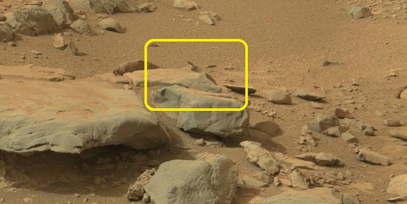
"Yellowknife Bay" Curiosity Drill Area: I've found the "KNIFE"...
page: 1share:
NASA’s Curiosity rover continues to explore the Martian surface, approaching an area called “Yellowknife Bay”. Who and When names this place on
Mars? And, first of all: WHY so? "When" and "Why", are very important questions because, if that area was called so, before the Rover came in, well,
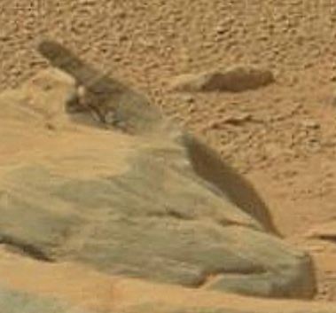
then, again, Curiosity is the luckiest Rover ever! There is "something" like a KNIFE in that area!
gigapan.com...
What a wonderful coincidence!
gigapan.com...
What a wonderful coincidence!
edit on 5-1-2013 by Arken because: (no reason given)
Originally posted by denver22
reply to post by Arken
Can i ask why you think that is a knife? what reason would you think that?..
Hmmmm... wait...
Maybe because that thing is "someting like a knife" and it is right in the middle of an area called "Yellowknife"?
Originally posted by Arken
Originally posted by denver22
reply to post by Arken
Can i ask why you think that is a knife? what reason would you think that?..
Hmmmm... wait...
Maybe because that thing is "someting like a knife" and it is right in the middle of an area called "Yellowknife"?
But it isn't yellow.
Originally posted by Arken
Hmmmm... wait...
Maybe because that thing is "someting like a knife" and it is right in the middle of an area called "Yellowknife"?
Maybe they saw a shadow that resembled a "knife" and called it "yellowknife" hmmmm..?
edit on 5-1-2013 by denver22 because: (no reason
given)
Originally posted by denver22
Originally posted by Arken
Hmmmm... wait...
Maybe because that thing is "someting like a knife" and it is right in the middle of an area called "Yellowknife"?
Maybe they saw a shadow that resembled a "knife" and called it "yellowknife" hmmmm..?edit on 5-1-2013 by denver22 because: (no reason given)
Exact. So: WHEN they called this area with this name?
It's a shadow because the patterns on "the knife" match exactly the patterns in the background sand.
You do realize that's just a shadow on the side of that rock and not an object right? If the picture were taken a few inches in any direction, the
"knife" wouldn't be there.
I know you think it's highly suspicious...but why/how would NASA name a Martian region after a shadow on a rock?
I know you think it's highly suspicious...but why/how would NASA name a Martian region after a shadow on a rock?
edit on 5-1-2013 by Hawking
because: (no reason given)
I believe there is a place called Yellowknife in Canada.
prbly named after that.
prbly named after that.
It was named "Yellowknife Bay" during the initial planning stages of the operation by a secretive group of Nasa cyborgs and time traveling atlantean
space engineers who, in a very super villain fashion, cast down a 'yellow knife' upon a map of mars and boldly declared "This is where man's journey
beyond the stars ends."
edit on 5-1-2013 by Thorneblood because: (no reason given)
edit on 5-1-2013 by Thorneblood because:
think before you type
I enjoy looking at any of these pictures of Mars. The Rover really has to pick its way through some pretty large rocks and ancient-Indian artifacts
like scraping knives and hammers, so I hope NASA knows a direct route to the foothills or else it may bump into a rock/point barrier/cache which can
make for some long drive-arounds. I suppose the route is mapped from the sky, and a path is already in place.
The site is named after Yellowknife Bay in Canada: en.wikipedia.org...
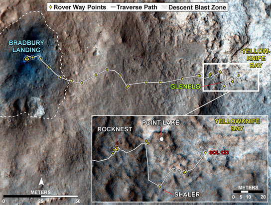
It has been named so quite a while ago, certainly before the rover reached it. I'll try to find the earliest mention.
P.S, it might be this, the article from Dec 11 2012: mars.jpl.nasa.gov...
It has been named so quite a while ago, certainly before the rover reached it. I'll try to find the earliest mention.
P.S, it might be this, the article from Dec 11 2012: mars.jpl.nasa.gov...
edit on
5-1-2013 by wildespace because: (no reason given)
Originally posted by wildespace
The site is named after Yellowknife Bay in Canada: en.wikipedia.org...
It has been named so quite a while ago, certainly before the rover reached it. I'll try to find the earliest mention.
P.S, it might be this, the article from Dec 11 2012: mars.jpl.nasa.gov...edit on 5-1-2013 by wildespace because: (no reason given)
Thanks for this wildespace.
So NASA/JPL called "Yellowknife Bay" before the rover reached that area....
Hmmm....
Or Curiosity is the luckiest NASA Rover ever... or they were secretely already in that area...
Could have also named it bay of piggy.
Anyone else notice the little piggy at the 4'o clock position of the yellow square ?
Anyone else notice the little piggy at the 4'o clock position of the yellow square ?
reply to post by Arken
Personally, I don't see anything resembling a knife there. I think you're making a big issue out of nothing, using just a stretch of imagination.
Here are images of that site taken at a different time of the day:
mars.jpl.nasa.gov...
mars.jpl.nasa.gov...
Do you see a knife there?
P.S. plug plug my panorama: photosynth.net...
What interests me more is why there are missing images? Have they found something they don't want us to see? o.o
edit on 5-1-2013 by wildespace
because: (no reason given)
Originally posted by Arken
So NASA/JPL called "Yellowknife Bay" before the rover reached that area....
Hmmm....
Or Curiosity is the luckiest NASA Rover ever... or they were secretely already in that area...
I don't understand your puzzlement. The "knife" isn't yellow, and the "knife" isn't really a single object, but instead just the way various shadows appear when viewed from this direction.
There are a lot of shapes of things that could be found in those rocks. Like the person above me said that he sees a pig. So if they would have called if "Pig Bay", he could have said, just like you said:
"Or Curiosity is the luckiest NASA Rover ever... or they were secretely already in that area... "
Again, the various shadows that make up that thing that you believe looks like a knife are not one continuous shadow on the same plane, but rather different pieces on different planes. So (considering your conspiracy theory), if NASA was secretly there in the past, they would need to be looking from that very some spot, at the very same time of day (sun angle), with their camera at that very same height, and viewing it at that exact same angle to see this "knife" (which, frankly, I can barely make out as a knife -- and probably only because you put that notion in my head).
Here's the actual reason it was called "Yellowknife Bay":
The whole landing area was named "Yellowknife" because Yellowknife, Canada, is known by geologists as the starting point for many geological expeditions to that part of Canada -- and area which holds a wealth of information to geologists:
The moniker is a tribute to the capital of Canada's Northwest Territories, a city that has long served as the jumping-off point for geologists interested in studying North America's oldest rocks, scientists said.
"If you ask, 'What is the port of call you leave from to go on the great missions of geological mapping to the oldest rocks in North America?' — it's Yellowknife," Curiosity chief scientist John Grotzinger, of Caltech in Pasadena, told reporters Friday (Aug. 10).
So it makes perfectly good sense why the landing area was named "Yellowknife". This smaller part named "Yellowknife Bay" of Mars' Yellowknife was probably named "Yellowknife Bay" because if the way the topography suddenly drops off into something that looks bay-like.
Source of excerpt above
edit on 1/5/2013 by Soylent Green Is People because: (no reason given)
Originally posted by wildespace
What interests me more is why there are missing images? Have they found something they don't want us to see? o.o
I'm not sure if you're being serious or not, but it's likely that not all the images were there at the time when you assembled your panorama. It can take days to get all the images. Go back and see if the missing images are there.
A member named iMPREPREX at unmannedspaceflight.com was able to complete his version here
new topics
-
The functionality of boldening and italics is clunky and no post char limit warning?
ATS Freshman's Forum: 10 minutes ago -
Meadows, Giuliani Among 11 Indicted in Arizona in Latest 2020 Election Subversion Case
Mainstream News: 45 minutes ago -
Massachusetts Drag Queen Leads Young Kids in Free Palestine Chant
Social Issues and Civil Unrest: 1 hours ago -
Weinstein's conviction overturned
Mainstream News: 2 hours ago -
Supreme Court Oral Arguments 4.25.2024 - Are PRESIDENTS IMMUNE From Later Being Prosecuted.
Above Politics: 3 hours ago -
Krystalnacht on today's most elite Universities?
Social Issues and Civil Unrest: 3 hours ago -
Chris Christie Wishes Death Upon Trump and Ramaswamy
Politicians & People: 4 hours ago -
University of Texas Instantly Shuts Down Anti Israel Protests
Education and Media: 6 hours ago -
Any one suspicious of fever promotions events, major investor Goldman Sachs card only.
The Gray Area: 8 hours ago
top topics
-
VP's Secret Service agent brawls with other agents at Andrews
Mainstream News: 17 hours ago, 11 flags -
Krystalnacht on today's most elite Universities?
Social Issues and Civil Unrest: 3 hours ago, 7 flags -
Weinstein's conviction overturned
Mainstream News: 2 hours ago, 6 flags -
Supreme Court Oral Arguments 4.25.2024 - Are PRESIDENTS IMMUNE From Later Being Prosecuted.
Above Politics: 3 hours ago, 5 flags -
Electrical tricks for saving money
Education and Media: 16 hours ago, 5 flags -
University of Texas Instantly Shuts Down Anti Israel Protests
Education and Media: 6 hours ago, 3 flags -
Meadows, Giuliani Among 11 Indicted in Arizona in Latest 2020 Election Subversion Case
Mainstream News: 45 minutes ago, 3 flags -
Any one suspicious of fever promotions events, major investor Goldman Sachs card only.
The Gray Area: 8 hours ago, 2 flags -
Massachusetts Drag Queen Leads Young Kids in Free Palestine Chant
Social Issues and Civil Unrest: 1 hours ago, 2 flags -
God's Righteousness is Greater than Our Wrath
Religion, Faith, And Theology: 13 hours ago, 1 flags
active topics
-
Supreme Court Oral Arguments 4.25.2024 - Are PRESIDENTS IMMUNE From Later Being Prosecuted.
Above Politics • 51 • : Threadbarer -
University of Texas Instantly Shuts Down Anti Israel Protests
Education and Media • 146 • : KrustyKrab -
Meadows, Giuliani Among 11 Indicted in Arizona in Latest 2020 Election Subversion Case
Mainstream News • 2 • : xuenchen -
VP's Secret Service agent brawls with other agents at Andrews
Mainstream News • 53 • : confuzedcitizen -
Massachusetts Drag Queen Leads Young Kids in Free Palestine Chant
Social Issues and Civil Unrest • 6 • : AstralFury -
Cats Used as Live Bait to Train Ferocious Pitbulls in Illegal NYC Dogfighting
Social Issues and Civil Unrest • 21 • : confuzedcitizen -
The functionality of boldening and italics is clunky and no post char limit warning?
ATS Freshman's Forum • 1 • : xuenchen -
The Anunnaki and the Matrix of Lies. The Missing Links.
Ancient & Lost Civilizations • 754 • : JonnyC555 -
Biden--My Uncle Was Eaten By Cannibals
US Political Madness • 74 • : xuenchen -
Weinstein's conviction overturned
Mainstream News • 17 • : 5thHead