It looks like you're using an Ad Blocker.
Please white-list or disable AboveTopSecret.com in your ad-blocking tool.
Thank you.
Some features of ATS will be disabled while you continue to use an ad-blocker.

Japan Preliminary Earthquake Maps NIED
page: 4share:
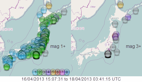
click the image for interactive map
Summary
mag1= 183
mag2= 184
mag3= 26
mag4= 11
mag5= 2
mag6= 2
mag7= 0
total= 408
TTNT= 66,619.311
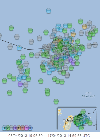
NIED don't catch the Ryuku Islands, there is a swarm going on there just NE out of Taiwan, will have to wait 3 days for the Reviewed data from JMA
Ryuku Islands data starting to come in, has built up with minor quakes until the 17th when the six mag 5's hit in just under an hour.
MagML, When, Lat, Long, Depthkm
5.0, 17/04/2013 05:57:59, 24.883, 123.308, 19
5.0, 17/04/2013 06:18:17, 24.882, 123.276, 20
5.3, 17/04/2013 06:33:48, 24.881, 123.266, 22
5.1, 17/04/2013 06:39:08, 24.878, 123.26, 14.4
5.5, 17/04/2013 06:43:00, 24.866, 123.315, 25
5.6, 17/04/2013 06:50:20, 24.853, 123.32, 18
This data is reviewed by JMA and is up till 17/04/2013 14:59:58 (as it says on the image )
Data is retrived from NIED/JMA using the "NW OFF ISHIGAKIJIMA" IS and "NEAR ISHIGAKIJIMA ISLAND" parameters
[color=lime](click image for interactive map, opens in new tab/window)
Summary
mag1= 84
mag2= 103
mag3= 76
mag4= 8
mag5= 9
mag6= 0
mag7= 0
total= 280
TTNT 15595.09965

edit on 18-4-2013 by muzzy because: text file especially for Bo Xian
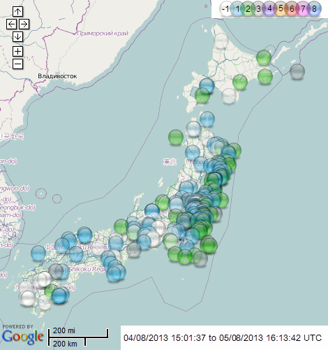
summary
mag
(click image for interactive map,
opens in new tab/window)
opens in new tab/window)
ID: NIEDU20140106-249 Network: nied
Date/Time UTC: 06/01/2014 08:18:00
Date/Time JST: 06/01/2014 17:18:00
Latitude, Longitude: 36.2366, 138.8062
Magnitude: 4.3ML
Energy Released (TTNT): 42.50190
Depth: 142.6km
Location: Nanjai, Eastern Honshu. Japan
Status: preliminary
edit on 010000005514 by muzzy because: (no reason given)
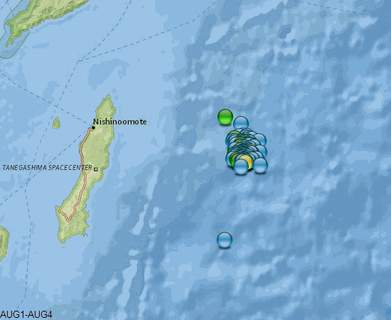
This caught my eye this morning
4.7-04/08/2015 04:39:47
Lat/Long: 30.647, 131.605
UTC: 04/08/2015 04:39:47
JST: 04/08/2015 13:39:47
Depth: 37.9
Mag: 4.7 ML
Location: E OFF TANEGASHIMA ISLAND
Energy Released: 169.2031 tonnes of TNT
Source: JMA Status: reviewed
further research finds a recent series of earthquakes off Tanega Island over the last 4 days.
search area is Lat/ Long 30.929, 130.89, 30.245,131.965
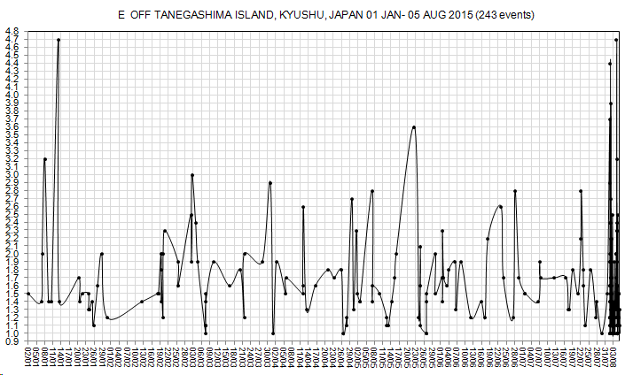
firstly going back to Jan 1st 2015, a graph of the activity
rightclickviewimage for full size
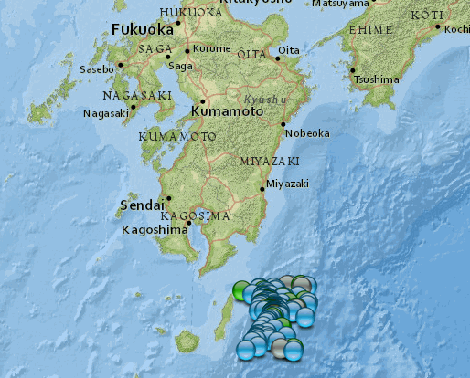
then the location map of that graph, for those who didn't already know where Tanega Island was ( I didn't)

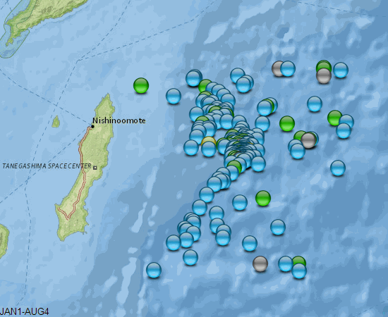
closer map, showing the locations of the events on the graph
even closer
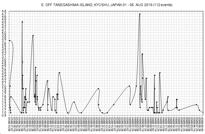
now the latest "upkick" in activity, graph
rightclickviewimage for full size
and a mp of where those were in relation to the previous whole 6 months map

animation
how about the history of the area?
ANSS search same co-ordinates since 10/5/1963
largest events
18/10/1996, 6.8
24/01/1999, 6.4
map of those
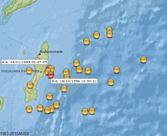
and another animation comparing the current series with the history
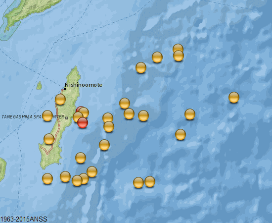
Based on 52 years of history there is only a 7.1% chance it will end up with a M6+ in that immediate area
4.7-04/08/2015 04:39:47
Lat/Long: 30.647, 131.605
UTC: 04/08/2015 04:39:47
JST: 04/08/2015 13:39:47
Depth: 37.9
Mag: 4.7 ML
Location: E OFF TANEGASHIMA ISLAND
Energy Released: 169.2031 tonnes of TNT
Source: JMA Status: reviewed
further research finds a recent series of earthquakes off Tanega Island over the last 4 days.
search area is Lat/ Long 30.929, 130.89, 30.245,131.965
firstly going back to Jan 1st 2015, a graph of the activity
rightclickviewimage for full size
then the location map of that graph, for those who didn't already know where Tanega Island was ( I didn't)
closer map, showing the locations of the events on the graph
even closer
now the latest "upkick" in activity, graph
rightclickviewimage for full size
and a mp of where those were in relation to the previous whole 6 months map
animation
how about the history of the area?
ANSS search same co-ordinates since 10/5/1963
largest events
18/10/1996, 6.8
24/01/1999, 6.4
map of those
and another animation comparing the current series with the history
Based on 52 years of history there is only a 7.1% chance it will end up with a M6+ in that immediate area
edit on 0800000021721715 by muzzy because: got a couple of images mixed up, fixed it
edit on 0800000021721715 by muzzy
because: (no reason given)
new topics
-
University student disciplined after saying veganism is wrong and gender fluidity is stupid
Education and Media: 1 hours ago -
Geddy Lee in Conversation with Alex Lifeson - My Effin’ Life
People: 2 hours ago -
God lived as a Devil Dog.
Short Stories: 2 hours ago -
Police clash with St George’s Day protesters at central London rally
Social Issues and Civil Unrest: 3 hours ago -
TLDR post about ATS and why I love it and hope we all stay together somewhere
General Chit Chat: 4 hours ago -
Hate makes for strange bedfellows
US Political Madness: 6 hours ago -
Who guards the guards
US Political Madness: 9 hours ago -
Has Tesla manipulated data logs to cover up auto pilot crash?
Automotive Discussion: 11 hours ago
top topics
-
Hate makes for strange bedfellows
US Political Madness: 6 hours ago, 14 flags -
Who guards the guards
US Political Madness: 9 hours ago, 13 flags -
whistleblower Captain Bill Uhouse on the Kingman UFO recovery
Aliens and UFOs: 16 hours ago, 11 flags -
Police clash with St George’s Day protesters at central London rally
Social Issues and Civil Unrest: 3 hours ago, 7 flags -
TLDR post about ATS and why I love it and hope we all stay together somewhere
General Chit Chat: 4 hours ago, 5 flags -
University student disciplined after saying veganism is wrong and gender fluidity is stupid
Education and Media: 1 hours ago, 3 flags -
Has Tesla manipulated data logs to cover up auto pilot crash?
Automotive Discussion: 11 hours ago, 2 flags -
God lived as a Devil Dog.
Short Stories: 2 hours ago, 2 flags -
Geddy Lee in Conversation with Alex Lifeson - My Effin’ Life
People: 2 hours ago, 2 flags