It looks like you're using an Ad Blocker.
Please white-list or disable AboveTopSecret.com in your ad-blocking tool.
Thank you.
Some features of ATS will be disabled while you continue to use an ad-blocker.

Google Earth: Am I going crazy or is there some freaky stuff out in the desert???
page: 3share:
reply to post by Drunkenparrot
Most certainly and elephant's cage antenna would be spotted from Tikaboo. However it is an entertaining suggestion since few people have ever seen one in the flesh. I think one of the last surviving antennas was somewhere around San Diego, but I believe that is long gone.
Near the Tonopah FAA site, there is the remnants of some sort of loop antenna.
38° 8'36.82"N 117°11'55.41"W
The telephone poles are still there is a round pattern, but no wire. You can't see the poles, but the shadows from the poles are very visible. Nellis owns this part of the hill, but the antenna could have been for the Army or Army Air Force.
Back to the last elephant cage:
en.wikipedia.org...
32°35'36.59"N 117° 7'44.90"W for the center of the elephant cage
The wiki says it was supposed to be torn down, but it is still there apparently.
reply to post by gariac
reply to post by weavty1
Thanks for the correction, it looked similar to an old overhead photo of an elephant cage array I had seen in a discussion regarding a circular structure at Dugway.
Gariac, the panorama photo you linked in the Google earth discussion is incredible. I have visited your site a few times and somehow overlooked that gem.
Whatever its purpose, referencing the Google earth historical imagery shows it wasn't there on 6/6/2002 but was by 11/13/2006.
That would rule out anything A12 related.
The older photos also show the chaotic yellow striping much better as per Weavty1's post above.
I would also add that baring elaborate Hollywood style PSYOP's, the various satellite views available make it clear that Groom is a very busy and relevant place .
I'm still waiting on the Cherry Point F-35 photos as well ( )
reply to post by Drunkenparrot
Regarding F-35's at Cherry Point... I personally saw two there myself, in September.
Not only is MCAS Cherry Point slated to be one of the IOC sites (initial operational ability) for the F-35 airframe, but here's something in writing for you guys and gals to browse over, regarding the F-35 there...
Cherry Point, NC - Fleet Readiness Center East
Just so we're all on the same page
edit on 1/2/2013 by weavty1 because: (no reason given)
Originally posted by weavty1
reply to post by Drunkenparrot
Regarding F-35's at Cherry Point... I personally saw two there myself, in September.
Not only is MCAS Cherry Point slated to be one of the IOC sites (initial operational ability) for the F-35 airframe, but here's something in writing for you guys and gals to browse over, regarding the F-35 there...
Cherry Point, NC - Fleet Readiness Center East
Just so we're all on the same pageedit on 1/2/2013 by weavty1 because: (no reason given)
Interesting, you are the second person posting in this thread to say that.
The general consensus has been skeptical as officially all of the F-35's were still at Eglin in Florida when the claim was made.
You know the Marine Corps just received the first 3 F-35B's at MCAS Yuma in mid November? Also, Cherry Point F-35 operations are still a long way out. So much in fact the USMC just extended their Harrier mission at MCAS Cherry Point...
Concerns over the viability and longevity of Cherry Point and Fleet Readiness Center East have been on the minds of residents and area leaders for some time with talk of a Base Realignment and Closure Commission and possible sequestration.
But the clouds of doom and gloom parted last week enough for a little positive light to shine through when a local leader attending a Washington, D.C., symposium stood up to voice her concerns for Cherry Point in front of James F. Amos, Commandant of the Marine Corps.
“He said Cherry Point doesn’t have anything to worry about,” said Stephanie Duncan, executive director of the Havelock Chamber of Commerce.....
Duncan said Amos informed her that Cherry Point’s AV-8B Harrier squadrons, scheduled to be deactivated starting in 2019, would be extended to meet with the planned arrival of the first F-35B Joint Strike Fighter squadrons in as early as 2021 or 2022.
Harriers at Cherry Point extended to meet incoming F-35s
Official welcoming ceremonies at Yuma marked the handover of the jets to the Marines. The delivery of the first three operational-coded 5th generation F-35B STOVL fighters marks the beginning of STOVL tactical operational training at Air Station Yuma.
These three aircraft increase the number of STOVL aircraft delivered to the Marine Corps to 16 and bring the total number of F-35s delivered in 2012 to 20. Currently, 13 Marine Corps STOVLs are assigned to the 2nd Marine Aircraft Wing's Marine Fighter/Attack Training Squadron 501 at Eglin AFB, Fla., supporting pilot and maintainer training.[
Lockheed Martin delivers three F-35Bs to the USMC
There is a lot on the internet about the F-35 being stationed Cherry Point at some future point but nothing about anyone having seen one there in the present.
Can you provide a link to something that supports your claim?
I am by no means saying it is beyond the realm of possibility and admittedly, I live on the other side of the country, however just because somebody on the internet says so doesn't make it true.
Look at how quickly pictures of the J-20 and J-31 made their way onto the internet and out of the PRC. With the global aviation fanboy culture (myself very much included) as it is and speed of information sharing I would expect to see at least a photo from someone?
Originally posted by Zaphod58
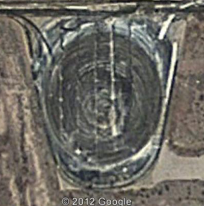
The last one is an Alfalfa farm with an automatic watering system that rolls around the field. The others I'm not sure on yet.
Really? An Alfalfa farm with five automatic watering systems? Alfalfa must be fetching a fair price these days. Looks to me more like a HAARP type installation........
reply to post by Drunkenparrot
Note that the older imagery is shifted a bit. The pit (or whatever) can be found at
37°14'2.50"N 115°48'40.13"W
It does look different.
I would say a relevant question is what did the SR-71 bases do to handle fuel leaks? There should be a similar structure to handle the same fuel leak issue.
Note that the older imagery is shifted a bit. The pit (or whatever) can be found at
37°14'2.50"N 115°48'40.13"W
It does look different.
I would say a relevant question is what did the SR-71 bases do to handle fuel leaks? There should be a similar structure to handle the same fuel leak issue.
reply to post by PlanetXisHERE
If you look through the desert, there are dozens of alfalfa farms that look a lot like that does. All of a sudden, in the middle of sandy desert, there's this big round green patch. I was wrong in this case, because it was late, and I didn't look to see where it was in relation to the base. Oh well, not the first time I've been wrong, won't be the last.
If you look through the desert, there are dozens of alfalfa farms that look a lot like that does. All of a sudden, in the middle of sandy desert, there's this big round green patch. I was wrong in this case, because it was late, and I didn't look to see where it was in relation to the base. Oh well, not the first time I've been wrong, won't be the last.
reply to post by weavty1
Except the claim was that they were bedding them down at the Wilmington Regional Airport, and flying out of there, not Cherry Point. There is a big refueling contract with an FBO at Wilmington, but I seriously doubt they were bedding them down there. Those are the pics we're waiting on.
Except the claim was that they were bedding them down at the Wilmington Regional Airport, and flying out of there, not Cherry Point. There is a big refueling contract with an FBO at Wilmington, but I seriously doubt they were bedding them down there. Those are the pics we're waiting on.
reply to post by gariac
The debate about this feature is very puzzling. It is a flat concrete pad that was formerly used as the Compass Rose, according to official documents. It is not a pit or antenna farm, or anything else. In recent years, after that taxiway was bypassed by the new Center Taxiway, these stains started showing up. They have become more pronounced over time, indicating some sort of activity (though probably not anything particularly interesting).
It certainly has nothing to do with fuel leaks. Apropos of nothing, Blackbird (A-12, YF-12, SR-71) fuel leakage was addressed by the simple expedient of placing pans and buckets under the aircraft while it was parked.
reply to post by Zaphod58
Beat me to it. Supposedly they were 60 feet or something away from a small fence at the local airport, not cherry point. And no security present there either.
Beat me to it. Supposedly they were 60 feet or something away from a small fence at the local airport, not cherry point. And no security present there either.
Actually it is a pit when I look at it with my GIS software. Topography shows it to be about 30 feet deep (disclosure: I've earned my BS in general
geography with two minors, one minor in geoscience, and the other in GIS. Also I emailed ESRI to obtain permission to post the measurements and
screenshots I used with their software((big fine!!!))). I honestly don't know what it is. But it is a pit of somekind, or the software mapping is
inaccurate. Theres other things around the actual lake bed itself thats cool to see with GIS. it appears that there are some features in the side of a
hill that look like they used to be hangers that are now filled in with dirt.
reply to post by boomer135
Big fine for what? Posting a screenshot? It wouldn't be a fine, because they aren't a government body or sanction - Privately held company.
Or am I missing something? lol
Big fine for what? Posting a screenshot? It wouldn't be a fine, because they aren't a government body or sanction - Privately held company.
Or am I missing something? lol
reply to post by boomer135
FWIW, the oldest imagery makes it look flat, but the subsequent images make it look like a pit. There is no question there is some sort of infrastructure over the area, running perpendicular to the old taxiway.
The hole is 60x30 meters. The USGS DEMs are 1 arcsecond, which is approximately 30 meters. If your software says there is a hole there, there probably is. Maybe not exactly 30ft unless they got that data from something other than the USGS DEMs. The size of the hole is close to the DEM grid.
The USGS DEMs are online, but I don't know any easy way to read the height at a particular location. [You can get the height at a particular coordinate with SPLAT!] Note that Google Earth uses the DEMs, so if you think there is a funny spot on a hill, we can look if you give us the coordinates. If you look at GE imagery in 3D carefully, often the peaks are off a little bit. You see antennas on the sides of hills instead of top. GE isn't all that accurate, but there is no better free service.
reply to post by Shadowhawk
Now to back up the theory that is was a compass rose, the north/south line is at 14 degrees, which is the magnetic variation for that part of Nevada. But you see that only in the 2002 imagery. It is no longer there in 2006. In 2006, there are rings in the pit that might have been used to support a tracked vehicle to dig a hole, like a bobcat. [There is a finite length of the arms on excavation equipment, so if they need to go deeper than the arm, they leave a pad to set the track on, then dig while on the pad.] By 2009, the perpendicular lines appear. [Presumably pipes with sprayers if you buy the pit theory.]
Now if the area was flat in 2002, that blows away the leaking A-12 fuel pit theory.
reply to post by gariac
ArcGIS isn't free except for the limited free trial offer but that doesn't give you half of the paid version. My guesstamation is based off of topography lines so its by no means accurate, just shows that there is a pit there. I'm leaning towards it being some sort of burn pit or perhaps a hazardous waste run off pit. Perhaps they wash some new chemicals off of a jet after every flight or something. Even better, maybe they have a space plane that can takeoff single stage to orbit and land normally and they need to wash it off after every flight!
ArcGIS isn't free except for the limited free trial offer but that doesn't give you half of the paid version. My guesstamation is based off of topography lines so its by no means accurate, just shows that there is a pit there. I'm leaning towards it being some sort of burn pit or perhaps a hazardous waste run off pit. Perhaps they wash some new chemicals off of a jet after every flight or something. Even better, maybe they have a space plane that can takeoff single stage to orbit and land normally and they need to wash it off after every flight!
reply to post by boomer135
I think they would want some distance from the main runways if they were going to burn the fuel. Maybe it is for de-ice collection. I've haven't flown in the winter in some time, but they deice right on the runway and I don't believe they collect the fluid. [There was an accident a few years ago where they deiced the plane, but it spent too much time on the ground post the procedure and then had a mishap. So now they deice right before takeoff.] There was some issue regarding the TTR where they claimed the deicing fluid was killing the wild horses, but then they blamed it on "natural" toxins.
The TTR has a bad reputation for tolerating wild animals. Supposedly they would put marks on vehicles that hit wild horses, like marking a kill on a warbird. The NTS on the other hand seems to do backflips for the wildlife. Based on scanning their repeater system, one guy had to wait for a mountain lion to leave his earth moving machine (skip loader or dozer, I forget). No rock throwing allowed.
The old Compass Rose pad has not been accessible to aircraft since the new Center Taxiway was built. Also, there hasn't been any burning of hazardous
waste since the lawsuit. The landfills were moved as far as possible from populated areas of the base, and there is greater EPA supervision. Aircraft
parking ramps that were contaminated with many years worth of spilled fuels, lubricants, and de-icing fluids have been excavated and replaced with
clean soil and new concrete.
I believe i have discovered underground facilities close to Area 51 using google earth. Two entrances to underground facilities are clear on the
folloiwng images:


When you go about 500 yards further to the south of these underground / hillside entrances you will see the large stockpile os as dug material which suggests it came out of the mountain - i.e the underground base must be a fair size,
Has any one ever noticed this area before, if sio what is it? Is this the famous S4 which bob lazar spoke out about lol?
new topics
-
WF Killer Patents & Secret Science Vol. 1 | Free Energy & Anti-Gravity Cover-Ups
General Conspiracies: 1 hours ago -
Hurt my hip; should I go see a Doctor
General Chit Chat: 2 hours ago -
Israel attacking Iran again.
Middle East Issues: 3 hours ago -
Michigan school district cancels lesson on gender identity and pronouns after backlash
Education and Media: 3 hours ago -
When an Angel gets his or her wings
Religion, Faith, And Theology: 4 hours ago -
Comparing the theology of Paul and Hebrews
Religion, Faith, And Theology: 5 hours ago -
Pentagon acknowledges secret UFO project, the Kona Blue program | Vargas Reports
Aliens and UFOs: 6 hours ago -
Boston Dynamics say Farewell to Atlas
Science & Technology: 6 hours ago -
I hate dreaming
Rant: 7 hours ago -
Man sets himself on fire outside Donald Trump trial
Mainstream News: 9 hours ago
top topics
-
The Democrats Take Control the House - Look what happened while you were sleeping
US Political Madness: 9 hours ago, 18 flags -
In an Historic First, In N Out Burger Permanently Closes a Location
Mainstream News: 11 hours ago, 16 flags -
A man of the people
Medical Issues & Conspiracies: 17 hours ago, 11 flags -
Man sets himself on fire outside Donald Trump trial
Mainstream News: 9 hours ago, 9 flags -
Biden says little kids flip him the bird all the time.
Politicians & People: 9 hours ago, 9 flags -
Michigan school district cancels lesson on gender identity and pronouns after backlash
Education and Media: 3 hours ago, 6 flags -
Pentagon acknowledges secret UFO project, the Kona Blue program | Vargas Reports
Aliens and UFOs: 6 hours ago, 6 flags -
WF Killer Patents & Secret Science Vol. 1 | Free Energy & Anti-Gravity Cover-Ups
General Conspiracies: 1 hours ago, 6 flags -
Israel attacking Iran again.
Middle East Issues: 3 hours ago, 5 flags -
Boston Dynamics say Farewell to Atlas
Science & Technology: 6 hours ago, 4 flags
active topics
-
MULTIPLE SKYMASTER MESSAGES GOING OUT
World War Three • 53 • : Zaphod58 -
Israel attacking Iran again.
Middle East Issues • 26 • : NorthOS -
Michigan school district cancels lesson on gender identity and pronouns after backlash
Education and Media • 8 • : TheMichiganSwampBuck -
I Guess Cloud Seeding Works
Fragile Earth • 29 • : Justoneman -
Man sets himself on fire outside Donald Trump trial
Mainstream News • 40 • : Vermilion -
When an Angel gets his or her wings
Religion, Faith, And Theology • 5 • : randomuser2034 -
Anyone one else having Youtube problems
Computer Help • 11 • : charlyv -
The Democrats Take Control the House - Look what happened while you were sleeping
US Political Madness • 68 • : Mahogani -
Candidate TRUMP Now Has Crazy Judge JUAN MERCHAN After Him - The Stormy Daniels Hush-Money Case.
Political Conspiracies • 404 • : Zanti Misfit -
In an Historic First, In N Out Burger Permanently Closes a Location
Mainstream News • 10 • : Degradation33