It looks like you're using an Ad Blocker.
Please white-list or disable AboveTopSecret.com in your ad-blocking tool.
Thank you.
Some features of ATS will be disabled while you continue to use an ad-blocker.

Google Earth: Am I going crazy or is there some freaky stuff out in the desert???
page: 1share:
Well here i was exploring google earth when I caught side of two huge mounds of earth being created a little west of groom. I followed one of the
roads leading from this place and it looks like a shape of an aircraft any true groom follower should have heard about. Am I losing it? Is this jet
burried under a tarp like they did back in the days? Or is there really a jet there?
Just for reference to groom: Actual coordinates are: 37°11'30.03"N 115°54'52.55"W
The craft is where "jet" is...

So here's the big mounds of dirt getting to be pretty commonplace around the NTS. Not sure what they are doing with them but it almost looks like the old RCS places in the middle...

Using a little google magic I can guestimate that they are appx 1300 feet by 700 feet and rise from 0 in the center to 50-60 feet on the rear effectively making it the largest halfpipe in the world. Here’s a pic of them in alignment with the mystery “spot”.

Now for the craft itself…Here’s the site from way above.

And here’s from a little closer:

And the finale!

So what is this? The rear of an Aurora type aircraft? Just an anomaly? Can you guys see if they are using some sort of tent structure? And what about the alignment with the center of the dunes there?
Lots of questions we probably wont have an answer to. Here’s some more info on the craft/rock/turd.

Any thoughts?
I actually found a lot of cool stuff I haven’t seen before. Here’s a couple…
Can anyone else see an alien throwing up a peace sign?

And finally, what the hell is this thing? Cause I’ve given up trying to find out…

Just for reference to groom: Actual coordinates are: 37°11'30.03"N 115°54'52.55"W
The craft is where "jet" is...
So here's the big mounds of dirt getting to be pretty commonplace around the NTS. Not sure what they are doing with them but it almost looks like the old RCS places in the middle...
Using a little google magic I can guestimate that they are appx 1300 feet by 700 feet and rise from 0 in the center to 50-60 feet on the rear effectively making it the largest halfpipe in the world. Here’s a pic of them in alignment with the mystery “spot”.
Now for the craft itself…Here’s the site from way above.
And here’s from a little closer:
And the finale!
So what is this? The rear of an Aurora type aircraft? Just an anomaly? Can you guys see if they are using some sort of tent structure? And what about the alignment with the center of the dunes there?
Lots of questions we probably wont have an answer to. Here’s some more info on the craft/rock/turd.
Any thoughts?
I actually found a lot of cool stuff I haven’t seen before. Here’s a couple…
Can anyone else see an alien throwing up a peace sign?
And finally, what the hell is this thing? Cause I’ve given up trying to find out…
edit on 25-12-2012 by boomer135 because: fixed pics
edit on 25-12-2012 by boomer135 because: (no reason
given)
edit on 25-12-2012 by boomer135 because: (no reason given)
The last one is an Alfalfa farm with an automatic watering system that rolls around the field. The others I'm not sure on yet.
Interesting finds.Especially that black hole you found.Are they all near eachother?
reply to post by boomer135
What I think is the most interesting thing going on there, is the length of the runway.
According to Google Earth's measuring tool, the runway there is 4.45 miles long.
But if you check Wikipedia, the longest runway in the world is in China's Qamdo Bamda Airport, which is 3.41 miles long.
Wikipedia
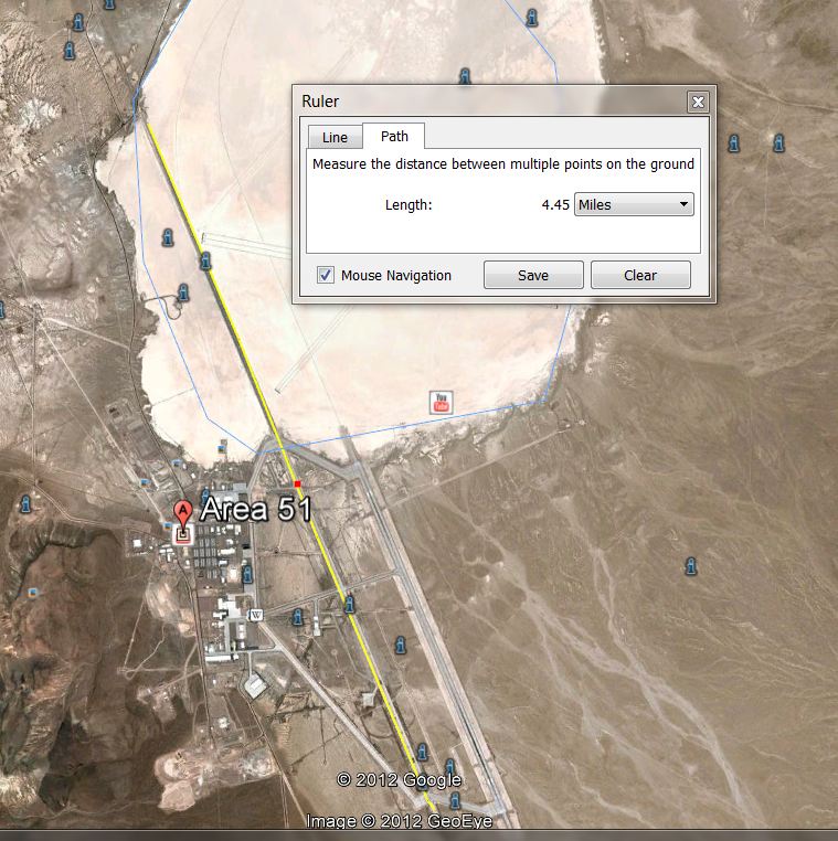
Raises all kinds of questions, doesn't it?
What I think is the most interesting thing going on there, is the length of the runway.
According to Google Earth's measuring tool, the runway there is 4.45 miles long.
But if you check Wikipedia, the longest runway in the world is in China's Qamdo Bamda Airport, which is 3.41 miles long.
Wikipedia
Raises all kinds of questions, doesn't it?
edit on 25-12-2012 by watchitburn because: (no reason given)
reply to post by watchitburn
That runway was extended in the last 10 years or so. There was a rumor a few years ago that there was a spaceplane/mothership combination flying out of Groom, and that was why the runway was so long.
That runway was extended in the last 10 years or so. There was a rumor a few years ago that there was a spaceplane/mothership combination flying out of Groom, and that was why the runway was so long.
With things like this, people see what they want to see, a little like optical illusions used in therapy, the doctor asks, what do you see.
To me, the majority of pictures are dirt formations, natural land textures.
To me, the majority of pictures are dirt formations, natural land textures.
It's a decoy. It's a big poster of a jet, intended to be seen from outer space. One of those holographic jet projections. NASA could have
photoshopped it there.
There is nothing freaky when it comes to jets in bases in the desert. Nothing to see here, go back to sleep.
There is nothing freaky when it comes to jets in bases in the desert. Nothing to see here, go back to sleep.
All I could see is dirt, then I hoped you might circle what you were pointing out op, but you only circled more dirt with an added line?
I'm not bashing you, I just can't see anything except dirt, maybe ive looked at too many mars rocks..
I'm not bashing you, I just can't see anything except dirt, maybe ive looked at too many mars rocks..
edit on 25/12/2012 by AlanQaida because:
(no reason given)
reply to post by Zaphod58
37°14'4.50"N 115°48'26.58"W
That is not an alfalfa farm. I can see how someone might think that until they saw the spot in context.
There is a google earth community marker indicating the area was used to drain fuel from leaky A-12s. That is as good as any other explanation since they were known to have such a problem.
reply to post by gariac
I suspect that it's more than just A-12 fuel that gets/got dumped in there. That's pretty big for just A-12 fuel.
I suspect that it's more than just A-12 fuel that gets/got dumped in there. That's pretty big for just A-12 fuel.
reply to post by boomer135
Those spots are just out of range of the NTS. Given how everyone guards their territory, I'd certainly attribute the area to either Nellis or Groom. I think it is just a landfill. OK, perhaps a classified land fill. The spot at the end of the road could be where they buried a plane.
I've seen the dirt haulers out near Gate 700 when on the NTS tour. It wouldn't surprise me if the landfill used an outside company to put the layers of dirt over the trash. The trash would probably be in containers, so it isn't like anything secret will be revealed to the outsiders.
The NTTR buys old cargo containers. They use them to build bombing targets. But I could see a container here or there being used to store trash then eventually it gets buried. If you containerize it, you can always go back and dig up something if need be.
This is a mock ICBM facility using cargo containers, as seen from Tikaboo Peak.
But it could easily be a prison with guard towers or the minarets of a mosque. The ICBM info is something I found in a Nellis document. But the idea is to shoot it up, which they do. I've watched this from Tikaboo. The IR tracer rounds makes it look like a laser. The tracer fire can be seen off the range around the ET Highway.
Lots of ordinary stuff can look spooky if you don't know what's happening, so it is always best to visit the range with a scanner.
reply to post by Zaphod58
Perhaps deice fluid. Who knows.
Given the pyros antics of yesteryear of the base, they probably would collect the fuel then burn it in the same pit when appropriate. So you would want the pit to be reasonably deep to contain the fire.
If you read the thread, it wasn't my idea, but it does make sense. If you wanted to collect something in a pit not related to aviation, you wouldn't do it by the runway. So the pit is aircraft related. The Roadrunners would know for sure.
reply to post by gariac
Oh, I know it wasn't your idea. I was just saying that there had to be more than just fuel from the A-12 in there. I'd love to be able to sit down with the Road Runners for a nice long chat, and see what if anything they'd talk about.
Oh, I know it wasn't your idea. I was just saying that there had to be more than just fuel from the A-12 in there. I'd love to be able to sit down with the Road Runners for a nice long chat, and see what if anything they'd talk about.
reply to post by Zaphod58
the first one looks like salt flats\shalloow lake ive seen one and the water is a white color like that with the sun reflecting off it when its dry the mud is white as well
the first one looks like salt flats\shalloow lake ive seen one and the water is a white color like that with the sun reflecting off it when its dry the mud is white as well
reply to post by Zaphod58
The Roadrunners have opened their meetings, or at least the annual ones, to the public in the last few years. If it isn't a secret, they will tell you what you want to know. That was where I picked up on "Have Glib" being used at Groom Lake and then later the TTR. In retrospect, Tom Mahood's revelation that working the radar sites at the TTR was only done by Janet passengers should have clued us in that they were somewhat Groom related.
"Have Glib" is one of the worst internet search items. The false positive hit is huge. Glib is a linux library and an English word. Word like "have" are generally not used in searches. I spent some time at the CIA archive digging up info on "Have Glib", and their search engine is no better regarding false positives.
If you don't recall, "Have Glib" is a foreign radar exploitation program. If you hang out at the TTR enough, you will see white world aircraft fly over the foreign radar at Site-4. I don't know the level of sophistication in RWR. That is, it may not say "SA-3" or whatever, so perhaps the pilots need training in recognizing the signals.
I have to assume the reverse takes place. That is, black world aircraft are flown over foreign radar to see what the foreign radar can detect. I would assume they use the radar on the berms around Groom Lake for this rather than the TTR, which is easy to observe.
37°14'34.20"N 115°52'0.91"W for a Groom Lake radar berm.
This thread is like a time machine transporting us back to a long ago era when we were almost totally ignorant about Area 51.
Yes, there are landfills west and south of the main cantonment area at Groom Lake. Waste burial activities used to take place close to the base dormitories. Illegal waste burning at the original landfill resulted in lawsuits by workers, and eventually a massive cleanup effort. Burning no longer takes place, landfills have been moved away from the dorms and the EPA monitors waste disposal activities at the base.
The "world's longest runway" is neither the world's longest (see the 7.5-mile-long lakebed runway at Edwards AFB) nor an active runway. The long airstrip at Groom Lake has been closed for years. Most of the length stretching across the lakebed was never intended for use as anything but an emergency contingency.
The concrete pad with the unusual stains is the old Compass Rose. The stains only appeared very recently, decades after the A-12s had departed Area 51, and sometime after the old taxiway with the Compass Rose was closed. See old discussions on ATS and Dreamland Resort for a more detailed timeline.
The name HAVE GLIB may or may not be associated with the radar projects. The only circumstantial evidence suggesting a connection was the fact that some of the radar sites are apparently located on Glib Road. Otherwise, most documentary evidence indicates that HAVE GLIB was a foreign aircraft evaluation program involving the MiG-17 and MiG-21 as a follow-on to HAVE DOUGHNUT and HAVE DRILL/FERRY, and a predecessor to HAVE IDEA.
All of these subjects have been discussed at length on ATS in the past.
reply to post by Shadowhawk
I got the "Have Glib" being associated with foreign radar from one of the Roadrunners. But from the documents I have managed to dig up, there is no evidence to prove this.
www.lazygranch.com...
Page 2 mentions Have Glib radar control. But radar control can mean a lot of things. It might pay to FOIA the CIA to get the "Have Glib Tenant Agreement", which is what the documents I have found basically dance around.
Repeats of old info? Well new people join the forums, so this is inevitable.
reply to post by Zaphod58
I would have to disagree, This does not look like any center pivot that Ive ever seen on a satellite image. I've looked at lots of fields with center pivots over the years, being in the Ag Industry. its something else i believe.
The width of the towers are way out of proportion to each span between towers.
edit on 26-12-2012 by Pegasus2000 because: (no reason
given)
reply to post by gariac
Gariac, your documents mention "HAVE GLIB project aircraft" flying into and out of the Area. The HAVE GLIB project officer assigned when the project was started in November 1970 was a fighter pilot who had been project pilot for MiG-17 evaluations at Area 51 and elsewhere. The foreign aircraft evaluation programs at that took place at Area 51 between HAVE DRILL/FERRY and HAVE IDEA involved MiG-17 and MiG-21 variants. One of the earliest HAVE IDEA MiG-21 project reports cites the AFFTC report, "Limited HAVE GLIB Performance Evaluation," as a reference.
I, possibly in error, associated HAVE GLIB with the radar sites because some of the radar equipment is located on Glib Road. It was a reasonable assumption since the Small Arms Range is on Pistol Range Road and the EG&G Radar Building is on EG&G Road. I posted my assumptions on ATS and Dreamland Resort (DLR). As a result of the close relationship between the Roadrunners and DLR, much of my material (including the HAVE GLIB stuff) migrated to the Roadrunners web site. I have not yet found a direct correlation between HAVE GLIB and the radar evaluations.
new topics
-
Nearly 70% Of Americans Want Talks To End War In Ukraine
Political Issues: 3 minutes ago -
Late Night with the Devil - a really good unusual modern horror film.
Movies: 1 hours ago -
Cats Used as Live Bait to Train Ferocious Pitbulls in Illegal NYC Dogfighting
Social Issues and Civil Unrest: 3 hours ago -
The Good News According to Jesus - Episode 1
Religion, Faith, And Theology: 5 hours ago -
HORRIBLE !! Russian Soldier Drinking Own Urine To Survive In Battle
World War Three: 7 hours ago -
Bobiverse
Fantasy & Science Fiction: 10 hours ago -
Florida man's trip overseas ends in shock over $143,000 T-Mobile phone bill
Social Issues and Civil Unrest: 10 hours ago
top topics
-
Florida man's trip overseas ends in shock over $143,000 T-Mobile phone bill
Social Issues and Civil Unrest: 10 hours ago, 8 flags -
SETI chief says US has no evidence for alien technology. 'And we never have'
Aliens and UFOs: 14 hours ago, 7 flags -
Cats Used as Live Bait to Train Ferocious Pitbulls in Illegal NYC Dogfighting
Social Issues and Civil Unrest: 3 hours ago, 7 flags -
This is our Story
General Entertainment: 16 hours ago, 4 flags -
Former Labour minister Frank Field dies aged 81
People: 12 hours ago, 4 flags -
Bobiverse
Fantasy & Science Fiction: 10 hours ago, 3 flags -
Late Night with the Devil - a really good unusual modern horror film.
Movies: 1 hours ago, 2 flags -
HORRIBLE !! Russian Soldier Drinking Own Urine To Survive In Battle
World War Three: 7 hours ago, 2 flags -
The Good News According to Jesus - Episode 1
Religion, Faith, And Theology: 5 hours ago, 0 flags -
Nearly 70% Of Americans Want Talks To End War In Ukraine
Political Issues: 3 minutes ago, 0 flags
active topics
-
British TV Presenter Refuses To Use Guest's Preferred Pronouns
Education and Media • 143 • : Consvoli -
Cats Used as Live Bait to Train Ferocious Pitbulls in Illegal NYC Dogfighting
Social Issues and Civil Unrest • 9 • : ImagoDei -
Nearly 70% Of Americans Want Talks To End War In Ukraine
Political Issues • 0 • : Consvoli -
President BIDEN Vows to Make Americans Pay More Federal Taxes in 2025 - Political Suicide.
2024 Elections • 101 • : ImagoDei -
Late Night with the Devil - a really good unusual modern horror film.
Movies • 3 • : Hecate666 -
HORRIBLE !! Russian Soldier Drinking Own Urine To Survive In Battle
World War Three • 23 • : Disgusted123 -
Hi folks I'm Leon Grad
Introductions • 9 • : leongrad -
The Reality of the Laser
Military Projects • 41 • : 5thHead -
Thousands Of Young Ukrainian Men Trying To Flee The Country To Avoid Conscription And The War
Other Current Events • 136 • : NorthOS -
Florida man's trip overseas ends in shock over $143,000 T-Mobile phone bill
Social Issues and Civil Unrest • 16 • : grey580