It looks like you're using an Ad Blocker.
Please white-list or disable AboveTopSecret.com in your ad-blocking tool.
Thank you.
Some features of ATS will be disabled while you continue to use an ad-blocker.

Quake Watch 2013
page: 96share:
Dumb thought of the day maybe, but I keep wondering whether the large amount of fault lines as found in California would act to dissipate overall
damage in the state, even though I realize one quake can stimulate another. Any learned opinions appreciated.
reply to post by aboutface
But as a sequence of released energy on short time period,yes,is happening,although in California I didn't saw that as earthquake stimulus,by looking to the history of the area.
I don't think that the number of fault lines can give a hint to the intensity,timing,or numbers.
Because earthquakes are atipical regarding those characteristics,but they can be of certain type for an area given the known history of that area.
In the same time the number of fault lines can give a higher or a lower frequence in numbers and magnitude,but it is very hard to demonstrate that.
Probably because the number of factors involved are too many(see the Loma Prieta earthquake).
But that is just IMHO.
IMHO,I don't know if an earthquake can stimulate another on long term.
Dumb thought of the day maybe, but I keep wondering whether the large amount of fault lines as found in California would act to dissipate overall damage in the state, even though I realize one quake can stimulate another. Any learned opinions appreciated.
But as a sequence of released energy on short time period,yes,is happening,although in California I didn't saw that as earthquake stimulus,by looking to the history of the area.
I don't think that the number of fault lines can give a hint to the intensity,timing,or numbers.
Because earthquakes are atipical regarding those characteristics,but they can be of certain type for an area given the known history of that area.
In the same time the number of fault lines can give a higher or a lower frequence in numbers and magnitude,but it is very hard to demonstrate that.
Probably because the number of factors involved are too many(see the Loma Prieta earthquake).
But that is just IMHO.
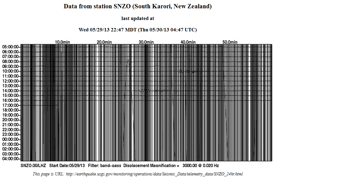
Technical Fault? or Mag 9.0 Karori, NZ
there was a similar graph at approx same time plus one day last year 31.05.201 LISS SNZO
there was a similar graph at approx same time plus one day last year 31.05.201 LISS SNZO
edit on 30-5-2013 by muzzy
because: (no reason given)
reply to post by muzzy
With 27 feet wall wave?
Or just....technical fault.
9.1 to 9.9 offshore California?
Technical Fault? or Mag 9.0 Karori, NZ
With 27 feet wall wave?
Or just....technical fault.
reply to post by muzzy
Basically at around 19:00 UTC, or 8am in Kapitistan, there was a regular rhythmic disturbance picked up at the seismo which threw it right of it's breakfast. You would not happen to know anything about a regular rhythmic motion in the morning would you Muzzy?
This motion lasted for around 40 minutes, however the signal continued in a different form - looks like laboured breathing maybe - past midnight UTC, or 1pm in Kapitistan. The seismo displays have not recovered yet.
With a filter applied - as in the LISS SNZO (Click any of these for a larger image)
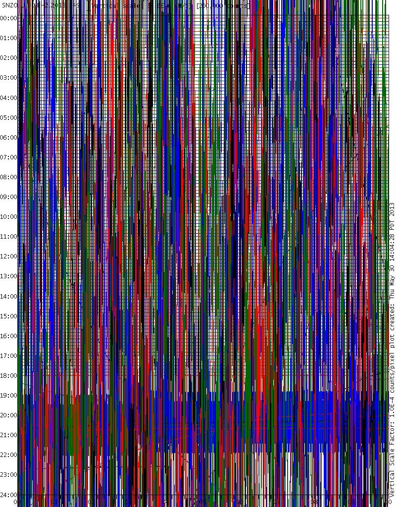
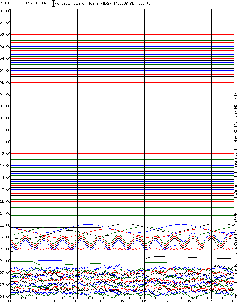
Allowing the program to determine the counts. You can see the regular up and down on about a one minute cycle. ETA To give you an idea of the strength of this and how it is swamping the seismogram note that the counts scale on the filtered one is 200,000. Taking the filter off the count jumps to 45,098,867 - the more counts the more powerful the signal. What ever caused the signal it is 225 times stronger than a normal signal.
And then today
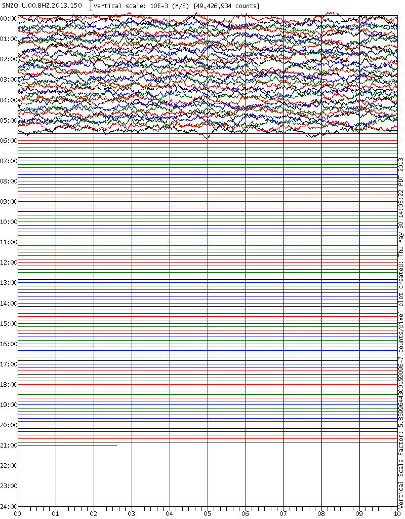
When the LISS display gets to 05:40 UTC today as the start point then the display will return to normal.
Since there was the same signal a year ago maybe it is some sort of annual test? BTW last year was leap year was it not. That might explain the day difference.
Basically at around 19:00 UTC, or 8am in Kapitistan, there was a regular rhythmic disturbance picked up at the seismo which threw it right of it's breakfast. You would not happen to know anything about a regular rhythmic motion in the morning would you Muzzy?
This motion lasted for around 40 minutes, however the signal continued in a different form - looks like laboured breathing maybe - past midnight UTC, or 1pm in Kapitistan. The seismo displays have not recovered yet.
With a filter applied - as in the LISS SNZO (Click any of these for a larger image)

Allowing the program to determine the counts. You can see the regular up and down on about a one minute cycle. ETA To give you an idea of the strength of this and how it is swamping the seismogram note that the counts scale on the filtered one is 200,000. Taking the filter off the count jumps to 45,098,867 - the more counts the more powerful the signal. What ever caused the signal it is 225 times stronger than a normal signal.

And then today

When the LISS display gets to 05:40 UTC today as the start point then the display will return to normal.
Since there was the same signal a year ago maybe it is some sort of annual test? BTW last year was leap year was it not. That might explain the day difference.
edit on 30/5/2013 by PuterMan because: (no reason given)
USGS went off the deep end!
Last updated 1969-12-30!
Time showing 7:53:55 UTC!!!
earthquake.usgs.gov...
Ottawa is still perking!
www.ldeo.columbia.edu...
WOQ
Last updated 1969-12-30!
Time showing 7:53:55 UTC!!!
earthquake.usgs.gov...
Ottawa is still perking!
www.ldeo.columbia.edu...
WOQ
Has anyone done any studies to find out which regions are seizmically linked or even IF they are linked in any way?
So for example, if an event happened in Alaska, then whether the earth has a "resonant point" which maybe anywhere but which causes a similar but smaller sympathy quake somewhere else? Dont know what amount of time it would take for these (if they exist) sympathy quakes to occur. It may be a whacky idea but it may just have some basis in fact - who knows what the Earth gets up to?
Opinions anyone?
reply to post by qmantoo
Interesting timing for your question, since I read a paper out of the University of Alaska this morning by Tape et al. discussing dynamic triggering of an earthquake. In this case, the Love waves from the 11 April 2012 Mw 8.6 Sumatra quake are shown to have initiated nucleation (which ramped up exponentially for 24s) before triggering the Mw 3.9 Nenana, Alaska EQ.
[The wavelength of these surface waves was 580 km--that is one long wave! Amplitudes in Alaska were 4 centimeters]
I don't think there are any areas that are "linked", such as southern California and Turkey, for example. It has more to do with the waves from one earthquake hitting a distant fault at the proper angle, and the 2nd fault probably needs to be near it's critical failure point.
At least that is how I understand it.
.....................................
I found this USGS site today and wanted to share. It is similar to RSOE, minus many of alerts such as flu outbreaks, etc.
Natural Hazards Support System
It shows earthquakes, floods, wildfires, tornadoes, NEXRAD radar to track storm systems, etc. I really like the information when you click on any of the symbols on the map--it will take you to individual flood gages, the National Interagency Fire Center, etc. Check it out.
edit on 5/30/2013 by Olivine because: (no reason given)
reply to post by PuterMan
Wasn't me
Yeah because it was at the same time as last year (taking the leap year into account) it must be a test or a re-calibration.
Still has lines right now, will check again after 6:00pm NZST and see if you are right
EDIT: yup you were spot on, now 5:40pm, vertical lines are gone
earthquake.usgs.gov...
edit on 31-5-2013 by muzzy because: (no reason
given)
reply to post by Olivine
Hmmm.....good old USGS.
It won't let me save it!
Says, access denied!
'Useless' must have put me on a _ _ _ _ list!!!
WOQ
Hmmm.....good old USGS.
It won't let me save it!
Says, access denied!
'Useless' must have put me on a _ _ _ _ list!!!
WOQ
reply to post by muzzy
I've put LDEO back on, although I overwrote the original page with that NEIC stuff, I still had the kmz files so was just a matter of writing the mps back in order.
The address is still different though, LDEO-3, as Wordpress won't replace the original.
Looks the same though.
eqarchives.wordpress.com...
up to date as well.
Dumped the NEIC, you can get that through USGS, and probably get more events there too.
I recall some critsizm last year when I did USGS on my blog, some said why rehash waht is already done by them.
Ha!, now that they have totally trashed their own site with stuff people don't want, there might be a call for a "mirror" that goes back more than 30 days???
Thanks for the 10 views anyway
edit on 31-5-2013 by muzzy because: (no reason given)
Originally posted by Olivine
I don't think there are any areas that are "linked", such as southern California and Turkey, for example. It has more to do with the waves from one earthquake hitting a distant fault at the proper angle, and the 2nd fault probably needs to be near it's critical failure point.
I am sure that the Earth is probably similar to the Moon in that an impact at one point would reverberate around like pebbles in a pond. NASA said that they could hear the Moon reverberating like a bell/gong when they smashed one of the rocket boosters into the Moon a while ago.
If it could be shown that some eqs in one region precede/follow others in another - by a significant above-probablity chance, then there may be a correllation beyond just simple Love waves perhaps. Of course, it would not be popular theory because it could not be explained. Waves and wave theory is something which we are all currently comfortable with and accept as science. If the Earth had resonant points, then what then?
What are the chances of earthquakes in one region following those from another I wonder? For example, in my play database there are over 300 eqs for Oklahoma in the last few years and it would be interesting to see if, for each one, there were the same follow-on regions triggered within a given time window (36 hours?).
reply to post by qmantoo
Seismic waves do reverberate/bounce around the earth; for days after the largest quakes. It sounds like you have laid out your next project, qmantoo.
This is an odd location--in the middle of the Pacific plate with no obvious fault lines more hundreds of kms.
Location in Google Maps
Derived from Event Data Source: USGS
Powered by QVSData
..............................
I just read, and have to add these two links from Erik Klemetti's Eruptions Blog:
Post from May 29th: Looking for Patterns in Earthquake Data
Follow-up posted on the 30th: Earthquakes, Patterns and Predictions
Most excellent analysis...
Seismic waves do reverberate/bounce around the earth; for days after the largest quakes. It sounds like you have laid out your next project, qmantoo.
This is an odd location--in the middle of the Pacific plate with no obvious fault lines more hundreds of kms.
Magnitude 5.3 - South Pacific Ocean
Location in Google Maps
- Date-Time: Friday, May 31, 2013 @ 11:11:09 UTC
- Earthquake location: 6.474°S, 122.120°W,
- Earthquake depth: 10.0 km
- Distances:
1899km (1179mi) E of Atuona, French Polynesia
3214km (1997mi) ENE of Mahina, French Polynesia
3219km (2000mi) ENE of Pirae, French Polynesia
3223km (2002mi) ENE of Papeete, French Polynesia
3227km (2005mi) ENE of Faaa, French Polynesia
- Event ID: usb000haaz
Derived from Event Data Source: USGS
Powered by QVSData
..............................
I just read, and have to add these two links from Erik Klemetti's Eruptions Blog:
Post from May 29th: Looking for Patterns in Earthquake Data
Follow-up posted on the 30th: Earthquakes, Patterns and Predictions
Most excellent analysis...
edit on 5/31/2013 by Olivine because: addition
Today I have been working on it and there appears to be some very interesting things coming out at the end. I really dont know if I have done this
correctly and there is no easy way to cross-check what I have found. Here is the 'spec' or the idea I have been working towards and now I just have
to find a way to display the results in some kind of a graph or diagram.
==============================
Exploring the hypothesis that the earth has "resonant points" distant from the initial event.
This could apply to anything, but since earthquake data is readily available, I am applying it to that.
So for example, if an event happened in Alaska, then investigate whether the earth has a "resonant point" which maybe anywhere but which causes a similar possibly smaller sympathy quake somewhere else? Dont know what amount of time it would take for these (if they exist) sympathy quakes to occur. Would have to try different time windows and see if there is a correllation pattern.
At the moment I have taken all the individual events for Arkansas (as an example region) and then mapped the time offset and region of subsequent eq events within a 36 hour time window. In my database there are 1639 Arkansas eq events. Taking each of these events one at a time (n), I compare the next record (n+1) time of eq with the Arkansas one. Write a record of the time difference and the region of record n+1. Then I do n+2, etc until I hit the 36 hour mark. Then I get the next Arkansas eq event and do the same thing with that.
I end up with a huge number of records all describing a region and a time offset to an Arkansas event record.
Then I go through these records and sort them into time slices. So I count how many are between 0 and 42 minutes of an Arkansas eq event for each region, then I count how many of each region are within 43 and 85 minutes of the Arkansas event and so on up until 36 hours. I end up with a set of records for each region split up into slices of time, how many occurred in that region within each of the time slices, 0-42 minutes from the original Arkansas event, 43-85 minutes, etc etc.
Out of 415500 records written the analysis looks like this. I have only shown the first two time slices. I have not limited the magnitude, so whatever is reported by USGS.
Between 0 minutes and 42 minutes after an earthquake in Arkansas ...
There were 1168 occurrances in Southern California
There were 964 occurrances in Northern California
There were 877 occurrances in Central Alaska
There were 850 occurrances in Southern Alaska
There were 668 occurrances in Central California
There were 390 occurrances in Baja California, Mexico
There were 314 occurrances in Fox Islands, Aleutian Islands, Alaska
There were 291 occurrances in Andreanof Islands, Aleutian Islands, Alaska
There were 279 occurrances in Nevada
There were 164 occurrances in western Montana
There were 158 occurrances in Island of Hawaii, Hawaii
There were 158 occurrances in Kenai Peninsula, Alaska
There were 146 occurrances in Alaska Peninsula
There were 143 occurrances in Utah
There were 137 occurrances in Greater Los Angeles area, California
There were 128 occurrances in Puerto Rico region
There were 107 occurrances in near the east coast of Honshu, Japan
There were 99 occurrances in off the east coast of Honshu, Japan
There were 95 occurrances in San Francisco Bay area, California
There were 93 occurrances in northern Alaska
There were 92 occurrances in Kodiak Island region, Alaska
There were 59 occurrances in Washington
There were 53 occurrances in Virgin Islands region
Between 43 minutes and 85 minutes after an earthquake in Arkansas
There were 1078 occurrances in Southern California
There were 941 occurrances in Northern California
There were 813 occurrances in Southern Alaska
There were 808 occurrances in Central Alaska
There were 619 occurrances in Central California
There were 400 occurrances in Baja California, Mexico
There were 375 occurrances in Fox Islands, Aleutian Islands, Alaska
There were 310 occurrances in Andreanof Islands, Aleutian Islands, Alaska
There were 228 occurrances in Nevada
There were 174 occurrances in Kenai Peninsula, Alaska
There were 164 occurrances in Utah
There were 153 occurrances in Alaska Peninsula
There were 149 occurrances in Island of Hawaii, Hawaii
There were 127 occurrances in Greater Los Angeles area, California
There were 120 occurrances in near the east coast of Honshu, Japan
There were 105 occurrances in western Montana
There were 103 occurrances in San Francisco Bay area, California
There were 92 occurrances in northern Alaska
There were 90 occurrances in Puerto Rico region
There were 82 occurrances in off the east coast of Honshu, Japan
There were 71 occurrances in Kodiak Island region, Alaska
There were 65 occurrances in Washington
There were 64 occurrances in Unimak Island region, Alaska
There were 58 occurrances in Virgin Islands region
I stop displaying results when the occurrances get below 50 for a region
Running it for the eq region you posted just now we get an almost 'normal' output of:
(probably cannot say any significant resonances)
There are 496 items in cor_regions table
Between 0 minutes and 42 minutes after an earthquake in South Pacific Ocean ...
There were 7 occurrances in Southern California
There were 5 occurrances in Southern Alaska
There were 2 occurrances in western Montana
There were 1 occurrances in Central Alaska
There were 1 occurrances in Northern California
There were 1 occurrances in Nevada
There were 1 occurrances in Central California
There were 1 occurrances in Tonga
Between 43 minutes and 85 minutes after an earthquake in South Pacific Ocean
There were 1 occurrances in south of Panama
There were 1 occurrances in Northern California
There were 1 occurrances in Salta, Argentina
There were 1 occurrances in Vanuatu region
There were 1 occurrances in Baja California, Mexico
There were 1 occurrances in Mona Passage, Dominican Republic
There were 1 occurrances in Antofagasta, Chile
There were 1 occurrances in Island of Hawaii, Hawaii
Between 86 minutes and 128 minutes after an earthquake in South Pacific Ocean
There were 2 occurrances in Central Alaska
There were 2 occurrances in Southern California
There were 2 occurrances in Southern Alaska
There were 2 occurrances in Dominican Republic region
There were 1 occurrances in Kenai Peninsula, Alaska
...
reply to post by qmantoo
I am VERY confused!
Where exactly does the figure 496 come from? As far as I can see since the 5.3 there have been 19 events recorded by USGS at the time of writing. I know they do miss a few, but not that many!
I am VERY confused!
Where exactly does the figure 496 come from? As far as I can see since the 5.3 there have been 19 events recorded by USGS at the time of writing. I know they do miss a few, but not that many!
5 in Bermuda?
RSOE EDIS
EDIS Number: EQ-20130531-330129-BMU
Magnitude: 5
Mercalli scale: 5
Date-Time [UTC]: Friday, 31th May 2013 at 08:25 PM
Local Date/Time: Saturday, June 01, 2013 at 18:25 in the evening at epicenter
Coordinate: 29° 4.200, 50° 39.600
Depth: 33 km (20.51 miles)
Hypocentrum: Shallow depth
Class: Moderate
Region: Atlantic Ocean - North
Country: Bermuda
Location: 1,390 km (0.62 miles) - of Saint George, Saint George, Bermuda
Source: EMSC
Generated Tsunami: Not or no data
Damage: Not or no data
RSOE EDIS
EDIS Number: EQ-20130531-330129-BMU
Magnitude: 5
Mercalli scale: 5
Date-Time [UTC]: Friday, 31th May 2013 at 08:25 PM
Local Date/Time: Saturday, June 01, 2013 at 18:25 in the evening at epicenter
Coordinate: 29° 4.200, 50° 39.600 Depth: 33 km (20.51 miles)
Hypocentrum: Shallow depth
How the heck did they get this when no one else has it?
I checked USGS and every other source, no one has it does anyone else have it listed anywhere other than RSOE EDIS?
I wonder, could meteors cause all these errors, what kind of signature did the Russian meteor leave?
new topics
-
Cats Used as Live Bait to Train Ferocious Pitbulls in Illegal NYC Dogfighting
Social Issues and Civil Unrest: 15 minutes ago -
The Good News According to Jesus - Episode 1
Religion, Faith, And Theology: 2 hours ago -
HORRIBLE !! Russian Soldier Drinking Own Urine To Survive In Battle
World War Three: 4 hours ago -
Bobiverse
Fantasy & Science Fiction: 7 hours ago -
Florida man's trip overseas ends in shock over $143,000 T-Mobile phone bill
Social Issues and Civil Unrest: 7 hours ago -
Former Labour minister Frank Field dies aged 81
People: 9 hours ago -
SETI chief says US has no evidence for alien technology. 'And we never have'
Aliens and UFOs: 11 hours ago
top topics
-
President BIDEN Vows to Make Americans Pay More Federal Taxes in 2025 - Political Suicide.
2024 Elections: 16 hours ago, 19 flags -
Florida man's trip overseas ends in shock over $143,000 T-Mobile phone bill
Social Issues and Civil Unrest: 7 hours ago, 8 flags -
SETI chief says US has no evidence for alien technology. 'And we never have'
Aliens and UFOs: 11 hours ago, 7 flags -
Former Labour minister Frank Field dies aged 81
People: 9 hours ago, 4 flags -
Bobiverse
Fantasy & Science Fiction: 7 hours ago, 3 flags -
Ode to Artemis
General Chit Chat: 16 hours ago, 3 flags -
This is our Story
General Entertainment: 13 hours ago, 3 flags -
Cats Used as Live Bait to Train Ferocious Pitbulls in Illegal NYC Dogfighting
Social Issues and Civil Unrest: 15 minutes ago, 2 flags -
HORRIBLE !! Russian Soldier Drinking Own Urine To Survive In Battle
World War Three: 4 hours ago, 1 flags -
The Good News According to Jesus - Episode 1
Religion, Faith, And Theology: 2 hours ago, 0 flags
active topics
-
President BIDEN Vows to Make Americans Pay More Federal Taxes in 2025 - Political Suicide.
2024 Elections • 87 • : FlyersFan -
Thousands Of Young Ukrainian Men Trying To Flee The Country To Avoid Conscription And The War
Other Current Events • 134 • : Consvoli -
Cats Used as Live Bait to Train Ferocious Pitbulls in Illegal NYC Dogfighting
Social Issues and Civil Unrest • 1 • : chiefsmom -
I Guess Cloud Seeding Works
Fragile Earth • 40 • : BrucellaOrchitis -
"We're All Hamas" Heard at Columbia University Protests
Social Issues and Civil Unrest • 277 • : Xtrozero -
The Good News According to Jesus - Episode 1
Religion, Faith, And Theology • 2 • : Springbok -
Bobiverse
Fantasy & Science Fiction • 2 • : Springbok -
HORRIBLE !! Russian Soldier Drinking Own Urine To Survive In Battle
World War Three • 18 • : watchitburn -
Florida man's trip overseas ends in shock over $143,000 T-Mobile phone bill
Social Issues and Civil Unrest • 13 • : Consvoli -
British TV Presenter Refuses To Use Guest's Preferred Pronouns
Education and Media • 137 • : Annee