It looks like you're using an Ad Blocker.
Please white-list or disable AboveTopSecret.com in your ad-blocking tool.
Thank you.
Some features of ATS will be disabled while you continue to use an ad-blocker.

Quake Watch 2013
page: 88share:
reply to post by PuterMan
Has any one ever told you that you are quite the FUNNY GUY??? Is it from being brought up on a diet of Harry Seacombe, Monty Python, Benny Hill and Billy Connelly etc?
Hope you're planning on getting me something nice for my 2nd birthday!
Has any one ever told you that you are quite the FUNNY GUY??? Is it from being brought up on a diet of Harry Seacombe, Monty Python, Benny Hill and Billy Connelly etc?
Hope you're planning on getting me something nice for my 2nd birthday!
www.ldeo.columbia.edu/~ekstrom/Research/SWD/current/RADB_SWD_grd.html
16 UTC
17 UTC
geofon.gfz-potsdam.de/eqinfo/event.php?id=gfz2013jvax
16 UTC
2013 5 20 14 8 0.0 41.25 -127.75 33.0 5.0 OFF COAST OF NORTHERN CALIFORNIA
2013 5 20 13 12 48.0 41.50 -127.50 33.0 5.1 OFF COAST OF NORTHERN CALIFORNIA
17 UTC
2013 5 20 14 8 0.0 41.25 -127.25 33.0 4.9 OFF COAST OF NORTHERN CALIFORNIA
2013 5 20 13 12 48.0 42.25 -127.75 33.0 5.1 OFF COAST OF OREGON

geofon.gfz-potsdam.de/eqinfo/event.php?id=gfz2013jvax
2013 5 19 8 21 36.0 -15.75 -13.25 33.0 5.0 SOUTHERN MID-ATLANTIC RIDGE
2013 5 19 8 14 24.0 -15.75 -13.25 33.0 4.9 SOUTHERN MID-ATLANTIC RIDGE


2013 5 19 1 11 20.0 -27.25 -12.75 33.0 4.8 SOUTHERN MID-ATLANTIC RIDGE
2013 5 18 23 25 4.0 -60.50 -33.50 33.0 5.2 SCOTIA SEA


2013 5 19 2 52 0.0 -9.50 154.50 33.0 4.8 D'ENTRECASTEAUX ISLANDS REGION


edit on 20-5-2013 by wujotvowujotvowujotvo
because: (no reason given)
reply to post by wujotvowujotvowujotvo
Odd, that one off California isn't on USGS yet o.O It's definitely on EMSC's list, though:
www.emsc-csem.org...
It's got to be errors in the new USGS map, because I'm only seeing 73 quakes, and they're apparently random ones. Driving me crazy today.
Odd, that one off California isn't on USGS yet o.O It's definitely on EMSC's list, though:
Magnitude M 4.1
Region OFF COAST OF NORTHERN CALIFORNIA
Date time 2013-05-20 14:07:57.2 UTC
Location 41.43 N ; 127.50 W
Depth 10 km
Distances 3626 km NW of Mexico City, Mexico / pop: 12,294,193 / local time: 09:07:57.2 2013-05-20
532 km SW of Salem, United States / pop: 154,637 / local time: 07:07:57.2 2013-05-20
277 km W of Crescent City, United States / pop: 7,643 / local time: 07:07:57.2 2013-05-20
www.emsc-csem.org...
It's got to be errors in the new USGS map, because I'm only seeing 73 quakes, and they're apparently random ones. Driving me crazy today.
reply to post by Nyiah
LDEO puts these quakes 100's of kms offshore. When I looked at the seismos, and especially the spectrograms, from the area, it looks like possibly 5 different events. Maybe these are volcanic eruptions at the spreading ridge?
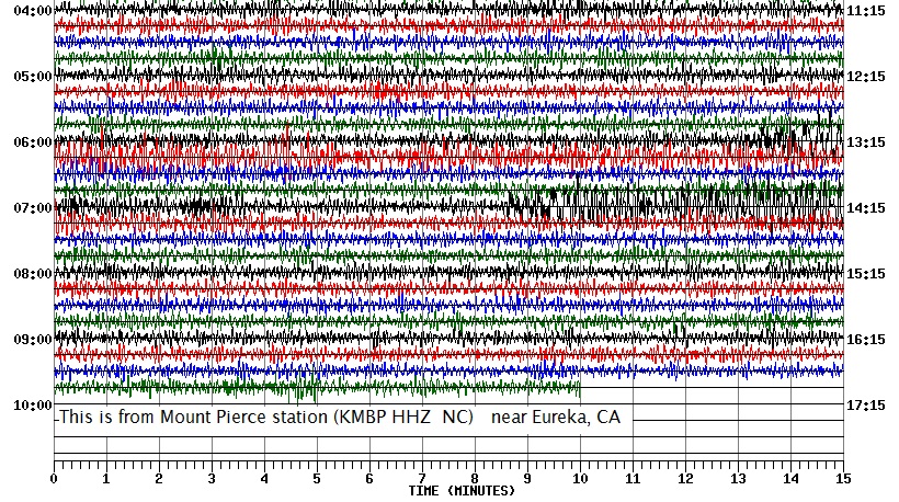
First, the seismogram from the Mount Pierce station, south of Fortuna, CA. Notice how long the shaking lasts after the 14:08:00UTC quake; six minutes?:
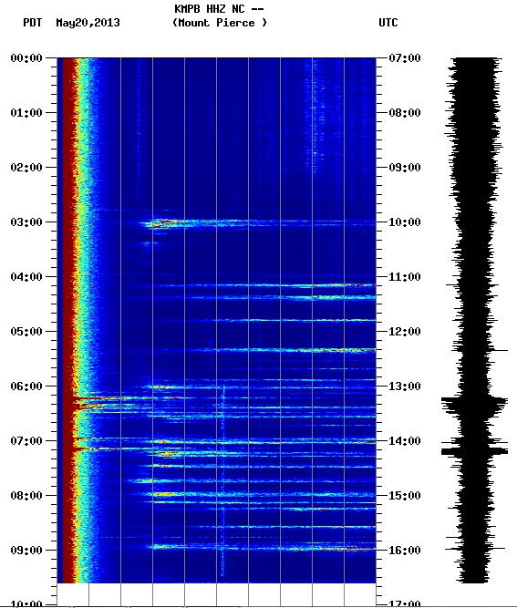
Next is the spectrogram from the same station. It sure looks like more than 2 earthquakes.
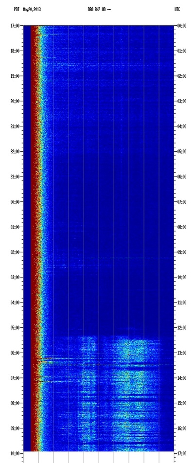
And here is the spectro from Dobson Butte, in central Oregon, at least 400 km away from the LDEO coordinates, just for comparision:

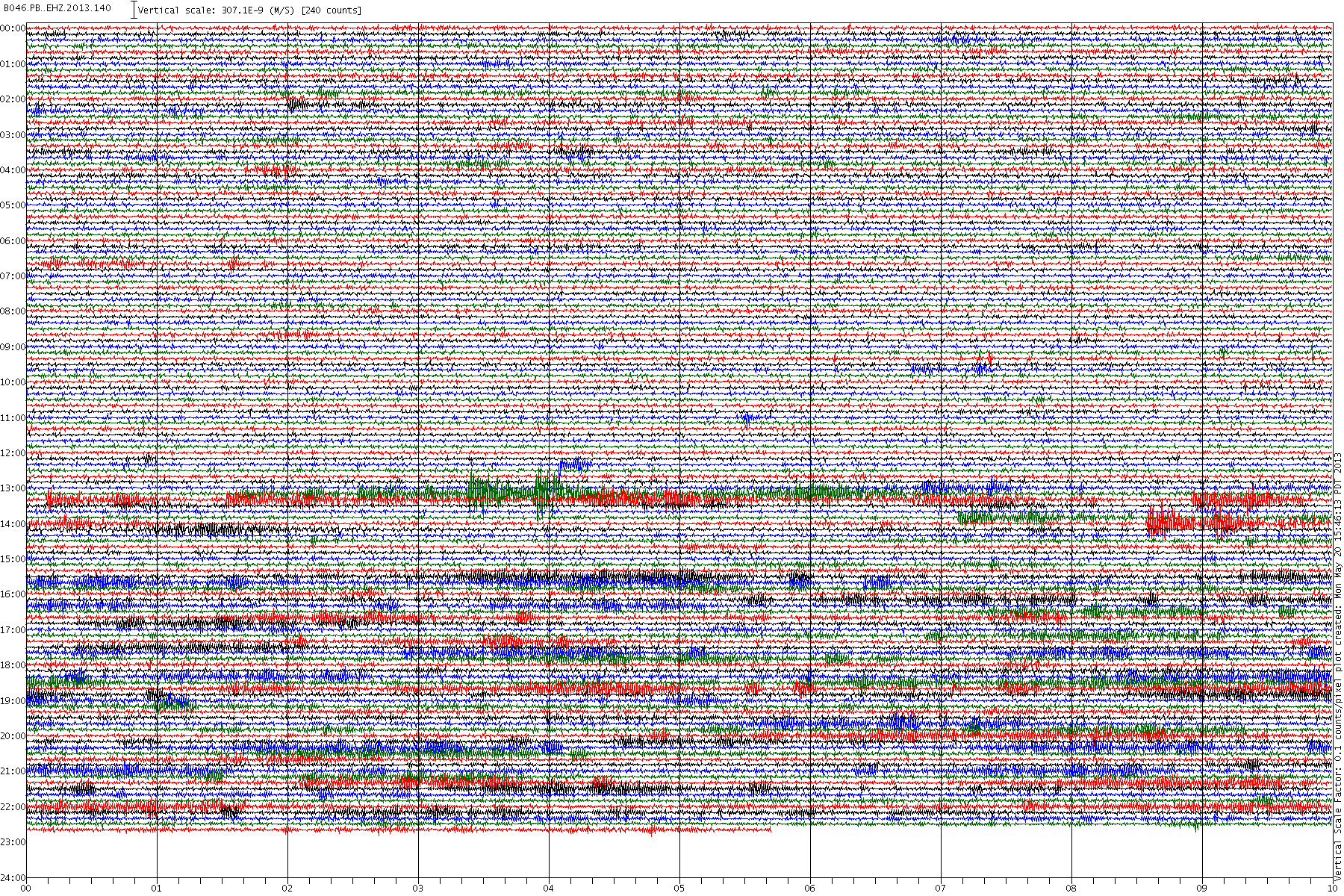
The seismo from the nearest borehole instrument PB046 isn't very impressive, but it looks like whatever is shaking is still going.
Shall we take bets on how long it takes for NEIC to post these to USGS? Odds of number of revisions?
LDEO puts these quakes 100's of kms offshore. When I looked at the seismos, and especially the spectrograms, from the area, it looks like possibly 5 different events. Maybe these are volcanic eruptions at the spreading ridge?
First, the seismogram from the Mount Pierce station, south of Fortuna, CA. Notice how long the shaking lasts after the 14:08:00UTC quake; six minutes?:
Next is the spectrogram from the same station. It sure looks like more than 2 earthquakes.
And here is the spectro from Dobson Butte, in central Oregon, at least 400 km away from the LDEO coordinates, just for comparision:
The seismo from the nearest borehole instrument PB046 isn't very impressive, but it looks like whatever is shaking is still going.
Shall we take bets on how long it takes for NEIC to post these to USGS? Odds of number of revisions?
edit on 5/20/2013 by Olivine because:
add a thought
edit on 5/20/2013 by Olivine because: (no reason given)
Originally posted by SpaceJockey1
reply to post by PuterMan
Has any one ever told you that you are quite the FUNNY GUY??? Is it from being brought up on a diet of Harry Seacombe, Monty Python, Benny Hill and Billy Connelly etc?
Hope you're planning on getting me something nice for my 2nd birthday!
Now those were comics. Not that keen on Benny Hill. Nothing like them these days.
Sorry, no pressies for being in ATS 2 years. I did not get one either.
So, the predictions seem to have got a bit thin. You got a hit with your last one as I recall. Care to hazard a guess for the next Mag 7?
reply to post by Olivine
I also had a look at B046. Not a lot really but I think much of that is Russia.
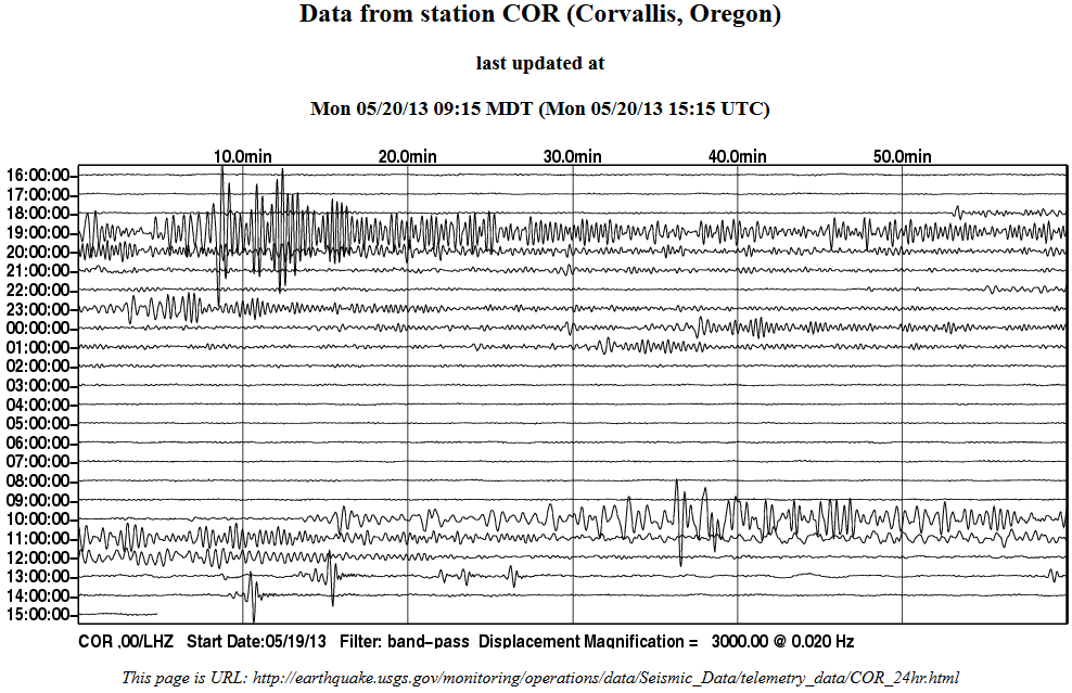
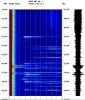
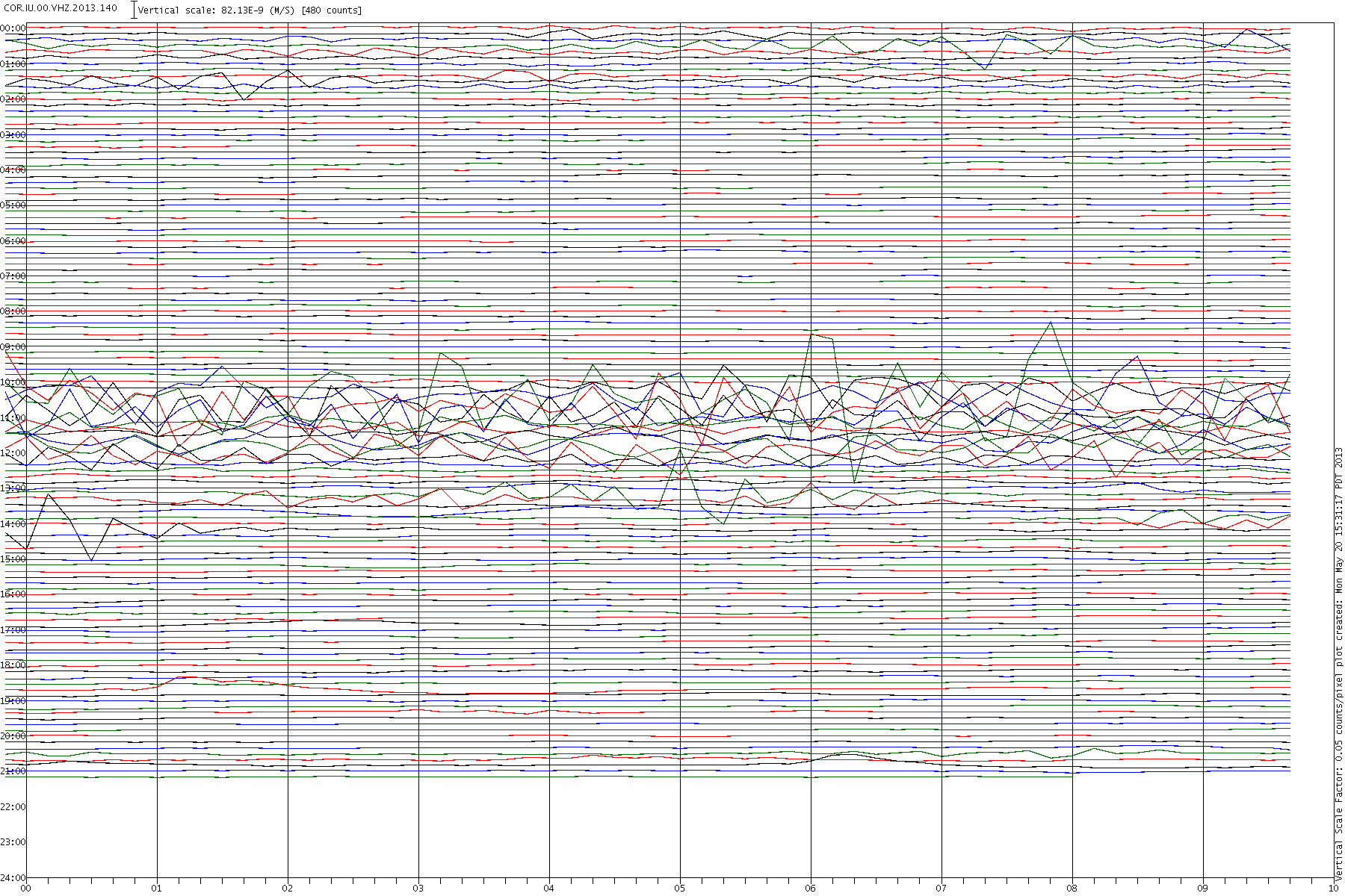
Take a look first at the EMSC data. The FIRST station mentioned is COR. Odd that. It is further away than the B046/7 etc
VHZ channels are very good for showing teleseisms and in this context 400 km constitutes a teleseism. Here is the closest VHZ channel I could find quickly. ALL of that is Kamchatka, except one event. Look how the 14:07 is bracketed by Kamchatskiy
Here is COR and you can see a very small wobble at 14:09** matching the EMSC data. There is another almost overlaying it, but that is I think the 13:57 from Kamchatskiy pulling into the station. ETA: Just checked that. Yes 5400 km ~11 minutes. Fits.
**Estimate as I forgot to mention that VHZ seismograms are incorrectly registered, something that IRIS is aware of but probably will not get changed before new software comes out for these seismograms.
Click for the humungous picture
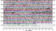
So, here is B046. Without the travel calculator it is difficult to be 100% accurate but COR is ~490 km from the event and B046 is ~297 - so about 200 km closer. At ~8km/second that puts the red stronger trace on B046 at about the right time to be that event. All the rest is Kamchatsky or is it? Could be local to the California area but it is definitely small and/or distant. On the only accelerometer that shows anything none of this registers.
Click for the humungous picture
I rest my case M'Lady. One single event probably! The rest maybe undersea volcanoes or something like that I grant you.
I also had a look at B046. Not a lot really but I think much of that is Russia.
Take a look first at the EMSC data. The FIRST station mentioned is COR. Odd that. It is further away than the B046/7 etc
VHZ channels are very good for showing teleseisms and in this context 400 km constitutes a teleseism. Here is the closest VHZ channel I could find quickly. ALL of that is Kamchatka, except one event. Look how the 14:07 is bracketed by Kamchatskiy
Prov,Date/Time UTC,Latitude,Longitude,Magnitude,Depth(Km),Location
emsc,2013-05-20 16:54:29, -10.026, 111.580, 4.1, 10.0, South Of Java Ind.
emsc,2013-05-20 14:55:48, 0.534, 123.898, 5.0, 215.0, Minahasa Sulawesi Ind.
emsc,2013-05-20 14:27:33, 52.374, 160.061, 4.3, 60.0, Off E. Coast Of Kamchatka
emsc,2013-05-20 14:12:46, 52.346, 160.117, 5.0, 60.0, Off E. Coast Of Kamchatka
emsc,2013-05-20 14:07:57, 41.422, -127.508, 4.1, 10.0, Off Coast Of Northern California
emsc,2013-05-20 13:57:07, 52.417, 159.572, 4.8, 60.0, Off E. Coast Of Kamchatka
emsc,2013-05-20 12:44:19, 57.204, 154.013, 4.3, 33.0, Sea Of Okhotsk
emsc,2013-05-20 12:43:34, 52.111, 160.386, 4.8, 40.0, Off E. Coast Of Kamchatka
emsc,2013-05-20 10:54:23, 52.403, 159.963, 4.8, 39.0, Off E. Coast Of Kamchatka
emsc,2013-05-20 09:49:04, -44.915, -80.594, 6.5, 10.0, Off Coast Of Aisen Chile
Here is COR and you can see a very small wobble at 14:09** matching the EMSC data. There is another almost overlaying it, but that is I think the 13:57 from Kamchatskiy pulling into the station. ETA: Just checked that. Yes 5400 km ~11 minutes. Fits.
**Estimate as I forgot to mention that VHZ seismograms are incorrectly registered, something that IRIS is aware of but probably will not get changed before new software comes out for these seismograms.
Click for the humungous picture

So, here is B046. Without the travel calculator it is difficult to be 100% accurate but COR is ~490 km from the event and B046 is ~297 - so about 200 km closer. At ~8km/second that puts the red stronger trace on B046 at about the right time to be that event. All the rest is Kamchatsky or is it? Could be local to the California area but it is definitely small and/or distant. On the only accelerometer that shows anything none of this registers.
Click for the humungous picture

I rest my case M'Lady. One single event probably! The rest maybe undersea volcanoes or something like that I grant you.
edit on 20/5/2013 by PuterMan because: (no reason given)
Kamchatka's still shakin', with a fresh 6.0:
earthquake.usgs.gov...
It sure makes me wonder what's going on down there in the depths of the subduction zone. I wonder if a chunk of the plate down there is breaking apart, assuming it's not hung up on something.
6.0 136km ESE of Petropavlovsk-Kamchatskiy, Russia 2013-05-20 21:55:08-04:00 33.9 km deep
4.6 22km ESE of Petropavlovsk-Kamchatskiy, Russia 2013-05-20 20:01:16-04:00 93.7 km deep
5.3 126km ESE of Petropavlovsk-Kamchatskiy, Russia 2013-05-20 19:01:25-04:00 17.4 km deep
4.8 121km SE of Petropavlovsk-Kamchatskiy, Russia 2013-05-20 18:51:47-04:00 43.8 km deep
4.6 122km ESE of Petropavlovsk-Kamchatskiy, Russia 2013-05-20 18:36:27-04:00 40.0 km deep
5.0 138km SE of Petropavlovsk-Kamchatskiy, Russia 2013-05-20 16:13:54-04:00 32.2 km deep
4.7 145km ESE of Petropavlovsk-Kamchatskiy, Russia 2013-05-20 14:08:48-04:00 40.1 km deep
4.3 65km SE of Vilyuchinsk, Russia 2013-05-20 10:27:39-04:00 83.6 km deep
4.8 147km ESE of Petropavlovsk-Kamchatskiy, Russia 2013-05-20 10:12:43-04:00 45.0 km deep
4.7 129km SE of Petropavlovsk-Kamchatskiy, Russia 2013-05-20 09:57:04-04:00 52.8 km deep
4.7 148km SE of Petropavlovsk-Kamchatskiy, Russia 2013-05-20 08:43:33-04:00 30.5 km deep
4.7 110km ESE of Petropavlovsk-Kamchatskiy, Russia 2013-05-20 06:54:24-04:00 43.8 km deep
4.7 135km SE of Petropavlovsk-Kamchatskiy, Russia 2013-05-19 23:42:39-04:00 49.0 km deep
4.6 201km SE of Petropavlovsk-Kamchatskiy, Russia 2013-05-19 23:38:50-04:00 15.1 km deep
earthquake.usgs.gov...
It sure makes me wonder what's going on down there in the depths of the subduction zone. I wonder if a chunk of the plate down there is breaking apart, assuming it's not hung up on something.
I've had my eyes on Kamchatka since this began. Really getting a Santa Cruz vibe here.
Depths vary right to the SZ, hoping no quakes appear on the other side but who knows...
Depths vary right to the SZ, hoping no quakes appear on the other side but who knows...
Damn.
What is going on with Kamchatka??
I know were all watching the same thing, so I won't torment myself with trying to post a link. Im too nervous about this storm system coming into my area.
What is going on with Kamchatka??
I know were all watching the same thing, so I won't torment myself with trying to post a link. Im too nervous about this storm system coming into my area.
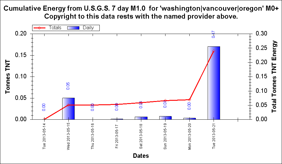
I wanted to know what the TTNT Energy count was for Kamchatka, so ran USGS's data through Excel
72,874.611 TTNT total
thats not much, 57 quakes and all up its only equal to a Mag 6.45
mag4= 33
mag5= 22
mag6= 2
mag7= 0
total= 57
TTNT= 72,874.611
Here is the interactive map of that data, same as USGS, but different colours
I'll be comparing to GFZ which will be more, they had 2 x 6.1's this afternoon, but thought I'd give USGS another chance seeing as they brought the Theoretical P-Wave Travel Times pages back
Hard to tell on todays LISS SNZO from 02:08 on which one is which, without the TT Calculator
earthquake.usgs.gov...
EDIT:
Yep in the same time period GFZ have;
mag4= 25
mag5= 38
mag6= 2
total= 65
TTNT= 134,221.637
ALMOST TWICE THE ENERGY RELEASED
edit on 21-5-2013 by muzzy because: GFZ map after dinner
These have me worried.
Some time ago Puterman and I were discussing the possibility of a springback of the pacific plate.
Now we are seeing action right on the tip of the plate and along that same energetic ridge line in Alaska. The West Coast is frisky as well.
If we start having movement at the top of BC and the bottom of YT in Canada ie, the eastern tip of the plate, I will get very, very concerned.
P
6.0 122km SE of Petropavlovsk-Kamchatskiy, Russia 2013-05-21 00:43:21-05:0036.7 km deep
6.0 122km SE of Petropavlovsk-Kamchatskiy, Russia 2013-05-20 23:59:37-05:0037.1 km deep
5.0 143km ESE of Petropavlovsk-Kamchatskiy, Russia 2013-05-20 23:24:07-05:0028.5 km deep
5.9 109km SE of Petropavlovsk-Kamchatskiy, Russia 2013-05-20 22:08:22-05:0044.1 km deep
5.5 137km ESE of Petropavlovsk-Kamchatskiy, Russia 2013-05-20 22:05:50-05:0014.4 km deep
4.9 138km ESE of Petropavlovsk-Kamchatskiy, Russia 2013-05-20 21:02:45-05:0044.2 km deep
6.0 139km ESE of Petropavlovsk-Kamchatskiy, Russia 2013-05-20 20:55:05-05:0015.1 km deep
USGS
Originally posted by PuterMan
So, the predictions seem to have got a bit thin. You got a hit with your last one as I recall. Care to hazard a guess for the next Mag 7?
Well now that you ask...
My quake radar is anticipating something in the high 7's or more, in the Indonesian (Sumatra) region.
More a 'thrust' type than a strike slip.
Within the next 4 weeks.
reply to post by muzzy
More to the point possibly is the fact that GFZ tend to get it right or closer first time off more often than the others do.
Point in question. GFZ 5.6, EMSC and USGS 6.0. EMSC now down to 5.7
When will USGS come down?
ETA: Just checked the USGS phase data. Average of magnitudes: 5.88 based on 49 counts, so their own data says it is < 6.
By the way you can see the differences between USGS/EMSC/GFZ on my weekly geophysical reports in terms of numbers and the difference between reported and converted magnitudes (mb > Mw)
edit on 21/5/2013 by PuterMan because: (no reason given)
5.6 113km SSW of Ishigaki, Japan 2013-05-21 08:25:5413.3 km deep
Event Time
2013-05-21 08:25:54 UTC
2013-05-21 16:25:54 UTC+08:00 at epicenter
2013-05-21 03:25:54 UTC-05:00 system time
Location
23.418°N 123.686°E depth=13.3km (8.3mi)
USGS
edit on 21-5-2013 by lurksoften because: (no reason
given)
Originally posted by dreamfox1
i see something happening in the cascade zone .
Small, but interesting. Look what else is happening.
Originally posted by PuterMan
So, here is B046. Without the travel calculator it is difficult to be 100% accurate but COR is ~490 km from the event and B046 is ~297 - so about 200 km closer. At ~8km/second that puts the red stronger trace on B046 at about the right time to be that event. All the rest is Kamchatsky or is it? Could be local to the California area but it is definitely small and/or distant. On the only accelerometer that shows anything none of this registers.
Click for the humungous picture
I rest my case M'Lady. One single event probably! The rest maybe undersea volcanoes or something like that I grant you.
I'm stubborn, and going to have to politely disagree.
I think their magnitudes are much too high, but LDEO has it right, in that it was 2 regional events offshore northern CA.
2013 5 20 14 8 0.0 41.75 -127.75 33.0 5.0 OFF COAST OF NORTHERN CALIFORNIA
2013 5 20 13 12 40.0 41.25 -127.75 33.0 5.1 OFF COAST OF NORTHERN CALIFORNIA
This is a screencap of the Cascadia Transportable Array over the past 24 hours. TA link
The top of the pic shows northern WA stations, working south to the bottom showing northern CA stations.
On the left side of the screen, from station J01D (Myrtle Point, OR) down to the south and inland to O03E, shows the 2 offshore events, at 13:12:40 and 14:08:00.
Then toward the right side of the screen, along the entire North to South length of Cascadia; the larger Kamchatka quakes:
01:55:05 mag 6.0,
03:05:50 mag 5.5 & 03:08:22 mag 5.9,
04:59:37 mag 6.0 (this is definitely not a 6.0---maybe 5.6), and
05:43:21 mag 6.0.
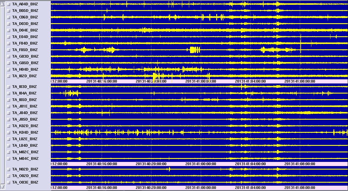
None of the 15 or so mag 4.5 to 5.3 quakes from Russia, that occured during the time shown on the screen cap show up.
edit on 5/21/2013 by
Olivine because: fixing image
edit on 5/21/2013 by Olivine because: forgot my image source link
new topics
-
whistleblower Captain Bill Uhouse on the Kingman UFO recovery
Aliens and UFOs: 3 hours ago -
1980s Arcade
General Chit Chat: 6 hours ago -
Deadpool and Wolverine
Movies: 6 hours ago -
Teenager makes chess history becoming the youngest challenger for the world championship crown
Other Current Events: 7 hours ago -
CIA botched its handling of sexual assault allegations, House intel report says
Breaking Alternative News: 8 hours ago -
Lawsuit Seeks to ‘Ban the Jab’ in Florida
Diseases and Pandemics: 11 hours ago
top topics
-
Lawsuit Seeks to ‘Ban the Jab’ in Florida
Diseases and Pandemics: 11 hours ago, 20 flags -
Starburst galaxy M82 - Webb Vs Hubble
Space Exploration: 13 hours ago, 12 flags -
The Superstition of Full Moons Filling Hospitals Turns Out To Be True!
Medical Issues & Conspiracies: 15 hours ago, 8 flags -
CIA botched its handling of sexual assault allegations, House intel report says
Breaking Alternative News: 8 hours ago, 8 flags -
whistleblower Captain Bill Uhouse on the Kingman UFO recovery
Aliens and UFOs: 3 hours ago, 6 flags -
15 Unhealthiest Sodas On The Market
Health & Wellness: 13 hours ago, 5 flags -
Teenager makes chess history becoming the youngest challenger for the world championship crown
Other Current Events: 7 hours ago, 3 flags -
Deadpool and Wolverine
Movies: 6 hours ago, 3 flags -
1980s Arcade
General Chit Chat: 6 hours ago, 3 flags
active topics
-
15 Unhealthiest Sodas On The Market
Health & Wellness • 31 • : VariedcodeSole -
Fast Moving Disc Shaped UFO Captured on Camera During Flight from Florida to New York City
Aliens and UFOs • 18 • : inflaymes69 -
Definitive 9.11 Pentagon EVIDENCE.
9/11 Conspiracies • 419 • : SchrodingersRat -
They Killed Dr. Who for Good
Rant • 61 • : Cymru -
How ageing is" immune deficiency"
Medical Issues & Conspiracies • 26 • : RookQueen2 -
The Democrats Take Control the House - Look what happened while you were sleeping
US Political Madness • 105 • : SchrodingersRat -
Starburst galaxy M82 - Webb Vs Hubble
Space Exploration • 4 • : SchrodingersRat -
Non-Human Operate Within The Visual Spectrum 'We Cannot See' - ULTRATERRESTRIALS EXIST!
Paranormal Studies • 136 • : burritocat -
New whistleblower Jason Sands speaks on Twitter Spaces last night.
Aliens and UFOs • 39 • : RookQueen2 -
23,000 Dead People Registered Within a Two Week Period In One State
US Political Madness • 39 • : Audreagassulke