It looks like you're using an Ad Blocker.
Please white-list or disable AboveTopSecret.com in your ad-blocking tool.
Thank you.
Some features of ATS will be disabled while you continue to use an ad-blocker.

Quake Watch 2013
page: 86share:
What's going on with Iran lately...
Btw. I hate the new USGS map, I had my settings: 1.5day 5or great magnitude... now I can't set it to 1.5 days, but have to enter a date, which I don't want to do everyday
Btw. I hate the new USGS map, I had my settings: 1.5day 5or great magnitude... now I can't set it to 1.5 days, but have to enter a date, which I don't want to do everyday
Magnitude M 5.8
Region ATACAMA, CHILE
Date time 2013-05-11 15:39:26.3 UTC
local time: 11:39:26.3 2013-05-11
Location 26.11 S ; 69.46 W
Depth 10 km
Distances 822 km N of Santiago, Chile / pop: 4,837,295
164 km NE of Copiapó, Chile / pop: 129,280
65 km NE of Diego de Almagro, Chile / pop: 18,137
Source: EMSC
Source parameters provided by:
GeoForschungsZentrum (GEOFON) -- Potsdam, Germany (GFZ)
20 minutes ago, and USGS still not listing it.!
Will probably go down in size.
Chile's Servicio Sismológico Universidad de Chile have 5.4ML.
Thats another Network that has changed the layout of their web site for the worse, now the individual events don't even have their own pages, so you can't link directly to the details.
edit on 11-5-2013 by muzzy because: add chile link
Alaska, Y U no have shakey-shakey?
I need to dig up the link I had to whoever it is in AK that monitors, I haven't check it in a long while and may not have it anymore. I'm not sure if USGS is correct in no mainland AK quakes for over 24 hours, or if it's just glitchy.
Aha, found it misplaced in a different bookmark folder:
www.aeic.alaska.edu...
So Alaska is just as hoppin' as it usually is, and the new USGS map is simply not showing them. Glitch or intentional? Probably glitch, I'd assume, judging by the tiny ones they're showing for California.
edit on 5/11/2013 by Nyiah because: (no reason given)
further too post by muzzy
5.2Mw now geofon.gfz-potsdam.de...
I kept checking to see it come on LISS NZSO but it never did, too small!
LISS SNZO
5.2Mw now geofon.gfz-potsdam.de...
I kept checking to see it come on LISS NZSO but it never did, too small!
LISS SNZO
edit on 11-5-2013 by muzzy because: new avatar and signature, with icon keys on it
There was a 6.5 at Tonga
Magnitude: 6.5
DateTime: Saturday May 11 2013, 20:46:59 UTC
Region: Tonga
Depth: 215 km
Source: USGS Feed
Magnitude: 6.5
DateTime: Saturday May 11 2013, 20:46:59 UTC
Region: Tonga
Depth: 215 km
Source: USGS Feed
11-05-2013 Manujan-Jask, Iran 6,2 Aftershocks
IISEE data mapped (left image) compared to the UselessSiesmicGoofballS throw the darts at the map attempt.
Not only have they (USGS) messed their own web site up, they couldn't even scale their frikin' maps the same as Google or Yahoo so you can compare at the same scale.
And they seem to be down on the flat, whereas IISEE are all but one 20km to the west in the mountains, where it is more likely to have been.
[color=8BB381](click on upper image (scale at 20/20) for interactive map, opens in new tab/window)
edit on 11-5-2013 by muzzy because:
(no reason given)
I am going to post this here - it was my reply to WOQ about the new UselessSiesmicGoofballS ( another great translation from Muzzy) mobile
Interactive mapping thingy and is relevant to your earthquake viewing.
I use Firefox, and it works OK in that. I get all the options and it is possible to get all three sections up at one time.
It is exactly the same in Chrome, Dragon (a Chrome look alike) and Opera. HOWEVER as you might expect it does NOT work in Internet Explorer 8
You cannot get all three sections up at the same time and it is just generally braindead and useless so it probably goes well with USGS.
If you are using Internet Explorer I suggest you change to Firefox or Chrome or Opera. I prefer FF because I make HEAVY use of the scrapbook (add on - free) for saving pages, but that is just my personal choice.
You may have heard many sites slating IE and believe me there is good reason.
edit on 12/5/2013 by PuterMan because: rats!! well spelling actually!
reply to post by PuterMan
I just want to reinforce Puterman's advice to ditch Internet Explorer.
Having been a Microsoft devotee for well over 10 years, it was hard to stop. But once I took the plunge and downloaded Chrome, I haven't opened IE once, not once.
Since then, not one headache with my browser. Do it now. Download some other browser and use it.
edit on 5/12/2013 by Olivine because:
fixing bad grammar
Potsdam/EMSC have two events on the Galapagos Triple Junction
USGS only has one.
Looks as if something is moving there.
Prov,Date/Time UTC,Latitude,Longitude,Magnitude,Depth(Km),Location
gfzp,2013-05-12 17:49:41, 1.790, -100.480, 4.9, 10.0, Galapagos Triple Junction Region
gfzp,2013-05-08 01:23:41, 1.500, -101.170, 4.4, 10.0, Galapagos Triple Junction Region
USGS only has one.
Looks as if something is moving there.
For future comparisons on LISS.
GFZ released 5 Mw tensor confirming ocean ridge spread. geofon.gfz-potsdam.de/data/alerts/2013/gfz2013jgsf/mt.txt
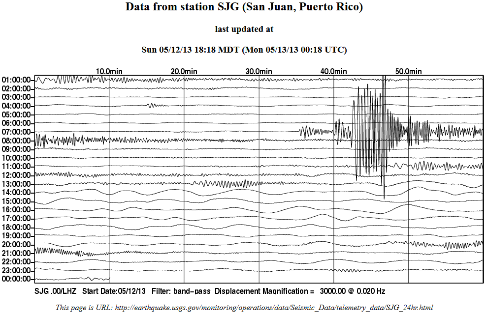
Large traces at 07 from Guatemala subduction with GFZ 5.8 Mw tensor that USGS have a low 5.2
earthquake.usgs.gov/monitoring/operations/data/Seismic_Data/telemetry_data/PAYG_24hr.html
www.ldeo.columbia.edu/~ekstrom/Research/SWD/current/RADB_SWD_grd.html
earthquake.usgs.gov/monitoring/operations/data/Seismic_Data/telemetry_data/ANWB_24hr.html
earthquake.usgs.gov/monitoring/operations/data/Seismic_Data/telemetry_data/BBGH_24hr.html
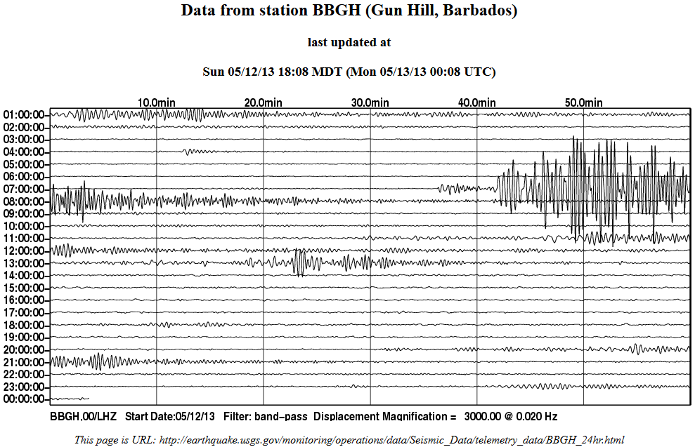
earthquake.usgs.gov/monitoring/operations/data/Seismic_Data/telemetry_data/SJG_24hr.html
GFZ released 5 Mw tensor confirming ocean ridge spread. geofon.gfz-potsdam.de/data/alerts/2013/gfz2013jgsf/mt.txt
Large traces at 07 from Guatemala subduction with GFZ 5.8 Mw tensor that USGS have a low 5.2
earthquake.usgs.gov/monitoring/operations/data/Seismic_Data/telemetry_data/PAYG_24hr.html

www.ldeo.columbia.edu/~ekstrom/Research/SWD/current/RADB_SWD_grd.html
2013 5 12 4 6 8.0 17.75 -46.25 33.0 4.8 NORTHERN MID-ATLANTIC RIDGE
earthquake.usgs.gov/monitoring/operations/data/Seismic_Data/telemetry_data/ANWB_24hr.html

earthquake.usgs.gov/monitoring/operations/data/Seismic_Data/telemetry_data/BBGH_24hr.html

earthquake.usgs.gov/monitoring/operations/data/Seismic_Data/telemetry_data/SJG_24hr.html

Holy cow!!!
I actually heard back from USGS!
Here is the message:
Hello-
I'm sorry that you don't like the new interface, but I encourage you to explore it a bit more since there are new very nice features. Please go to earthquake.usgs.gov... and click on Map in the upper right corner of the page, and then Zoom to... XXX in the top right corner of the map. Also try clicking on the Options link in the top right to explore what is possible in the new interface. The List, Map, and Options links are all toggles to turn on/off the view of these panels in the webpage. Your settings will be automatically saved for your next visit to the webpage.
-Lisa
---------------------------------------------------------------------------------------------
Lisa Wald, Geophysicist
Web Manager
US Geological Survey
[email protected]
Nope...sorry.
The new features don't make up for what they took away
that I used every day! Bah humbug!
Oh well, at least I tried!
Maybe if everyone who misses the features they discontinued
contacts them, they will reconsider? But I doubt it!
Rats!!!
WOQ
reply to post by wasobservingquietly
Well at least you got a reply , so there really are humans there.
I'm still waiting to get a reply from GeonetNZ as to where they have hidden 20 years of Felt Reports that I was using to compile an archive of New Zealand earthquakes with, that disappeared on the 5th September 2012.
EQC (Earthquake Commission) who are in partnership with GNS to provide this taxpayer funded Geonet service are under intense criticism here since the Christchurch quakes of 2010-2011.
Any independent analysis of individual earthquake events using the Felt Intensity Reports is now not possible, because the data has been deleted.
And it is not because funding has been decreased, in fact it has been increased since Chch.
I suppose they have more important stuff to do, like covering their asses in case there is an enquiry.
Also gone are the Peak Ground Velocity and Peak Ground Acceleration reports, which I notice are gone from USGS's pages as well.
I have a lot of Felt Reports archived on my maps, so all is not lost forever, but what I have is inconsistent.
edit on 13-5-2013 by muzzy
because: (no reason given)
With the help of Puterman we can still get the Geonet data, and create a list (not available under the new system at Geonet) of Felt Locations/Counts,
of post Sept 5th 2012 New Zealand Felt Reports.
Here is one last night. Have a look at Geonets page and the Felt Map here, that is the best you get now, but no list.
But we have the technology (thanks to Putermans little programme he created)
That one was quite deep
Here is one last night. Have a look at Geonets page and the Felt Map here, that is the best you get now, but no list.
But we have the technology (thanks to Putermans little programme he created)
Public ID: 2013p357858
Universal Time May 13 2013 at 9:47:29
NZ Standard Time Monday, May 13 2013 at 9:47:29 pm
Latitude, Longitude: 38.34°N, 176.11°E
Location: 25 km south-west of Rotorua
Depth: 212 Km
Magnitude: 4.8
Felt Reports;
Rather Strong 1
Moderate 129
Slight 71
Total 201
Brooklyn, Cannons Creek, Carterton, Clifton, Eastbourne, Hataitai [2], Lower Hutt [2], Mahia Peninsula, Mairangi Bay, Moana, Muritai, Otaihanga, Otaki Beach, Papakowhai, Raureka, Riwaka, Saint Leonards [2], Stoke, Tahunanui, Taneatua, Taradale, Te Karaka, Whitianga, Annesbrook, Ashhurst [3], Awapuni [3], Bay View [2], Bunnythorpe, Camberley, Feilding [2], Foxton Beach [3], Gisborne [5], Greytown, Hastings [2], Havelock North [3], Hihitahi, Hokowhitu [17], Johnsonville, Kapiti, Karori, Kelvin Grove [2], Kimbolton, Levin [11], Marton [5], Masterton, Miramar, Mount Victoria [3], Naenae, Napier [6], Nelson [2], Newlands [2], Newtown, Ngaio [3], Northland, Ohau, Ohiwa, Ohope, Opotiki [8], Otaki [2], Pahiatua [2], Palmerston [2], Papakura, Papatawa, Paraparaumu Beach, Picton [4], Pohangina [2], Porirua, Rata, Ruby Bay, Stokes Valley [2], Takaka, Taupo, Tauweru, Teddington, Te Horo, Te Kaha, Terrace End [4], Thorndon, Upper Hutt [2], Wainuiomata [2], Waiohiki, Waiouru, Waipawa [2], Wairoa [5], Waiwhare, Wellington [4], West End, Whakaki, Whakatane, Whataupoko [5], Whitemans Valley, Woodville [2], Palmerston North [16]
That one was quite deep
edit on 13-5-2013 by muzzy because: (no reason given)
reply to post by muzzy
I almost didn't recognize you!!! But the icons were familiar!
I guess I am lucky to have heard back if you've been waiting since Sept!
It's only frustrating & an inconvenience for me not having the format I liked.
But for you, that would be down right crushing!!!
I wonder why they would have pulled 20 years of felt reports?
It's not like someone could have bumped 'delete'!
I haven't found any place that has everything I want.
They don't all even have the 6.5 near Tonga from yesterday.
I found out about it from my sister!
It just takes all the fun out of watching quakes!
It takes too much time clicking around for what is there!
I told the kids I need Chrome as PuterMan mentioned too.
Don't know when one of them will get time to do it though!
Too bad some of you people on ATS aren't running things!
Then we know it would be done right!!!
WOQ
Another big quake in the Pacific but its deep
Type: Earthquake
Magnitude: 7
DateTime: Tuesday May 14 2013, 00:32:24 UTC
Region: Pagan region, Northern Mariana Islands
Depth: 566.3 km
Source: USGS Feed
gimquakesmap1.com...
earthquake.usgs.gov...
No Watch, Warning, or Advisory
For the continental U.S., Canada, Alaska, Puerto Rico or the Virgin Islands. For other regions please see PTWC
wcatwc.arh.noaa.gov.../2013/05/14/mmriu1/1/WEAK53
edit on 7/30/2012 by dreamfox1 because: (no reason given)
reply to post by dreamfox1
This is not good,no aftershock yet,until this moment.
Another big quake in the Pacific but its deep
reply to post by wasobservingquietly
I'm glad you recognised the icons, its sort of my signature anyway with the maps.
I thought to myself, everyone is having an upgrade, I might as well have one too
I've changed it again just now, its centered on my town with all the earthquakes of 2013 plotted around it.
Like the graffiti sign beside the highway says "nothing to see here, move along please"
I'm not a big fan of our District Council and their policies and have started calling the place Kapitistan.
As I look at USGS 7 day 2.5 + , I see a line of earthquakes from Texas to Tennesee . This is not the first time I have observed a line in that
area.
Is this a fault line or just coincidence ?
Is this a fault line or just coincidence ?
Originally posted by wasobservingquietly
reply to post by muzzy
I guess I am lucky to have heard back if you've been waiting since Sept!
It's only frustrating & an inconvenience for me not having the format I liked.
But for you, that would be down right crushing!!!
I wonder why they would have pulled 20 years of felt reports?
It's not like someone could have bumped 'delete'!
Actually I should have said I sent my query last week, not back in Sept.
I heard back too !
Here is the reply
Good Afternoon Muzzy,
Felt reports are available for all events as described at:
info.geonet.org.nz...
The earthquake ID "2012p564820" can be replaced with an old style number, for example 2839343:
www.geonet.org.nz...
So the same way of using a JSON reader will work for all earthquakes.
Similarly, old earthquake details pages are also constructed by amending the URL appropriately:
www.geonet.org.nz...
Thanks
Sara
Great
So I try that and not only doesn't it work, but it doesn't work for recent events either, like that one I posted 4.8 isn't even listed at all now!.
No Felt Reports anywhere on the Geonet site!
I think they must be loading all the reports back on at this moment
edit on 14-5-2013 by muzzy because: (no reason given)
ETA;
Yeah they must be doing some work on the web site, I just switched back to a page I had left open while I typed the above and now the magnitude has changed from 4.2 to 5.1 reviewed
www.geonet.org.nz...
I'll have to come back to this later.
edit on 14-5-2013 by muzzy because: (no reason given)
I just popped into say USGS is useless now so I'm deleting it from my bookmarks. Maybe if more folks do that, they'll get the hint?
Oh yeah a 5.7, 50 miles deep in southern Peru.
www.emsc-csem.org...
Oh yeah a 5.7, 50 miles deep in southern Peru.
www.emsc-csem.org...
new topics
-
Las Vegas UFO Spotting Teen Traumatized by Demon Creature in Backyard
Aliens and UFOs: 2 hours ago -
2024 Pigeon Forge Rod Run - On the Strip (Video made for you)
Automotive Discussion: 3 hours ago -
Gaza Terrorists Attack US Humanitarian Pier During Construction
Middle East Issues: 3 hours ago -
The functionality of boldening and italics is clunky and no post char limit warning?
ATS Freshman's Forum: 4 hours ago -
Meadows, Giuliani Among 11 Indicted in Arizona in Latest 2020 Election Subversion Case
Mainstream News: 5 hours ago -
Massachusetts Drag Queen Leads Young Kids in Free Palestine Chant
Social Issues and Civil Unrest: 5 hours ago -
Weinstein's conviction overturned
Mainstream News: 7 hours ago -
Supreme Court Oral Arguments 4.25.2024 - Are PRESIDENTS IMMUNE From Later Being Prosecuted.
Above Politics: 8 hours ago -
Krystalnacht on today's most elite Universities?
Social Issues and Civil Unrest: 8 hours ago -
Chris Christie Wishes Death Upon Trump and Ramaswamy
Politicians & People: 9 hours ago
top topics
-
Krystalnacht on today's most elite Universities?
Social Issues and Civil Unrest: 8 hours ago, 9 flags -
Supreme Court Oral Arguments 4.25.2024 - Are PRESIDENTS IMMUNE From Later Being Prosecuted.
Above Politics: 8 hours ago, 8 flags -
Weinstein's conviction overturned
Mainstream News: 7 hours ago, 7 flags -
University of Texas Instantly Shuts Down Anti Israel Protests
Education and Media: 11 hours ago, 6 flags -
Meadows, Giuliani Among 11 Indicted in Arizona in Latest 2020 Election Subversion Case
Mainstream News: 5 hours ago, 5 flags -
Gaza Terrorists Attack US Humanitarian Pier During Construction
Middle East Issues: 3 hours ago, 4 flags -
Massachusetts Drag Queen Leads Young Kids in Free Palestine Chant
Social Issues and Civil Unrest: 5 hours ago, 4 flags -
Las Vegas UFO Spotting Teen Traumatized by Demon Creature in Backyard
Aliens and UFOs: 2 hours ago, 3 flags -
Chris Christie Wishes Death Upon Trump and Ramaswamy
Politicians & People: 9 hours ago, 2 flags -
Any one suspicious of fever promotions events, major investor Goldman Sachs card only.
The Gray Area: 13 hours ago, 2 flags
active topics
-
Meadows, Giuliani Among 11 Indicted in Arizona in Latest 2020 Election Subversion Case
Mainstream News • 10 • : chr0naut -
Supreme Court Oral Arguments 4.25.2024 - Are PRESIDENTS IMMUNE From Later Being Prosecuted.
Above Politics • 75 • : Vermilion -
University student disciplined after saying veganism is wrong and gender fluidity is stupid
Education and Media • 50 • : watchitburn -
VP's Secret Service agent brawls with other agents at Andrews
Mainstream News • 55 • : CarlLaFong -
Cats Used as Live Bait to Train Ferocious Pitbulls in Illegal NYC Dogfighting
Social Issues and Civil Unrest • 23 • : Ravenwatcher -
-@TH3WH17ERABB17- -Q- ---TIME TO SHOW THE WORLD--- -Part- --44--
Dissecting Disinformation • 680 • : 777Vader -
Is there a hole at the North Pole?
ATS Skunk Works • 40 • : Oldcarpy2 -
Fossils in Greece Suggest Human Ancestors Evolved in Europe, Not Africa
Origins and Creationism • 89 • : whereislogic -
University of Texas Instantly Shuts Down Anti Israel Protests
Education and Media • 197 • : NorthOS -
Candidate TRUMP Now Has Crazy Judge JUAN MERCHAN After Him - The Stormy Daniels Hush-Money Case.
Political Conspiracies • 790 • : Oldcarpy2