It looks like you're using an Ad Blocker.
Please white-list or disable AboveTopSecret.com in your ad-blocking tool.
Thank you.
Some features of ATS will be disabled while you continue to use an ad-blocker.

Quake Watch 2013
page: 84share:
reply to post by NiteNGale2
I could understand if perhaps GEE did not get updated to new protocols but the BUD system is central to the whole data collection and display thing.
Yesterday the MDA pages were working. Today they are not. It sounds like a system problem to me, but if they are changing things then surely they would have put some notices to the effect that a change was pending? I am in and out of BUD and MDA pages all day so I would have seen such a notice.
To effect a major change - i.e. changing web addresses would screw up so may systems worldwide unless it was done in a very controlled environment that I just don't believe it can be that, but I could be wrong. Stranger things have happened.

And no mention of any changes on Google search.
I could understand if perhaps GEE did not get updated to new protocols but the BUD system is central to the whole data collection and display thing.
Yesterday the MDA pages were working. Today they are not. It sounds like a system problem to me, but if they are changing things then surely they would have put some notices to the effect that a change was pending? I am in and out of BUD and MDA pages all day so I would have seen such a notice.
To effect a major change - i.e. changing web addresses would screw up so may systems worldwide unless it was done in a very controlled environment that I just don't believe it can be that, but I could be wrong. Stranger things have happened.
And no mention of any changes on Google search.
edit on 6/5/2013 by PuterMan because: (no reason given)
reply to post by muzzy
I'm still here Muzzy, but you are right... has been very quiet lately - round Canterbury anyway!
I'm still here Muzzy, but you are right... has been very quiet lately - round Canterbury anyway!
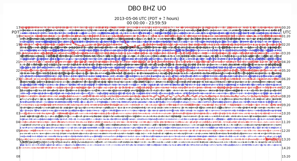
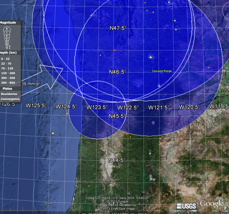
Do the waveforms from this
mag 2.7 Glide, OR at 13:18:37 UTC look strange?
Looking at the event page from PNSN, it hasn't been reviewed, which makes sense because it is under 3.0 and early in the morning.
The waves seem to go on and on for some time; strange for such a small quake. And it can't be the waves from the mag 5.0 in Japan, according to the calculator, they shouldn't show up on the US west coast until 13:25 UTC.
This image is from station UO.DBO.BHZ, only 46 km from the epicenter.
I think this event is going to go through some review; maybe there was a quake offshore at about the same time, that hasn't been listed, that is mucking the seismos?
Here is another look at it from station UW.LON.SHZ (all the way up at Mt. Rainier--from a quick glance at the map, about 380-400 km away).
Am I missing something?
Interesting...the seismos used on the waveform link above have changed. When I 1st posted, DBO was used. In fact every waveform on the page was within 100 km of the given epicenter. Now it shows all the seismos closer to the coast. This was probably offshore, and will be relocated shortly.
Looking at the event page from PNSN, it hasn't been reviewed, which makes sense because it is under 3.0 and early in the morning.
The waves seem to go on and on for some time; strange for such a small quake. And it can't be the waves from the mag 5.0 in Japan, according to the calculator, they shouldn't show up on the US west coast until 13:25 UTC.
This image is from station UO.DBO.BHZ, only 46 km from the epicenter.
I think this event is going to go through some review; maybe there was a quake offshore at about the same time, that hasn't been listed, that is mucking the seismos?
Here is another look at it from station UW.LON.SHZ (all the way up at Mt. Rainier--from a quick glance at the map, about 380-400 km away).
Am I missing something?
edit on 5/6/2013 by Olivine because: add another pic
edit on 5/6/2013 by Olivine because:
formatting
Interesting...the seismos used on the waveform link above have changed. When I 1st posted, DBO was used. In fact every waveform on the page was within 100 km of the given epicenter. Now it shows all the seismos closer to the coast. This was probably offshore, and will be relocated shortly.
edit on 5/6/2013 by Olivine because: updated info
reply to post by Olivine
At 300 to 400km for a small quake I could believe the waveform as the signal would be well attenuated by then. At 46km? Don't think so. Unfortunately I can't get at Vase because of the IRIS problem so I can't load a waveform to have a look.
While I was away looking I was pondering the idea that perhaps the waveform were mixed up?
Mmm.....
Pondering further...the distances of each of the seismos on the link you provided matches the distance in pixels, in terms of ranking, from the DBO event near enough to say that they are all looking at the same event.
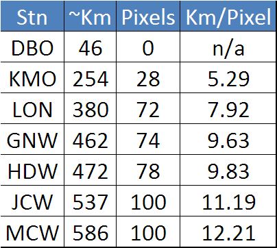
These are only approximate as measuring pixels and measuring km are neither of them accurate.
The question is what about DBO? The signal looks like a teleseism. If we forget about the ranking is it logical that the number of km per pixel should change the further away from the event? My thought is not. I would expect the distance in pixels to change for each seismo but the number of km of travel per pixel to be around the same. (I think if my brain is functioning)
One minute of the seismogram image is ~115 pixels. If you take the difference in pixels and turn that into seconds of separation, and then use an arbitrary 5km per second you get the following distances to the event by comparison to DBO
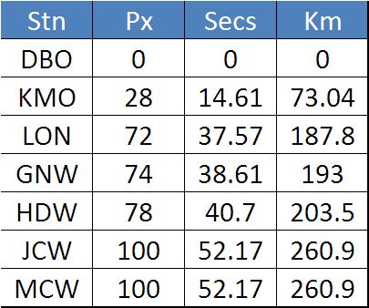
Clearly these are not the same as the distances measured on the map from the event specified, and anyway I query that such an event would make that size of trace so far away.
Given those distances it should be possible to pin point the area of the event very approximately.
Map tools allows you to draw radii and export them to Google Earth.
This puts the DBO trace in the wrong place at the wrong time I think as it should be well after some of the others!!
That may all be rubbish however as it is relative to DBO - I am probably wrong!
At 300 to 400km for a small quake I could believe the waveform as the signal would be well attenuated by then. At 46km? Don't think so. Unfortunately I can't get at Vase because of the IRIS problem so I can't load a waveform to have a look.
While I was away looking I was pondering the idea that perhaps the waveform were mixed up?
Interesting...the seismos used on the waveform link above have changed. When I 1st posted, DBO was used. In fact every waveform on the page was within 100 km of the given epicenter. Now it shows all the seismos closer to the coast. This was probably offshore, and will be relocated shortly.
Mmm.....
Pondering further...the distances of each of the seismos on the link you provided matches the distance in pixels, in terms of ranking, from the DBO event near enough to say that they are all looking at the same event.
These are only approximate as measuring pixels and measuring km are neither of them accurate.
The question is what about DBO? The signal looks like a teleseism. If we forget about the ranking is it logical that the number of km per pixel should change the further away from the event? My thought is not. I would expect the distance in pixels to change for each seismo but the number of km of travel per pixel to be around the same. (I think if my brain is functioning)
One minute of the seismogram image is ~115 pixels. If you take the difference in pixels and turn that into seconds of separation, and then use an arbitrary 5km per second you get the following distances to the event by comparison to DBO
Clearly these are not the same as the distances measured on the map from the event specified, and anyway I query that such an event would make that size of trace so far away.
Given those distances it should be possible to pin point the area of the event very approximately.
Map tools allows you to draw radii and export them to Google Earth.

This puts the DBO trace in the wrong place at the wrong time I think as it should be well after some of the others!!
That may all be rubbish however as it is relative to DBO - I am probably wrong!
edit on 6/5/2013 by PuterMan because: (no reason
given)
reply to post by PuterMan
That looks closer to where the epicenter should/might be, compared to the one listed, which still hasn't been reviewed.
It looks like parts of the IRIS website are coming back online, but I still can't get the Bud Explorer to load...
...this is probably why:
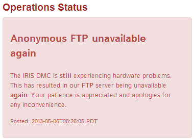
from IRIS data management center
That looks closer to where the epicenter should/might be, compared to the one listed, which still hasn't been reviewed.
It looks like parts of the IRIS website are coming back online, but I still can't get the Bud Explorer to load...
...this is probably why:
from IRIS data management center
edit on 5/6/2013 by Olivine because: (no reason given)
Going cheap, USGS have a magnitude 5.6 quake on sale for a limited time for the price of a 4.7
4.7, 2013/05/06 07:33:06, -21.115, -176.158, 16.9, FIJI REGION [usgs]
and Russians at a slightly less discount
5.0, 2013-05-06 07:33:09.0 -20.83,-176.06,33, West of Tonga Islands [ras]
others full price
LISS SNZO
5.6, 2013-05-06 07:33:04, 21.18°S, 175.89°W, 10,Tonga Islands [gfz]
5.5, 2013-05-06 07:33:06.08, 21.17S, 175.98W, 15, TONGA [emsc]
5.6, 2013-05-06, 073304, -21.50, -175.50, 33.0, TONGA ISLANDS [ldeo]
and while I'm here, this one near me yesterday, I didn't feel it though
Felt reports
strong 5
moderate 30
light 2362
weak 165
Total 2562
www.geonet.org.nz...
4.7, 2013/05/06 07:33:06, -21.115, -176.158, 16.9, FIJI REGION [usgs]
and Russians at a slightly less discount
5.0, 2013-05-06 07:33:09.0 -20.83,-176.06,33, West of Tonga Islands [ras]
others full price
LISS SNZO
5.6, 2013-05-06 07:33:04, 21.18°S, 175.89°W, 10,Tonga Islands [gfz]
5.5, 2013-05-06 07:33:06.08, 21.17S, 175.98W, 15, TONGA [emsc]
5.6, 2013-05-06, 073304, -21.50, -175.50, 33.0, TONGA ISLANDS [ldeo]
and while I'm here, this one near me yesterday, I didn't feel it though
Public ID 2013p338322
Universal Time May 6 2013 at 4:19:10
NZ Standard Time Monday, May 6 2013 at 4:19:10 pm
Latitude, Longitude -41.37, 175.11
Focal Depth 22 km
Magnitude 3.7
Location 30 km east of Wellington
Felt reports
strong 5
moderate 30
light 2362
weak 165
Total 2562
www.geonet.org.nz...
edit on 6-5-2013 by muzzy because: (no reason given)
edit on 6-5-2013 by muzzy
because: (no reason given)
reply to post by muzzy
That's just wrong...how can they be so far off from every other agency? They (USGS) need to do some serious software overhauling.
Hey Muzzy, I just finished reading this article regarding natural hazards in New Zealand. It's about a month old, but really interesting. Some excerpts:
and a bit farther down...
That's just wrong...how can they be so far off from every other agency? They (USGS) need to do some serious software overhauling.
Hey Muzzy, I just finished reading this article regarding natural hazards in New Zealand. It's about a month old, but really interesting. Some excerpts:
If you're not on a fault zone, a volcanically active zone, or a tsunami zone, you're probably in a valley that's prone to flooding or having things tumble down the hills towards you."
and a bit farther down...
Instead the probabilities behave much more like the erratic nature of the stock markets where the unexpectedly large tends to happen unexpectedly often. Which for New Zealand becomes a special concern because it only has about 150 years of good data on which to draw.
"Each time you double the period over which you are looking at geological hazards, the events become much more than twice as nasty. And so the New Zealand data does not yet provide a representative sample of the actual risks associated with its earthquakes and volcanoes.
edit on
5/6/2013 by Olivine because: clarification
reply to post by muzzy
I was going to say I will take two but then I realised it was not quite the bargain it seems. The others are Mw and Useless is mb which brings it up to just under 5.2
I only want one at that discount
I was going to say I will take two but then I realised it was not quite the bargain it seems. The others are Mw and Useless is mb which brings it up to just under 5.2
I only want one at that discount
reply to post by Olivine
thanks I'll have a read of that.
I was driving to Wellington on Friday and there was a big boulder on the road along the coast road, it had rolled off the hill, across 2 lanes and was laying to the side in the kerb against the back side of the seawall fence.
Was as big as a car wheel.
Lucky it rolled all the way across to the other side, imagine hitting that in the dark
That section of road would be a goner if we had a big quake in Wellington (7+) the whole hillside would come down, its all loose scree. I just hope I'm at home when it happens, its a 50km walk from Wellington.
reply to post by PuterMan
oh yeah
I only looked at GFZ, which was Mw.
by the time you add post and packaging its probably going to cost as much as a Mw anyway
oh yeah
I only looked at GFZ, which was Mw.
by the time you add post and packaging its probably going to cost as much as a Mw anyway
reply to post by PuterMan
That mag 2.7 near Glide, OR has been upgraded to a mag 3.3 and moved off the coast 204 km WSW of Coos Bay, OR.
Thanks for your help, that one was screwy.
That mag 2.7 near Glide, OR has been upgraded to a mag 3.3 and moved off the coast 204 km WSW of Coos Bay, OR.
Thanks for your help, that one was screwy.
reply to post by Olivine
Depth Uncertainty: 54.72 Km
On a 5km depth. A wee bit of room for error then?
You were more right than I. You said off the coast and it was My calcs could not account for the relativeness as it was all off DBO and it would have taken a huge amount of work to try and extrapolate where that was without DBO. It was not really even near but it did at least indicate that the figures were wrong.
IRIS is back up and seems to be fully operationally.
Just thought I would post a link as an example: YC.LA17.EHZ
It shows quakes still snapping at Well 3, Bayou Corne, Louisiana at a borehole depth of 284m (932 feet).
Just thought I would post a link as an example: YC.LA17.EHZ
It shows quakes still snapping at Well 3, Bayou Corne, Louisiana at a borehole depth of 284m (932 feet).
edit on 5/7/2013 by Olivine because:
correction
I live in Western Montana and I had a strange thing happen In my home yesterday. I redid my kitchen a few years ago. New floor redone from bare bones
- nice thick plywood base, and level in every area. From the week prior my floor has moved. I poured some bleach on to mop and it rolled down hill
(not really a hill but in one direction). It has never done this before. I'm on a level foundation and have lived here a long time with no problems
like this. Houses can settle but in the matter of a week move so much its noticeable? It's not tree roots as I thought of that. I didn't feel any
quakes and I imagine for movement to occur at a foundation level I would feel it. I looked it up but all I read says it would not be noticeable but is
gradual settling. Or it talks about weak foundations (mine isn't). It's probably just normal settling that happened quickly but it bothers me that
its so evident, and the change happened sometime during the course of a week. If anyone else has experienced this it would be nice for some feedback.
If it was one of these small quakes I imagine neighbors will see small changes in their homes too. Or maybe it wouldn't be as noticeable as my
example. It's just weird.
reply to post by Dianec
Could it be the ground under the house is warping due to magma or ground displacement ?
Could it be the ground under the house is warping due to magma or ground displacement ?
reply to post by Dianec
That is odd. New homes tend to settle but it generally doesn't happen in older homes unless the soil under the house is settling (too much rain or too little rain in your area?) Are your windows and/or doors opening the same as usual or are they sticking or closing on their own?
I know that I'd be concerned living in that part of the country if I thought my floor shifted. I'd probably hang a plumb bob from a nail in the wall and mark where it sits. Then I'd check often to see if the plumb bob shifts away from the mark.
Please keep us updated if you notice anything else unusual?
Hello, I dont typically post anymore, BUT there IS something going on and I would love for you technologically savy people to look further into
especially after that report from the person in Montana. And dont roll your eyes when I say Yellowstone either. LOL I've dont that a lot in my
past, rolling eyes at people shouting YELLOWSTONE. Im not a geologist, but watching geological activity is a hobby of mine and has been for over a
decade now. The Island Park Caldera is of serious concern to me now. Over the past week not only has it been rumbling, it has taken a pattern.
Quakes are getting stronger and closer to the surface. How so? A week ago they were rumbling at 54km below the surface swarms of 1.? about 20 a day.
We are now between 8 and 10km with a 2.0, 3.0, 3.6 and a 4.2 in the past day and a half not to mention the 1 and 2's inbetween. Consistantly getting
more and more shallow every day. A few of the hotsprings in the area are rumbling 0.0km.
The last time Yellowstone got mouthy and that was just a swarm not like this one.. they started pulling info. We all had a heck of a time getting anything because the typical servers were down.
As I said, Im usually the eye roller of the bunch when it comes to Yellowstone, but I REALLY think people need to pay attention to this.
Looks like USGS finally made good on their withdrawl of the old map, no longer able to pull it up.
reply to post by Dianec
Maybe your neighbors just havent noticed? Have you talked to them?
It shouldnt happen like that. Definatly unusual. My Mom's foundation settled. Im from an area that has a lot of springs, and she had a heck of a time with her foundation. If it were me, I would just keep my eyes open and see if you notice anything else both in your home and out.
Been playing around with the new USGS earthquake map format today and am liking it!!!
List, map, & options can be opened or closed for expanded map view. All options seem to update very fast & they have the satellite views back.
List, map, & options can be opened or closed for expanded map view. All options seem to update very fast & they have the satellite views back.
new topics
-
Electrical tricks for saving money
Education and Media: 1 hours ago -
VP's Secret Service agent brawls with other agents at Andrews
Mainstream News: 2 hours ago -
Sunak spinning the sickness figures
Other Current Events: 3 hours ago -
Nearly 70% Of Americans Want Talks To End War In Ukraine
Political Issues: 3 hours ago -
Late Night with the Devil - a really good unusual modern horror film.
Movies: 5 hours ago -
Cats Used as Live Bait to Train Ferocious Pitbulls in Illegal NYC Dogfighting
Social Issues and Civil Unrest: 6 hours ago -
The Good News According to Jesus - Episode 1
Religion, Faith, And Theology: 8 hours ago -
HORRIBLE !! Russian Soldier Drinking Own Urine To Survive In Battle
World War Three: 10 hours ago
top topics
-
SETI chief says US has no evidence for alien technology. 'And we never have'
Aliens and UFOs: 17 hours ago, 8 flags -
Cats Used as Live Bait to Train Ferocious Pitbulls in Illegal NYC Dogfighting
Social Issues and Civil Unrest: 6 hours ago, 8 flags -
Florida man's trip overseas ends in shock over $143,000 T-Mobile phone bill
Social Issues and Civil Unrest: 13 hours ago, 8 flags -
VP's Secret Service agent brawls with other agents at Andrews
Mainstream News: 2 hours ago, 7 flags -
Former Labour minister Frank Field dies aged 81
People: 15 hours ago, 4 flags -
Bobiverse
Fantasy & Science Fiction: 13 hours ago, 3 flags -
HORRIBLE !! Russian Soldier Drinking Own Urine To Survive In Battle
World War Three: 10 hours ago, 3 flags -
Nearly 70% Of Americans Want Talks To End War In Ukraine
Political Issues: 3 hours ago, 3 flags -
Sunak spinning the sickness figures
Other Current Events: 3 hours ago, 3 flags -
Late Night with the Devil - a really good unusual modern horror film.
Movies: 5 hours ago, 2 flags
active topics
-
HORRIBLE !! Russian Soldier Drinking Own Urine To Survive In Battle
World War Three • 29 • : doubledan717 -
-@TH3WH17ERABB17- -Q- ---TIME TO SHOW THE WORLD--- -Part- --44--
Dissecting Disinformation • 651 • : 777Vader -
VP's Secret Service agent brawls with other agents at Andrews
Mainstream News • 19 • : NoCorruptionAllowed -
VirginOfGrand says hello
Introductions • 5 • : burritocat -
The Reality of the Laser
Military Projects • 44 • : Zaphod58 -
SETI chief says US has no evidence for alien technology. 'And we never have'
Aliens and UFOs • 42 • : Boomer1947 -
NASA Researchers Discover a Parallel Universe That Runs Backwards through Time - Alongside Us
Space Exploration • 71 • : charlyv -
Sunak spinning the sickness figures
Other Current Events • 4 • : annonentity -
Cats Used as Live Bait to Train Ferocious Pitbulls in Illegal NYC Dogfighting
Social Issues and Civil Unrest • 12 • : Hakaiju -
Huge ancient city found in the Amazon.
Ancient & Lost Civilizations • 61 • : Therealbeverage